National Register of Historic Places listings in Buchanan County, Virginia
This is a list of the National Register of Historic Places listings in Buchanan County, Virginia.
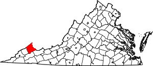
Location of Buchanan County in Virginia
This is intended to be a detailed table of the property on the National Register of Historic Places in Buchanan County, Virginia, United States. The locations of National Register properties and districts for which the latitude and longitude coordinates are included below, may be seen in a Google map.[1]
There is 1 property listed on the National Register in the county. Another property was once listed but has been removed.
- This National Park Service list is complete through NPS recent listings posted June 19, 2020.[2]
Current listings
| [3] | Name on the Register[4] | Image | Date listed[5] | Location | City or town | Description |
|---|---|---|---|---|---|---|
| 1 | Buchanan County Courthouse | 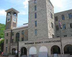 Buchanan County Courthouse |
September 16, 1982 (#82004545) |
Walnut and Main Sts. 37°16′40″N 82°05′57″W |
Grundy |
Former listing
| [3] | Name on the Register | Image | Date listed | Date removed | Location | City or town | Summary |
|---|---|---|---|---|---|---|---|
| 1 | Whitewood High School | 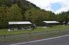 Whitewood High School |
September 12, 2008 (#08000893) | October 11, 2016 | 17424 Dismal River Rd. 37°14′33″N 81°52′18″W |
Whitewood | Demolished in June 2010 |
See also
| Wikimedia Commons has media related to National Register of Historic Places in Buchanan County, Virginia. |
References
- The latitude and longitude information provided in this table was derived originally from the National Register Information System, which has been found to be fairly accurate for about 99% of listings. Some locations in this table may have been corrected to current GPS standards.
- "National Register of Historic Places: Weekly List Actions". National Park Service, United States Department of the Interior. Retrieved on June 19, 2020.
- Numbers represent an ordering by significant words. Various colorings, defined here, differentiate National Historic Landmarks and historic districts from other NRHP buildings, structures, sites or objects.
- "National Register Information System". National Register of Historic Places. National Park Service. April 24, 2008.
- The eight-digit number below each date is the number assigned to each location in the National Register Information System database, which can be viewed by clicking the number.

Municipalities and communities of Buchanan County, Virginia, United States | ||
|---|---|---|
| Town | Map of Virginia highlighting Buchanan County | |
| CDP | ||
| Unincorporated communities |
| |
| Footnotes | ‡This populated place also has portions in an adjacent county or counties | |
This article is issued from Wikipedia. The text is licensed under Creative Commons - Attribution - Sharealike. Additional terms may apply for the media files.