National Register of Historic Places listings in Roanoke County, Virginia
This is a list of the National Register of Historic Places listings in Roanoke County, Virginia.

Location of Roanoke County in Virginia
This is intended to be a complete list of the properties and districts on the National Register of Historic Places in Roanoke County, Virginia, United States. The locations of National Register properties and districts for which the latitude and longitude coordinates are included below, may be seen in an online map.[1]
There are 10 properties and districts listed on the National Register in the county.
- This National Park Service list is complete through NPS recent listings posted June 19, 2020.[2]
Current listings
| [3] | Name on the Register[4] | Image | Date listed[5] | Location | City or town | Description |
|---|---|---|---|---|---|---|
| 1 | Anderson-Doosing Farm | 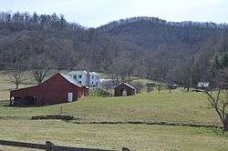 Anderson-Doosing Farm |
August 27, 2009 (#09000666) |
7474 Blacksburg Rd. 37°19′49″N 80°11′42″W |
Catawba | |
| 2 | Black Horse Tavern-Bellvue Hotel and Office | 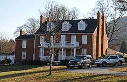 Black Horse Tavern-Bellvue Hotel and Office |
January 24, 2002 (#01001521) |
7223-7229 Old Mountain Rd. 37°20′47″N 79°54′53″W |
Hollins | |
| 3 | William Byrd High School Historic District | 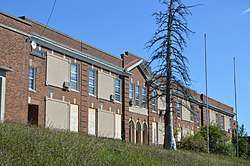 William Byrd High School Historic District |
June 12, 2017 (#100001082) |
100 and 156 Highland Rd. 37°16′56″N 79°54′02″W |
Vinton | |
| 4 | Roland E. Cook Elementary School | 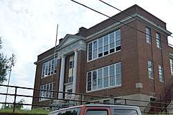 Roland E. Cook Elementary School |
May 12, 2016 (#16000262) |
412 S. Poplar St. 37°16′37″N 79°53′44″W |
Vinton | |
| 5 | Harshbarger House | 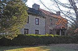 Harshbarger House |
October 15, 1992 (#92001390) |
316 John Richardson Rd. 37°19′19″N 79°56′15″W |
Hollins | |
| 6 | Hollins College Quadrangle | 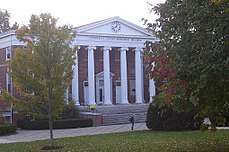 Hollins College Quadrangle |
November 5, 1974 (#74002145) |
Hollins University campus 37°21′17″N 79°56′31″W |
Hollins | |
| 7 | Johnsville Meetinghouse | 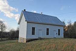 Johnsville Meetinghouse |
October 30, 1998 (#98001308) |
8860 Johnsville Church Rd. 37°18′56″N 80°14′48″W |
Catawba | |
| 8 | Old Tombstone | 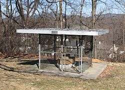 Old Tombstone |
March 25, 1980 (#80004222) |
Plantation Rd. 37°20′25″N 79°56′31″W |
Hollins | |
| 9 | Pleasant Grove |  Pleasant Grove |
May 22, 2003 (#03000449) |
4377 W. Main St. 37°16′13″N 80°08′31″W |
Salem | |
| 10 | Starkey School | 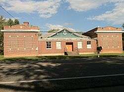 Starkey School |
January 24, 2002 (#01001513) |
6426 Merriman Rd., SW. 37°12′08″N 79°59′57″W |
Starkey |
See also
| Wikimedia Commons has media related to National Register of Historic Places in Roanoke County, Virginia. |
References
- The latitude and longitude information provided in this table was derived originally from the National Register Information System, which has been found to be fairly accurate for about 99% of listings. Some locations in this table may have been corrected to current GPS standards.
- "National Register of Historic Places: Weekly List Actions". National Park Service, United States Department of the Interior. Retrieved on June 19, 2020.
- Numbers represent an ordering by significant words. Various colorings, defined here, differentiate National Historic Landmarks and historic districts from other NRHP buildings, structures, sites or objects.
- "National Register Information System". National Register of Historic Places. National Park Service. April 24, 2008.
- The eight-digit number below each date is the number assigned to each location in the National Register Information System database, which can be viewed by clicking the number.

Municipalities and communities of Roanoke County, Virginia, United States | ||
|---|---|---|
| Town | Map of Virginia highlighting Roanoke County | |
| CDPs | ||
| Unincorporated communities | ||
| Footnotes | ‡This populated place also has portions in an adjacent county or counties | |
This article is issued from Wikipedia. The text is licensed under Creative Commons - Attribution - Sharealike. Additional terms may apply for the media files.