National Register of Historic Places listings in Washington County, Virginia
This is a list of the National Register of Historic Places listings in Washington County, Virginia.
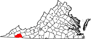
Location of Washington County in Virginia
This is intended to be a complete list of the properties and districts on the National Register of Historic Places in Washington County, Virginia, United States. The locations of National Register properties and districts for which the latitude and longitude coordinates are included below, may be seen in an online map.[1]
There are 16 properties and districts listed on the National Register in the county.
- This National Park Service list is complete through NPS recent listings posted June 26, 2020.[2]
Current listings
| [3] | Name on the Register[4] | Image | Date listed[5] | Location | City or town | Description |
|---|---|---|---|---|---|---|
| 1 | Abingdon Bank | 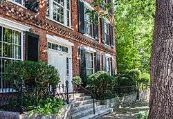 Abingdon Bank |
November 12, 1969 (#69000285) |
225 E. Main St. 36°42′46″N 81°58′10″W |
Abingdon | |
| 2 | Abingdon Historic District | 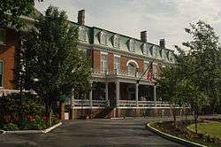 Abingdon Historic District |
February 26, 1970 (#70000831) |
Both sides of Main St. between Cummings and Deadmore Sts.; also roughly bounded by Russell Rd. and Jackson St., Whites Mill Rd., E. Main, E. Park, and W. Main Sts., and Academy Dr. 36°42′42″N 81°58′18″W |
Abingdon | Second set of boundaries represents a boundary increase of September 17, 1986 |
| 3 | Baker-St. John House | 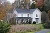 Baker-St. John House |
February 22, 2011 (#11000033) |
18254 Providence Rd. 36°41′08″N 82°02′28″W |
Abingdon | |
| 4 | Brook Hall |  Brook Hall |
June 5, 1997 (#97000490) |
13160 Byars Ln. 36°45′47″N 81°48′10″W |
Glade Spring | |
| 5 | Crabtree-Blackwell Farm |  Crabtree-Blackwell Farm |
April 1, 1975 (#75002041) |
1 mile south of Blackwell on Moore Creek Rd. 36°49′04″N 81°51′12″W |
Blackwell | |
| 6 | Edmondson Hall | 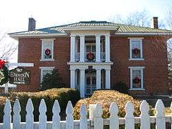 Edmondson Hall |
June 11, 1998 (#98000697) |
Lindell Rd., 0.25 miles north of the junction of State Route 80 and the Hillman Highway 36°45′45″N 81°51′52″W |
Meadowview | |
| 7 | Emory and Henry College |  Emory and Henry College |
January 30, 1989 (#85003695) |
Oxford Ave. 36°46′21″N 81°49′55″W |
Emory | |
| 8 | Glade Spring Commercial Historic District | 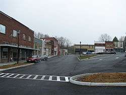 Glade Spring Commercial Historic District |
May 28, 2013 (#13000345) |
Portions of Town Square St., Grace St., E. Glade St., and Hemlock St. 36°47′26″N 81°46′16″W |
Glade Spring | Twenty-two contributing buildings and one contributing structure.[6] |
| 9 | The Grove | 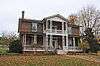 The Grove |
May 16, 2002 (#02000525) |
14071 U.S. Routes 11/19 36°38′27″N 82°06′34″W |
Bristol | |
| 10 | Mont Calm | 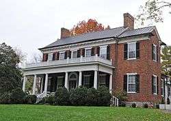 Mont Calm |
July 18, 1974 (#74002148) |
West of State Route 75 36°42′27″N 81°58′24″W |
Abingdon | |
| 11 | Moonlite Theatre | 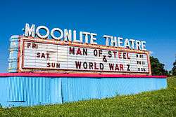 Moonlite Theatre |
August 8, 2007 (#07000802) |
17555 U.S. Routes 11/19 36°40′35″N 82°02′55″W |
Abingdon | Drive-in theater built in 1949. |
| 12 | Dr. William H. Pitts House | 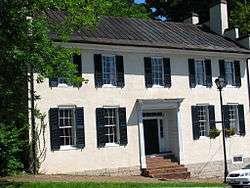 Dr. William H. Pitts House |
April 1, 2002 (#02000322) |
247 E. Main St. 36°42′47″N 81°58′07″W |
Abingdon | |
| 13 | Retirement and the Muster Grounds |  Retirement and the Muster Grounds |
May 11, 2018 (#100002441) |
702 Colonial Rd. SW 36°42′14″N 81°59′39″W |
Abingdon | |
| 14 | Saltville Battlefields Historic District |  Saltville Battlefields Historic District |
March 25, 2010 (#10000096) |
State Routes 91 and 107, and Cedar Branch Rd. 36°52′00″N 81°46′48″W |
Saltville | Extends into Smyth County |
| 15 | Walnut Grove | 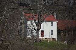 Walnut Grove |
August 11, 2004 (#04000840) |
14081 U.S. Routes 11/19 36°38′16″N 82°07′06″W |
Bristol | |
| 16 | White's Mill | 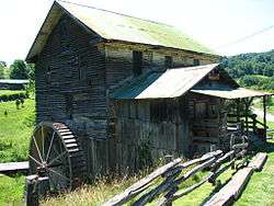 White's Mill |
September 10, 1974 (#74002149) |
Northwest of Abingdon on White Mill Rd. 36°46′05″N 81°59′17″W |
Abingdon |
See also
| Wikimedia Commons has media related to National Register of Historic Places in Washington County, Virginia. |
References
- The latitude and longitude information provided in this table was derived originally from the National Register Information System, which has been found to be fairly accurate for about 99% of listings. Some locations in this table may have been corrected to current GPS standards.
- "National Register of Historic Places: Weekly List Actions". National Park Service, United States Department of the Interior. Retrieved on June 26, 2020.
- Numbers represent an ordering by significant words. Various colorings, defined here, differentiate National Historic Landmarks and historic districts from other NRHP buildings, structures, sites or objects.
- "National Register Information System". National Register of Historic Places. National Park Service. April 24, 2008.
- The eight-digit number below each date is the number assigned to each location in the National Register Information System database, which can be viewed by clicking the number.
- NPS

Municipalities and communities of Washington County, Virginia, United States | ||
|---|---|---|
| Towns | Map of Virginia highlighting Washington County | |
| CDPs | ||
| Unincorporated communities |
| |
| Footnotes | ‡This populated place also has portions in an adjacent county or counties | |
This article is issued from Wikipedia. The text is licensed under Creative Commons - Attribution - Sharealike. Additional terms may apply for the media files.