National Register of Historic Places listings in Richmond County, Virginia
This is a list of the National Register of Historic Places listings in Richmond County, Virginia.
Location of Richmond County in Virginia
This is intended to be a complete list of the properties and districts on the National Register of Historic Places in Richmond County, Virginia, United States. The locations of National Register properties and districts for which the latitude and longitude coordinates are included below, may be seen in a Google map.[1]
There are 9 properties and districts listed on the National Register in the county, including 3 National Historic Landmarks. Another property was once listed but has been removed.
- This National Park Service list is complete through NPS recent listings posted June 19, 2020.[2]
Current listings
| [3] | Name on the Register[4] | Image | Date listed[5] | Location | City or town | Description |
|---|---|---|---|---|---|---|
| 1 | Farnham Church | %2C_State_Routes_602_%26_607%2C_Farnham_(Richmond_County%2C_Virginia).jpg) Farnham Church |
August 14, 1973 (#73002053) |
State Route 3 37°53′09″N 76°37′31″W |
Farnham | |
| 2 | Grove Mount | 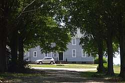 Grove Mount |
January 3, 1991 (#90001995) |
Junction of Newland and Grove Mount Rds. 38°00′42″N 76°49′58″W |
Warsaw | |
| 3 | Indian Banks | .jpg) Indian Banks |
March 20, 1980 (#80004218) |
Simonson Rd.[6] 37°48′35″N 76°37′55″W |
Simonson | |
| 4 | Linden Farm | .jpg) Linden Farm |
April 13, 1977 (#77001492) |
North of Farnham on State Route 3 37°53′25″N 76°37′59″W |
Farnham | |
| 5 | Menokin | 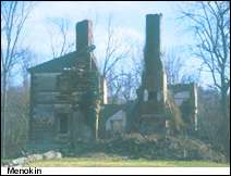 Menokin |
October 1, 1969 (#69000276) |
Northwest of the junction of Menokin and Chestnut Hill Rds. 38°00′30″N 76°48′13″W |
Warsaw | |
| 6 | Mount Airy | 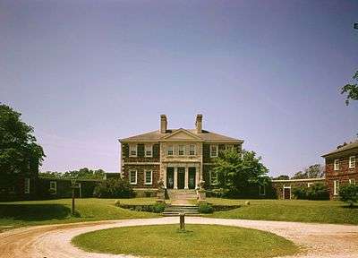 Mount Airy |
October 15, 1966 (#66000845) |
West of Warsaw on U.S. Route 360 37°58′15″N 76°47′28″W |
Warsaw | |
| 7 | Richmond County Courthouse | 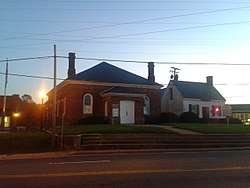 Richmond County Courthouse |
December 5, 1972 (#72001413) |
Junction of U.S. Route 360 and State Route 3 37°57′29″N 76°45′27″W |
Warsaw | |
| 8 | Sabine Hall | .jpg) Sabine Hall |
November 12, 1969 (#69000277) |
South of the junction of U.S. Route 360 and Sabine Hall Rd. 37°56′24″N 76°47′05″W |
Tappahannock | |
| 9 | Woodford | 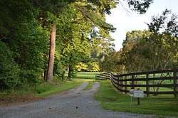 Woodford |
February 24, 1983 (#83003311) |
Ivondale Rd. 37°49′59″N 76°40′15″W |
Simons Corner |
Former listing
| [3] | Name on the Register | Image | Date listed | Date removed | Location | City or town | Summary |
|---|---|---|---|---|---|---|---|
| 1 | Bladensfield | October 31, 1980 (#80004219) | March 19, 2001 | NE of Warsaw off VA 203 |
Warsaw | Destroyed by fire November 1996 |
See also
| Wikimedia Commons has media related to National Register of Historic Places in Richmond County, Virginia. |
References
- The latitude and longitude information provided in this table was derived originally from the National Register Information System, which has been found to be fairly accurate for about 99% of listings. Some locations in this table may have been corrected to current GPS standards.
- "National Register of Historic Places: Weekly List Actions". National Park Service, United States Department of the Interior. Retrieved on June 19, 2020.
- Numbers represent an ordering by significant words. Various colorings, defined here, differentiate National Historic Landmarks and historic districts from other NRHP buildings, structures, sites or objects.
- "National Register Information System". National Register of Historic Places. National Park Service. April 24, 2008.
- The eight-digit number below each date is the number assigned to each location in the National Register Information System database, which can be viewed by clicking the number.
- Photographs: Written Historical and Descriptive Data: Indian Banks, Historic American Buildings Survey, n.d., 2. Accessed 2017-04-04.

This article is issued from Wikipedia. The text is licensed under Creative Commons - Attribution - Sharealike. Additional terms may apply for the media files.