National Register of Historic Places listings in Tazewell County, Virginia
This is a list of the National Register of Historic Places listings in Tazewell County, Virginia.
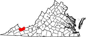
Location of Tazewell County in Virginia
This is intended to be a complete list of the properties and districts on the National Register of Historic Places in Tazewell County, Virginia, United States. The locations of National Register properties and districts for which the latitude and longitude coordinates are included below, may be seen in a Google map.[1]
There are 22 properties and districts listed on the National Register in the county, including 1 National Historic Landmark.
- This National Park Service list is complete through NPS recent listings posted June 19, 2020.[2]
Current listings
| [3] | Name on the Register[4] | Image | Date listed[5] | Location | City or town | Description |
|---|---|---|---|---|---|---|
| 1 | Big Crab Orchard Site | 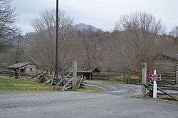 Big Crab Orchard Site |
August 11, 1980 (#80004230) |
Grounds of Historic Crab Orchard Museum, 3663 Crab Orchard Rd.[6] 37°07′10″N 81°34′28″W |
Tazewell | |
| 2 | Bull Thistle Cave Archeological Site (44TZ92) | September 10, 1987 (#87001531) |
Address Restricted |
Tazewell | ||
| 3 | Burke's Garden Central Church And Cemetery |  Burke's Garden Central Church And Cemetery |
May 7, 1979 (#79003092) |
Southeast of Burke's Garden on Burkes Garden Rd. 37°05′33″N 81°20′10″W |
Burke's Garden | |
| 4 | Burke's Garden Rural Historic District | 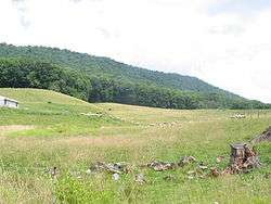 Burke's Garden Rural Historic District |
February 25, 1986 (#86000306) |
Valley encircled by Garden Mountain 37°05′51″N 81°20′23″W |
Tazewell | |
| 5 | Chimney Rock Farm | 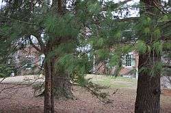 Chimney Rock Farm |
July 8, 1982 (#82004607) |
State Route 91 37°04′40″N 81°36′31″W |
Tazewell | |
| 6 | Clinch Valley Roller Mills | 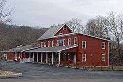 Clinch Valley Roller Mills |
October 4, 1984 (#84000056) |
River Street Dr. 37°05′18″N 81°45′57″W |
Cedar Bluff | |
| 7 | Clynchdale |  Clynchdale |
August 15, 2016 (#16000540) |
146 Beartown Rd. 37°04′51″N 81°28′31″W |
Tazewell | |
| 8 | Indian Paintings | December 3, 1969 (#69000284) |
Address Restricted |
Maiden Spring | ||
| 9 | Maiden Spring | 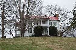 Maiden Spring |
August 16, 1994 (#94000987) |
Junction of State Route 91 and Wardell Rd. 37°01′48″N 81°41′01″W |
Pounding Mill | |
| 10 | Capt. James Moore Homestead | 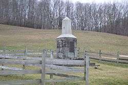 Capt. James Moore Homestead |
November 24, 2002 (#02001363) |
Abbs Valley Rd. 37°16′07″N 81°23′38″W |
Boissevain | |
| 11 | Old Kentucky Turnpike Historic District | 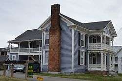 Old Kentucky Turnpike Historic District |
July 7, 1995 (#95000829) |
Along Indian Creek Rd., Old Kentucky Turnpike, College Hill Rd., and Cedar Valley Dr. 37°05′21″N 81°45′42″W |
Cedar Bluff | |
| 12 | Pocahontas Historic District |  Pocahontas Historic District |
November 3, 1972 (#72001418) |
Corporate boundaries of Pocahontas including cemetery 37°18′20″N 81°20′20″W |
Pocahontas | |
| 13 | Pocahontas Mine No. 1 |  Pocahontas Mine No. 1 |
October 12, 1994 (#94001651) |
Shop Hollow Rd. 37°18′27″N 81°20′46″W |
Pocahontas | |
| 14 | Richlands Historic District |  Richlands Historic District |
May 2, 2007 (#07000394) |
Includes portions of Front, 2nd, 3rd, and 4th Sts., and Grayson Ave., Lee St., Washington Sq., and Suffolk Ave. 37°05′40″N 81°47′45″W |
Richlands | |
| 15 | Alexander St. Clair House |  Alexander St. Clair House |
June 28, 1982 (#82004606) |
West of Bluefield on Hockman Pike 37°13′58″N 81°18′53″W |
Bluefield | |
| 16 | Walter McDonald Sanders House |  Walter McDonald Sanders House |
November 21, 2002 (#02001370) |
College Ave. 37°14′20″N 81°15′34″W |
Bluefield | |
| 17 | Tazewell Avenue Historic District | 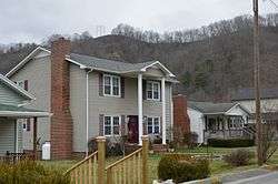 Tazewell Avenue Historic District |
March 31, 2010 (#10000147) |
Tazewell Ave., Fairfax Ave., Front St., 2nd St., 3rd St., and 4th St. 37°05′49″N 81°48′24″W |
Richlands | |
| 18 | Tazewell Depot |  Tazewell Depot |
February 17, 2015 (#15000020) |
135 Railroad Ave. 37°07′58″N 81°31′35″W |
Tazewell | |
| 19 | Tazewell Historic District | 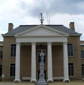 Tazewell Historic District |
May 16, 2002 (#02000519) |
Main, Church, Tower, and Pine Sts., Central Ave., and Fincastle Turnpike; also the 100 block of W. Fincastle Turnpike, the 200 and 300 blocks of W. Main St., and the 300 block of W. Pine St. 37°06′58″N 81°31′12″W |
Tazewell | Second set of addresses represents a boundary increase 2016-08-15 |
| 20 | George Oscar Thompson House |  George Oscar Thompson House |
June 28, 1982 (#82004608) |
Thompson Valley Rd. 37°04′20″N 81°33′18″W |
Tazewell | |
| 21 | Williams House | 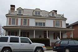 Williams House |
July 7, 1983 (#83003319) |
102 Suffolk Ave. 37°05′37″N 81°47′54″W |
Richlands | |
| 22 | James Wynn House | 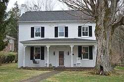 James Wynn House |
October 28, 1992 (#92001368) |
408 S. Elk St. 37°06′52″N 81°31′08″W |
Tazewell |
See also
| Wikimedia Commons has media related to National Register of Historic Places in Tazewell County, Virginia. |
References
- The latitude and longitude information provided in this table was derived originally from the National Register Information System, which has been found to be fairly accurate for about 99% of listings. Some locations in this table may have been corrected to current GPS standards.
- "National Register of Historic Places: Weekly List Actions". National Park Service, United States Department of the Interior. Retrieved on June 19, 2020.
- Numbers represent an ordering by significant words. Various colorings, defined here, differentiate National Historic Landmarks and historic districts from other NRHP buildings, structures, sites or objects.
- "National Register Information System". National Register of Historic Places. National Park Service. April 24, 2008.
- The eight-digit number below each date is the number assigned to each location in the National Register Information System database, which can be viewed by clicking the number.
- Mission and History, Historic Crab Orchard Museum, 2014. Accessed 2017-01-14.

Municipalities and communities of Tazewell County, Virginia, United States | ||
|---|---|---|
| Towns | Map of Virginia highlighting Tazewell County | |
| CDPs | ||
| Unincorporated communities | ||
| Footnotes | ‡This populated place also has portions in an adjacent county or counties | |
This article is issued from Wikipedia. The text is licensed under Creative Commons - Attribution - Sharealike. Additional terms may apply for the media files.