National Register of Historic Places listings in Wise County, Virginia
This is a list of the National Register of Historic Places listings in Wise County, Virginia.
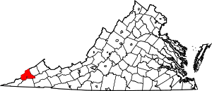
Location of Wise County in Virginia
This is intended to be a complete list of the properties and districts on the National Register of Historic Places in Wise County, Virginia, United States. The locations of National Register properties and districts for which the latitude and longitude coordinates are included below, may be seen in an online map.[1]
There are 20 properties and districts listed on the National Register in the county.
- This National Park Service list is complete through NPS recent listings posted June 19, 2020.[2]
Current listings
| [3] | Name on the Register | Image | Date listed[4] | Location | City or town | Description |
|---|---|---|---|---|---|---|
| 1 | Appalachia Commercial Historic District | 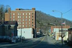 Appalachia Commercial Historic District |
August 6, 2019 (#100004258) |
Along W. Main St., Kentucky Ave., and Powell St. 36°54′16″N 82°47′02″W |
Appalachia | |
| 2 | Big Stone Gap Downtown Historic District | 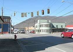 Big Stone Gap Downtown Historic District |
March 13, 2019 (#100003482) |
200-500 Wood Ave., E. Shawnee Ave., E. 3rd St., E. 4th St., and E. 5th St. 36°52′00″N 82°46′32″W |
Big Stone Gap | |
| 3 | Christ Episcopal Church |  Christ Episcopal Church |
December 19, 1990 (#89001905) |
100 Clinton Ave. 36°51′51″N 82°46′36″W |
Big Stone Gap | |
| 4 | Colonial Hotel | 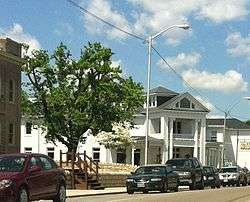 Colonial Hotel |
February 5, 1991 (#91000019) |
Junction of Main and Spring Sts. 36°58′39″N 82°34′49″W |
Wise | |
| 5 | Country Cabin | 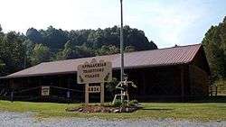 Country Cabin |
October 27, 1992 (#92001395) |
Junction of Old U.S. Route 23 and Norton Rd. 36°55′35″N 82°40′24″W |
Norton | |
| 6 | Derby Historic District |  Derby Historic District |
January 16, 2004 (#03001436) |
Derby Rd. from a point beginning 1 mile (1.6 km) above the junction with State Route 78 and extending for 1.2 miles (1.9 km) to the northwest 36°56′05″N 82°49′21″W |
Appalachia | |
| 7 | Flat Gap High School | 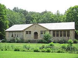 Flat Gap High School |
March 6, 2009 (#09000123) |
North Fork Rd. 37°05′00″N 82°41′36″W |
Pound | |
| 8 | John Fox, Jr. House | 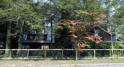 John Fox, Jr. House |
June 7, 1974 (#74002151) |
117 Shawnee Ave. 36°51′58″N 82°46′42″W |
Big Stone Gap | |
| 9 | E. M. Fulton House | 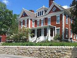 E. M. Fulton House |
February 1, 2006 (#05001581) |
103 W. Main St. 36°58′41″N 82°34′50″W |
Wise | |
| 10 | Kelly View School | 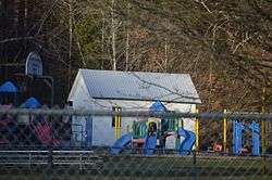 Kelly View School |
August 30, 2006 (#06000752) |
Appalachia Elementary School, Old U.S. Route 23 36°55′33″N 82°44′38″W |
Appalachia | |
| 11 | St. Paul Historic District | 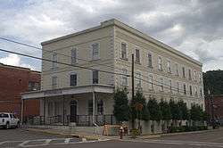 St. Paul Historic District |
June 8, 2011 (#11000351) |
Portions of 4th and 5th Aves. and Russell and Broad Sts. 36°54′19″N 82°18′38″W |
St. Paul | |
| 12 | Southwest Virginia Museum Historical State Park |  Southwest Virginia Museum Historical State Park |
November 22, 2002 (#02001362) |
10 W. 1st St., N. 36°51′49″N 82°46′48″W |
Big Stone Gap | |
| 13 | Stonega Historic District | 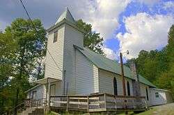 Stonega Historic District |
January 16, 2004 (#03001435) |
Stonega Rd. from 0.1 mi. north of the junction with Roda Rd. to a point approximately 3 mi. to the northeast 36°57′12″N 82°47′22″W |
Appalachia | |
| 14 | Sunnydale Farm | 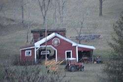 Sunnydale Farm |
June 8, 2011 (#11000352) |
12439 Sunnydale Farm Rd. 37°09′20″N 82°33′33″W |
Pound | |
| 15 | Tacoma School | 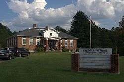 Tacoma School |
September 12, 1997 (#97001072) |
4408 Stone Mountain Rd. 36°56′06″N 82°31′55″W |
Coeburn | |
| 16 | Terrace Park Girl Scout Cabin |  Terrace Park Girl Scout Cabin |
November 1, 2007 (#07001146) |
211 Proctor St., N. 36°51′56″N 82°46′52″W |
Big Stone Gap | |
| 17 | "June Tolliver" House |  "June Tolliver" House |
August 28, 1973 (#73002067) |
522 Clinton Ave., E. 36°52′02″N 82°46′22″W |
Big Stone Gap | |
| 18 | U.S. Post Office and Courthouse |  U.S. Post Office and Courthouse |
December 23, 1975 (#75002043) |
322 Wood Ave., E.[5] 36°52′01″N 82°46′30″W |
Big Stone Gap | |
| 19 | Virginia City Church | 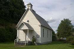 Virginia City Church |
November 16, 2005 (#05001263) |
Bull Run Rd. 36°55′06″N 82°20′49″W |
St. Paul | |
| 20 | Wise County Courthouse |  Wise County Courthouse |
March 2, 1981 (#81000649) |
206 E. Main St. 36°58′37″N 82°34′46″W |
Wise |
See also
| Wikimedia Commons has media related to National Register of Historic Places in Wise County, Virginia. |
References
- The latitude and longitude information provided in this table was derived originally from the National Register Information System, which has been found to be fairly accurate for about 99% of listings. Some locations in this table may have been corrected to current GPS standards.
- "National Register of Historic Places: Weekly List Actions". National Park Service, United States Department of the Interior. Retrieved on June 19, 2020.
- Numbers represent an ordering by significant words. Various colorings, defined here, differentiate National Historic Landmarks and historic districts from other NRHP buildings, structures, sites or objects.
- The eight-digit number below each date is the number assigned to each location in the National Register Information System database, which can be viewed by clicking the number.
- Address based on USPS website. Accessed April 12, 2016.

Municipalities and communities of Wise County, Virginia, United States | ||
|---|---|---|
| Towns | Map of Virginia highlighting Wise County | |
| CDP | ||
| Unincorporated communities | ||
| Footnotes | ‡This populated place also has portions in an adjacent county or counties | |
This article is issued from Wikipedia. The text is licensed under Creative Commons - Attribution - Sharealike. Additional terms may apply for the media files.