National Register of Historic Places listings in Lunenburg County, Virginia
This is a list of the National Register of Historic Places listings in Lunenburg County, Virginia.
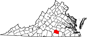
Location of Lunenburg County in Virginia
This is intended to be a complete list of the properties and districts on the National Register of Historic Places in Lunenburg County, Virginia, United States. The locations of National Register properties and districts for which the latitude and longitude coordinates are included below, may be seen in a Google map.[1]
There are 10 properties and districts listed on the National Register in the county.
- This National Park Service list is complete through NPS recent listings posted June 19, 2020.[2]
Current listings
| [3] | Name on the Register[4] | Image | Date listed[5] | Location | City or town | Description |
|---|---|---|---|---|---|---|
| 1 | Bechelbronn | 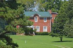 Bechelbronn |
May 8, 2008 (#08000389) |
1223 Rubermont Rd. 37°04′03″N 78°10′45″W |
Victoria | |
| 2 | Brickland | 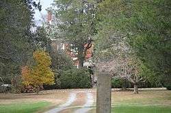 Brickland |
June 1, 2005 (#05000524) |
6877 Brickland Rd. 36°52′53″N 78°05′15″W |
Kenbridge | |
| 3 | Eubank Hall | 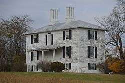 Eubank Hall |
March 29, 2007 (#07000233) |
319 Eubanks Rd. 36°57′12″N 78°28′26″W |
Fort Mitchell | |
| 4 | Fifth Avenue Historic District | 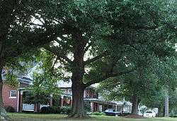 Fifth Avenue Historic District |
February 22, 2006 (#06000066) |
100-500 blocks of E. 5th Ave. 36°57′38″N 78°07′11″W |
Kenbridge | |
| 5 | Flat Rock | 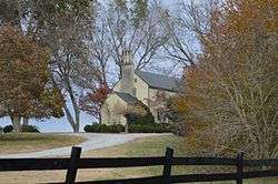 Flat Rock |
May 21, 1979 (#79003051) |
Southwest of Kenbridge on Plank Rd. 36°56′16″N 78°08′57″W |
Kenbridge | |
| 6 | Fort Mitchell Depot |  Fort Mitchell Depot |
August 20, 2009 (#09000640) |
5570-5605 Fort Mitchell Dr. 36°55′04″N 78°29′05″W |
Fort Mitchell | |
| 7 | Jones Farm | 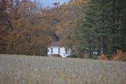 Jones Farm |
September 27, 1996 (#96001052) |
Afton Grove Rd., approximately 0.75 miles north of its junction with Brickland Rd. 36°54′02″N 78°06′44″W |
Kenbridge | |
| 8 | Lunenburg Courthouse Historic District |  Lunenburg Courthouse Historic District |
February 23, 1972 (#72001509) |
Junction of State Routes 40 and 49 with Hardy Rd. 36°57′42″N 78°15′58″W |
Lunenburg | |
| 9 | Spring Bank | 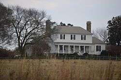 Spring Bank |
August 16, 2007 (#07000825) |
1070 Courthouse Rd. 36°52′12″N 78°24′38″W |
Lunenburg Courthouse | |
| 10 | Victoria High School | 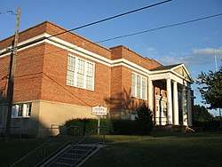 Victoria High School |
January 22, 1996 (#95001561) |
Junction of 8th St. and Lee Ave. 36°59′46″N 78°13′28″W |
Victoria |
See also
| Wikimedia Commons has media related to National Register of Historic Places in Lunenburg County, Virginia. |
References
- The latitude and longitude information provided in this table was derived originally from the National Register Information System, which has been found to be fairly accurate for about 99% of listings. Some locations in this table may have been corrected to current GPS standards.
- "National Register of Historic Places: Weekly List Actions". National Park Service, United States Department of the Interior. Retrieved on June 19, 2020.
- Numbers represent an ordering by significant words. Various colorings, defined here, differentiate National Historic Landmarks and historic districts from other NRHP buildings, structures, sites or objects.
- "National Register Information System". National Register of Historic Places. National Park Service. April 24, 2008.
- The eight-digit number below each date is the number assigned to each location in the National Register Information System database, which can be viewed by clicking the number.

Municipalities and communities of Lunenburg County, Virginia, United States | ||
|---|---|---|
| Towns | Map of Virginia highlighting Lunenburg County | |
| CDP | ||
| Unincorporated communities | ||
This article is issued from Wikipedia. The text is licensed under Creative Commons - Attribution - Sharealike. Additional terms may apply for the media files.