National Register of Historic Places listings in Bath County, Virginia
This is a list of the National Register of Historic Places listings in Bath County, Virginia.
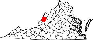
Location of Bath County in Virginia
This is intended to be a complete list of the properties and districts on the National Register of Historic Places in Bath County, Virginia, United States. The locations of National Register properties and districts for which the latitude and longitude coordinates are included below, may be seen in an online map.[1]
There are 23 properties and districts listed on the National Register in the county, including 1 National Historic Landmark.
- This National Park Service list is complete through NPS recent listings posted June 26, 2020.[2]
Current listings
| [3] | Name on the Register[4] | Image | Date listed[5] | Location | City or town | Description |
|---|---|---|---|---|---|---|
| 1 | Ashwood School |  Ashwood School |
July 28, 2016 (#16000484) |
5604 U.S. Route 220 37°58′22″N 79°50′57″W |
Hot Springs | |
| 2 | Barton Lodge | 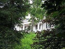 Barton Lodge |
December 24, 2013 (#13000984) |
373 French's Hill Dr. 37°59′47″N 79°50′04″W |
Hot Springs | |
| 3 | Camp Alkulana Historic District | 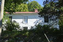 Camp Alkulana Historic District |
April 6, 2015 (#15000135) |
111 Alkulana Camp Rd. 37°59′31″N 79°37′13″W |
Millboro Springs | |
| 4 | Camp Mont Shenandoah Historic District | 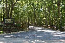 Camp Mont Shenandoah Historic District |
April 6, 2015 (#15000136) |
218 Mont Shenandoah Ln. 37°59′15″N 79°38′42″W |
Millboro Springs | |
| 5 | Douthat State Park Historic District |  Douthat State Park Historic District |
September 20, 1986 (#86002183) |
Douthat State Park Rd. 37°54′10″N 79°48′09″W |
Millboro | |
| 6 | Fort Lewis | 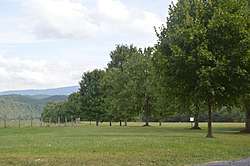 Fort Lewis |
April 4, 2019 (#100003602) |
603 Old Plantation Way 38°06′58″N 79°36′44″W |
Millboro | |
| 7 | Garth Newel | 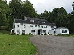 Garth Newel |
June 19, 2013 (#13000402) |
447 Garth Newel Ln. 38°01′27″N 79°47′53″W |
Hot Springs | |
| 8 | Hidden Valley | 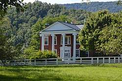 Hidden Valley |
February 26, 1970 (#70000784) |
North of Bacova near the junction of State Route 39 and McGuffin Rd. in the George Washington National Forest 38°06′22″N 79°48′52″W |
Bacova | |
| 9 | Hidden Valley Rock Shelter (44BA31) | 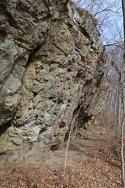 Hidden Valley Rock Shelter (44BA31) |
July 22, 1986 (#86001945) |
Northern side of the Jackson River, east of its confluence with Hidden Run[6] 38°06′20″N 79°48′32″W |
Warm Springs | |
| 10 | Homestead Dairy Barns | 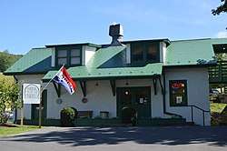 Homestead Dairy Barns |
February 13, 2007 (#07000051) |
U.S. Route 220 38°03′02″N 79°46′59″W |
Warm Springs | |
| 11 | The Homestead | 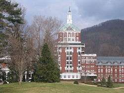 The Homestead |
May 3, 1984 (#84003494) |
U.S. Route 220 37°59′49″N 79°49′50″W |
Hot Springs | |
| 12 | Millboro School |  Millboro School |
January 16, 2004 (#03001439) |
Junction of High and Main Sts. 37°58′43″N 79°36′12″W |
Millboro | |
| 13 | Mustoe House | 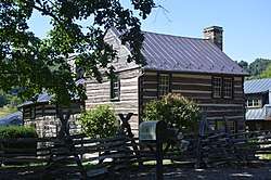 Mustoe House |
April 12, 2002 (#02000363) |
U.S. Route 220 37°55′17″N 79°53′26″W |
Hot Springs | |
| 14 | Oakley Farm | 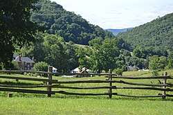 Oakley Farm |
August 8, 2007 (#07000803) |
11865 U.S. Route 220 38°02′36″N 79°47′23″W |
Warm Springs | |
| 15 | Old Stone House | 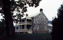 Old Stone House |
February 10, 1983 (#83003262) |
Southwest of Milboro Springs on Stilington Dr. 37°55′22″N 79°43′44″W |
Millboro Springs | |
| 16 | Switchback School |  Switchback School |
December 24, 2013 (#13000985) |
210 Pinehurst Heights Rd. 38°00′42″N 79°50′34″W |
Hot Springs | |
| 17 | Three Hills | 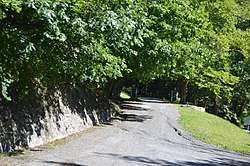 Three Hills |
December 24, 2013 (#13000986) |
348 Three Hills Ln. 38°02′44″N 79°46′57″W |
Warm Springs | |
| 18 | Warm Springs and West Warm Springs Historic District | 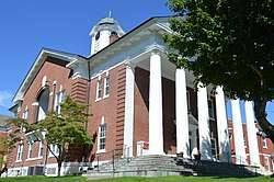 Warm Springs and West Warm Springs Historic District |
September 25, 2018 (#100002991) |
Junction of U.S. Route 220 and State Route 39, West Warm Springs Dr., and adjoining roads 38°02′46″N 79°47′22″W |
Warm Springs | |
| 19 | Warm Springs Bathhouses | 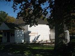 Warm Springs Bathhouses |
October 8, 1969 (#69000222) |
Northeast of Warm Springs off U.S. Route 220 38°03′13″N 79°46′50″W |
Warm Springs | Also known as Jefferson Pools; boundary increase approved August 20, 2019. |
| 20 | Warm Springs Mill | 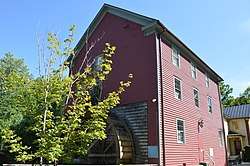 Warm Springs Mill |
September 11, 1989 (#88001448) |
Eastern side of Old Mill Rd. 38°02′53″N 79°47′24″W |
Warm Springs | |
| 21 | John Wesley Methodist Episcopal Church and Cemetery |  John Wesley Methodist Episcopal Church and Cemetery |
December 24, 2013 (#13000987) |
212 W. Warm Springs Dr. 38°03′34″N 79°48′23″W |
West Warm Springs | |
| 22 | The Wilderness | 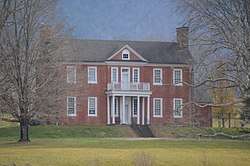 The Wilderness |
August 21, 2017 (#100001494) |
13954 Deerfield Rd. 38°08′10″N 79°29′18″W |
Hot Springs | |
| 23 | The Yard |  The Yard |
February 13, 2007 (#07000050) |
381 Old Greenhouse Rd. 37°59′32″N 79°50′05″W |
Hot Springs |
See also
| Wikimedia Commons has media related to National Register of Historic Places in Bath County, Virginia. |
References
- The latitude and longitude information provided in this table was derived originally from the National Register Information System, which has been found to be fairly accurate for about 99% of listings. Some locations in this table may have been corrected to current GPS standards.
- "National Register of Historic Places: Weekly List Actions". National Park Service, United States Department of the Interior. Retrieved on June 26, 2020.
- Numbers represent an ordering by significant words. Various colorings, defined here, differentiate National Historic Landmarks and historic districts from other NRHP buildings, structures, sites or objects.
- "National Register Information System". National Register of Historic Places. National Park Service. March 13, 2009.
- The eight-digit number below each date is the number assigned to each location in the National Register Information System database, which can be viewed by clicking the number.
- National Register of Historic Places Inventory/Nomination: Warm Springs Mill. National Park Service, 1988, 18.

Municipalities and communities of Bath County, Virginia, United States | ||
|---|---|---|
| CDPs | Map of Virginia highlighting Bath County | |
| Unincorporated communities |
| |
| Footnotes | ‡This populated place also has portions in an adjacent county or counties | |
This article is issued from Wikipedia. The text is licensed under Creative Commons - Attribution - Sharealike. Additional terms may apply for the media files.