National Register of Historic Places listings in Russell County, Virginia
This is a list of the National Register of Historic Places listings in Russell County, Virginia.
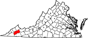
Location of Russell County in Virginia
This is intended to be a complete list of the properties and districts on the National Register of Historic Places in Russell County, Virginia, United States. The locations of National Register properties and districts for which the latitude and longitude coordinates are included below, may be seen in a Google map.[1]
There are 11 properties and districts listed on the National Register in the county.
- This National Park Service list is complete through NPS recent listings posted June 19, 2020.[2]
Current listings
| [3] | Name on the Register[4] | Image | Date listed[5] | Location | City or town | Description |
|---|---|---|---|---|---|---|
| 1 | Blackford Bridge | 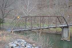 Blackford Bridge |
June 24, 2010 (#10000381) |
Chestnut Rd. 36°57′52″N 82°00′38″W |
Lebanon | |
| 2 | Carter Hill | 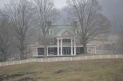 Carter Hill |
January 28, 2000 (#00000023) |
Fincastle Rd. 36°52′42″N 82°09′34″W |
Lebanon | |
| 3 | Castlerun Historic District | 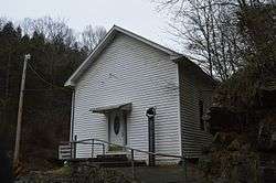 Castlerun Historic District |
January 28, 2000 (#00000024) |
Castle Run Rd. 36°51′03″N 82°18′51″W |
Castlewood | |
| 4 | Daugherty's Cave and Breeding Site | June 23, 1978 (#78003044) |
Address Restricted |
Lebanon | ||
| 5 | Samuel Gilmer House | 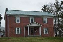 Samuel Gilmer House |
February 17, 2015 (#15000019) |
2410 E. Main St. 36°54′31″N 82°02′17″W |
Lebanon | |
| 6 | Honaker Commercial Historic District | 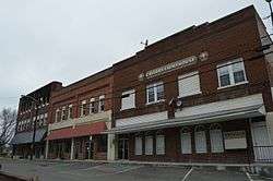 Honaker Commercial Historic District |
December 23, 2009 (#09001159) |
State Route 80 37°00′58″N 81°58′29″W |
Honaker | |
| 7 | Jessees Mill |  Jessees Mill |
January 20, 2005 (#04001543) |
Jessees Mill, 2.5 miles (4.0 km) north of State Route 71 36°54′50″N 82°10′04″W |
Cleveland | |
| 8 | Mason-Dorton School | 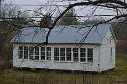 Mason-Dorton School |
May 3, 2002 (#02000450) |
State Route 71 at its junction with Moccasin Ridge Rd. 36°48′11″N 82°17′14″W |
Castlewood | |
| 9 | Old Russell County Courthouse | 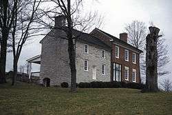 Old Russell County Courthouse |
July 16, 1973 (#73002059) |
West of Dickensonville on U.S. Route 58 Alternate 36°50′21″N 82°14′34″W |
Dickensonville | |
| 10 | Stephen B. Quillen House | 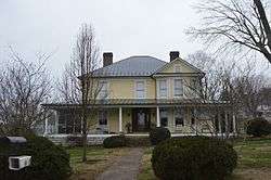 Stephen B. Quillen House |
October 23, 2003 (#03001096) |
149 Church St. 36°54′10″N 82°04′51″W |
Lebanon | |
| 11 | Smithfield | 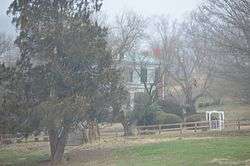 Smithfield |
August 16, 1994 (#94000988) |
Northwestern side of U.S. Route 19, 3 miles (4.8 km) southwest of Rosedale 36°56′31″N 81°57′48″W |
Rosedale |
See also
| Wikimedia Commons has media related to National Register of Historic Places in Russell County, Virginia. |
References
- The latitude and longitude information provided in this table was derived originally from the National Register Information System, which has been found to be fairly accurate for about 99% of listings. Some locations in this table may have been corrected to current GPS standards.
- "National Register of Historic Places: Weekly List Actions". National Park Service, United States Department of the Interior. Retrieved on June 19, 2020.
- Numbers represent an ordering by significant words. Various colorings, defined here, differentiate National Historic Landmarks and historic districts from other NRHP buildings, structures, sites or objects.
- "National Register Information System". National Register of Historic Places. National Park Service. April 24, 2008.
- The eight-digit number below each date is the number assigned to each location in the National Register Information System database, which can be viewed by clicking the number.

Municipalities and communities of Russell County, Virginia, United States | ||
|---|---|---|
| Towns | Map of Virginia highlighting Russell County | |
| CDPs | ||
| Unincorporated communities | ||
| Footnotes | ‡This populated place also has portions in an adjacent county or counties | |
This article is issued from Wikipedia. The text is licensed under Creative Commons - Attribution - Sharealike. Additional terms may apply for the media files.