Roche Percée
Roche Percée (2016 population: 110) is a village in the Canadian province of Saskatchewan within the Rural Municipality of Coalfields No. 4 and Census Division No. 1. The village is situated near the Canada–United States border just off of Highway 39. Roche Percée is 20 km (12 miles) east of Estevan in the valley of the Souris River.
Roche Percée | |
|---|---|
Village | |
 Roche Percée Location of Roche Percée  Roche Percée Roche Percée (Canada) | |
| Coordinates: 49°02′27″N 102°28′50″W | |
| Country | Canada |
| Province | Saskatchewan |
| Region | Saskatchewan |
| Rural Municipality | Coalfields No. 4 |
| Post Office Established | 1890 August 01 |
| Population (2006) | |
| • Total | 149 |
| Time zone | CST |
| Area code(s) | 306 |
| [1] | |
History
During the 1874 westward trek of the North-West Mounted Police, the force established its first camp (called Short Creek Camp) at this location. The community began being served by the SOO Line in 1893, permitting the coal mines in the region to become operational. Roche Percée incorporated as a village on January 12, 1909.[2]
In 2010, the provincial government signed an agreement with Southeast Tour & Trails Inc. to restore Roche Percée Park after being closed for over a decade.[3]
In 2011, flooding on the Souris River inundated the village, forcing its residents to evacuate.[4][5] 28 of the 64 homes in Roche Percee were damaged beyond repair, and had to be demolished.[6]
- Historical properties
Roche Percée Provincial Historic Site[7] is located nearby. Referred to by local residents as "The Rocks", it has large sandstone deposits in which some caves have formed. The name of the village comes from the Métis French name of the rock formations,[8] which means "pierced rock" in French. Another similar formation Rocher Percé is located in Quebec.
Roche Percée Gallery
 Plaque at Roche Percee
 Entry at Roche Percee
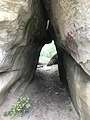 Cave at Roche Percee
 View from the top at Roche Percee
Demographics
In the 2016 Census of Population conducted by Statistics Canada, the Village of Roche Percée recorded a population of 110 living in 45 of its 50 total private dwellings, a -39.1% change from its 2011 population of 153. With a land area of 2.83 km2 (1.09 sq mi), it had a population density of 38.9/km2 (100.7/sq mi) in 2016.[11]
In the 2011 Census of Population, the Village of Roche Percée recorded a population of 153, a 2.7% change from its 2006 population of 149. With a land area of 2.83 km2 (1.09 sq mi), it had a population density of 54.1/km2 (140.0/sq mi) in 2011.[12]
See also
References
- "Roche Percée". Post Offices and Postmasters. Library and Archives Canada. January 31, 2007. Archived from the original on October 15, 2012. Retrieved 2011-06-21.
- "Urban Municipality Incorporations". Saskatchewan Ministry of Government Relations. Archived from the original on October 15, 2014. Retrieved June 1, 2020.
- Saxon, Chad (May 26, 2010). "Roche Percee Park plans moving forward". Estevan Mercury. Glacier Media Group. Retrieved 2011-06-21.
- Varano, Lisa (June 19, 2011). "Village underwater in Saskatchewan". The Weather Network. Retrieved 2011-06-20.
- "Tiny town submerged by Saskatchewan flood". CBC News. June 21, 2011. Retrieved 2011-06-21.
- "Five years after Roche Percee's epic flood, the village is looking to the future". Regina_Leader-Post. July 18, 2016. Retrieved 2019-07-28.
- "La Roche Percee Provincial Historic Site & Short Creek Cairn". Tourism Saskatchewan. Retrieved 2013-03-12.
- McLennan, David. "Roche Percée". Encyclopedia of Saskatchewan. Canadian Plains Research Center, University of Regina. Retrieved 2011-06-21.
- "Saskatchewan Census Population" (PDF). Saskatchewan Bureau of Statistics. Archived from the original (PDF) on September 24, 2015. Retrieved May 31, 2020.
- "Saskatchewan Census Population". Saskatchewan Bureau of Statistics. Retrieved May 31, 2020.
- "Population and dwelling counts, for Canada, provinces and territories, and census subdivisions (municipalities), 2016 and 2011 censuses – 100% data (Saskatchewan)". Statistics Canada. February 8, 2017. Retrieved May 30, 2020.
- "Population and dwelling counts, for Canada, provinces and territories, and census subdivisions (municipalities), 2011 and 2006 censuses (Saskatchewan)". Statistics Canada. June 3, 2019. Retrieved May 30, 2020.
| Cities | 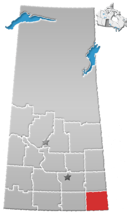 | ||||
|---|---|---|---|---|---|
| Towns | |||||
| Villages | |||||
| Rural municipalities | |||||
| First Nations |
| ||||
| Indian reserves | |||||
| Unincorporated communities |
| ||||