Frobisher, Saskatchewan
Frobisher (2016 population: 160) is a village in the Canadian province of Saskatchewan within the Rural Municipality of Coalfields No. 4 and Census Division No. 1.
Frobisher | |
|---|---|
| Village of Frobisher | |
 Frobisher Location of Frobisher in Saskatchewan  Frobisher Frobisher (Canada) | |
| Coordinates: 49.200°N 102.450°W | |
| Country | |
| Province | |
| Region | Southeast |
| Census division | 1 |
| Rural Municipality | Coalfields No. 4 |
| Post office Founded | 1902-02-01 |
| Government | |
| • Type | Municipal |
| • Governing body | Frobisher Village Council |
| • Mayor | Keith Newsham |
| • Administrator | Valerie Pelton |
| • MLA | Dan D'Autremont |
| • MP | Robert Kitchen |
| Area | |
| • Total | 1.35 km2 (0.52 sq mi) |
| Population (2016) | |
| • Total | 160 |
| • Density | 118.5/km2 (307/sq mi) |
| Time zone | UTC-6 (CST) |
| Postal code | S0C 0Y0 |
| Area code(s) | 306 |
| Highways | |
| [1][2][3][4] | |
History
Frobisher incorporated as a village on July 4, 1904.[5]
Demographics
In the 2016 Census of Population conducted by Statistics Canada, the Village of Frobisher recorded a population of 160 living in 65 of its 88 total private dwellings, a -3.8% change from its 2011 population of 166. With a land area of 1.35 km2 (0.52 sq mi), it had a population density of 118.5/km2 (307.0/sq mi) in 2016.[8]
In the 2011 Census of Population, the Village of Frobisher recorded a population of 166, a 14.5% change from its 2006 population of 145. With a land area of 1.35 km2 (0.52 sq mi), it had a population density of 123.0/km2 (318.5/sq mi) in 2011.[9]
See also
- List of communities in Saskatchewan
- Villages of Saskatchewan
References
- National Archives, Archivia Net. "Post Offices and Postmasters". Archived from the original on 2006-10-06. Retrieved 2014-08-21.
- Government of Saskatchewan, MRD Home. "Municipal Directory System". Archived from the original on 2016-01-15. Retrieved 2014-08-21.
- Canadian Textiles Institute. (2005), CTI Determine your provincial constituency, archived from the original on 2007-09-11
- Commissioner of Canada Elections, Chief Electoral Officer of Canada (2005), Elections Canada On-line, archived from the original on 2007-04-21
- "Urban Municipality Incorporations". Saskatchewan Ministry of Government Relations. Archived from the original on October 15, 2014. Retrieved June 1, 2020.
- "Saskatchewan Census Population" (PDF). Saskatchewan Bureau of Statistics. Archived from the original (PDF) on September 24, 2015. Retrieved May 31, 2020.
- "Saskatchewan Census Population". Saskatchewan Bureau of Statistics. Retrieved May 31, 2020.
- "Population and dwelling counts, for Canada, provinces and territories, and census subdivisions (municipalities), 2016 and 2011 censuses – 100% data (Saskatchewan)". Statistics Canada. February 8, 2017. Retrieved May 30, 2020.
- "Population and dwelling counts, for Canada, provinces and territories, and census subdivisions (municipalities), 2011 and 2006 censuses (Saskatchewan)". Statistics Canada. June 3, 2019. Retrieved May 30, 2020.
| Cities | 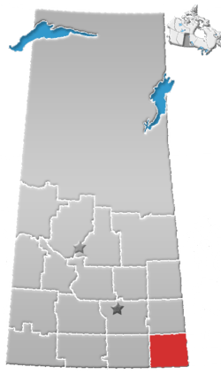 | ||||
|---|---|---|---|---|---|
| Towns | |||||
| Villages | |||||
| Rural municipalities | |||||
| First Nations |
| ||||
| Indian reserves | |||||
| Unincorporated communities |
| ||||