Provinces and territories of Canada
The provinces and territories of Canada are sub-national divisions within the geographical areas of Canada under the jurisdiction of the Canadian Constitution. In the 1867 Canadian Confederation, three provinces of British North America—New Brunswick, Nova Scotia, and the Province of Canada (which upon Confederation was divided into Ontario and Quebec)—were united to form a federated colony, becoming a sovereign nation in the next century. Over its history, Canada's international borders have changed several times, and the country has grown from the original four provinces to the current ten provinces and three territories. Together, the provinces and territories make up the world's second-largest country by total area.
| Provinces and territories of Canada | |
|---|---|
 | |
| Category | Federated state |
| Number | 10 provinces 3 territories |
The major difference between a Canadian province and a territory is that provinces receive their power and authority from the Constitution Act, 1867 (formerly[1] called The British North America Act, 1867), whereas territorial governments have powers delegated to them by the Parliament of Canada. The powers flowing from the Constitution Act are divided between the Government of Canada (the federal government) and the provincial governments to exercise exclusively. A change to the division of powers between the federal government and the provinces requires a constitutional amendment, whereas a similar change affecting the territories can be performed unilaterally by the Parliament of Canada or government.
In modern Canadian constitutional theory, the provinces are considered sovereign within certain areas based on the divisions of responsibility between the provincial and federal government within the Constitution Act 1867, and each province thus has its own representative of the Canadian "Crown", the lieutenant governor. The territories are not sovereign, but instead their authorities and responsibilities come directly from the federal level, and as a result, have a commissioner instead of a lieutenant governor.
Provinces
| Arms | Province | Postal abbrev. |
Capital [2] |
Largest city[3] |
Entered Confederation[4] |
Population [lower-alpha 1] |
Area (km2)[6] | Official language(s)[7] |
Seats[8] | |||
|---|---|---|---|---|---|---|---|---|---|---|---|---|
| Land | Water | Total | Commons | Senate | ||||||||
| ON | Toronto | July 1, 1867 | 14,745,040 | 917,741 | 158,654 | 1,076,395 | English[lower-alpha 3] | 121 | 24 | |||
| QC | Quebec City | Montreal | July 1, 1867 | 8,552,362 | 1,356,128 | 185,928 | 1,542,056 | French[lower-alpha 4] | 78 | 24 | ||
| NS | Halifax[lower-alpha 5] | July 1, 1867 | 978,274 | 53,338 | 1,946 | 55,284 | English[lower-alpha 6] | 11 | 10 | |||
| NB | Fredericton | Moncton | July 1, 1867 | 780,890 | 71,450 | 1,458 | 72,908 | English French[lower-alpha 7] |
10 | 10 | ||
| MB | Winnipeg | July 15, 1870 | 1,379,121 | 553,556 | 94,241 | 647,797 | English[lower-alpha 3][lower-alpha 8] | 14 | 6 | |||
| BC | Victoria | Vancouver | July 20, 1871 | 5,120,184 | 925,186 | 19,549 | 944,735 | English[lower-alpha 3] | 42 | 6 | ||
| PE | Charlottetown | July 1, 1873 | 158,717 | 5,660 | 0 | 5,660 | English[lower-alpha 3] | 4 | 4 | |||
| SK | Regina | Saskatoon | September 1, 1905 | 1,181,987 | 591,670 | 59,366 | 651,036 | English[lower-alpha 3] | 14 | 6 | ||
| AB | Edmonton | Calgary | September 1, 1905 | 4,428,247 | 642,317 | 19,531 | 661,848 | English[lower-alpha 3] | 34 | 6 | ||
| NL | St. John's | March 31, 1949 | 520,437 | 373,872 | 31,340 | 405,212 | English[lower-alpha 3] | 7 | 6 | |||
| Total provinces | 37,672,706 | 5,490,918 | 572,013 | 6,062,931 | — | 335 | 102 | |||||
Notes:
- As of Q2 2020.[5]
- Ottawa, the national capital of Canada, is located in Ontario, near its border with Quebec. However, the National Capital Region straddles the border.
- De facto; French has limited constitutional status.
- Charter of the French Language; English has limited constitutional status.
- Nova Scotia dissolved cities in 1996 in favour of regional municipalities; its largest regional municipality is therefore substituted.
- Nova Scotia has very few bilingual statutes (three in English and French; one in English and Polish); some Government bodies have legislated names in both English and French.
- Section Sixteen of the Canadian Charter of Rights and Freedoms.
- Although the province has above average constitutional protections for the French language it is still not an official language .
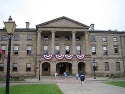
Provincial legislature buildings
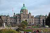


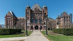
.jpg)
%2C_St._John's%2C_Newfoundland%2C_Canada.jpg)
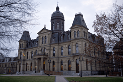
.jpg)
Territories
There are three territories in Canada. Unlike the provinces, the territories of Canada have no inherent sovereignty and have only those powers delegated to them by the federal government.[9][10][11] They include all of mainland Canada north of latitude 60° north and west of Hudson Bay and all islands north of the Canadian mainland (from those in James Bay to the Queen Elizabeth Islands). The following table lists the territories in order of precedence (each province has precedence over all the territories, regardless of the date each territory was created).
| Arms | Territory | Postal abbreviation |
Capital and largest city[2] |
Entered Confederation[4] |
Population[lower-alpha 1] | Area (km2)[6] | Official languages | Seats[8] | |||
|---|---|---|---|---|---|---|---|---|---|---|---|
| Land | Water | Total | Commons | Senate | |||||||
| NT | Yellowknife | July 15, 1870 | 44,982 | 1,183,085 | 163,021 | 1,346,106 | Chipewyan, Cree, English, French, Gwich'in, Inuinnaqtun, Inuktitut, Inuvialuktun, North Slavey, South Slavey, Tłįchǫ[12] | 1 | 1 | ||
| YT | Whitehorse | June 13, 1898 | 41,293 | 474,391 | 8,052 | 482,443 | English, French[13] | 1 | 1 | ||
| NU | Iqaluit | April 1, 1999 | 39,486 | 1,936,113 | 157,077 | 2,093,190 | Inuinnaqtun, Inuktitut, English, French[14] | 1 | 1 | ||
| Total territories | 125,079 | 3,593,589 | 328,150 | 3,921,739 | — | 3 | 3 | ||||
- As of Q2 2020.[5]
Territorial legislature buildings


Population

The majority of Canada's population is concentrated in the areas close to the Canada–US border. Its four largest provinces by area (Quebec, Ontario, British Columbia and Alberta) are also (with Quebec and Ontario, switched in order) its most populous; together they account for 86% of the country's population. The territories (the Northwest Territories, Nunavut and Yukon) account for over a third of Canada's area but are home to only 0.3% of its population, which skews the national population density value.[15]
Canada's population grew by 5.0% between the 2006 and 2011 censuses. Except for New Brunswick, all territories and provinces increased in population from 2011 to 2016. In terms of percent change, the fastest-growing province or territory was Nunavut with an increase of 12.7% between 2011 and 2016, followed by Alberta with 11.6% growth. New Brunswick's population decreased by 0.5% between 2011 and 2016.[16]
Generally, Canadian Provinces steadily grew in population along with Canada. However, some provinces such as Saskatchewan, Prince Edward Island and Newfoundland and Labrador experienced long periods of stagnation or population decline. Ontario and Quebec were always the two biggest provinces in Canada, with over 60% of the population to themselves at any given time. The demographic importance of the West steadily grew over time, while the importance of Atlantic Canada steadily slipped.[15]
Territorial evolution
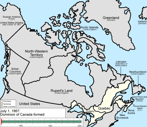
Ontario, Quebec, New Brunswick, and Nova Scotia were the original provinces, formed when several British North American colonies federated on July 1, 1867, into the Dominion of Canada and by stages began accruing the indicia of sovereignty from the United Kingdom.[17] Prior to this, Ontario and Quebec were united as the Province of Canada. Over the following years, Manitoba (1870), British Columbia (1871), and Prince Edward Island (1873) were added as provinces.[17]
The British Crown had claimed two large areas north-west of the Canadian colony, known as Rupert's Land and the North-Western Territory, and assigned them to the Hudson's Bay Company. In 1870, the company relinquished its claims for £300,000 ($1.5 million), assigning the vast territory to the Government of Canada.[18] Subsequently, the area was re-organized into the province of Manitoba and the Northwest Territories.[18] The Northwest Territories were vast at first, encompassing all of current northern and western Canada, except for the British holdings in the Arctic islands and the Colony of British Columbia; the Territories also included the northern two-thirds of Ontario and Quebec, and almost all of present Manitoba, with the 1870 province of Manitoba originally being confined to a small area in the south of today's province.[19] The British claims to the Arctic islands were transferred to Canada in 1880, adding to the size of the Northwest Territories. The year of 1898 saw the Yukon Territory, later renamed simply as Yukon, carved from the parts of the Northwest Territories surrounding the Klondike gold fields. On September 1, 1905, a portion of the Northwest Territories south of the 60th parallel north became the provinces of Alberta and Saskatchewan.[19] In 1912, the boundaries of Quebec, Ontario, and Manitoba were expanded northward: Manitoba's to the 60° parallel, Ontario's to Hudson Bay and Quebec's to encompass the District of Ungava.[20]
In 1869, the people of Newfoundland voted to remain a British colony over fears that taxes would increase with Confederation, and that the economic policy of the Canadian government would favour mainland industries.[21] In 1907, Newfoundland acquired dominion status.[22] In the middle of the Great Depression in Canada with Newfoundland facing a prolonged period of economic crisis, the legislature turned over political control to the Newfoundland Commission of Government in 1933.[23] Following Canada's participation in World War II, in a 1948 referendum, a narrow majority of Newfoundland citizens voted to join the Confederation, and on March 31, 1949, Newfoundland became Canada's tenth province.[24] In 2001, it was officially renamed Newfoundland and Labrador.[25]
In 1903, the Alaska Panhandle Dispute fixed British Columbia's northwestern boundary.[26] This was one of only two provinces in Canadian history to have its size reduced. The second reduction, in 1927, occurred when a boundary dispute between Canada and the Dominion of Newfoundland saw Labrador increased at Quebec's expense – this land returned to Canada, as part of the province of Newfoundland, in 1949.[27] In 1999, Nunavut was created from the eastern portion of the Northwest Territories.[28] Yukon lies in the western portion of Northern Canada, while Nunavut is in the east.[29]
All three territories combined are the most sparsely populated region in Canada, covering 3,921,739 km2 (1,514,192 sq mi) in land area.[6] They are often referred to as a single region, The North, for organisational and economic purposes.[30] For much of the Northwest Territories' early history it was divided into several districts for ease of administration.[31] The District of Keewatin was created as a separate territory from 1876 to 1905, after which, as the Keewatin Region, it became an administrative district of the Northwest Territories.[32] In 1999, it was dissolved when it became part of Nunavut.
Government
Theoretically, provinces have a great deal of power relative to the federal government, with jurisdiction over many public goods such as health care, education, welfare, and intra-provincial transportation.[33] They receive "transfer payments" from the federal government to pay for these, as well as exacting their own taxes.[34] In practice, however, the federal government can use these transfer payments to influence these provincial areas. For instance, in order to receive healthcare funding under Medicare, provinces must agree to meet certain federal mandates, such as universal access to required medical treatment.[34]
Provincial and territorial legislatures have no second chamber like the Canadian Senate. Originally, most provinces had such bodies, known as legislative councils, with members titled councillors. These upper houses were abolished one by one, Quebec's being the last in 1968.[35] In most provinces, the single house of the legislature is known as the Legislative Assembly; the exceptions are Nova Scotia and Newfoundland and Labrador, where the chamber is called the House of Assembly, and Quebec where it is called the National Assembly.[36] Ontario has a Legislative Assembly but its members are called Members of the Provincial Parliament or MPPs.[37] The legislative assemblies use a procedure similar to that of the House of Commons of Canada. The head of government of each province, called the premier, is generally the head of the party with the most seats.[38] This is also the case in Yukon, but the Northwest Territories and Nunavut have no political parties at the territorial level.[39] The Queen's representative in each province is the Lieutenant Governor.[40] In each of the territories there is an analogous Commissioner, but they represent the federal government rather than the monarch.[41]
| Jurisdiction | Legislature | Lower house | Members of lower house | Head of Government | Viceroy |
|---|---|---|---|---|---|
| Canada | Parliament | House of Commons | Member of Parliament | Prime Minister | Governor General |
| Ontario | Legislative Assembly | Member of the Provincial Parliament* | Premier | Lieutenant Governor | |
| Quebec | Legislature | National Assembly† | Member of the National Assembly† | ||
| Nova Scotia | General Assembly | House of Assembly | Member of the Legislative Assembly§ | ||
| New Brunswick | Legislature | Legislative Assembly§ | |||
| Manitoba | |||||
| British Columbia | Parliament | ||||
| Prince Edward Island | General Assembly | ||||
| Saskatchewan | Legislature | ||||
| Alberta | |||||
| Newfoundland and Labrador |
General Assembly | House of Assembly | Member of the House of Assembly | ||
| Northwest Territories | Assembly | Legislative Assembly | Member of the Legislative Assembly | Premier‖ | Commissioner |
| Yukon | Legislature | ||||
| Nunavut | Assembly |
* Members were previously titled "Member of the Legislative Assembly".
† Quebec's lower house was previously called the "Legislative Assembly" with members titled "Member of the Legislative Assembly". The name was changed at the same time Quebec's upper house was abolished.
§ Prince Edward Island's lower house was previously called the "House of Assembly" and its members were titled "Assemblyman". After abolition of its upper house, assemblymen and councillors both sat in the renamed "Legislative Assembly". Later, this practice was abolished so that all members would be titled "Member of the Legislative Assembly".
‖ In Northwest Territories and Yukon the head of government was previously titled "Government Leader".
Provincial political parties
Most provinces have rough provincial counterparts to major federal parties. However, these provincial parties are not usually formally linked to the federal parties that share the same name.[42] For example, no provincial Conservative or Progressive Conservative Party shares an organizational link to the federal Conservative Party of Canada, and neither do provincial Green Parties to the Green Party of Canada. Provincial New Democratic Parties, on the other hand, are fully integrated with the federal New Democratic Party – meaning that provincial parties effectively operate as sections, with common membership, of the federal party. The Liberal Party of Canada shares such an organizational integration with the provincial Liberals in New Brunswick, Newfoundland and Labrador, Nova Scotia, and Prince Edward Island. Other provincial Liberal Parties are unaffiliated with their federal counterpart.[42]
Some provinces have provincial political parties with no clear federal equivalent, such as the Alberta Party and Saskatchewan Party.
The provincial political climate of Quebec is different: the main split is between sovereignty, represented by the Parti Québécois and Québec solidaire, and federalism, represented primarily by the Quebec Liberal Party.[43] The Coalition Avenir Québec, meanwhile, takes an abstentionist position on the question and does not support or oppose sovereignty.
Currently, the three minority provincial/territorial governments are held by the NDP in British Columbia, the PCs in New Brunswick, and the PCs in Prince Edward Island
 The governing political party(s) in each Canadian province. Multicoloured provinces are governed by a coalition or minority government consisting of more than one party.
 The governing political party(s) in each Canadian province by political position
Ceremonial territory

The Canadian National Vimy Memorial, near Vimy, Pas-de-Calais, and the Beaumont-Hamel Newfoundland Memorial, near Beaumont-Hamel, both in France, are ceremonially considered Canadian territory.[58] In 1922, the French government donated the land used for the Vimy Memorial "freely, and for all time, to the Government of Canada the free use of the land exempt from all taxes".[59] The site of the Somme battlefield near Beaumont-Hamel site was purchased in 1921 by the people of the Dominion of Newfoundland.[58] These sites do not, however, enjoy extraterritorial status and are thus subject to French law.
Proposed provinces and territories
Since Confederation in 1867, there have been several proposals for new Canadian provinces and territories. The Constitution of Canada requires an amendment for the creation of a new province[60] but the creation of a new territory requires only an act of Parliament, a legislatively simpler process.[61]
In late 2004, Prime Minister Paul Martin surprised some observers by expressing his personal support for all three territories gaining provincial status "eventually". He cited their importance to the country as a whole and the ongoing need to assert sovereignty in the Arctic, particularly as global warming could make that region more open to exploitation leading to more complex international waters disputes.[62]
See also
- Canadian provincial and territorial name etymologies
- Canadian adjectival and demonymic forms of place names
- Language policies of Canada's provinces and territories
- List of areas disputed by Canada and the United States
- List of regions of Canada
- List of governments in Canada by annual expenditures
- Commonwealth Local Government Forum-Americas
- Provincial museums of Canada
- List of Canada-related topics by provinces and territories

References
- Name changed only in Canada by Canada Act, 1982 (UK), s. 1--see Talk
- "Provinces and Territories". Government of Canada. 2013. Archived from the original on February 9, 2010. Retrieved August 6, 2013.
- Place name (2013). "Census Profile". Statistic Canada. Archived from the original on February 8, 2013. Retrieved August 6, 2013.
- Reader's Digest Association (Canada); Canadian Geographic Enterprises (2004). The Canadian Atlas: Our Nation, Environment and People. Douglas & McIntyre. p. 41. ISBN 978-1-55365-082-9. Archived from the original on May 3, 2016. Retrieved November 21, 2015.
- "Population estimates, quarterly". Statistics Canada. March 20, 2020. Archived from the original on January 9, 2019. Retrieved March 20, 2020.
- "Land and freshwater area, by province and territory". Statistics Canada. 2005. Archived from the original on May 24, 2011. Retrieved August 4, 2013.
- Coche, Olivier; Vaillancourt, François; Cadieux, Marc-Antoine; Ronson, Jamie Lee (2012). "Official Language Policies of the Canadian Provinces" (PDF). Fraser Institute. Archived from the original (PDF) on April 28, 2012. Retrieved August 6, 2012.
- "Guide to the Canadian House of Commons". Parliament of Canada. 2012. Archived from the original on June 27, 2013. Retrieved August 6, 2013.
- "Northwest Territories Act". Department of Justice Canada. 1986. Archived from the original on May 15, 2013. Retrieved March 25, 2013.
- "Yukon Act". Department of Justice Canada. 2002. Archived from the original on May 28, 2013. Retrieved March 25, 2013.
- Department of Justice Canada (1993). "Nunavut Act". Archived from the original on January 5, 2011. Retrieved January 27, 2007.
- Northwest Territories Official Languages Act, 1988 Archived July 22, 2014, at the Wayback Machine (as amended 1988, 1991–1992, 2003)
- "OCOL – Statistics on Official Languages in Yukon". Office of the Commissioner of Official Languages. 2011. Archived from the original on July 25, 2013. Retrieved August 6, 2013.
- "Nunavut's Official Languages". Language Commissioner of Nunavut. 2009. Archived from the original on August 14, 2013. Retrieved August 6, 2013.
- Series A2-14. Population of Canada by province, census dates, 1851 to 1976
- "2016 Census profiles". Statistics Canada. 2016.
- Ajzenstat, Janet (2003). Canada's Founding Debates. University of Toronto Press. p. 3. ISBN 978-0-8020-8607-5. Archived from the original on April 24, 2016. Retrieved November 22, 2015.
- Olson, James Stuart; Shadle, Robert (1996). Historical Dictionary of the British Empire: A-J. Greenwood Publishing Group. p. 538. ISBN 978-0-313-29366-5. Archived from the original on May 6, 2016. Retrieved November 22, 2015.
- Gough, Barry M. (2010). Historical Dictionary of Canada. Wilfrid Laurier University. pp. 141–142. ISBN 978-0-8108-7504-3. Archived from the original on May 29, 2016. Retrieved November 22, 2015.CS1 maint: ref=harv (link)
- Atlas of Canada. "Territorial evolution". Archived from the original on February 2, 2007. Retrieved January 27, 2007.
- "Confederation Rejected: Newfoundland and the Canadian Confederation, 1864–1869: Newfoundland and Labrador Heritage". Newfoundland and Labrador Heritage. 2000. Archived from the original on September 22, 2013. Retrieved July 29, 2013.
- Clarke, Sandra (2010). Newfoundland and Labrador English. Edinburgh University Press. p. 7. ISBN 978-0-7486-2617-5. Archived from the original on May 12, 2016. Retrieved November 22, 2015.
- Friesen, John W.; Harrison, Trevor W. (2010). Canadian Society in the Twenty-first Century: An Historical Sociological Approach. Canadian Scholars' Press. p. 115. ISBN 978-1-55130-371-0. Archived from the original on April 29, 2016. Retrieved November 22, 2015.
- Blake, Raymond Benjamin (1994). Canadians at Last: Canada Integrates Newfoundland As a Province. University of Toronto Press. p. 4. ISBN 978-0-8020-6978-8. Archived from the original on June 23, 2016. Retrieved November 22, 2015.
- Shelley, Fred M. (2013). Nation Shapes: The Story behind the World's Borders. ABC-CLIO. p. 175. ISBN 978-1-61069-106-2. Archived from the original on April 28, 2016. Retrieved November 22, 2015.
- Laxer, James (2010). The Border: Canada, the US and Dispatches From the 49th Parallel. Doubleday Canada. p. 215. ISBN 978-0-385-67290-0. Archived from the original on April 30, 2016. Retrieved November 22, 2015.
- Cukwurah, A. Oye (1967). The Settlement of Boundary Disputes in International Law. Manchester University Press. p. 186. GGKEY:EXSJZ7S92QE. Archived from the original on May 19, 2016. Retrieved November 22, 2015.
- Atkinson, Michael M.; Marchildon, Gregory P.; Phillips, Peter W. B.; Béland, Daniel; Rasmussen, Kenneth A.; McNutt, Kathleen (2013). Governance and Public Policy in Canada: A View from the Provinces. University of Toronto Press. p. 19. ISBN 978-1-4426-0493-3. Archived from the original on May 6, 2016. Retrieved November 22, 2015.
- Nuttall, Mark (2012). Encyclopedia of the Arctic. Routledge. p. 301. ISBN 978-1-57958-436-8. Archived from the original on May 6, 2016. Retrieved November 22, 2015.
- Organisation for Economic Co-operation and Development (2002). Oecd Territorial Reviews: Canada. OECD Publishing. p. 16. ISBN 978-92-64-19832-6. Retrieved November 22, 2015.
- Waldman, Carl; Braun, Molly (2009). Atlas of the North American Indian. Infobase Publishing. p. 234. ISBN 978-1-4381-2671-5. Archived from the original on May 16, 2016. Retrieved November 22, 2015.
- McIlwraith, Thomas Forsyth; Muller, Edward K. (2001). North America: The Historical Geography of a Changing Continent. Rowman & Littlefield. p. 359. ISBN 978-0-7425-0019-8. Archived from the original on May 6, 2016. Retrieved November 22, 2015.
- Mahler, Gregory S. (1987). New Dimensions of Canadian Federalism: Canada in a Comparative Perspective. Fairleigh Dickinson Univ Press. p. 86. ISBN 978-0-8386-3289-5. Retrieved November 22, 2015.
- Peach, Ian (2007). Constructing Tomorrows Federalism: New Perspectives on Canadian Governance. Univ. of Manitoba Press. p. 52. ISBN 978-0-88755-315-8. Archived from the original on May 10, 2016. Retrieved November 22, 2015.
- Maclure, Jocelyn (2003). Quebec Identity: The Challenge of Pluralism. McGill-Queen's Press – MQUP. p. 162. ISBN 978-0-7735-7111-2. Archived from the original on May 1, 2016. Retrieved November 22, 2015.
- Tidridge, Nathan (2011). Canada's Constitutional Monarchy: An Introduction to Our Form of Government. Dundurn. p. 281. ISBN 978-1-4597-0084-0. Archived from the original on May 14, 2016. Retrieved November 22, 2015.
- Pinto, Laura Elizabeth (2012). Curriculum Reform in Ontario: 'Common-Sense' Policy Processes and Democratic Possibilities. University of Toronto Press. p. 325. ISBN 978-1-4426-6158-5. Archived from the original on May 29, 2016. Retrieved November 22, 2015.
- Barnhart, Gordon (2004). Saskatchewan Premiers of the Twentieth Century. University of Regina Press. p. 7. ISBN 978-0-88977-164-2. Archived from the original on May 27, 2016. Retrieved November 22, 2015.
- Zellen, Barry Scott (2009). On Thin Ice: The Inuit, the State, and the Challenge of Arctic Sovereignty. Lexington Books. p. 54. ISBN 978-0-7391-3280-7. Archived from the original on April 30, 2016. Retrieved November 22, 2015.
- Tidridge, Nathan (2011). Canada's Constitutional Monarchy. Dundurn. p. 94. ISBN 978-1-55488-980-8. Archived from the original on June 17, 2016. Retrieved November 22, 2015.
- Pike, Corinna; McCreery, Christopher (2011). Canadian Symbols of Authority: Maces, Chains, and Rods of Office. Dundurn. p. 183. ISBN 978-1-4597-0016-1. Archived from the original on May 29, 2016. Retrieved November 22, 2015.
- Cross, William (2011). Political Parties. UBC Press. pp. 17–20. ISBN 978-0-7748-4111-5.
- Gagnon, Alain-Gustave (2000). The Canadian Social Union Without Quebec: 8 Critical Analyses. IRPP. pp. 209–210. ISBN 978-0-88645-184-4. Archived from the original on May 5, 2016. Retrieved November 22, 2015.
- "Premiers". Parliament of Canada. Retrieved August 6, 2013.
- "Lieutenant Governors and Territorial Commissioners". Parliament of Canada. Retrieved August 6, 2013.
- "Canada: Jason Kenney and United Conservatives win Alberta election". The Guardian. The Guardian. April 17, 2019.
- "Jason Kenney rides UCP wave to majority government in Alberta". CBC. CBC.
- Magnusson, Warren; Shaw, Karena (2003). A Political Space: Reading the Global Through Clayoquot Sound. U of Minnesota Press. p. 18. ISBN 978-0-8166-4039-3.
- Susan Lee Kang (2008). Contestation and Collectivies: Protecting Labor Organizing Rights in the Global Economy. ProQuest. p. 315. ISBN 978-0-549-63283-2. Retrieved May 7, 2013.
- Brian Gallant's minority government defeated after losing confidence vote
- The Canadian Press; The Chronicle Herald. Liberal Premier Stephen McNeil: Nova Scotia's soft-spoken fiscal hawk.
- Philip Authier, "Inside the CAQ cabinet: François Legault names 13 women, 13 men," Montreal Gazette, October 18, 2018.
- "Meet the key cabinet ministers in the new Coalition Avenir Québec government", CBC News, October 18, 2018.
- Randy Boswell; Saskatoon StarPhoenix and Regina Leader-Post; Lynn McAuley (January 1, 2005). Province with a Heart: Celebrating 100 Years in Saskatchewan. CanWest Books. p. 205. ISBN 978-0-9736719-0-2.
- Linda Trimble; Jane Arscott; Manon Tremblay (May 31, 2013). Stalled: The Representation of Women in Canadian Governments. UBC Press. p. 220. ISBN 978-0-7748-2522-1.
- Encyclopædia Britannica, Inc. (March 1, 2012). Britannica Book of the Year 2012. Encyclopædia Britannica, Inc. p. 378. ISBN 978-1-61535-618-8.
- Charles S. Mack (2010). When Political Parties Die: A Cross-national Analysis of Disalignment and Realignment. ABC-CLIO. p. 225. ISBN 978-0-313-38546-9.
- Wilson, John (2012). Failed Hope: The Story of the Lost Peace. Dundurn. p. 38. ISBN 978-1-4597-0345-2. Retrieved November 22, 2015.
- "Design and Construction of the Vimy Ridge Memorial". Veteran Affairs Canada. August 8, 1998. Archived from the original on April 9, 2009. Retrieved July 20, 2007.
- An amendment to the Constitution of Canada in relation to the following matters may be made only in accordance with subsection 38(1)...notwithstanding any other law or practice, the establishment of new provinces.
- Nicholson, Norman L. (1979). The boundaries of the Canadian Confederation. McGill-Queen's Press – MQUP. pp. 174–175. ISBN 978-0-7705-1742-7. Archived from the original on June 24, 2016. Retrieved November 22, 2015.
- "Northern territories 'eventually' to be given provincial status". CBC News. November 23, 2004. Archived from the original on February 25, 2007. Retrieved January 27, 2007.
Further reading
- Brownsey, Keith; Howlett, Michael (2001). The Provincial State in Canada: Politics in the Provinces and Territories. University of Toronto Press. ISBN 978-1-55111-368-5.
- Moore, Christopher; Slavin, Bill; Lunn, Janet (2002). The Big Book of Canada: Exploring the Provinces and Territories. Random House Digital, Inc. ISBN 978-0-88776-457-8.
- Pross, A. Paul; Pross, Catherine A. (1972). Government Publishing in the Canadian Provinces: a Prescriptive Study. Toronto, Ont.: University of Toronto Press. ISBN 0-8020-1827-0.
- Tomblin, Stephen (1995). Ottawa and the Outer Provinces: The Challenge of Regional Integration in Canada. James Lorimer & Company. ISBN 978-1-55028-476-8.
External links
- Provincial and territorial government web sites – Service Canada
- Provincial and territorial legislature web sites – Parliament of Canada
- Difference between provinces and territories – Intergovernmental Affairs
- Provincial and territorial statistics – Statistics Canada
- Provincial and territorial immigration information – Citizenship and Immigration Canada
- Canadian governments compared – University of Public Administration
| |||||||||||||
| Authority control |
|
|---|