Gainsborough, Saskatchewan
Gainsborough (2016 population: 254) is a village in the Canadian province of Saskatchewan within the Rural Municipality of Argyle No. 1 and Census Division No. 1. A farming community, the village is located on Highway 18 in the southeastern corner of Saskatchewan. Gainsborough is approximately 6 km (3.7 mi) from the Manitoba border, and 19 km (12 mi) from the North Dakota, United States border.
Gainsborough | |
|---|---|
| Village of Gainsborough | |
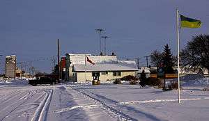 2011 image from viewpoint of 1978 painting "40 Below Zero" by William G. Hobbs. | |
| Motto(s): First incorporated village in Saskatchewan | |
 Gainsborough  Gainsborough | |
| Coordinates: 49°10′34″N 101°27′30″W | |
| Country | |
| Province | |
| Region | Southeast |
| Census division | 1 |
| Rural Municipality | Argyle No. 1 |
| Post office Founded | 1884-04-01 |
| Incorporated (Village) | 1882 (1st. incorporated village in Saskatchewan) |
| Government | |
| • Type | Municipal |
| • Governing body | Gainsborough Village Council |
| • Mayor | Victor Huish |
| • Administrator | Erin McMillen |
| • MP | Robert Kitchen |
| • MLA | Dan D'Autremont |
| Area | |
| • Total | 1.95 km2 (0.75 sq mi) |
| Population (2016) | |
| • Total | 286 |
| Time zone | UTC-6 (CST) |
| Postal code | S0C 0Z0 |
| Area code(s) | 306 |
| Highways | |
| Railways | Canadian Pacific Railway |
Name
The first post-office was established on April 1, 1884 as the community of Antler; on September 1, 1885 the name of the community changed to Gainsborough.[1]
The village is named after Gainsborough, Lincolnshire in England, former home of J. J. Sadler, early settler.[2]
There is also a Gainsborough in the English county of Lincolnshire. There is also a Gainsborough in New South Wales in Australia.
Location
8 miles east is the community of Pierson, Manitoba. To the west 8 miles is the village of Carievale. 16 miles straight north of Gainsborough is the hamlet of Fertile. The closest communities to the south are Antler and Sherwood, North Dakota. Nearby towns to the north and west are Storthoaks, Carnduff, Glen Ewen, Oxbow and Bellegarde, while to the east are Lyleton, Tilston and Melita, Manitoba. The nearest population centers with more than 10,000 people are approximately an hour's drive away: Estevan, which is westward on Highway 18, and Minot, North Dakota is a 75-minute drive almost directly south. Brandon is a 2-hour drive away, while Regina, Saskatchewan and Winnipeg each approximately 3.0-3.5 hours away by car.
Antler is the closest border crossing station between Canada and the US, and like most small posts on the frontier it is closed overnight. Gainsborough is approximately equidistant to two 24-hour border crossings: North Portal, Saskatchewan 90 km to the west, and Boissevain, Manitoba 120 km to the east.
History

Gainsborough incorporated as a village on May 25, 1894.[3] It is the oldest incorporated village in the province of Saskatchewan.
The Gainsborough Creek forms most of the southern boundary of the town, while the rest of the community is bordered by open fields and pasture. A tributary of the Souris River, the creek is prone to flooding during the spring thaw. Though several nearby communities made national headlines as disaster areas during severe flooding in 2011, most buildings in Gainsborough did not require unusual extraordinary protection measures or sandbagging. In 2014, extended heavy rainfall in the region resulted in severe flash flooding that forced the complete evacuation of residents to neighbouring communities and made national headlines.[4][5][6][7] Provincial premier Brad Wall did an aerial survey of the flood area that allowed images and video of the flooded village to be recorded near the maximum height of the waters.[8][9]
Saskatchewan is in the CST Zone, and since 1967 it has not observed daylight saving time meaning that local clocks do not get changed in summer. A practical effect on border towns like Gainsborough is that they only align with neighbouring communities in Manitoba and North Dakota for half the year, which may lead to misunderstandings regarding the timing of scheduled inter-community events.
Primary income of community members is derived from agricultural businesses (farming, ranching) and petroleum drilling services.
Demographics
In the 2016 Census of Population conducted by Statistics Canada, the Village of Gainsborough recorded a population of 254 living in 124 of its 144 total private dwellings, a -14.6% change from its 2011 population of 291. With a land area of 0.87 km2 (0.34 sq mi), it had a population density of 292.0/km2 (756.2/sq mi) in 2016.[12]
In the 2011 Census of Population, the Village of Gainsborough recorded a population of 291, a 16.4% change from its 2006 population of 250. With a land area of 0.87 km2 (0.34 sq mi), it had a population density of 334.5/km2 (866.3/sq mi) in 2011.[13]
Notable people
- Dr William G. Hobbs, a former physician in the Gainsborough Union Hospital (closed 1987?), did a painting of the main street of the town entitled "40 Below Zero" that won a national contest in 1978. The buildings pictured in it are no longer standing and the location on Railway Avenue is now known as Bennett Park.
- Lew Morrison, former NHLer
- Richard Widdifield, Canadian Artist, Born in Gainsborough in 1961
- Dick Southam, former Progressive Conservative Member of Parliament.
Economy

Businesses (operating)
Rural Municipality of Argyle No. 1
Gainsborough Swimming pool - open July and August
Movie Theater - open during the spring and fall
Riverside Hotel - beverage room, steak pit and coffee shop
Gainsborough Coop - hardware, fuel, lumber
Gainsborough and Area Health Centre - primarily for long-term care.
Credit Union - branch office of the Prairie Pride Credit Union
Gainsborough Library - branch of the Southeast Regional Library
Gainsborough Fine Foods (grocery)
Gainsborough Frozen Foods
A + H Farm Supplies and Insurance - SGI agent and Bus Depot
CA Shaw Insurance Broker
Gainsborough Community Rink - curling (4 sheets, artificial), skating (natural ice), beverage room[14]
Gainsborough Volunteer Fire Department
Happy Hours Club - Local Senior's establishment
Evergreen Lodge - Seniors apartments
Canada Post
Rebel Oilfield Maintenance
Cowan Oilfield Services
Several independent business provide construction and oilfield contracting
Businesses (closed)
Grain elevators: Operating: zero. Privately owned: one (formerly operated by the Saskatchewan Wheat Pool, who closed it in 1999).
Gainsborough Elementary School - closed in 2006. The property is now privately owned, and the building partially demolished.
Gainsborough Railway Station - now a privately owned home
Frankie's Soda Shop (Railway Street)
Willis' Pool Hall (Railway Street) - building was on current location of Bennet Park
Gainsborough Variety Store
Paterson Grain Elevator
Places of interest
Bennet Park - located on Railway Avenue (main street), formerly the location of a pool hall, hardware store, and mechanic
Bowens Park - central to the southern half of the town along Antler Avenue
Memorial Cenotaph - Located adjacent to the theater on Bruce Street
Churches - two (Knox United, Anglican). The Anglican Christ Church is registered on the List of historic places in Saskatchewan
Community hall - basement with kitchen, main hall has a stage and upper meeting room
Sports field (a.k.a. Gainsborough Agricultural Grounds) - Kitchen facilities, three baseball diamonds, racetrack located north of the curling rink.
Campground facilities are located north of the Health Center adjacent to the sports fields.
There is a privately owned museum with articles from the town's history that is opened by request.
Amenities, Associations and Clubs
- Lions
- Gainsborough Library, 401 Railway, S0C 020
- Gainsborough Curling Club, Tel: (306) 685 2008
- There is a small grass airstrip located in the north end of the town listed as the Gainsborough Airport.
References
- "Post Offices and Postmasters database". Library and Archives Canada. Archived from the original on 2011-11-19. Retrieved 2011-02-22.
- Geographic Board of Canada (1933). Place-names of Manitoba. Ottawa: J. O. Patenaude, acting King's printer. p. 37. Retrieved 11 October 2017.
- "Urban Municipality Incorporations". Saskatchewan Ministry of Government Relations. Archived from the original on October 15, 2014. Retrieved June 1, 2020.
- "Village of Gainsborough evacuated". CJME. Retrieved 2015-02-22.
- "Flooding, highway closures as heavy rain pounds Prairies". Global News Canadian Press. Retrieved 2015-02-22.
- "Gainsborough still reeling after floods (video)". CBC News. Retrieved 2015-02-22.
- "CTV News (video)". CTV News. Retrieved 2015-02-22.
- "Photos: Saskatchewan, after the flood". Leader Post. Retrieved 2015-02-22.
- "Rain ruins farms and homes in flooding - Video (@0:24)". Leader Post. Archived from the original on 2015-02-23. Retrieved 2015-02-22.
- "Saskatchewan Census Population" (PDF). Saskatchewan Bureau of Statistics. Archived from the original (PDF) on September 24, 2015. Retrieved May 31, 2020.
- "Saskatchewan Census Population". Saskatchewan Bureau of Statistics. Retrieved May 31, 2020.
- "Population and dwelling counts, for Canada, provinces and territories, and census subdivisions (municipalities), 2016 and 2011 censuses – 100% data (Saskatchewan)". Statistics Canada. February 8, 2017. Retrieved May 30, 2020.
- "Population and dwelling counts, for Canada, provinces and territories, and census subdivisions (municipalities), 2011 and 2006 censuses (Saskatchewan)". Statistics Canada. June 3, 2019. Retrieved May 30, 2020.
- "Archived copy". Archived from the original on 2006-11-01. Retrieved 2007-01-04.CS1 maint: archived copy as title (link)
Places adjacent to Gainsborough, Saskatchewan | |
|---|---|
| Cities | 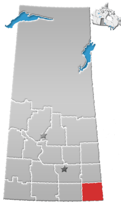 | ||||
|---|---|---|---|---|---|
| Towns | |||||
| Villages | |||||
| Rural municipalities | |||||
| First Nations |
| ||||
| Indian reserves | |||||
| Unincorporated communities |
| ||||