Lake Lenore, Saskatchewan
Lake Lenore (2016 population: 284) is a village in the Canadian province of Saskatchewan within the Rural Municipality of Lake Lenore No. 399 and Census Division No. 15. The village is located 144.6 km northeast of the City of Saskatoon. Outside of the village is a lake that shares its name, Lake Lenore, renowned for its fishing activity as well the Rural Municipality of Lake Lenore No. 399 to the north. Lake Lenore possesses a fully operational school, Co-op Grocery and Agro Service Station and also contains a Credit Union and Public Library.
Lake Lenore | |
|---|---|
| Village of Lake Lenore | |
 Lake Lenore Location of Lake Lenore in Saskatchewan  Lake Lenore Lake Lenore (Canada) | |
| Coordinates: 52.393°N 104.941°W | |
| Country | |
| Province | |
| Region | Central |
| Census division | 15 |
| Rural Municipality | St. Peter No. 369 |
| Post office Founded | 1906 |
| Government | |
| • Type | Municipal |
| • Governing body | Lake Lenore Village Council |
| • Mayor | Travis Thompson |
| • Administrator | Barb Politeski |
| Area | |
| • Total | 0.97 km2 (0.37 sq mi) |
| Population (2016) | |
| • Total | 284 |
| • Density | 292.9/km2 (759/sq mi) |
| Time zone | UTC-6 (CST) |
| Postal code | S0K 2J0 |
| Area code(s) | 306 |
| Highways | |
| Railways | Canadian National Railway |
| Website | Village of Lake Lenore |
| [1][2][3][4] | |
History
Lake Lenore incorporated as a village on April 28, 1921.[5]
Demographics
In the 2016 Census of Population conducted by Statistics Canada, the Village of Lake Lenore recorded a population of 284 living in 117 of its 128 total private dwellings, a -4.6% change from its 2011 population of 297. With a land area of 0.97 km2 (0.37 sq mi), it had a population density of 292.8/km2 (758.3/sq mi) in 2016.[8]
In the 2011 Census of Population, the Village of Lake Lenore recorded a population of 297, a -2.9% change from its 2006 population of 306. With a land area of 0.97 km2 (0.37 sq mi), it had a population density of 306.2/km2 (793.0/sq mi) in 2011.[9]
See also
- List of communities in Saskatchewan
- Villages of Saskatchewan
References
- National Archives, Archivia Net. "Post Offices and Postmasters". Archived from the original on 2006-10-06. Retrieved 2014-10-13.
- Government of Saskatchewan, MRD Home. "Municipal Directory System". Archived from the original on 2016-01-15. Retrieved 2014-10-13.
- Canadian Textiles Institute. (2005), CTI Determine your provincial constituency, archived from the original on 2007-09-11
- Commissioner of Canada Elections, Chief Electoral Officer of Canada (2005), Elections Canada On-line, archived from the original on 2007-04-21
- "Urban Municipality Incorporations". Saskatchewan Ministry of Government Relations. Archived from the original on October 15, 2014. Retrieved June 1, 2020.
- "Saskatchewan Census Population" (PDF). Saskatchewan Bureau of Statistics. Archived from the original (PDF) on September 24, 2015. Retrieved May 31, 2020.
- "Saskatchewan Census Population". Saskatchewan Bureau of Statistics. Retrieved May 31, 2020.
- "Population and dwelling counts, for Canada, provinces and territories, and census subdivisions (municipalities), 2016 and 2011 censuses – 100% data (Saskatchewan)". Statistics Canada. February 8, 2017. Retrieved May 30, 2020.
- "Population and dwelling counts, for Canada, provinces and territories, and census subdivisions (municipalities), 2011 and 2006 censuses (Saskatchewan)". Statistics Canada. June 3, 2019. Retrieved May 30, 2020.
External links
- Municipal Directory Saskatchewan - Village of Lake Lenore
- Saskatchewan City & Town Maps
- Saskatchewan Gen Web - One Room School Project
- Post Offices and Postmasters - ArchiviaNet - Library and Archives Canada
- Saskatchewan Gen Web Region
- Online Historical Map Digitization Project
- GeoNames Query
- 2006 Community Profiles
Places adjacent to Lake Lenore, Saskatchewan | |
|---|---|
| Cities | 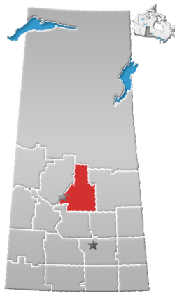 | ||
|---|---|---|---|
| Towns | |||
| Villages |
| ||
| Resort villages | |||
| Rural municipalities |
| ||
| First Nations | |||
| Indian reserves | |||
| Unincorporated communities |
| ||