Bradwell, Saskatchewan
Bradwell (2016 population: 166) is a village in the Canadian province of Saskatchewan within the Rural Municipality of Blucher No. 343 and Census Division No. 11. The village is located about 36 km southeast of the City of Saskatoon on Highway 763. In 1936, during excavations of gravel for a highway, the partial skeleton of a neolithic human male were discovered and named "Bradwell Man". A stone scraper and some eagle talons were found nearby.[5]
Bradwell | |
|---|---|
| Village of Bradwell | |
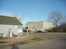
 Former Saskatchewan Wheat Pool Grain elevator in Bradwell | |
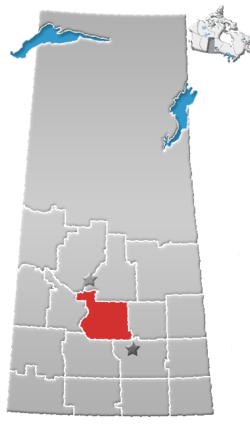
 Location of Bradwell in Saskatchewan  Bradwell, Saskatchewan (Canada) | |
| Coordinates: 51.9475°N 106.2315°W | |
| Country | Canada |
| Province | Saskatchewan |
| Region | Central |
| Census division | 15 |
| Rural Municipality | Blucher |
| Post office founded | 1906 (as Sunny Plain) |
| Post office closed | 1986 |
| Incorporated (Village) | 1912 |
| Government | |
| • Type | Municipal |
| • Governing body | Bradwell Village Council |
| • Mayor | Timothy Yanke |
| • Administrator | Robert Thurmeier |
| Area | |
| • Total | 0.42 km2 (0.16 sq mi) |
| Population (2016) | |
| • Total | 166 |
| • Density | 399.7/km2 (1,035/sq mi) |
| Time zone | CST |
| Postal code | S0K 0P0 |
| Area code(s) | 306 |
| Highways | Hwy 763 |
| Railways | Canadian National Railway |
| [1][2][3][4] | |
History
Bradwell incorporated as a village on December 26, 1912.[6]
Demographics
In the 2016 Census of Population conducted by Statistics Canada, the Village of Bradwell recorded a population of 166 living in 62 of its 65 total private dwellings, a -38.6% change from its 2011 population of 230. With a land area of 0.42 km2 (0.16 sq mi), it had a population density of 395.2/km2 (1,023.7/sq mi) in 2016.[9]
In the 2011 Census of Population, the Village of Bradwell recorded a population of 230, a 26.4% change from its 2006 population of 182. With a land area of 0.42 km2 (0.16 sq mi), it had a population density of 547.6/km2 (1,418.3/sq mi) in 2011.[10]
See also
- List of communities in Saskatchewan
- Villages of Saskatchewan
References
- National Archives, Archivia Net, Post Offices and Postmasters, archived from the original on 2006-10-06
- Government of Saskatchewan, MRD Home, Municipal Directory System, archived from the original on 2008-11-21, retrieved – Scholar search Check date values in:
|accessdate=(help) - Canadian Textiles Institute. (2005), CTI Determine your provincial constituency, archived from the original on 2007-09-11
- Commissioner of Canada Elections, Chief Electoral Officer of Canada (2005), Elections Canada On-line, archived from the original on 2007-04-21
- Edmunds, F. H.; Jackson, J. L.; Spinks, J. W. T.; Vigfusson, V. A. (January 1938), "Some skeletal remains in Saskatchewan", American Antiquity, Society for American Archaeology, 3 (3): 244–246, doi:10.2307/275261, JSTOR 275261
- "Urban Municipality Incorporations". Saskatchewan Ministry of Government Relations. Archived from the original on October 15, 2014. Retrieved June 1, 2020.
- "Saskatchewan Census Population" (PDF). Saskatchewan Bureau of Statistics. Archived from the original (PDF) on September 24, 2015. Retrieved May 31, 2020.
- "Saskatchewan Census Population". Saskatchewan Bureau of Statistics. Retrieved May 31, 2020.
- "Population and dwelling counts, for Canada, provinces and territories, and census subdivisions (municipalities), 2016 and 2011 censuses – 100% data (Saskatchewan)". Statistics Canada. February 8, 2017. Retrieved May 30, 2020.
- "Population and dwelling counts, for Canada, provinces and territories, and census subdivisions (municipalities), 2011 and 2006 censuses (Saskatchewan)". Statistics Canada. June 3, 2019. Retrieved May 30, 2020.