Lloydminster
Lloydminster is a Canadian city which has the unusual geographic distinction of straddling the provincial border between Alberta and Saskatchewan.[12] The city is incorporated by both provinces as a single city with a single municipal administration.
Lloydminster | |
|---|---|
City | |
| City of Lloydminster | |
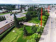 An aerial view of Lloydminster City Hall looking north along the Alberta / Saskatchewan border | |
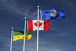
 Flag  Seal | |
| Nickname(s): | |
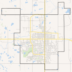 Boundaries of Lloydminster | |
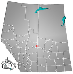 Location in Alberta and Saskatchewan | |
| Coordinates: 53°16.7′N 110°0.3′W | |
| Country | Canada |
| Provinces | Alberta (AB) Saskatchewan (SK) |
| Regions | Central Alberta, West Central Saskatchewan |
| Census divisions | 10 (AB), 17 (SK) |
| Adjacent municipal district | County of Vermilion River |
| Adjacent rural municipalities | RM of Wilton No. 472 and RM of Britannia No. 502 |
| Incorporated[3] | |
| • Village (SK) | November 25, 1903 |
| • Village (AB) | July 6, 1906 |
| • Town (SK) | April 1, 1907 |
| • Amalgamation | May 22, 1930 |
| • City | January 1, 1958 |
| Government | |
| • Mayor | Gerald Aalbers |
| • Governing body | Lloydminster City Council
|
| • City Manager | Dion Pollard |
| • MP | Shannon Stubbs (C) Rosemarie Falk (C) |
| • MLA | Garth Rowswell (AB, UCP) Colleen Young (SK, SP) |
| Area | |
| • City | 42.32 km2 (16.34 sq mi) |
| Elevation | 645 m (2,116 ft) |
| Population | |
| • City | 31,410 – 19,645 (AB) – 11,765 (SK) |
| • Density | 742.2/km2 (1,922/sq mi) |
| • Urban | 31,400 |
| • Municipal census (2015) | 31,377[11] – 19,740 (AB) – 11,637 (SK) |
| Time zone | UTC−07:00 (MST) |
| • Summer (DST) | UTC−06:00 (MDT) |
| Forward sortation areas | T9V (AB), S9V (SK) |
| Area code(s) | 780, 587, 825 (AB) 306, 639 (SK) |
| Website | www |
History
Intended to be an exclusively British utopian settlement centred on the idea of sobriety, the town was founded in 1903 by the Barr Colonists, who came directly from the United Kingdom.[13] At a time when the area was still part of the North-West Territories, the town was located astride the Fourth Meridian of the Dominion Land Survey. This meridian was intended to coincide with 110° west longitude, although the imperfect surveying methods of the time led to the surveyed meridian being placed a few hundred metres west of this longitude.
The town was named for George Lloyd, an Anglican priest who in 1922 would become Bishop of Saskatchewan. Lloyd was a strong opponent of non-British immigration to Canada. During a nearly disastrous immigration journey, which was badly planned and conducted,[14] he distinguished himself with the colonists and replaced the Barr Colony's leader and namesake Isaac Montgomery Barr during the colonists' journey to the eventual townsite.
The town developed rapidly: by 1904 there was a telegraph office as well as a log church; in 1905 the Lloydminster Daily Times started publication and the first train arrived on July 28.[15]
While provincehood of some sort for the prairie territories was seen as inevitable by 1903, it had been widely expected that only one province would eventually be created instead of two. The colonists were not aware of the federal government's deep-rooted opposition to the creation of a single province and thus had no way of knowing that the Fourth Meridian was under consideration as a future provincial boundary. Had they known, it is very unlikely they would have sited the new settlement on the future border.
When the provinces of Alberta and Saskatchewan were created in 1905, the Fourth Meridian was selected as the border, bisecting the town. Caught by surprise, Lloydminster residents petitioned for the new border to be revised so as to encompass the entire town within Saskatchewan, without success.
For the next quarter century, Lloydminster remained two separate towns with two separate municipal administrations. Finally, in 1930 the provincial governments agreed to amalgamate the towns into a single town under shared jurisdiction. The provinces, again jointly, reincorporated Lloydminster as a city in 1958.
Commemorating Lloydminster's distinctive bi-provincial status, a monument consisting of four 100-foot survey markers was erected in 1994 near the city's downtown core.[16]
Although the majority of Lloydminster's population once lived in Saskatchewan, that ratio has long since been reversed; in the 2011 Canadian Census, nearly two-thirds of the city's population lived in Alberta. In 2000, the city hall and municipal offices were re-located from Saskatchewan to Alberta.
Lloydminster was not exempted from anti-smoking legislation passed by the Legislative Assembly of Saskatchewan. Citizens responded by initiating a referendum against the wishes of the mayor, as permitted in the charter, which resulted in the enactment of a citywide anti-smoking bylaw. The matter was made a moot point when Alberta enacted its own anti-smoking legislation, which was the solution that the mayor and council preferred.
Since Lloydminster's founders were attempting to create a utopian, temperance society, alcohol was not available in Lloydminster for the first few years after its founding.
Geography
The provincial border runs north to south, falling directly on 50th Avenue (Meridian Avenue) in the centre of Lloydminster. Addresses east of 50th Avenue are considered to be in Lloydminster, Saskatchewan and addresses west of 50th Avenue are considered to be in Lloydminster, Alberta. The city is bordered by the County of Vermilion River, Alberta, on the west, the Rural Municipality (R.M.) of Britannia No. 502, Saskatchewan, on the northeast and the R.M. of Wilton No. 472, Saskatchewan, on the southeast.
Lloydminster's distinctive situation is reflected in other legal matters, including its time zone. Most of Saskatchewan does not observe daylight saving time, instead staying on Central Standard Time year-round. However, Alberta mandates daylight saving time. Lloydminster's charter allows the city to follow Alberta's use of daylight saving time on both sides of the provincial border in order to keep all clocks within the city in sync. This has the effect of placing Lloydminster and the surrounding area in the Mountain Time Zone along with Alberta. During the summer, the entire city is on UTC−06:00—Mountain Daylight Time in Lloydminster and Central Standard Time in the rest of Saskatchewan. During the winter, Lloydminster is on Mountain Standard Time with the rest of Alberta, which is UTC−07:00.
The provincial line divides the city in two aspects related to communications. Telephones on the Saskatchewan side are assigned to area codes 306 and 639, the two area codes assigned to that province, while land lines on the Alberta side have numbers in the 780 and 587 area codes, the two area codes assigned to northern Alberta. Similarly, Saskatchewan addresses have a postal code with a forward sortation area designation (first three characters) of "S9V", and addresses in Alberta have postal codes beginning with "T9V". All postal codes in Canada beginning with the letter "S" are assigned to Saskatchewan, and those beginning with "T" belong to Alberta.
Climate
Lloydminster experiences a humid continental climate (Köppen climate classification Dfb), which approaches a subarctic climate (Köppen Dfc) due to May and September being only marginally above 10 °C (50 °F). Winters are long, cold and dry, while summers are short, warm and moderately wet. Year-round precipitation is fairly low, with an average of 408 mm (16.06 in), whilst the dry winters restrict snowfall to 98 cm (38.6 in).
The highest temperature ever recorded in Lloydminster was 38.1 °C (100.6 °F) on 12 July 2002.[17] The coldest temperature ever recorded was −50.0 °C (−58.0 °F) on 13 January 1911.[18]
| Climate data for Lloydminster Airport, 1981–2010 normals, extremes 1904–present[lower-alpha 1] | |||||||||||||
|---|---|---|---|---|---|---|---|---|---|---|---|---|---|
| Month | Jan | Feb | Mar | Apr | May | Jun | Jul | Aug | Sep | Oct | Nov | Dec | Year |
| Record high humidex | 10.4 | 8.2 | 18.6 | 27.1 | 34.7 | 39.0 | 42.5 | 38.4 | 32.8 | 26.5 | 16.3 | 9.5 | 42.5 |
| Record high °C (°F) | 10.6 (51.1) |
12.8 (55.0) |
18.6 (65.5) |
32.8 (91.0) |
36.7 (98.1) |
37.8 (100.0) |
38.1 (100.6) |
37.4 (99.3) |
35.0 (95.0) |
28.9 (84.0) |
19.5 (67.1) |
10.0 (50.0) |
38.1 (100.6) |
| Average high °C (°F) | −9.6 (14.7) |
−6.9 (19.6) |
−1.0 (30.2) |
9.9 (49.8) |
16.7 (62.1) |
20.7 (69.3) |
23.1 (73.6) |
22.4 (72.3) |
16.5 (61.7) |
9.1 (48.4) |
−2.6 (27.3) |
−7.9 (17.8) |
7.5 (45.5) |
| Daily mean °C (°F) | −14.3 (6.3) |
−11.7 (10.9) |
−5.6 (21.9) |
4.0 (39.2) |
10.1 (50.2) |
14.6 (58.3) |
17.0 (62.6) |
15.9 (60.6) |
10.3 (50.5) |
3.4 (38.1) |
−6.8 (19.8) |
−12.5 (9.5) |
2.0 (35.6) |
| Average low °C (°F) | −18.9 (−2.0) |
−16.6 (2.1) |
−10.3 (13.5) |
−2.0 (28.4) |
3.5 (38.3) |
8.5 (47.3) |
10.8 (51.4) |
9.3 (48.7) |
4.0 (39.2) |
−2.3 (27.9) |
−11.0 (12.2) |
−17.0 (1.4) |
−3.5 (25.7) |
| Record low °C (°F) | −50.0 (−58.0) |
−48.3 (−54.9) |
−36.7 (−34.1) |
−28.9 (−20.0) |
−16.7 (1.9) |
−6.7 (19.9) |
−3.3 (26.1) |
−5.0 (23.0) |
−13.9 (7.0) |
−24.0 (−11.2) |
−34.4 (−29.9) |
−46.7 (−52.1) |
−50.0 (−58.0) |
| Record low wind chill | −54.6 | −54.5 | −49.8 | −30.3 | −15.7 | −4.9 | 0.0 | −6.1 | −14.7 | −35.8 | −50.9 | −54.0 | −54.6 |
| Average precipitation mm (inches) | 15.8 (0.62) |
9.8 (0.39) |
14.4 (0.57) |
26.3 (1.04) |
44.6 (1.76) |
70.6 (2.78) |
75.3 (2.96) |
59.9 (2.36) |
42.3 (1.67) |
17.8 (0.70) |
17.6 (0.69) |
14.4 (0.57) |
408.8 (16.09) |
| Average rainfall mm (inches) | 0.4 (0.02) |
0.2 (0.01) |
1.6 (0.06) |
13.2 (0.52) |
40.8 (1.61) |
70.6 (2.78) |
75.3 (2.96) |
59.7 (2.35) |
40.5 (1.59) |
11.6 (0.46) |
2.3 (0.09) |
0.5 (0.02) |
316.7 (12.47) |
| Average snowfall cm (inches) | 17.0 (6.7) |
9.8 (3.9) |
13.4 (5.3) |
13.4 (5.3) |
4.2 (1.7) |
0.0 (0.0) |
0.0 (0.0) |
0.1 (0.0) |
1.8 (0.7) |
6.4 (2.5) |
16.7 (6.6) |
15.3 (6.0) |
98.1 (38.7) |
| Average precipitation days (≥ 0.2 mm) | 9.7 | 7.3 | 8.0 | 7.6 | 10.5 | 13.2 | 12.2 | 10.5 | 9.0 | 7.1 | 9.4 | 9.8 | 114.2 |
| Average rainy days (≥ 0.2 mm) | 0.7 | 0.1 | 1.1 | 4.8 | 9.9 | 13.2 | 12.2 | 10.5 | 8.7 | 4.9 | 1.3 | 0.6 | 68.0 |
| Average snowy days (≥ 0.2 cm) | 9.4 | 7.4 | 7.4 | 3.9 | 1.5 | 0.0 | 0.0 | 0.0 | 0.7 | 3.0 | 8.7 | 9.7 | 51.7 |
| Average relative humidity (%) | 74.2 | 73.0 | 67.4 | 48.2 | 42.4 | 49.6 | 53.9 | 50.2 | 50.0 | 54.0 | 73.3 | 75.9 | 59.3 |
| Source: Environment Canada[17][19][20][21][22] | |||||||||||||
Demographics
| Federal census population history | ||
|---|---|---|
| Year | Pop. | ±% |
| 1906 | 519 | — |
| 1911 | 663 | +27.7% |
| 1916 | 788 | +18.9% |
| 1921 | 755 | −4.2% |
| 1926 | 1,247 | +65.2% |
| 1931 | 1,516 | +21.6% |
| 1936 | 1,420 | −6.3% |
| 1941 | 1,624 | +14.4% |
| 1946 | 1,833 | +12.9% |
| 1951 | 3,938 | +114.8% |
| 1956 | 5,077 | +28.9% |
| 1961 | 5,667 | +11.6% |
| 1966 | 7,071 | +24.8% |
| 1971 | 8,691 | +22.9% |
| 1976 | 10,311 | +18.6% |
| 1981 | 15,031 | +45.8% |
| 1986 | 17,356 | +15.5% |
| 1991 | 17,283 | −0.4% |
| 1996 | 18,953 | +9.7% |
| 2001 | 20,988 | +10.7% |
| 2006 | 24,028 | +14.5% |
| 2011 | 27,804 | +15.7% |
| 2016 | 31,410 | +13.0% |
| Source: Statistics Canada [23][24][25][26][27][28][29][30][31][32][33] [34][35][36][37][38][39][40][41][42][43][5][8] | ||
In the 2016 Census of Population conducted by Statistics Canada, the Alberta portion of the City of Lloydminster recorded a population of 19,645 living in 7,444 of its 8,444 total private dwellings, a change of 8.9% from its 2011 population of 18,032. With a land area of 24.04 km2 (9.28 sq mi), it had a population density of 817.2/km2 (2,116.5/sq mi) in 2016.[8] Meanwhile, the Saskatchewan portion of Lloydminster recorded a population of 11,765 living in 4,392 of its 4,909 total private dwellings, a change of 20.4% from its 2011 population of 9,772. With a land area of 18.28 km2 (7.06 sq mi), it had a population density of 643.6/km2 (1,666.9/sq mi) in 2016.[9] Overall, the entire City of Lloydminster recorded a population of 31,410 living in 11,836 of its 13,353 total private dwellings in the 2016 Census of Population, a change of 13% from its 2011 population of 27,804. With a land area of 42.32 km2 (16.34 sq mi), it had a population density of 742.2/km2 (1,922.3/sq mi) in 2016.[8][9]
The City of Lloydminster's 2015 municipal census counted a population of 31,377,[44] a change of -0.3% from its 2013 municipal census population of 31,483.[11] Of the 31,377 residents, 19,740 (63%) lived on the Alberta side and 11,637 (37%) lived on the Saskatchewan side.[11]
In the 2011 Census, the City of Lloydminster had a population of 27,804 living in 10,613 of its 11,453 total dwellings, a change of 15.7% from its 2006 population of 24,028. With a land area of 41.53 km2 (16.03 sq mi), it had a population density of 669.5/km2 (1,734.0/sq mi) in 2011.[5][6] Of this total, 18,032 people (65%) lived on the Alberta side and 9,772 (35%) lived on the Saskatchewan side.
There are substantial demographic differences between the populations on each side of the border, with the population on the Saskatchewan side being substantially younger; the median age on the Saskatchewan side is 26.6,[45] nearly seven years less than the median age of 33.2 on the Alberta side. Even when combining the median ages for both sides of the city, Lloydminster has the youngest median age in all of Canada.[46][47] Also, the specific age group of 20–24 is much more concentrated on the Saskatchewan side. The two sides of the city have virtually identical numbers of people in that age group (1,220 in Saskatchewan,[45] 1,230 in Alberta[46]) even though the total population on the Alberta side is nearly twice that of the Saskatchewan side. This situation has been attributed in part to differential car insurance rates for drivers; because Saskatchewan has a public auto insurance system while Alberta relies on conventional private insurance, young drivers with the highest insurance rates can save thousands of dollars by living in Saskatchewan rather than Alberta.[48]
The census agglomeration of Lloydminster includes both parts of the city, as well as the rural municipality of Wilton No. 472, the town of Lashburn, and the village of Marshall, Saskatchewan.
About 94% of residents identified English as their first language. More than 1.4% of the population identified French as their first language, while 0.8% identified German, 0.7% identified Ukrainian, and 0.5% identified Cree as their first language learned. The next most common languages were Chinese and Spanish at about 0.3% each.[49]
More than 78% of residents identified as Christian at the time of the 2001 census, while over 18% indicated that they had no religious affiliation. For specific denominations Statistics Canada found that 31% of residents identified as Roman Catholic, and 44% Protestants of which, 18% identified with the United Church of Canada, more than 7% identified as Anglican, about 5% identified as Lutheran, almost 3% identified as Pentecostal, about 2% identified as Baptists, and just over 1% of the population identified as Eastern Orthodox.[50]
More than 8% of residents identified themselves as aboriginal at the time of the 2006 census.[51]
| Visible minorities and Aboriginal population | |||
|---|---|---|---|
| Canada 2016 Census[52] | Population | % of Total Population | |
| Visible minority group | South Asian | 1,125 | 3.6% |
| Chinese | 145 | 0.5% | |
| Black | 510 | 1.7% | |
| Filipino | 2,440 | 7.9% | |
| Latin American | 165 | 0.5% | |
| Southeast Asian | 190 | 0.6% | |
| Arab | 175 | 0.6% | |
| West Asian | 20 | 0.1% | |
| Korean | 75 | 0.2% | |
| Japanese | 15 | 0% | |
| Mixed visible minority | 100 | 0.3% | |
| Visible minority, n.i.e. | 30 | 0.1% | |
| Total visible minority population | 5,000 | 16.2% | |
| Aboriginal group | First Nations | 1,285 | 4.2% |
| Métis | 1,965 | 6.4% | |
| Inuit | 10 | 0% | |
| Multiple Aboriginal responses | 35 | 0.1% | |
| Aboriginal, n.i.e. | 25 | 0.1% | |
| Total Aboriginal population | 3,315 | 10.7% | |
| White | 22,570 | 73.1% | |
| Total population | 30,885 | 100% | |
Economy
The local economy is driven primarily by the petroleum industry. Agriculture remains an important economic activity. The Husky Lloydminster Refinery is also located in the community. An issue in business is the sales tax. The only sales tax applicable in Alberta is the federal GST. Saskatchewan has in addition to GST a PST, or provincial sales tax. To ensure that business will not float away from the Saskatchewan side in favour of lower prices in Alberta, PST does not apply in the Saskatchewan side of the city[53] with the exception of hotels, vehicle registration and utility services.
Government
Lloydminster is governed by a seven-member city council, consisting of a mayor and six city councillors. The city follows the Saskatchewan schedule when voting in municipal elections.[54]
Residents on the Alberta side are in the electoral district of Lakeland for elections to the federal House of Commons, and Vermilion-Lloydminster-Wainwright for elections to the Legislative Assembly of Alberta. Residents in Saskatchewan are in Battlefords—Lloydminster federally, and Lloydminster for the Legislative Assembly of Saskatchewan.
Taxation
Lloydminster's bi-provincial status has resulted in special provisions regarding provincial taxation within the city limits. The Saskatchewan side of the city is exempt from that province's sales tax, preventing businesses located there from being placed at a disadvantage relative to businesses in Alberta, which has no provincial sales tax.[53] There is no exemption for provincial income tax, which is based solely on the taxpayer's province of residence. Other differences surrounding interprovincial costs are reflected within the treatment of automobile insurance, and housing taxes. For example, a driver under age 25 who lives on the Alberta side will pay approximately 2-3 times the average amount required of a Saskatchewan driver of the same age.[55]
Infrastructure
Health care
The Lloydminster Hospital, located on the Saskatchewan side of the city, serves residents of both sides, through an agreement between the Alberta and Saskatchewan governments. This is of note because Alberta's health care system is significantly more privatized than that in Saskatchewan.
Transportation
The city is served by Lloydminster Airport. The Yellowhead Highway, (Alberta Highway 16 and Saskatchewan Highway 16) passes through the city from west to east, and Highway 17 (which is considered part of both Alberta's and Saskatchewan's highway system and is maintained by both provinces) travels along the provincial border from south to north.
Education
Elementary and secondary schools on both sides of the border all use Saskatchewan's curriculum.[56] Lloydminster provides post-secondary education through Lakeland College, offering one and two year certificate and diploma programs.[57]
Media
- Newspapers
- Lloydminster Meridian Booster, serves Lloydminster and area, circulating to 15,000 homes. Published Monday, Wednesday and Friday each week.
- Lloydminster Source is a free weekly newspaper, distributed each Tuesday and Thursday.
- Radio
| Frequency | Call sign | Branding | Format | Owner | Notes |
|---|---|---|---|---|---|
| AM 540 | CBK | CBC Radio One | Talk radio, public radio | Canadian Broadcasting Corporation | |
| FM 95.9 | CKSA-FM | Real Country 95.9 | Country music | Stingray Group | |
| FM 97.5 | CKUA-FM-15 | CKUA Radio | Variety, public radio | CKUA Radio Foundation | Rebroadcaster of CKUA-FM (Edmonton) |
| FM 98.9 | CILR-FM | – | Tourist information | Stingray Group | |
| FM 106.1 | CKLM-FM | 106.1 The Goat | Active rock | Vista Radio |
- Television
Lloydminster is served by two broadcast television stations, operated as part of a twinstick operation owned by Newcap Radio:
| OTA virtual channel (PSIP) | OTA channel | Call sign | Network | Notes |
|---|---|---|---|---|
| 2.1 | 2 (VHF) | CKSA-DT | Global | Privately owned affiliate |
| 4.1 | 4 (VHF) | CITL-DT | CTV | Privately owned affiliate |
Notable people
- Ron Adam - Canadian Football League (CFL) defensive back
- Colby Armstrong - National Hockey League (NHL) forward
- Calvin Ayre - Founder of the online gambling company Bodog
- Garnet "Ace" Bailey - NHL forward, died on United Airlines Flight 175
- Leon Benoit - Canadian politician
- Samuel Delbert Clark - sociologist
- Joan Crockatt - Canadian politician, journalist
- Cory Cross - NHL defenceman
- David Dziurzynski - NHL forward
- Rosemarie Falk - Canadian politician
- Scott Hartnell - NHL forward
- Braden Holtby - NHL goaltender
- Skip Krake - NHL forward who now lives in Lloydminster[58]
- Clarke MacArthur - NHL forward
- Lucella MacLean - AAGPBL utility
- James Hanna McCormick - Northern Irish politician
- Keith Morrison - journalist, newscaster[59]
- Wade Redden - NHL defenceman
- Richard Starke - Canadian politician
- James Till - biophysicist who helped demonstrate the existence of stem cells[60]
- Lance Ward - NHL defenceman
- Tyler Weiman - NHL goaltender
- Colleen Young - Saskatchewan politician
See also
| Wikimedia Commons has media related to Lloydminster. |
- Flin Flon, a town split between Manitoba and Saskatchewan
- List of communities in Alberta
- List of communities in Saskatchewan
- List of cities in Alberta
- Lloydminster Public Library
References
- Carl Carter (2011-02-03). "Bobcats leaving the Border City?". Lloydminster Meridian Booster. Sun Media Corporation. Archived from the original on 2013-01-28. Retrieved 2012-06-05.
- "Mayor's Office". City of Lloydminster. Archived from the original on 2012-09-27. Retrieved 2012-06-05.
- "Location and History Profile: City of Lloydminster" (PDF). Alberta Municipal Affairs. June 17, 2016. p. 85. Retrieved June 18, 2016.
- "Municipal Officials Search". Alberta Municipal Affairs. September 22, 2017. Retrieved September 25, 2017.
- "Population and dwelling counts, for Canada, provinces and territories, and census subdivisions (municipalities), 2011 and 2006 censuses (Alberta)". Statistics Canada. 2012-02-08. Retrieved 2012-02-08.
- "Population and dwelling counts, for Canada, provinces and territories, and census subdivisions (municipalities), 2011 and 2006 censuses (Saskatchewan)". Statistics Canada. 2012-02-08. Retrieved 2012-02-08.
- "Alberta Private Sewage Systems 2009 Standard of Practice Handbook: Appendix A.3 Alberta Design Data (A.3.A. Alberta Climate Design Data by Town)" (PDF) (PDF). Safety Codes Council. January 2012. pp. 212–215 (PDF pages 226–229). Retrieved October 8, 2013.
- "Population and dwelling counts, for Canada, provinces and territories, and census subdivisions (municipalities), 2016 and 2011 censuses – 100% data (Alberta)". Statistics Canada. February 8, 2017. Retrieved February 8, 2017.
- "Population and dwelling counts, for Canada, provinces and territories, and census subdivisions (municipalities), 2016 and 2011 censuses – 100% data (Saskatchewan)". Statistics Canada. February 8, 2017. Retrieved February 8, 2017.
- "Census Profile, 2016 Census: Lloydminster [Population centre], Alberta/Saskatchewan and Alberta [Province]". Statistics Canada. April 24, 2018. Retrieved December 23, 2018.
- "2013 Municipal Census: City of Lloydminster population increased". City of Lloydminster. September 9, 2013. Archived from the original on April 9, 2015. Retrieved September 9, 2013.
- Lloydminster at The Canadian Encyclopedia.
- "Saskatchewan's Top News Stories: Beginnings And Landmarks". Library2.usask.ca. 1903-04-10. Retrieved 2017-04-30.
- Shara Buchan. History of Lloydminster
- Lloydminster History of Recreation and Cultural Activities Committee (1979). 75 years of sport and culture in Lloydminster : 1903-1978. p. i.
- "City of Lloydminster". Bigthings.ca. Retrieved 2017-04-30.
- "Lloydminster A". Environment Canada. Retrieved 1 May 2016.
- "Daily Data Report for January 1911". Environment Canada. Retrieved 10 July 2016.
- "Lloydminster SK". Environment Canada. 2011-10-31. Retrieved 1 May 2016.
- "Lloydminster AB". Environment Canada. 2011-10-31. Retrieved 1 May 2016.
- "Lloydminster North". Environment Canada. 2011-10-31. Retrieved 1 May 2016.
- "Lloydminster 12E". Environment Canada. 2011-10-31. Retrieved 1 May 2016.
- "Table IX: Population of cities, towns and incorporated villages in 1906 and 1901 as classed in 1906". Census of the Northwest Provinces, 1906. Sessional Paper No. 17a. Ottawa: Government of Canada. 1907. p. 100.
- "Table I: Area and Population of Canada by Provinces, Districts and Subdistricts in 1911 and Population in 1901". Census of Canada, 1911. Volume I. Ottawa: Government of Canada. 1912. pp. 2–39.
- "Table I: Population of Manitoba, Saskatchewan, and Alberta by Districts, Townships, Cities, Towns, and Incorporated Villages in 1916, 1911, 1906, and 1901". Census of Prairie Provinces, 1916. Population and Agriculture. Ottawa: Government of Canada. 1918. pp. 77–140.
- "Table 8: Population by districts and sub-districts according to the Redistribution Act of 1914 and the amending act of 1915, compared for the census years 1921, 1911 and 1901". Census of Canada, 1921. Ottawa: Government of Canada. 1922. pp. 169–215.
- "Table 7: Population of cities, towns and villages for the province of Alberta in census years 1901-26, as classed in 1926". Census of Prairie Provinces, 1926. Census of Alberta, 1926. Ottawa: Government of Canada. 1927. pp. 565–567.
- "Table 12: Population of Canada by provinces, counties or census divisions and subdivisions, 1871-1931". Census of Canada, 1931. Ottawa: Government of Canada. 1932. pp. 98–102.
- "Table 4: Population in incorporated cities, towns and villages, 1901-1936". Census of the Prairie Provinces, 1936. Volume I: Population and Agriculture. Ottawa: Dominion Bureau of Statistics. 1938. pp. 833–836.
- "Table 10: Population by census subdivisions, 1871–1941". Eighth Census of Canada, 1941. Volume II: Population by Local Subdivisions. Ottawa: Dominion Bureau of Statistics. 1944. pp. 134–141.
- "Table 6: Population by census subdivisions, 1926-1946". Census of the Prairie Provinces, 1946. Volume I: Population. Ottawa: Dominion Bureau of Statistics. 1949. pp. 401–414.
- "Table 6: Population by census subdivisions, 1871–1951". Ninth Census of Canada, 1951. Volume I: Population, General Characteristics. Ottawa: Dominion Bureau of Statistics. 1953. p. 6.73–6.83.
- "Table 6: Population by sex, for census subdivisions, 1956 and 1951". Census of Canada, 1956. Population, Counties and Subdivisions. Ottawa: Dominion Bureau of Statistics. 1957. p. 6.50–6.53.
- "Table 6: Population by census subdivisions, 1901–1961". 1961 Census of Canada. Series 1.1: Historical, 1901–1961. Volume I: Population. Ottawa: Dominion Bureau of Statistics. 1963. p. 6.77–6.83.
- "Population by specified age groups and sex, for census subdivisions, 1966". Census of Canada, 1966. Population, Specified Age Groups and Sex for Counties and Census Subdivisions, 1966. Ottawa: Dominion Bureau of Statistics. 1968. p. 6.50–6.53.
- "Table 2: Population of Census Subdivisions, 1921–1971". 1971 Census of Canada. Volume I: Population, Census Subdivisions (Historical). Ottawa: Statistics Canada. 1973. p. 2.102–2.111.
- "Table 3: Population for census divisions and subdivisions, 1971 and 1976". 1976 Census of Canada. Census Divisions and Subdivisions, Western Provinces and the Territories. Volume I: Population, Geographic Distributions. Ottawa: Statistics Canada. 1977. p. 3.40–3.43.
- "Table 4: Population and Total Occupied Dwellings, for Census Divisions and Subdivisions, 1976 and 1981". 1981 Census of Canada. Volume II: Provincial series, Population, Geographic distributions (Alberta). Ottawa: Statistics Canada. 1982. p. 4.1–4.10. ISBN 0-660-51095-2.
- "Table 2: Census Divisions and Subdivisions – Population and Occupied Private Dwellings, 1981 and 1986". Census Canada 1986. Population and Dwelling Counts – Provinces and Territories (Alberta). Ottawa: Statistics Canada. 1987. p. 2.1–2.10. ISBN 0-660-53463-0.
- "Table 2: Population and Dwelling Counts, for Census Divisions and Census Subdivisions, 1986 and 1991 – 100% Data". 91 Census. Population and Dwelling Counts – Census Divisions and Census Subdivisions. Ottawa: Statistics Canada. 1992. pp. 100–108. ISBN 0-660-57115-3.
- "Table 10: Population and Dwelling Counts, for Census Divisions, Census Subdivisions (Municipalities) and Designated Places, 1991 and 1996 Censuses – 100% Data". 96 Census. A National Overview – Population and Dwelling Counts. Ottawa: Statistics Canada. 1997. pp. 136–146. ISBN 0-660-59283-5.
- "Population and Dwelling Counts, for Canada, Provinces and Territories, and Census Divisions, 2001 and 1996 Censuses - 100% Data (Alberta)". Statistics Canada. Retrieved 2012-04-01.
- "Population and dwelling counts, for Canada, provinces and territories, and census subdivisions (municipalities), 2006 and 2001 censuses - 100% data (Alberta)". Statistics Canada. 2010-01-06. Retrieved 2012-04-01.
- 2015 Municipal Affairs Population List (PDF). Alberta Municipal Affairs. ISBN 978-1-4601-2630-1. Retrieved February 27, 2016.
- "2006 Community Profiles: Lloydminster (Part), Saskatchewan". Statistics Canada. March 13, 2007.
- "2006 Community Profiles: Lloydminster (Part), Alberta". Statistics Canada. March 13, 2007.
- Age and Sex Highlight Tables, 2006 Census
- "NDP proposes plan to revamp Alberta insurance" Archived 2016-08-18 at the Wayback Machine. Lloydminster Meridian Booster, October 27, 2003.
- "Lloydminster". Detailed Mother Tongue (186), Knowledge of Official Languages (5), Age Groups (17A) and Sex (3) for the Population of Canada, Provinces, Territories, Census Metropolitan Areas and Census Agglomerations, 2001 and 2006 Censuses – 20% Sample Data. Statistics Canada. 2007-11-20. Retrieved 2008-02-06.
- "Lloydminster". Religion (95A), Age Groups (7A) and Sex (3) for Population, for Canada, Provinces, Territories, Census Metropolitan Areas and Census Agglomerations, 1991 and 2001 Censuses – 20% Sample Data. Statistics Canada. 2007-03-01. Retrieved 2008-02-06.
- "Lloydminster". Aboriginal Identity (8), Sex (3) and Age Groups (12) for the Population of Canada, Provinces, Territories, Census Metropolitan Areas and Census Agglomerations, 2006 Census – 20% Sample Data. Statistics Canada. 2008-01-15. Retrieved 2008-02-06.
- Statistics Canada. "Census Profile, 2016 Census - Lloydminster [Population centre]". www12.statcan.gc.ca. Retrieved 2017-11-10.
- "The Lloydminster Provincial Sales Tax Exemption Regulations" (PDF). www.qp.gov.sk.ca.
- "Lloydminster, Sask. mayor stepping down". Global News, July 23, 2013.
- "A tale of two provinces". Archived from the original on 2016-03-07. Retrieved 2017-04-30.
- "About Us". www.lpsd.ca. Retrieved 2019-06-20.
- "Post-secondary Education in Alberta/Saskatchewan | Lakeland College". www.lakelandcollege.ca. Retrieved 2019-06-20.
- "Lloydminster a Hockey Hot Bed for NHL players". Archived from the original on 2016-09-17. Retrieved 2017-04-30.
- "Anchor away: Journalist Keith Morrison has found success south of the border by Ned Powers | Friends of Canadian Broadcasting". Friends.ca. 2003-07-02. Retrieved 2017-04-30.
- Till, J. E.; McCULLOCH, E. A.; Becker, A. J. (February 1963). "Cytological Demonstration of the Clonal Nature of Spleen Colonies Derived from Transplanted Mouse Marrow Cells". Nature. 197 (4866): 452–454. Bibcode:1963Natur.197..452B. doi:10.1038/197452a0. hdl:1807/2779. ISSN 1476-4687. PMID 13970094.
- Extreme high and low temperatures in the table are from Lloydminster (June 1904 to December 1970), Lloydminster North (January 1971 to June 1976), Lloydminster 12E (July 1976 to March 1982), and Lloydminster Airport (April 1982 to present).
External links
Places adjacent to Lloydminster | ||||||||||
|---|---|---|---|---|---|---|---|---|---|---|
| ||||||||||
| Subdivisions | |
|---|---|
| Communities | |
| Cities and urban service areas | |
| |
| Subdivisions | |
|---|---|
| Communities | |
| Cities | |
| Topics |
|
| |
| Authority control |
|
|---|