Earl Grey, Saskatchewan
Earl Grey (2016 population: 246) is a village in the Canadian province of Saskatchewan within the Rural Municipality of Longlaketon No. 219 and Census Division No. 6. The village is located approximately 67 kilometres from the City of Regina.
Earl Grey | |
|---|---|
| Village of Earl Grey | |
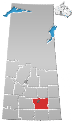
 Earl Grey Location of Earl Grey  Earl Grey Earl Grey (Canada) | |
| Coordinates: 50°56′08″N 104°42′40″W | |
| Country | |
| Province | |
| Region | Central |
| Census division | 6 |
| Rural Municipality | Longlaketon No. 219 |
| Post office Founded | 1905-10-16 |
| Incorporated (Village) | 1906 |
| Government | |
| • Type | Municipal |
| • Governing body | Earl Grey Village Council |
| • Mayor | Debbie Hupka-Butz |
| • Administrator | Courtney Wiers |
| Population (2006) | |
| • Total | 246 |
| • Density | 187.7/km2 (486/sq mi) |
| Time zone | UTC-6 (CST) |
| Postal code | S0G 1J0 |
| Area code(s) | 306 |
| Highways | |
| Railways | Canadian Pacific Railway (abandoned) |
The area was first settled in 1901 by Paul Henderson, younger brother of Jack Henderson, hangman of Louis Riel.[1] Subsequent to Paul Henderson's death from exposure in 1903, other settlers followed; in 1906 the village was incorporated and named "Earl Grey" after Albert Grey, 4th Earl Grey, Canada's Governor General at the time.[2]
Currently, the town has two churches (Christ Lutheran Church (ELCIC) and a United Church), one Kingdom Hall of Jehovah's Witnesses, several old-age homes, a hotel, a curling rink, and a veterinary clinic. A small statue of a grain elevator is displayed in the downtown area, a commemorative tribute to the village's once-thriving grain economy.
The public school was downsized to a Kindergarten-Grade 8 school in the 2003–2004 school year, before closing completely in 2007.[3]
History
Earl Grey incorporated as a village on July 27, 1906.[4]
Demographics
In the 2016 Census of Population conducted by Statistics Canada, the Village of Earl Grey recorded a population of 246 living in 118 of its 121 total private dwellings, a 2.8% change from its 2011 population of 239. With a land area of 1.31 km2 (0.51 sq mi), it had a population density of 187.8/km2 (486.4/sq mi) in 2016.[7]
In the 2011 Census of Population, the Village of Earl Grey recorded a population of 239, a -9.5% change from its 2006 population of 264. With a land area of 1.31 km2 (0.51 sq mi), it had a population density of 182.4/km2 (472.5/sq mi) in 2011.[8]
See also
- List of communities in Saskatchewan
- Villages of Saskatchewan
References
- Black, Norman Fergus (1913). A HISTORY OF SASKATCHEWAN AND THE OLD NORTH WEST.
- Shortt, Adam & Doughty, Arthur G., editors (1914). Canada and Its Provinces: Volume 19: The Prairie Provinces Part One
- Sask. school divisions announce 14 closures May 8, 2007 - CBC News. Retrieved July 29, 2019
- "Urban Municipality Incorporations". Saskatchewan Ministry of Government Relations. Archived from the original on October 15, 2014. Retrieved June 1, 2020.
- "Saskatchewan Census Population" (PDF). Saskatchewan Bureau of Statistics. Archived from the original (PDF) on September 24, 2015. Retrieved May 31, 2020.
- "Saskatchewan Census Population". Saskatchewan Bureau of Statistics. Retrieved May 31, 2020.
- "Population and dwelling counts, for Canada, provinces and territories, and census subdivisions (municipalities), 2016 and 2011 censuses – 100% data (Saskatchewan)". Statistics Canada. February 8, 2017. Retrieved May 30, 2020.
- "Population and dwelling counts, for Canada, provinces and territories, and census subdivisions (municipalities), 2011 and 2006 censuses (Saskatchewan)". Statistics Canada. June 3, 2019. Retrieved May 30, 2020.