Macoun, Saskatchewan
Macoun (2016 population: 269) is a village in the Canadian province of Saskatchewan within the Rural Municipality of Cymri No. 36 and Census Division No. 2. The village is located 28 km (17.2 miles) northwest of the City of Estevan on Highway 39.
Macoun | |
|---|---|
Village | |
 Macoun Location of Macoun in Saskatchewan  Macoun Macoun (Canada) | |
| Coordinates: 49.293°N 103.279°W | |
| Country | Canada |
| Province | Saskatchewan |
| Region | Saskatchewan |
| Census division | 2 |
| Rural Municipality | Cymri No. 36 |
| Post office Founded | 1903-09-01 |
| Government | |
| • Mayor | Glenys Bareg[1] |
| • Administrator | Carmen Dodd-Vicary |
| • Governing body | Macoun Village Council |
| Area | |
| • Total | 1.68 km2 (0.65 sq mi) |
| Population (2011)[2] | |
| • Total | 246 |
| • Density | 146.1/km2 (378/sq mi) |
| Time zone | CST |
| Postal code | S0C 1P0 |
| Area code(s) | 306 |
| Highways | Highway 39 |
| [3][4][5][6] | |
History
Macoun incorporated as a village on October 16, 1903.[7] An acetylene gas plant explosion in the cellar of the Macoun Hotel and the resulting fire on April 20, 1914 caused the death of 13 people.[8] In the early 1900s acetylene was widely used for illumination.
Notable residents
Notable people from Macoun include:
- Leonard Gustafson, Canadian senator
- Kim Thorson, politician
Demographics
In the 2016 Census of Population conducted by Statistics Canada, the Village of Macoun recorded a population of 269 living in 103 of its 119 total private dwellings, a 8.6% change from its 2011 population of 246. With a land area of 1.68 km2 (0.65 sq mi), it had a population density of 160.1/km2 (414.7/sq mi) in 2016.[11]
In the 2011 Census of Population, the Village of Macoun recorded a population of 246, a 46.4% change from its 2006 population of 168. With a land area of 1.68 km2 (0.65 sq mi), it had a population density of 146.4/km2 (379.2/sq mi) in 2011.[12]
See also
- List of communities in Saskatchewan
- Villages of Saskatchewan
References
- Municipal Directory System
- "2011 Community Profiles". Statistics Canada. Government of Canada. Retrieved 2014-08-15.
- National Archives, Archivia Net. "Post Offices and Postmasters". Archived from the original on 2006-10-06. Retrieved 2014-08-15.
- Government of Saskatchewan, MRD Home. "Municipal Directory System". Archived from the original on 2016-01-15. Retrieved 2014-08-15.
- Canadian Textiles Institute. (2005), CTI Determine your provincial constituency, archived from the original on 2007-09-11
- Commissioner of Canada Elections, Chief Electoral Officer of Canada (2005), Elections Canada On-line, archived from the original on 2007-04-21
- "Urban Municipality Incorporations". Saskatchewan Ministry of Government Relations. Archived from the original on October 15, 2014. Retrieved June 1, 2020.
- Poverty Bay Herald, Volume XLI, Issue 13394, 30 May 1914, Page 10. "HOTEL FIRE". Retrieved 2014-08-15.CS1 maint: multiple names: authors list (link)
- "Saskatchewan Census Population" (PDF). Saskatchewan Bureau of Statistics. Archived from the original (PDF) on September 24, 2015. Retrieved May 31, 2020.
- "Saskatchewan Census Population". Saskatchewan Bureau of Statistics. Retrieved May 31, 2020.
- "Population and dwelling counts, for Canada, provinces and territories, and census subdivisions (municipalities), 2016 and 2011 censuses – 100% data (Saskatchewan)". Statistics Canada. February 8, 2017. Retrieved May 30, 2020.
- "Population and dwelling counts, for Canada, provinces and territories, and census subdivisions (municipalities), 2011 and 2006 censuses (Saskatchewan)". Statistics Canada. June 3, 2019. Retrieved May 30, 2020.
Places adjacent to Macoun, Saskatchewan | ||||||||||
|---|---|---|---|---|---|---|---|---|---|---|
| ||||||||||
| Cities | 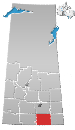 | ||||||
|---|---|---|---|---|---|---|---|
| Towns | |||||||
| Villages | |||||||
| Rural municipalities | |||||||
| First Nations | |||||||
| Indian reserves | |||||||
| Unincorporated communities |
| ||||||