Codette
Codette (2016 population: 198) is a village in the Canadian province of Saskatchewan within the Rural Municipality of Nipawin No. 487 and Census Division No. 14. The village is located 10 km south of Nipawin at the junction of Highway 35 and Highway 789.
Codette | |
|---|---|
| Village of Codette | |
 Codette Location of Codette in Saskatchewan  Codette Codette (Canada) | |
| Coordinates: 53.164407°N 104.013320°W | |
| Country | |
| Province | |
| Region | East-central |
| Census division | 14 |
| Rural Municipality | Nipawin No. 487 |
| Government | |
| • Type | Municipal |
| • Governing body | Codette Village Council |
| • Mayor | Malcolm Haveroen |
| • Administrator | Nathalie Hipkins |
| Area | |
| • Land | 0.37 km2 (0.14 sq mi) |
| Population (2016) | |
| • Total | 198 |
| • Density | 539.2/km2 (1,397/sq mi) |
| Time zone | UTC-6 (CST) |
| Postal code | S0E 0P0 |
| Area code(s) | 306 |
| Highways | |
History
Codette incorporated as a village on March 9, 1929.[1] The community shares its name with nearby Codette Lake, a man-made lake on the Saskatchewan River, blocked by the Francois Finlay Dam.
Demographics
In the 2016 Census of Population conducted by Statistics Canada, the Village of Codette recorded a population of 198 living in 103 of its 105 total private dwellings, a -3.5% change from its 2011 population of 205. With a land area of 0.37 km2 (0.14 sq mi), it had a population density of 535.1/km2 (1,386.0/sq mi) in 2016.[4]
In the 2011 Census of Population, the Village of Codette recorded a population of 205, a -7.2% change from its 2006 population of 221. With a land area of 0.37 km2 (0.14 sq mi), it had a population density of 554.1/km2 (1,435.0/sq mi) in 2011.[5]
See also
- List of communities in Saskatchewan
- Villages of Saskatchewan
References
- "Urban Municipality Incorporations". Saskatchewan Ministry of Government Relations. Archived from the original on October 15, 2014. Retrieved June 1, 2020.
- "Saskatchewan Census Population" (PDF). Saskatchewan Bureau of Statistics. Archived from the original (PDF) on September 24, 2015. Retrieved May 31, 2020.
- "Saskatchewan Census Population". Saskatchewan Bureau of Statistics. Retrieved May 31, 2020.
- "Population and dwelling counts, for Canada, provinces and territories, and census subdivisions (municipalities), 2016 and 2011 censuses – 100% data (Saskatchewan)". Statistics Canada. February 8, 2017. Retrieved May 30, 2020.
- "Population and dwelling counts, for Canada, provinces and territories, and census subdivisions (municipalities), 2011 and 2006 censuses (Saskatchewan)". Statistics Canada. June 3, 2019. Retrieved May 30, 2020.
| Cities | 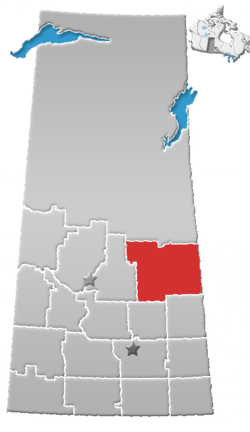 | |
|---|---|---|
| Towns | ||
| Villages | ||
| Resort villages | ||
| Rural municipalities |
| |
| First Nations | ||
| Indian reserves | ||
| Unincorporated communities | ||