Drinkwater, Saskatchewan
Drinkwater (2016 population: 70) is a village in the Canadian province of Saskatchewan within the Rural Municipality of Redburn No. 130 and Census Division No. 6. The village is located along Highway 39 along the branch of the Canadian Pacific Railway, 18 miles southeast of the City of Moose Jaw and is named for "Charles Drinkwater", an original director of the CP Railway.
Drinkwater | |
|---|---|
| Village of Drinkwater | |
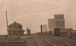 Canadian Pacific Railway Station, Drinkwater, ca. 1908 | |
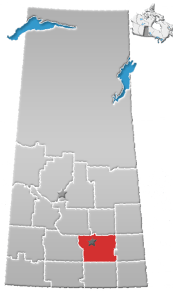
 Location of Drinkwater in Saskatchewan  Drinkwater, Saskatchewan (Canada) | |
| Coordinates: 50°17′44″N 105°08′09″W | |
| Country | |
| Province | |
| Region | Southeast |
| Census division | 13 |
| Rural Municipality | Redburn No. 130 |
| Government | |
| • Type | Municipal |
| • Governing body | Drinkwater Village Council |
| • Mayor | Ryan Briggs |
| • Administrator | Colleen Ferguson |
| Area | |
| • Total | 2.64 km2 (1.02 sq mi) |
| Population (2016) | |
| • Total | 70 |
| • Density | 26.5/km2 (69/sq mi) |
| Time zone | UTC-6 (CST) |
| Postal code | S0H 1G0 |
| Area code(s) | 306 |
| Highways | |
| Railways | Canadian Pacific Railway |
| [1][2][3][4] | |
History
Drinkwater incorporated as a village on June 7, 1904.[5]
Demographics
In the 2016 Census of Population conducted by Statistics Canada, the Village of Drinkwater recorded a population of 70 living in 27 of its 32 total private dwellings, a 7.1% change from its 2011 population of 65. With a land area of 2.64 km2 (1.02 sq mi), it had a population density of 26.5/km2 (68.7/sq mi) in 2016.[8]
In the 2011 Census of Population, the Village of Drinkwater recorded a population of 65, a 0% change from its 2006 population of 65. With a land area of 2.64 km2 (1.02 sq mi), it had a population density of 24.6/km2 (63.8/sq mi) in 2011.[9]
Attractions
- Sanborn Round Barn[10]
Location
See also
- List of communities in Saskatchewan
- Villages of Saskatchewan
References
- National Archives, Archivia Net, Post Offices and Postmasters, archived from the original on 2006-10-06
- Government of Saskatchewan, MRD Home, Municipal Directory System, archived from the original (– Scholar search) on November 21, 2008
- Canadian Textiles Institute. (2005), CTI Determine your provincial constituency, archived from the original on 2007-09-11
- Commissioner of Canada Elections, Chief Electoral Officer of Canada (2005), Elections Canada On-line, archived from the original on 2007-04-21
- "Urban Municipality Incorporations". Saskatchewan Ministry of Government Relations. Archived from the original on October 15, 2014. Retrieved June 1, 2020.
- "Saskatchewan Census Population" (PDF). Saskatchewan Bureau of Statistics. Archived from the original (PDF) on September 24, 2015. Retrieved May 31, 2020.
- "Saskatchewan Census Population". Saskatchewan Bureau of Statistics. Retrieved May 31, 2020.
- "Population and dwelling counts, for Canada, provinces and territories, and census subdivisions (municipalities), 2016 and 2011 censuses – 100% data (Saskatchewan)". Statistics Canada. February 8, 2017. Retrieved May 30, 2020.
- "Population and dwelling counts, for Canada, provinces and territories, and census subdivisions (municipalities), 2011 and 2006 censuses (Saskatchewan)". Statistics Canada. June 3, 2019. Retrieved May 30, 2020.
- Sanborn Round Barn - Drinkwater, Saskatchewan
- Government of Canada, Archivia Net, Post Offices and Postmasters, archived from the original on 2006-10-06, retrieved 2007-05-05
Places adjacent to Drinkwater, Saskatchewan | ||||||||||
|---|---|---|---|---|---|---|---|---|---|---|
| ||||||||||