Smiley, Saskatchewan
Smiley (2016 population: 60) is a village in the Canadian province of Saskatchewan within the Rural Municipality of Prairiedale No. 321 and Census Division No. 13. The village is located approximately 20 km northwest of the Town of Kindersley at the intersection of Highway 307 and Highway 772. The Grand Trunk Pacific Railway was completed in 1913 bringing an economic boom to the village's early years. On April 26, 1987 the Dodsland subdivision between Dodsland and Smiley was transferred to the Canadian Pacific Railway.[5] Due to the close proximity to major grain centres such as Kindersley, CPR put the line up for abandonment and was granted permission to remove the track by the Canadian Transportation Agency on October 29, 1997.[6]
Smiley, Saskatchewan | |
|---|---|
 Location of Smiley in Saskatchewan  Smiley, Saskatchewan (Canada) | |
| Coordinates: 51.3803°N 109.2813°W | |
| Country | Canada |
| Province | Saskatchewan |
| Region | West-central |
| Census division | 13 |
| Rural Municipality | Prairiedale Website - www.major.ca |
| Government | |
| • Governing body | Smiley Village Council |
| Area | |
| • Total | 0.64 km2 (0.25 sq mi) |
| Population (2006) | |
| • Total | 50 |
| • Density | 77.8/km2 (202/sq mi) |
| Time zone | CST |
| Postal code | S0L 2Z0 |
| Area code(s) | 306 |
| Highways | Highway 51 |
| Railway | Canadian National Railway - Transferred to Canadian Pacific Railway - Abandoned 1997 |
| [1][2][3][4] | |
An F3 tornado struck here leaving a 10-kilometre path and taking two unknown lives on July 6, 1935.
History
Smiley incorporated as a village on November 26, 1913.[7]
Demographics
In the 2016 Census of Population conducted by Statistics Canada, the Village of Smiley recorded a population of 60 living in 26 of its 37 total private dwellings, a 0% change from its 2011 population of 60. With a land area of 0.64 km2 (0.25 sq mi), it had a population density of 93.8/km2 (242.8/sq mi) in 2016.[10]
In the 2011 Census of Population, the Village of Smiley recorded a population of 60, a 20% change from its 2006 population of 50. With a land area of 0.64 km2 (0.25 sq mi), it had a population density of 93.8/km2 (242.8/sq mi) in 2011.[11]
Attractions
- Great Wall of Saskatchewan, a 1.6-kilometre-long (0.99 mi), three-metre-wide (9.8 ft), two-metre-high (6.6 ft) wall that took over 30 years to construct by Albert “Stonewall” Johnson. The wall is made entirely of stones without the use of cement or mortar, for aesthetic purposes.[12]
See also
- List of communities in Saskatchewan
- Hamlets of Saskatchewan
References
- National Archives, Archivia Net, Post Offices and Postmasters
- Government of Saskatchewan, MRD Home, Municipal Directory System, archived from the original (– Scholar search) on November 21, 2008
- Canadian Textiles Institute. (2005), CTI Determine your provincial constituency, archived from the original on 2007-09-11
- Commissioner of Canada Elections, Chief Electoral Officer of Canada (2005), Elections Canada On-line
- "Smiley - Railway 87". Retrieved 2012-05-25.
- CTA. "Smiley - Railway". Retrieved 2012-05-25.
- "Urban Municipality Incorporations". Saskatchewan Ministry of Government Relations. Archived from the original on October 15, 2014. Retrieved June 1, 2020.
- "Saskatchewan Census Population" (PDF). Saskatchewan Bureau of Statistics. Archived from the original (PDF) on September 24, 2015. Retrieved May 31, 2020.
- "Saskatchewan Census Population". Saskatchewan Bureau of Statistics. Retrieved May 31, 2020.
- "Population and dwelling counts, for Canada, provinces and territories, and census subdivisions (municipalities), 2016 and 2011 censuses – 100% data (Saskatchewan)". Statistics Canada. February 8, 2017. Retrieved May 30, 2020.
- "Population and dwelling counts, for Canada, provinces and territories, and census subdivisions (municipalities), 2011 and 2006 censuses (Saskatchewan)". Statistics Canada. June 3, 2019. Retrieved May 30, 2020.
- Saskbiz Community Profiles - Great Wall of Saskatchewan
Places adjacent to Smiley, Saskatchewan | |
|---|---|
| Towns | 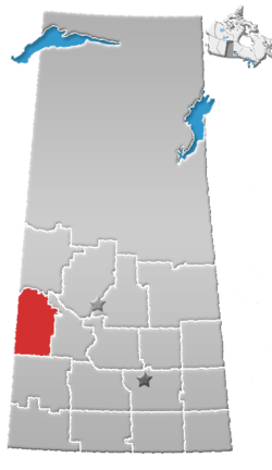 | ||||
|---|---|---|---|---|---|
| Villages | |||||
| Rural municipalities |
| ||||
| First Nations | |||||
| Indian reserves | |||||
| Unincorporated communities |
| ||||