Minton, Saskatchewan
Minton (2016 population: 55) is a village in the Canadian province of Saskatchewan within the Rural Municipality of Surprise Valley No. 9 and Census Division No. 2. It is on Highway 6 just north of its intersection with Highway 18, 19 km north of the Raymond-Regway Border Crossing on the Montana-Saskatchewan border. The village was named after Minton, Shropshire in England. The name was given by the Canadian Pacific Railway.[1]
Village of Minton | |
|---|---|
Village | |
 Location of Minton in Saskatchewan  Minton, Saskatchewan (Canada) | |
| Coordinates: 49.167°N 104.586°W | |
| Country | Canada |
| Province | Saskatchewan |
| Region | Saskatchewan |
| Census division | 2 |
| Rural Municipality | Surprise Valley |
| Post office Founded | 1930[1] |
| Incorporated (Village) | N/A |
| Incorporated (Town) | N/A |
| Government | |
| • Mayor | Dennis Simpart |
| • Administrator | Joyce Axten |
| • Governing body | Minton Village Council |
| Area | |
| • Total | 0.30 km2 (0.12 sq mi) |
| Population (2006) | |
| • Total | 60 |
| • Density | 319.8/km2 (828/sq mi) |
| Time zone | CST |
| Postal code | S0C 1T0 |
| Area code(s) | 306 |
| Highways | Highway 6, Highway 18, Highway 676 |
| [2][3][4][5] | |
History
Minton incorporated as a village on January 1, 1951.[6]
Demographics
In the 2016 Census of Population conducted by Statistics Canada, the Village of Minton recorded a population of 55 living in 25 of its 32 total private dwellings, a -9.1% change from its 2011 population of 60. With a land area of 0.3 km2 (0.12 sq mi), it had a population density of 183.3/km2 (474.8/sq mi) in 2016.[9]
In the 2011 Census of Population, the Village of Minton recorded a population of 60, a 0% change from its 2006 population of 60. With a land area of 0.3 km2 (0.12 sq mi), it had a population density of 200.0/km2 (518.0/sq mi) in 2011.[10]
Attractions
There is an Inukshuk monument approximately 8 km north of Minton on highway #6. It is 50 metre east of the highway at coordinates 49 13.901 N, 104 36.358 W just off of the gravel road.
See also
- List of communities in Saskatchewan
- Villages of Saskatchewan
Footnotes
- Barry, Bill (September 2005). Geographic Names of Saskatchewan. Regina, Saskatchewan: People Places Publishing, Ltd. p. 286. ISBN 1-897010-19-2.
- National Archives, Archivia Net, Post Offices and Postmasters, archived from the original on 2006-10-06
- Government of Saskatchewan, MRD Home, Municipal Directory System, archived from the original (– Scholar search) on November 21, 2008
- Canadian Textiles Institute. (2005), CTI Determine your provincial constituency, archived from the original on 2007-09-11
- Commissioner of Canada Elections, Chief Electoral Officer of Canada (2005), Elections Canada On-line, archived from the original on 2007-04-21
- "Urban Municipality Incorporations". Saskatchewan Ministry of Government Relations. Archived from the original on October 15, 2014. Retrieved June 1, 2020.
- "Saskatchewan Census Population" (PDF). Saskatchewan Bureau of Statistics. Archived from the original (PDF) on September 24, 2015. Retrieved May 31, 2020.
- "Saskatchewan Census Population". Saskatchewan Bureau of Statistics. Retrieved May 31, 2020.
- "Population and dwelling counts, for Canada, provinces and territories, and census subdivisions (municipalities), 2016 and 2011 censuses – 100% data (Saskatchewan)". Statistics Canada. February 8, 2017. Retrieved May 30, 2020.
- "Population and dwelling counts, for Canada, provinces and territories, and census subdivisions (municipalities), 2011 and 2006 censuses (Saskatchewan)". Statistics Canada. June 3, 2019. Retrieved May 30, 2020.
| Cities | 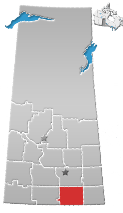 | ||||||
|---|---|---|---|---|---|---|---|
| Towns | |||||||
| Villages | |||||||
| Rural municipalities | |||||||
| First Nations | |||||||
| Indian reserves | |||||||
| Unincorporated communities |
| ||||||