Marshfield, Missouri
Marshfield is a city in and the county seat of Webster County, Missouri. As of the 2010 census, the city population was 6,633.[6] As of 2019, Marshfield had a population of 7,562 (U.S. Census Bureau estimate). It is part of the Springfield, Missouri, Metropolitan Area.[7]
Marshfield, Missouri | |
|---|---|
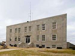 Webster County Courthouse, 2006 | |
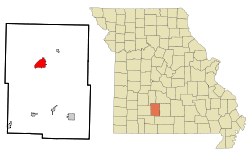 Location of Marshfield, Missouri | |
| Coordinates: 37°20′23″N 92°54′26″W | |
| Country | United States |
| State | Missouri |
| County | Webster |
| Government | |
| • Mayor | Robert Williams |
| • City Administrator | John Benson |
| Area | |
| • Total | 5.03 sq mi (13.03 km2) |
| • Land | 5.03 sq mi (13.03 km2) |
| • Water | 0 sq mi (0 km2) |
| Elevation | 1,493 ft (455 m) |
| Population | |
| • Total | 6,633 |
| • Estimate (2019)[3] | 7,562 |
| • Density | 1,300/sq mi (510/km2) |
| Time zone | UTC-6 (Central (CST)) |
| • Summer (DST) | UTC-5 (CDT) |
| ZIP code | 65706 |
| Area code(s) | Area code 573 Exchanges: 468,859 |
| FIPS code | 29-46388[4] |
| GNIS feature ID | 0721909[5] |
| Website | marshfieldmo.gov |
History
Marshfield was platted in 1855, taking its name from Marshfield, Massachusetts.[8] A post office called Marshfield has been in operation since 1856.[9]
The Hosmer Dairy Farm Historic District and Rainey Funeral Home Building are listed on the National Register of Historic Places.[10][11]
Geography
Marshfield is located at 37°20′23″N 92°54′26″W (37.339599, -92.907230).[12] According to the United States Census Bureau, the city has a total area of 5.03 square miles (13.03 km2), all land.[1]
Demographics
| Historical population | |||
|---|---|---|---|
| Census | Pop. | %± | |
| 1860 | 408 | — | |
| 1870 | 809 | 98.3% | |
| 1880 | 655 | −19.0% | |
| 1890 | 980 | 49.6% | |
| 1900 | 964 | −1.6% | |
| 1910 | 1,193 | 23.8% | |
| 1920 | 1,371 | 14.9% | |
| 1930 | 1,378 | 0.5% | |
| 1940 | 1,764 | 28.0% | |
| 1950 | 1,925 | 9.1% | |
| 1960 | 2,221 | 15.4% | |
| 1970 | 2,961 | 33.3% | |
| 1980 | 3,871 | 30.7% | |
| 1990 | 4,374 | 13.0% | |
| 2000 | 5,720 | 30.8% | |
| 2010 | 6,633 | 16.0% | |
| Est. 2019 | 7,562 | [3] | 14.0% |
| U.S. Decennial Census | |||
2010 census
At the 2010 census there were 6,633 people, 2,605 households, and 1,756 families living in the city. The population density was 1,318.7 inhabitants per square mile (509.2/km2). There were 2,918 housing units at an average density of 580.1 per square mile (224.0/km2). The racial makeup of the city was 96.5% White, 0.4% African American, 0.8% Native American, 0.2% Asian, 0.5% from other races, and 1.7% from two or more races. Hispanic or Latino of any race were 1.7%.[2]
Of the 2,605 households 37.0% had children under the age of 18 living with them, 49.0% were married couples living together, 14.0% had a female householder with no husband present, 4.4% had a male householder with no wife present, and 32.6% were non-families. 28.9% of households were one person and 14.8% were one person aged 65 or older. The average household size was 2.47 and the average family size was 3.04.
The median age was 36.4 years. 27.6% of residents were under the age of 18; 8.5% were between the ages of 18 and 24; 24.3% were from 25 to 44; 21.9% were from 45 to 64; and 17.7% were 65 or older. The gender makeup of the city was 47.1% male and 52.9% female.
2000 census
At the 2000 census there were 5,720 people, 2,256 households, and 1,534 families living in the city. The population density was 1,182.7 people per square mile (456.3/km²). There were 2,417 housing units at an average density of 499.8/sq mi (192.8/km²). The racial makeup of the city was 97.80% White, 0.19% African American, 0.42% Native American, 0.30% Asian, 0.12% from other races, and 1.17% from two or more races. Hispanic or Latino of any race were 1.75%.[4]
Of the 2,256 households 34.7% had children under the age of 18 living with them, 53.2% were married couples living together, 11.4% had a female householder with no husband present, and 32.0% were non-families. 28.7% of households were one person and 16.0% were one person aged 65 or older. The average household size was 2.44 and the average family size was 3.00.
The age distribution was 27.1% under the age of 18, 9.4% from 18 to 24, 27.2% from 25 to 44, 18.2% from 45 to 64, and 18.1% 65 or older. The median age was 35 years. For every 100 females, there were 85.0 males. For every 100 females age 18 and over, there were 79.3 males.
As of 2000, The median household income was $27,753, and the median family income was $36,090. Males had a median income of $27,813 versus $20,752 for females. The per capita income for the city was $14,855. About 5.5% of families and 11.6% of the population were below the poverty line, including 10.2% of those under age 18 and 12.2% of those age 65 or over.
Education
Marshfield has one public high school, Marshfield High School. Marshfield Christian School is a private institution.
Marshfield has a lending library, a branch of the Webster County Library.[13]
Government
As of April 2020, the current mayor of Marshfield is Robert Williams and the current city administrator is John Benson.[14][15]
Notable people
- Joseph Sterling Bridwell, Texas oilman, rancher, and philanthropist, attended school in Marshfield in the 1890s.[16]
- Dan Clemens, Republican member of the Missouri State Senate, was reared in and lived in Marshfield.
- Joe Haymes, Swing Era orchestra leader, was born in Marshfield in 1907.
- Edwin Hubble, American astronomer. Part of Interstate 44 through Marshfield is named the Edwin Hubble Highway.
- Darren King, member of the band Mutemath, was reared in Marshfield.
References
- "US Gazetteer files 2010". United States Census Bureau. Archived from the original on 2012-07-02. Retrieved 2012-07-08.
- "U.S. Census website". United States Census Bureau. Retrieved 2012-07-08.
- https://www.census.gov/quickfacts/fact/table/marshfieldcitymissouri/PST045218
- "U.S. Census website". United States Census Bureau. Retrieved 2008-01-31.
- "US Board on Geographic Names". United States Geological Survey. 2007-10-25. Retrieved 2008-01-31.
- "2010 City Population and Housing Occupancy Status". U.S. Census Bureau. Retrieved July 9, 2012.
- "Find a County". National Association of Counties. Retrieved 2011-06-07.
- "Webster County Place Names, 1928–1945". The State Historical Society of Missouri. Archived from the original on June 24, 2016. Retrieved January 2, 2017.
- "Post Offices". Jim Forte Postal History. Retrieved 1 January 2017.
- "National Register Information System". National Register of Historic Places. National Park Service. July 9, 2010.
- "National Register of Historic Places Listings". Weekly List of Actions Taken on Properties: 1/21/14 through 1/24/14. National Park Service. 2014-01-31.
- "US Gazetteer files: 2010, 2000, and 1990". United States Census Bureau. 2011-02-12. Retrieved 2011-04-23.
- "About Us". Webster County Library. Retrieved 1 June 2019.
- "Mayor & Aldermen". City of Marshfield. Retrieved April 12, 2020.
- "Administration". City of Marshfield. Retrieved April 12, 2020.
- "Jack O. Loftin, "Joseph Sterling Bridwell"". Texas State Historical Association online. Retrieved April 30, 2013.
External links
| Wikimedia Commons has media related to Marshfield, Missouri. |
- City of Marshfield
- Marshfield Mail newspaper
- A Directory of Towns, Villages, and Hamlets, Past and Present of Webster County, Missouri
- Historic maps of Marshfield in the Sanborn Maps of Missouri Collection at the University of Missouri
- Marshfield, MO Tornado, Apr 1880 at GenDisasters.com
Municipalities and communities of Webster County, Missouri, United States | ||
|---|---|---|
| Cities | 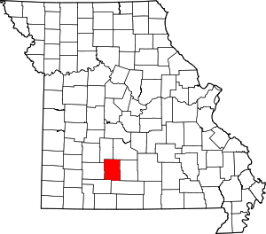 Map of Missouri highlighting Webster County | |
| Village | ||
| Townships |
| |
| Unincorporated communities | ||
| Ghost towns | ||
| Footnotes | ‡This populated place also has portions in an adjacent county or counties | |

| Authority control |
|
|---|