Gentry County, Missouri
Gentry County is a county located in the northwestern portion of the U.S. state of Missouri. As of the 2010 census, the population was 6,738.[1] Its county seat is Albany.[2] The county was organized February 14, 1841[3] and named for Colonel Richard Gentry[4] of Boone County, who fell in the Seminole War in 1837.
Gentry County | |
|---|---|
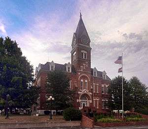 Gentry County Courthouse in Albany | |
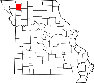 Location within the U.S. state of Missouri | |
 Missouri's location within the U.S. | |
| Coordinates: 40°13′N 94°25′W | |
| Country | |
| State | |
| Founded | February 14, 1841 |
| Named for | Richard Gentry |
| Seat | Albany |
| Largest city | Albany |
| Area | |
| • Total | 492 sq mi (1,270 km2) |
| • Land | 491 sq mi (1,270 km2) |
| • Water | 0.3 sq mi (0.8 km2) 0.06% |
| Population (2010) | |
| • Total | 6,738 |
| • Estimate (2018) | 6,628 |
| • Density | 14/sq mi (5.3/km2) |
| Time zone | UTC−6 (Central) |
| • Summer (DST) | UTC−5 (CDT) |
| Congressional district | 6th |
| Website | gentrycounty |
Geography
According to the U.S. Census Bureau, the county has a total area of 492 square miles (1,270 km2), of which 491 square miles (1,270 km2) is land and 0.3 square miles (0.78 km2) (0.06%) is water.[5]
Adjacent counties
- Worth County (north)
- Harrison County (east)
- Daviess County (southeast)
- DeKalb County (south)
- Andrew County (southwest)
- Nodaway County (west)
Major highways


Demographics
| Historical population | |||
|---|---|---|---|
| Census | Pop. | %± | |
| 1850 | 4,248 | — | |
| 1860 | 11,862 | 179.2% | |
| 1870 | 11,607 | −2.1% | |
| 1880 | 17,176 | 48.0% | |
| 1890 | 19,018 | 10.7% | |
| 1900 | 20,554 | 8.1% | |
| 1910 | 16,820 | −18.2% | |
| 1920 | 15,634 | −7.1% | |
| 1930 | 14,348 | −8.2% | |
| 1940 | 13,359 | −6.9% | |
| 1950 | 11,036 | −17.4% | |
| 1960 | 8,793 | −20.3% | |
| 1970 | 8,060 | −8.3% | |
| 1980 | 7,887 | −2.1% | |
| 1990 | 6,848 | −13.2% | |
| 2000 | 6,861 | 0.2% | |
| 2010 | 6,738 | −1.8% | |
| Est. 2018 | 6,628 | [6] | −1.6% |
| U.S. Decennial Census[7] 1790-1960[8] 1900-1990[9] 1990-2000[10] 2010-2015[1] | |||
As of the census[11] of 2010, there were 6,738 people, 2,674 households, and 1,789 families residing in the county. The population density was 14 people per square mile (5/km²). There were 3,209 housing units at an average density of 6 per square mile (3/km²). The racial makeup of the county was 98.38% White, 0.31% Black or African American, 0.27% Asian, 0.19% Native American, 0.16% from other races, and 0.68% from two or more races. 0.53% of the population were Hispanic or Latino of any race.
There were 2,674 households, of which 29.06% had children under the age of 18 living with them, 55.42% were married couples living together, 8.23% had a female householder with no husband present, and 33.10% were non-families. 29.02% of all households were made up of individuals and 15.07% had someone living alone who was 65 years of age or older. The average household size was 2.45 and the average family size was 3.03.
In the county, the population was spread out with 24.55% under the age of 18, 7.85% from 18 to 24, 20.67% from 25 to 44, 26.43% from 45 to 64, and 20.50% who were 65 years of age or older. The median age was 42.4 years. For every 100 females there were 93.62 males. For every 100 females age 18 and over, there were 92.43 males.
The median income for a household in the county was $35,556, and the median income for a family was $46,458. Males had a median income of $33,558 versus $25,815 for females. The per capita income for the county was $19,021. About 9.30% of families and 14.90% of the population were below the poverty line, including 24.40% of those under age 18 and 15.00% of those age 65 or over.
Religion
According to the Association of Religion Data Archives County Membership Report (2010), Gentry County is sometimes regarded as being on the northern edge of the Bible Belt, with evangelical Protestantism being the most predominant religion. The most predominant denominations among residents in Gentry County who adhere to a religion are Southern Baptists (46.29%), United Methodists (18.20%), and Disciples of Christ (13.12%).
Education
Public schools
- Albany R-III School District – Albany
- Virginia E. George Elementary School (PK-05)
- Albany Middle School (06-08)
- Albany High School (09-12)
- King City R-I School District – King City
- King City Elementary School (PK-06)
- King City High School (07-12)
- Stanberry R-II School District – Stanberry
- Stanberry Elementary School (K-06)
- Stanberry High School (07-12)
Politics
Local
The Democratic Party controls politics at the local level in Gentry County. Democrats hold all but three of the elected positions in the county.
| Gentry County, Missouri | ||||
|---|---|---|---|---|
| Elected countywide officials | ||||
| Assessor | Penny Woods | Republican | ||
| Circuit Clerk | Janet Parsons | Republican | ||
| County Clerk | Carol Reidlinger | Democratic | ||
| Collector | Linda Combs | Democratic | ||
| Commissioner (Presiding) |
Rod Dollars | Republican | ||
| Commissioner (District 1) |
Larry B. Wilson | Democratic | ||
| Commissioner (District 2) |
Gary Carlson | Republican | ||
| Coroner | Andrew E. Lindner | Republican | ||
| Prosecuting Attorney | David Parman | Republican | ||
| Public Administrator | Jody L. Novak | Democratic | ||
| Recorder | Janet Parsons | Republican | ||
| Sheriff | Tim Davis | Democratic | ||
| Surveyor | John Dole | Democratic | ||
| Treasurer | Linda Combs | Democratic | ||
State
| Year | Republican | Democratic | Third Parties |
|---|---|---|---|
| 2016 | 64.07% 1,940 | 33.35% 1,010 | 2.58% 78 |
| 2012 | 47.92% 1,429 | 48.89% 1,458 | 3.19% 95 |
| 2008 | 42.98% 1,400 | 54.16% 1,764 | 2.86% 93 |
| 2004 | 57.61% 1,901 | 41.03% 1,354 | 1.36% 45 |
| 2000 | 49.24% 1,522 | 49.27% 1,523 | 2.12% 46 |
| 1996 | 29.67% 981 | 68.75% 2,273 | 1.57% 52 |
Gentry County is part of the 2nd district in the Missouri House of Representatives, currently held by J. Eggleston (R-Maysville).
| Party | Candidate | Votes | % | ± | |
|---|---|---|---|---|---|
| Republican | J. Eggleston | 2,659 | 100.00% | +47.32 | |
| Party | Candidate | Votes | % | ± | |
|---|---|---|---|---|---|
| Republican | J. Eggleston | 844 | 52.68% | -16.36 | |
| Democratic | Mike Waltemath | 758 | 47.32% | +47.32 | |
| Party | Candidate | Votes | % | ± | |
|---|---|---|---|---|---|
| Republican | Casey Guernsey | 1,951 | 69.04% | ||
| Independent | Jim Nash | 875 | 30.96% | ||
Gentry County is a part of Missouri's 12th District in the Missouri Senate and is currently represented by Dan Hegeman (R-Cosby).
| Party | Candidate | Votes | % | ± | |
|---|---|---|---|---|---|
| Republican | Dan Hegeman | 1,322 | 100.00% | ||
Federal
| Party | Candidate | Votes | % | ± | |
|---|---|---|---|---|---|
| Republican | Roy Blunt | 1,860 | 61.69% | +20.11 | |
| Democratic | Jason Kander | 1,025 | 34.00% | -15.26 | |
| Libertarian | Jonathan Dine | 68 | 2.25% | -6.91 | |
| Green | Johnathan McFarland | 35 | 1.16% | +1.16 | |
| Constitution | Fred Ryman | 27 | 0.90% | +0.90 | |
| Party | Candidate | Votes | % | ± | |
|---|---|---|---|---|---|
| Republican | Todd Akin | 1,235 | 41.58% | ||
| Democratic | Claire McCaskill | 1,463 | 49.26% | ||
| Libertarian | Jonathan Dine | 272 | 9.16% | ||
Gentry County is included in Missouri's 6th Congressional District and is currently represented by Sam Graves (R-Tarkio) in the U.S. House of Representatives.
| Party | Candidate | Votes | % | ± | |
|---|---|---|---|---|---|
| Republican | Sam Graves | 2,297 | 76.64% | +7.23 | |
| Democratic | David M. Blackwell | 623 | 20.79% | -4.30 | |
| Libertarian | Russ Lee Monchil | 45 | 1.50% | -4.00 | |
| Green | Mike Diel | 32 | 1.07% | +1.07 | |
| Party | Candidate | Votes | % | ± | |
|---|---|---|---|---|---|
| Republican | Sam Graves | 1,098 | 69.41% | -3.60 | |
| Democratic | Bill Hedge | 397 | 25.09% | +0.17 | |
| Libertarian | Russ Lee Monchil | 87 | 5.50% | +3.43 | |
| Party | Candidate | Votes | % | ± | |
|---|---|---|---|---|---|
| Republican | Sam Graves | 2,151 | 73.01% | ||
| Democratic | Kyle Yarber | 734 | 24.92% | ||
| Libertarian | Russ Lee Monchil | 61 | 2.07% | ||
Political culture
| Year | Republican | Democratic | Third parties |
|---|---|---|---|
| 2016 | 75.7% 2,304 | 19.9% 605 | 4.4% 134 |
| 2012 | 66.3% 1,988 | 31.2% 937 | 2.5% 74 |
| 2008 | 59.7% 1,964 | 37.5% 1,235 | 2.8% 93 |
| 2004 | 63.0% 2,085 | 36.3% 1,201 | 0.8% 26 |
| 2000 | 57.0% 1,771 | 40.9% 1,271 | 2.0% 63 |
| 1996 | 41.4% 1,361 | 45.4% 1,493 | 13.3% 437 |
| 1992 | 34.2% 1,272 | 40.8% 1,519 | 25.1% 933 |
| 1988 | 45.3% 1,554 | 54.5% 1,872 | 0.2% 7 |
| 1984 | 56.1% 2,047 | 43.9% 1,600 | |
| 1980 | 51.8% 2,005 | 44.5% 1,720 | 3.7% 144 |
| 1976 | 43.9% 1,772 | 55.7% 2,249 | 0.4% 14 |
| 1972 | 64.5% 2,984 | 35.5% 1,642 | |
| 1968 | 48.7% 2,286 | 46.7% 2,189 | 4.6% 216 |
| 1964 | 34.4% 1,677 | 65.6% 3,198 | |
| 1960 | 54.2% 2,888 | 45.8% 2,439 | |
| 1956 | 53.2% 3,020 | 46.9% 2,662 | |
| 1952 | 57.8% 3,429 | 42.2% 2,508 | |
| 1948 | 43.6% 2,633 | 56.4% 3,410 | 0.0% 1 |
| 1944 | 49.5% 2,970 | 50.4% 3,022 | 0.1% 8 |
| 1940 | 48.2% 3,446 | 51.6% 3,689 | 0.3% 19 |
| 1936 | 42.6% 3,115 | 57.1% 4,173 | 0.3% 18 |
| 1932 | 33.7% 1,877 | 66.1% 3,677 | 0.2% 9 |
| 1928 | 56.0% 3,506 | 43.7% 2,735 | 0.2% 15 |
| 1924 | 45.9% 3,318 | 49.2% 3,555 | 4.8% 349 |
| 1920 | 49.7% 3,442 | 48.7% 3,374 | 1.6% 113 |
| 1916 | 42.3% 1,823 | 55.8% 2,404 | 1.9% 81 |
| 1912 | 30.3% 1,268 | 54.3% 2,268 | 15.4% 645 |
| 1908 | 44.8% 1,882 | 53.2% 2,236 | 2.1% 88 |
| 1904 | 46.9% 2,060 | 49.1% 2,157 | 4.0% 174 |
| 1900 | 45.4% 2,185 | 51.1% 2,459 | 3.4% 165 |
| 1896 | 40.4% 2,000 | 58.7% 2,906 | 1.0% 47 |
| 1892 | 37.8% 1,607 | 47.2% 2,003 | 15.0% 638 |
| 1888 | 42.0% 1,623 | 52.7% 2,039 | 5.3% 205 |
At the presidential level, Gentry County is Republican-leaning. George W. Bush carried the county easily in 2000 and 2004. Bill Clinton was the last Democratic presidential nominee to carry Gentry County in 1996, and like many of the rural counties throughout Missouri, Gentry County strongly favored John McCain over Barack Obama in 2008.
Like most rural areas throughout northwest Missouri, voters in Gentry County generally adhere to socially and culturally conservative principles which tend to influence their Republican leanings. In 2004, Missourians voted on a constitutional amendment to define marriage as the union between a man and a woman—it overwhelmingly won in Gentry County with 79.9% of the vote. The initiative passed the state with 71% support from voters. In 2006, Missourians voted on a constitutional amendment to fund and legalize embryonic stem cell research in the state—it failed in Gentry County with 58.3% voting against the measure. The initiative narrowly passed the state with 51% of support from voters as Missouri became one of the first states in the nation to approve embryonic stem cell research. Despite Gentry County's longstanding tradition of supporting socially conservative platforms, voters in the county have a penchant for advancing populist causes like increasing the minimum wage. In 2006, Missourians voted on a proposition (Proposition B) to increase the minimum wage in the state to $6.50 an hour—it passed Gentry County with 63.3% of the vote. The proposition strongly passed every single county in Missouri with 78.99% voting in favor. (During the same election, voters in five other states also strongly approved increases in the minimum wage.)
Missouri presidential preference primaries
2012
In the 2012 Missouri Republican Presidential Primary, voters in Gentry County supported former U.S. Senator Rick Santorum (R-Pennsylvania), who finished first in the state at large, but eventually lost the nomination to former Governor Mitt Romney (R-Massachusetts). Delegates to the state convention were chosen at a county caucus, which selected a delegation favoring Santorum.
2008
- Former U.S. Senator Hillary Clinton (D-New York) received more votes, a total of 409, than any candidate from either party in Gentry County during the 2008 presidential primary.
| Gentry County, Missouri | |
|---|---|
| 2008 Republican primary in Missouri | |
| John McCain | 217 (36.90%) |
| Mike Huckabee | 182 (30.95%) |
| Mitt Romney | 155 (26.36%) |
| Ron Paul | 23 (3.91%) |
| Gentry County, Missouri | |
|---|---|
| 2008 Democratic primary in Missouri | |
| Hillary Clinton | 409 (53.32%) |
| Barack Obama | 312 (40.68%) |
| John Edwards (withdrawn) | 38 (4.95%) |
Miscellaneous
On March 5, 2010, a jury awarded seven neighboring farmers $11 million in damages from Premium Standard Farms over odors emanating from a hog farm of 4,300 acres (17 km2) that processes 200,000 hogs near Berlin in Gentry County - the largest such award in history.[15]
See also
- National Register of Historic Places listings in Gentry County, Missouri
References
- "State & County QuickFacts". United States Census Bureau. Archived from the original on June 7, 2011. Retrieved September 8, 2013.
- "Find a County". National Association of Counties. Archived from the original on May 31, 2011. Retrieved 2011-06-07.
- Eaton, David Wolfe (1916). How Missouri Counties, Towns and Streams Were Named. The State Historical Society of Missouri. pp. 169.
- Gannett, Henry (1905). The Origin of Certain Place Names in the United States. Govt. Print. Off. pp. 136.
- "2010 Census Gazetteer Files". United States Census Bureau. August 22, 2012. Archived from the original on October 21, 2013. Retrieved November 15, 2014.
- "Population and Housing Unit Estimates". Retrieved November 20, 2019.
- "U.S. Decennial Census". United States Census Bureau. Retrieved November 15, 2014.
- "Historical Census Browser". University of Virginia Library. Retrieved November 15, 2014.
- "Population of Counties by Decennial Census: 1900 to 1990". United States Census Bureau. Retrieved November 15, 2014.
- "Census 2000 PHC-T-4. Ranking Tables for Counties: 1990 and 2000" (PDF). United States Census Bureau. Retrieved November 15, 2014.
- "U.S. Census website". United States Census Bureau. Retrieved 2008-01-31.
- Breeding, Marshall. "Albany Carnegie Public Library". Libraries.org. Retrieved May 8, 2017.
- Breeding, Marshall. "Gentry County Library". Libraries.org. Retrieved May 8, 2017.
- Leip, David. "Dave Leip's Atlas of U.S. Presidential Elections". uselectionatlas.org. Retrieved 2018-03-25.
- Middleton, Jr, Richard (March 5, 2010). "Hog farm operators ordered to pay $11M for odor". stlouis.bizjournals.com. Retrieved 2018-03-25.
External links
- Gentry County Library
- Digitized 1930 Plat Book of Gentry County from University of Missouri Division of Special Collections, Archives, and Rare Books
Places adjacent to Gentry County, Missouri | ||||||||||
|---|---|---|---|---|---|---|---|---|---|---|
| ||||||||||
Municipalities and communities of Gentry County, Missouri, United States | ||
|---|---|---|
| Cities | Map of Missouri highlighting Gentry County | |
| Village | ||
| Townships | ||
| Unincorporated communities | ||
| Ghost town | ||

| Authority control |
|
|---|