Cass County, Missouri
Cass County is a county located in the western part of the U.S. state of Missouri and is part of the Kansas City metropolitan area. As of the 2010 census, the population was 99,478.[1] Its county seat is Harrisonville.[2] The county was organized in 1835 as Van Buren County, but was renamed in 1849 after U.S. Senator Lewis Cass of Michigan, who later became a presidential candidate.[3][4]
Cass County | |
|---|---|
 County courthouse in Harrisonville | |
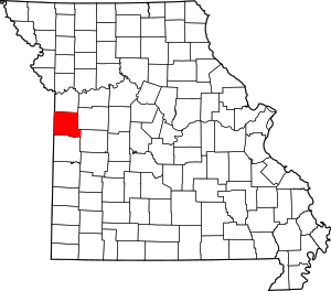 Location within the U.S. state of Missouri | |
 Missouri's location within the U.S. | |
| Coordinates: 38°39′N 94°21′W | |
| Country | |
| State | |
| Founded | March 3, 1835 |
| Named for | Lewis Cass |
| Seat | Harrisonville |
| Largest city | Belton |
| Area | |
| • Total | 702 sq mi (1,820 km2) |
| • Land | 697 sq mi (1,810 km2) |
| • Water | 5.7 sq mi (15 km2) 0.8% |
| Population (2010) | |
| • Total | 99,478 |
| • Estimate (2018) | 104,954 |
| • Density | 140/sq mi (55/km2) |
| Time zone | UTC−6 (Central) |
| • Summer (DST) | UTC−5 (CDT) |
| Congressional district | 4th |
| Website | www |
History
The Harrisonville area was long inhabited by speakers of the Dhegihan Siouan-language family: The Osage, Quapaw, Omaha, Ponca and Kansa tribes make up this sub-group. The Kansa tribal range extended southward from the Kansas-Missouri River junction as far as the northern edge of present-day Bates County, Missouri, taking in the sites of modern Pleasant Hill, Garden City, Archie and Drexel. On their southeastern border they were neighbors of the Osage. There is no evidence that either of these tribes ever had a truly permanent settlement in the territory of Cass County.
Other historical tribes in the area were reportedly Shawnee and Lenape (aka Delaware), whose tribes spoke related Algonquian languages. The Lenape had been pushed to the Midwest from their territory along the mid-Atlantic coast by continuous white encroachment.[5]
In 1818 the United States had granted land to the Lenape in southern Missouri Territory, but they were forced to cede it back in 1825, after Missouri became a state. At that time, they were removed to a reservation in Kansas. Other Lenape had previously migrated south to Texas, seeking refuge in what was still Mexican territory after it gained independence from Spain. Those who remained in the Harrisonville area were close relatives of the Sauk, Fox and Kickapoo tribes.
The early camp meetings held by European-American settlers southwest of Harrisonville often attracted as many as 500 Indians, in addition to Europeans. They seemed the enthusiastic religious services, accompanied by hymn singing and socializing, as much as the white settlers did.[5]
The first European-American settler on the site of modern Harrisonville was James Lackey in 1830. Other early settlers were Humphrey Hunt, John Blythe, and Dr. Joseph Hudspeth. Lackey was considered a "squatter," as he built a cabin and enclosed a small field on the tract of public land taken to establish the county seat.
The site of the town was fixed under an act of the Missouri General Assembly in 1835, by David Waldo of Lafayette County and Samuel Hink and William Brown, both of Jackson County. In the same year, the first court met for the county, known as Van Buren County. Justices James McClellan and William Savage met in McClellan's residence about three miles (5 km) southeast of Peculiar on September 14, 1835. William Lyon was appointed clerk of the court and county government was organized, including the establishment of Grand River Township.
In the spring of 1837 the town of Harrisonville was platted by Enoch Rice, Francis Prine and Welcome Scott, who had been appointed commissioners by the state legislature in the winter of 1836. These commissioners, in company with Martin Rice, the county surveyor, met at the home of John Cook on April 3, 1837 to resolve Lackey's preemption claim. In May they laid off the town in lots 3, 4, 5 and 6 of the northeast and northwest quarters of Section 4, Township 44N., Range 31W. Within these 160 acres (0.65 km2) there were to be four streets: Wall and Pearl running east to west, and Lexington and Independence going north and south, each less than 40 feet wide. Fleming Harris was appointed town commissioner on April 8, 1837. The first town lots were sold on June 12 of that year; those facing the public square sold at $20 each, the others at $10.
"Democrat" was strongly urged as a name for the new town but was finally rejected. The town was named after U.S. Representative Albert G. Harrison from Missouri. The first house within the town was erected by Jason L. Dickey in 1836. The first jail in Harrisonville and second for Cass County was established in 1838. Its site was 312 S. Independence. One of its successors is recognized among the state's historic sites.
On October 8, 1835, the first church in Harrisonville was organized. Its site was two miles southwest of town and it was known as Hopewell or New Hope Baptist.
Harrisonville eventually was served by railroad lines known as the Missouri Pacific and the Frisco. After a scandal in funding railroad construction by the issuance of bonds, three men involved in the swindle were shot and killed by a mob on April 24, 1872, when their train was stopped on a Katy railroad spur. This became known as the "Gunn City Massacre" because it took place near that city.
In 1857 Cass County had approved a large stock subscription for the Pacific Railroad Company, to support its construction in the area. This corporation later surrendered the bonds to the new Saint Louis and Santa Fe Railroad, from whence they were later assigned to the Land Grant Railroad & Construction Company of New York City. Residents of Cass County gained a court injunction in an effort to prevent the funding of these bonds, but by legal maneuvering and collusion, the company gained a new set of bonds, issued secretly.
The populace was outraged, believing this maneuver was intended to benefit the holders of the now worthless bonds, by re-obligating the county to pay those same bonds. The county attorney, a judge of the county court, and a third man involved in the scandal were shot and killed while on a train stopped between Bryson, Missouri and Paola, Kansas. (It was in or near what is now known as Gunn City). Afterward some 41 men were arrested as suspects and prosecuted for these killings, but none was convicted. At the time of the shootings, a related mob burned a Republican newspaper owned by Porter J. Coston, in Harrisonville, Missouri.[6][7]
By 1860, the year before the Civil War, 12 cities in Missouri had populations of approximately 2,500 or more. Harrisonville ranked 37th, with a population of 675. In 1863 the town was depopulated, as the United States forces pushed the people out in an effort to reduce any local support for insurgent guerrilla activity in the area. Most of the buildings were burned, the jail among them. Fort Harrisonville was a Union stronghold for a brief period in 1863 and provided protection for loyal Union families.
Geography
According to the U.S. Census Bureau, the county has a total area of 702 square miles (1,820 km2), of which 697 square miles (1,810 km2) is land and 5.7 square miles (15 km2) (0.8%) is water.[8]
Adjacent counties
- Jackson County (north)
- Johnson County (east)
- Henry County (southeast)
- Bates County (south)
- Miami County, Kansas (west)
- Johnson County, Kansas (northwest)
Major highways
.svg.png)


Demographics
| Historical population | |||
|---|---|---|---|
| Census | Pop. | %± | |
| 1840 | 4,693 | — | |
| 1850 | 6,090 | 29.8% | |
| 1860 | 9,794 | 60.8% | |
| 1870 | 19,296 | 97.0% | |
| 1880 | 22,431 | 16.2% | |
| 1890 | 23,301 | 3.9% | |
| 1900 | 23,636 | 1.4% | |
| 1910 | 22,973 | −2.8% | |
| 1920 | 21,536 | −6.3% | |
| 1930 | 20,962 | −2.7% | |
| 1940 | 19,534 | −6.8% | |
| 1950 | 19,325 | −1.1% | |
| 1960 | 29,702 | 53.7% | |
| 1970 | 39,748 | 33.8% | |
| 1980 | 51,029 | 28.4% | |
| 1990 | 63,808 | 25.0% | |
| 2000 | 82,092 | 28.7% | |
| 2010 | 99,478 | 21.2% | |
| Est. 2018 | 104,954 | [9] | 5.5% |
| U.S. Decennial Census[10] 1790-1960[11] 1900-1990[12] 1990-2000[13] 2010-2015[1] | |||
As of the census[14] of 2000, there were 82,092 people, 30,168 households, and 22,988 families residing in the county. The population density was 117 people per square mile (45/km²). There were 31,677 housing units at an average density of 45 per square mile (18/km²). The racial makeup of the county was 95.62% White, 1.42% Black or African American, 0.58% Native American, 0.48% Asian, 0.04% Pacific Islander, 0.50% from other races, and 1.35% from two or more races. Approximately 2.21% of the population were Hispanic or Latino of any race.
There were 30,168 households out of which 38.10% had children under the age of 18 living with them, 63.60% were married couples living together, 9.10% had a female householder with no husband present, and 23.80% were non-families. 20.00% of all households were made up of individuals and 8.50% had someone living alone who was 65 years of age or older. The average household size was 2.69 and the average family size was 3.09.
In the county, the population was spread out with 28.40% under the age of 18, 7.30% from 18 to 24, 30.20% from 25 to 44, 22.30% from 45 to 64, and 11.70% who were 65 years of age or older. The median age was 36 years. For every 100 females there were 95.90 males. For every 100 females age 18 and over, there were 92.90 males.
The median income for a household in the county was $49,562, and the median income for a family was $55,258. Males had a median income of $39,001 versus $26,174 for females. The per capita income for the county was $21,073. About 4.20% of families and 5.80% of the population were below the poverty line, including 7.00% of those under age 18 and 5.20% of those age 65 or over.
Education
Public schools
- Archie R-V School District – Archie
- Cass County Elementary School (PK-06)
- Archie High School (07-12)
- Belton School District No. 124 – Belton
- Grace Early Childhood Education Center (PK)
- Cambridge Elementary School (K-04)
- Scott Elementary School (K-04)
- Hillcrest Elementary School (K-04)
- Gladden Elementary School (K-04)
- Kentucky Trail Elementary School (K-04)
- Mill Creek Upper Elementary School (05-06)
- Belton Middle School/Freshman Center (07-09)
- Belton High School (10-12)
- Drexel R-IV School District – Drexel
- Drexel Elementary School (K-06)
- Drexel High School (07-12)
- East Lynne School District No. 40 – East Lynne
- East Lynne Elementary School (PK-08)
- Harrisonville R-IX School District – Harrisonville
- Early Childhood Center (PK-K)
- Harrisonville Elementary School (01-05)
- McEowen Elementary School (04-05)
- Harrisonville Middle School (06-08)
- Harrisonville High School (09-12)
- Midway R-I School District – Cleveland
- Midway Elementary School (K-06)
- Midway High School (07-12)
- Pleasant Hill R-III School District – Pleasant Hill
- Pleasant Hill Primary School (PK-02)
- Pleasant Hill Elementary School (03-04)
- Pleasant Hill Intermediate School (05-06)
- Pleasant Hill Middle School (07-08)
- Pleasant Hill High School (09-12)
- Raymore-Peculiar R-II School District – Peculiar
- Raymore Elementary School (K-05)
- Creekmoor Elementary School (K-05)
- Stonegate Elementary School (K-05)
- Timber Creek Elementary School (K-05)
- Peculiar Elementary School (K-05)
- Shull Early Learning Center
- Bridle Ridge Elementary School (K-05)
- Eagle Glen Elementary School (K-05)
- Raymore-Peculiar East Middle School (06-08)
- Raymore-Peculiar South Middle School (06-08)
- Raymore-Peculiar High School (09-12)
- Sherwood Cass R-VIII School District – Creighton
- Sherwood Elementary School (K-05)
- Sherwood Middle School (06-08)
- Sherwood High School (09-12)
- Strasburg C-3 School District – Strasburg
- Strasburg Elementary School (K-08)
Private schools
- Hope Baptist Christian School – Pleasant Hill (01-12) – Baptist
- Harrisonville Christian School – Harrisonville (PK-08) – Nondenominational Christian
- Training Center Christian School – Garden City (PK-12) – Pentecostal
- Heartland High School & Academy – Belton (PK-12) – Baptist
- Blue Ridge Christian School South – Belton (PK-06) – Nondenominational Christian
Public libraries
- Cass County Public Library[15]
Politics
Local
Republicans held twelve of the thirteen elected positions in the county as of the 2014 election.
| Cass County, Missouri | ||||
|---|---|---|---|---|
| Elected countywide officials | ||||
| Assessor | Bob Huston | Republican | ||
| Circuit Clerk | Kim York | Republican | ||
| County Clerk | Michael Vinck | Republican | ||
| Collector | Pam Shipley | Democratic | ||
| Commissioner (Presiding) |
Jeff Cox | Republican | ||
| Commissioner (District 1) |
Monty Kisner | Republican | ||
| Commissioner (District 2) |
Jimmy Odom | Republican | ||
| Prosecuting Attorney | Ben Butler | Republican | ||
| Public Administrator | Melody Folsom | Republican | ||
| Recorder | Mike Medsker | Republican | ||
| Sheriff | Jeff Weber | Republican | ||
| Treasurer | Steve Cheslik | Republican | ||
State
| Year | Republican | Democratic | Third Parties |
|---|---|---|---|
| 2016 | 56.05% 28,571 | 40.64% 20,713 | 3.31% 1,688 |
| 2012 | 49.19% 23,837 | 47.81% 23,168 | 3.00% 1,454 |
| 2008 | 45.77% 22,592 | 52.18% 25,754 | 2.05% 1,010 |
| 2004 | 53.53% 23,538 | 44.97% 19,772 | 1.49% 659 |
| 2000 | 52.74% 18,777 | 45.18% 16,084 | 2.08% 742 |
| 1996 | 38.32% 11,038 | 59.21% 17,055 | 2.47% 710 |
Cass County is divided into five legislative districts in the Missouri House of Representatives, four of which are held by Republicans and one by a Democrat.
- District 33 – Donna Pfautsch (R-Harrisonville). Consists of the communities of East Lynne, Gunn City, Harrisonville, Pleasant Hill, and Strasburg.
| Party | Candidate | Votes | % | ± | |
|---|---|---|---|---|---|
| Republican | Donna Pfautsch | 7,211 | 70.06% | -1.52 | |
| Democratic | Chase Linder | 3,082 | 29.94% | +15.33 | |
| Party | Candidate | Votes | % | ± | |
|---|---|---|---|---|---|
| Republican | Donna Pfautsch | 3,767 | 71.58% | +8.43 | |
| Democratic | Syed Asif | 769 | 14.61% | -22.24 | |
| Libertarian | Matthew Stephens | 727 | 13.81% | +13.81 | |
| Party | Candidate | Votes | % | ± | |
|---|---|---|---|---|---|
| Republican | Donna Pfautsch | 5,838 | 63.15% | ||
| Democratic | Ron Harvey | 3,407 | 36.85% | ||
- District 37 — Joe Runions (D-Grandview). Consists of parts of the cities of Lake Winnebago and Raymore.
| Party | Candidate | Votes | % | ± | |
|---|---|---|---|---|---|
| Democratic | Joe Runions | 1,601 | 100.00% | ||
| Party | Candidate | Votes | % | ± | |
|---|---|---|---|---|---|
| Democratic | Joe Runions | 748 | 100.00% | +59.05 | |
| Party | Candidate | Votes | % | ± | |
|---|---|---|---|---|---|
| Democratic | Joe Runions | 819 | 40.95% | ||
| Republican | Nola Wood | 1,181 | 59.05% | ||
- District 55 – Rick Brattin (R-Harrisonville). Consists of the communities of Garden City, Peculiar, and parts of Lake Winnebago and Raymore.
| Party | Candidate | Votes | % | ± | |
|---|---|---|---|---|---|
| Republican | Rick Brattin | 12,350 | 63.37% | -36.63 | |
| Democratic | Ashley Beard-Fosnow | 7,139 | 36.63% | +36.63 | |
| Party | Candidate | Votes | % | ± | |
|---|---|---|---|---|---|
| Republican | Rick Brattin | 8,362 | 100.00% | +35.50 | |
| Party | Candidate | Votes | % | ± | |
|---|---|---|---|---|---|
| Republican | Rick Brattin | 11,747 | 64.50% | ||
| Democratic | Jim White | 6,465 | 35.50% | ||
- District 56 — Dan Bonden (R-Belton). Consists of the communities of Belton, Cleveland, Drexel, Freeman, Lake Annette, and a tiny sliver of Kansas City.
| Party | Candidate | Votes | % | ± | |
|---|---|---|---|---|---|
| Republican | Jack Bondon | 10,764 | 68.60% | +2.31 | |
| Democratic | DJ Rash | 4,927 | 31.40% | -2.31 | |
| Party | Candidate | Votes | % | ± | |
|---|---|---|---|---|---|
| Republican | Jack Bondon | 5,259 | 66.29% | +1.15 | |
| Democratic | Patty Johnson | 2,674 | 33.71% | -1.15 | |
| Party | Candidate | Votes | % | ± | |
|---|---|---|---|---|---|
| Republican | Chris Molendrop | 9,776 | 65.14% | ||
| Democratic | Patty Johnson | 5,231 | 34.86% | ||
- District 57 — Wanda Brown (R-Lincoln). Consists of the communities of Archie and Creighton.
| Party | Candidate | Votes | % | ± | |
|---|---|---|---|---|---|
| Republican | Wanda Brown | 1,291 | 66.31% | +10.87 | |
| Democratic | William A. Grimes | 656 | 33.69% | +2.50 | |
| Party | Candidate | Votes | % | ± | |
|---|---|---|---|---|---|
| Republican | Wanda Brown | 622 | 55.44% | -6.04 | |
| Democratic | William A. Grimes | 350 | 31.19% | -7.33 | |
| Constitution | Butch Page | 150 | 13.37% | +13.37 | |
| Party | Candidate | Votes | % | ± | |
|---|---|---|---|---|---|
| Republican | Wanda Brown | 1,114 | 61.48% | ||
| Democratic | Don Bullock | 698 | 38.52% | ||
All of Cass County is a part of Missouri's 31st District in the Missouri Senate and is currently represented by Ed Emery (R-Lamar).
| Party | Candidate | Votes | % | ± | |
|---|---|---|---|---|---|
| Republican | Ed Emery | 34,934 | 72.71% | +9.68 | |
| Libertarian | Lora Young | 7,168 | 14.92% | +14.92 | |
| Independent | Tim Wells | 5,944 | 12.37% | +12.37 | |
| Party | Candidate | Votes | % | ± | |
|---|---|---|---|---|---|
| Republican | Ed Emery | 29,721 | 63.03% | ||
| Democratic | Charles A. Burton | 17,432 | 36.97% | ||
Federal
| Party | Candidate | Votes | % | ± | |
|---|---|---|---|---|---|
| Republican | Roy Blunt | 27,532 | 54.12% | +9.55 | |
| Democratic | Jason Kander | 20,628 | 40.55% | -6.24 | |
| Libertarian | Jonathan Dine | 1,542 | 3.03% | -5.61 | |
| Green | Johnathan McFarland | 594 | 1.17% | +1.17 | |
| Constitution | Fred Ryman | 578 | 1.14% | +1.14 | |
| Party | Candidate | Votes | % | ± | |
|---|---|---|---|---|---|
| Republican | Todd Akin | 21,557 | 44.57% | ||
| Democratic | Claire McCaskill | 22,626 | 46.79% | ||
| Libertarian | Jonathan Dine | 4,179 | 8.64% | ||
Cass County is included in Missouri's 4th Congressional District and is currently represented by Vicky Hartzler (R-Harrisonville) in the U.S. House of Representatives.
| Party | Candidate | Votes | % | ± | |
|---|---|---|---|---|---|
| Republican | Vicky Hartzler | 34,998 | 69.61% | -0.01 | |
| Democratic | Gordon Christensen | 13,198 | 26.25% | +1.33 | |
| Libertarian | Mark Bliss | 2,082 | 4.14% | -1.32 | |
| Party | Candidate | Votes | % | ± | |
|---|---|---|---|---|---|
| Republican | Vicky Hartzler | 17,869 | 69.62% | +13.27 | |
| Democratic | Nate Irvin | 6,396 | 24.92% | -15.54 | |
| Libertarian | Herschel L. Young | 1,400 | 5.46% | +2.99 | |
| Party | Candidate | Votes | % | ± | |
|---|---|---|---|---|---|
| Republican | Vicky Hartzler | 27,169 | 56.35% | ||
| Democratic | Teresa Hensley | 19,505 | 40.46% | ||
| Libertarian | Thomas Holbrook | 1,192 | 2.47% | ||
| Constitution | Greg Cowan | 348 | 0.72% | ||
Presidential preference
Cass County was up to World War II solidly Democratic as it had strong secessionist sympathies. However, since 1952 it has become a strongly Republican county in presidential elections. The last time a Democratic candidate won the county was in 1976 by Jimmy Carter, but incumbent President George Bush senior only won in the county by a margin of 0.3 percentage point in 1992.
| Year | Republican | Democratic | Third parties |
|---|---|---|---|
| 2016 | 64.4% 33,098 | 28.9% 14,846 | 6.7% 3,466 |
| 2012 | 63.0% 30,912 | 34.7% 17,044 | 2.3% 1,148 |
| 2008 | 59.0% 29,695 | 39.4% 19,844 | 1.6% 802 |
| 2004 | 61.6% 27,253 | 37.7% 16,681 | 0.6% 283 |
| 2000 | 56.1% 20,113 | 41.6% 14,921 | 2.3% 835 |
| 1996 | 46.5% 13,495 | 40.5% 11,743 | 13.0% 3,772 |
| 1992 | 34.6% 10,349 | 34.3% 10,246 | 31.1% 9,310 |
| 1988 | 55.8% 12,799 | 44.0% 10,092 | 0.3% 67 |
| 1984 | 65.8% 14,456 | 34.2% 7,517 | |
| 1980 | 52.8% 10,105 | 42.9% 8,198 | 4.4% 831 |
| 1976 | 44.0% 7,182 | 55.2% 9,008 | 0.9% 140 |
| 1972 | 71.2% 9,242 | 28.8% 3,731 | |
| 1968 | 45.1% 5,271 | 38.3% 4,468 | 16.6% 1,938 |
| 1964 | 35.5% 3,665 | 64.5% 6,658 | |
| 1960 | 53.3% 6,523 | 46.7% 5,718 | |
| 1956 | 50.1% 5,589 | 49.9% 5,575 | |
| 1952 | 54.0% 6,000 | 45.8% 5,089 | 0.1% 13 |
| 1948 | 40.0% 3,614 | 59.9% 5,415 | 0.2% 16 |
| 1944 | 51.8% 4,687 | 48.1% 4,347 | 0.1% 7 |
| 1940 | 47.6% 4,983 | 52.3% 5,479 | 0.2% 17 |
| 1936 | 41.3% 4,070 | 58.2% 5,731 | 0.5% 52 |
| 1932 | 34.0% 3,009 | 65.2% 5,772 | 0.8% 66 |
| 1928 | 59.1% 5,299 | 40.7% 3,647 | 0.2% 18 |
| 1924 | 42.2% 3,610 | 55.0% 4,709 | 2.8% 242 |
| 1920 | 44.2% 4,055 | 54.8% 5,030 | 1.1% 100 |
| 1916 | 38.0% 2,104 | 60.2% 3,337 | 1.9% 103 |
| 1912 | 18.4% 1,034 | 57.7% 3,247 | 23.9% 1,346 |
| 1908 | 39.8% 2,193 | 57.1% 3,143 | 3.1% 168 |
| 1904 | 44.4% 2,375 | 51.4% 2,750 | 4.3% 229 |
| 1900 | 37.9% 2,162 | 58.7% 3,350 | 3.5% 200 |
| 1896 | 35.5% 2,229 | 63.3% 3,975 | 1.2% 75 |
| 1892 | 35.2% 1,908 | 55.9% 3,027 | 8.9% 481 |
| 1888 | 40.0% 2,095 | 57.6% 3,015 | 2.4% 124 |
Missouri presidential preference primary (2008)
- Former U.S. Senator Hillary Clinton (D-New York) received more votes, a total of 6,500, than any candidate from either party in Cass County during the 2008 presidential primary.
| Cass County, Missouri | |
|---|---|
| 2008 Republican primary in Missouri | |
| John McCain | 3,195 (31.28%) |
| Mike Huckabee | 3,033 (29.70%) |
| Mitt Romney | 3,324 (32.55%) |
| Ron Paul | 477 (4.67%) |
| Cass County, Missouri | |
|---|---|
| 2008 Democratic primary in Missouri | |
| Hillary Clinton | 6,500 (59.76%) |
| Barack Obama | 3,995 (36.73%) |
| John Edwards (withdrawn) | 302 (2.78%) |
Communities
Cities
- Archie
- Belton
- Cleveland
- Creighton
- Drexel
- East Lynne
- Freeman
- Garden City
- Harrisonville (county seat)
- Kansas City (mostly in Jackson, Platte and Clay Counties)
- Lake Annette
- Lake Winnebago
- Lee's Summit
- Peculiar
- Pleasant Hill
- Raymore
- Strasburg
Villages
Census-designated places
Unincorporated Communities
See also
References
- "State & County QuickFacts". United States Census Bureau. Retrieved September 7, 2013.
- "Find a County". National Association of Counties. Archived from the original on 2011-05-31. Retrieved 2011-06-07.
- Eaton, David Wolfe (1916). How Missouri Counties, Towns and Streams Were Named. The State Historical Society of Missouri. pp. 272.
- "Disappearing Missouri Names". The Kansas City Star. March 19, 1911. p. 15. Archived from the original on August 19, 2014. Retrieved August 15, 2014 – via Newspapers.com.
- The History of Cass and Bates Counties, Missouri. National Historical Company, Saint Joseph, Missouri. 1883. p. 272. Retrieved February 26, 2016.
- Harrison, E.S. Nome and Seward: History, Biography, Descriptions, and Stories. Internet Archive. p. 337.
Gunn City Massacre
- O'Flaherty, Daniel C. (1954). General Jo Shelby: Undefeated Rebel. University of North Carolina Press. ISBN 0-8078-4878-6.
republished 2000
- "2010 Census Gazetteer Files". United States Census Bureau. August 22, 2012. Archived from the original on October 21, 2013. Retrieved November 14, 2014.
- "Population and Housing Unit Estimates". Retrieved November 29, 2019.
- "U.S. Decennial Census". United States Census Bureau. Retrieved November 14, 2014.
- "Historical Census Browser". University of Virginia Library. Retrieved November 14, 2014.
- "Population of Counties by Decennial Census: 1900 to 1990". United States Census Bureau. Retrieved November 14, 2014.
- "Census 2000 PHC-T-4. Ranking Tables for Counties: 1990 and 2000" (PDF). United States Census Bureau. Retrieved November 14, 2014.
- "U.S. Census website". United States Census Bureau. Retrieved 2011-05-14.
- Breeding, Marshall. "Cass County Public Library". Libraries.org. Retrieved May 8, 2017.
- Leip, David. "Dave Leip's Atlas of U.S. Presidential Elections". uselectionatlas.org. Retrieved 2018-03-24.
Further reading
- Glenn, Allen. History of Cass County, Missouri (1917) online
External links
- Cass County government link's website
- Digitized 1930 Plat Book of Cass County from University of Missouri Division of Special Collections, Archives, and Rare Books
Places adjacent to Cass County, Missouri | ||||||||||
|---|---|---|---|---|---|---|---|---|---|---|
| ||||||||||
Kansas City metropolitan area's cities and counties | ||
|---|---|---|
| Central city | 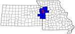 | |
| Largest cities (over 100,000 in 2000) | ||
| Medium-sized cities (10,000 to 100,000 in 2000) | ||
| Smaller Cities (between 5,000 and 9,900 in 2010) | ||
| Counties | ||
Municipalities and communities of Cass County, Missouri, United States | ||
|---|---|---|
| Cities | Map of Missouri highlighting Cass County | |
| Villages | ||
| Townships | ||
| Unincorporated communities | ||
| Ghost towns | ||
| Footnotes | ‡This populated place also has portions in an adjacent county or counties | |

| Authority control |
|
|---|