Polk County, Missouri
Polk County is a county located in the southwestern portion of the U.S. state of Missouri. As of the 2010 census, the population was 31,137.[1] Its county seat is Bolivar.[2] The county was founded January 5, 1835, and named for Ezekiel Polk.
Polk County | |
|---|---|
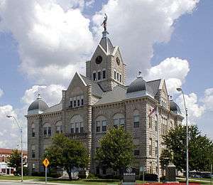 Polk County Courthouse in Bolivar | |
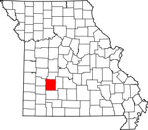 Location within the U.S. state of Missouri | |
 Missouri's location within the U.S. | |
| Coordinates: 37°37′N 93°24′W | |
| Country | |
| State | |
| Founded | January 5, 1835 |
| Named for | James K. Polk |
| Seat | Bolivar |
| Largest city | Bolivar |
| Area | |
| • Total | 642 sq mi (1,660 km2) |
| • Land | 636 sq mi (1,650 km2) |
| • Water | 6.9 sq mi (18 km2) 1.1% |
| Population (2010) | |
| • Total | 31,137 |
| • Estimate (2018) | 32,201 |
| • Density | 49/sq mi (19/km2) |
| Time zone | UTC−6 (Central) |
| • Summer (DST) | UTC−5 (CDT) |
| Congressional district | 7th |
Polk County is part of the Springfield, MO Metropolitan Statistical Area.
History
Polk County was organized and separated from Greene County on January 5, 1835. Its original boundaries were later reduced in creating Dade, Dallas, and Hickory counties. It was named in honor of former US President James K. Polk.
Geography
According to the U.S. Census Bureau, the county has a total area of 642 square miles (1,660 km2), of which 636 square miles (1,650 km2) is land and 6.9 square miles (18 km2) (1.1%) is water.[3]
Adjacent counties
- Hickory County (north)
- Dallas County (east)
- Greene County (south)
- Dade County (southwest)
- Cedar County (west)
- St. Clair County (northwest)
Demographics
| Historical population | |||
|---|---|---|---|
| Census | Pop. | %± | |
| 1840 | 8,449 | — | |
| 1850 | 6,186 | −26.8% | |
| 1860 | 9,995 | 61.6% | |
| 1870 | 12,445 | 24.5% | |
| 1880 | 15,734 | 26.4% | |
| 1890 | 20,339 | 29.3% | |
| 1900 | 23,255 | 14.3% | |
| 1910 | 21,561 | −7.3% | |
| 1920 | 20,351 | −5.6% | |
| 1930 | 17,803 | −12.5% | |
| 1940 | 17,400 | −2.3% | |
| 1950 | 16,062 | −7.7% | |
| 1960 | 13,753 | −14.4% | |
| 1970 | 15,415 | 12.1% | |
| 1980 | 18,822 | 22.1% | |
| 1990 | 21,826 | 16.0% | |
| 2000 | 26,992 | 23.7% | |
| 2010 | 31,137 | 15.4% | |
| Est. 2018 | 32,201 | [4] | 3.4% |
| U.S. Decennial Census[5] 1790-1960[6] 1900-1990[7] 1990-2000[8] 2010-2015[1] | |||
As of the census[9] of 2000, there were 26,992 people, 9,917 households, and 7,140 families residing in the county. The population density was 42 people per square mile (16/km²). There were 11,183 housing units at an average density of 18 per square mile (7/km²). The racial makeup of the county was 97.26% White, 0.45% Black or African American, 0.67% Native American, 0.19% Asian, 0.03% Pacific Islander, 0.33% from other races, and 1.06% from two or more races. Approximately 1.30% of the population were Hispanic or Latino of any race.
There were 9,917 households out of which 33.00% had children under the age of 18 living with them, 60.50% were married couples living together, 8.20% had a female householder with no husband present, and 28.00% were non-families. 23.20% of all households were made up of individuals and 10.70% had someone living alone who was 65 years of age or older. The average household size was 2.56 and the average family size was 3.02.
In the county, the population was spread out with 25.70% under the age of 18, 12.60% from 18 to 24, 25.50% from 25 to 44, 20.80% from 45 to 64, and 15.30% who were 65 years of age or older. The median age was 35 years. For every 100 females, there were 94.90 males. For every 100 females age 18 and over, there were 90.90 males.
The median income for a household in the county was $29,656, and the median income for a family was $35,843. Males had a median income of $25,383 versus $18,799 for females. The per capita income for the county was $13,645. About 11.10% of families and 16.30% of the population were below the poverty line, including 20.00% of those under age 18 and 12.00% of those age 65 or over.
Education
Public libraries
- Polk County Public Library[10]
Politics
Local
The Republican Party completely controls politics at the local level in Polk County. Republicans hold all of the elected positions in the county.
| Polk County, Missouri | ||||
|---|---|---|---|---|
| Elected countywide officials | ||||
| Assessor | Carolyn Page | Republican | ||
| Circuit Clerk | Tiffany Phillips | Republican | ||
| County Clerk | Melinda Robertson | Republican | ||
| Collector | Debbi R-McGinnis | Republican | ||
| Commissioner (Presiding) |
Shannon Hancock | Republican | ||
| Commissioner (District 1) |
Kyle Legan | Republican | ||
| Commissioner (District 2) |
Rex Austin | Republican | ||
| Coroner | Melissa Britton | Republican | ||
| Prosecuting Attorney | Kenneth R. Ashlock | Republican | ||
| Public Administrator | Barbara Davolt | Republican | ||
| Recorder | Carol Poindexter | Republican | ||
| Sheriff | Danny Morrison | Republican | ||
| Surveyor | Mike Shuler | Republican | ||
| Treasurer | Vonna Bauer | Republican | ||
State
| Year | Republican | Democratic | Third Parties |
|---|---|---|---|
| 2016 | 66.92% 9,251 | 30.15% 4,168 | 2.92% 404 |
| 2012 | 53.89% 7,052 | 43.15% 5,647 | 2.96% 388 |
| 2008 | 45.76% 6,244 | 49.52% 6,758 | 4.72% 644 |
| 2004 | 67.84% 8,418 | 30.90% 3,835 | 1.56% 1.26 |
| 2000 | 58.65% 5,996 | 39.79% 4,068 | 1.55% 159 |
| 1996 | 55.64% 5,043 | 40.51% 3,672 | 3.85% 349 |
All of Polk County is in the 128th district in the Missouri House of Representatives, and is represented by Mike Stephens (R-Bolivar).
| Party | Candidate | Votes | % | ± | |
|---|---|---|---|---|---|
| Republican | Mike Stephens | 11,500 | 85.48% | -14.52 | |
| Independent | Janet Sheffield | 1,953 | 14.52% | +14.52 | |
| Party | Candidate | Votes | % | ± | |
|---|---|---|---|---|---|
| Republican | Sue Entichler | 5,903 | 100.00% | ||
| Party | Candidate | Votes | % | ± | |
|---|---|---|---|---|---|
| Republican | Sue Entlicher | 11,744 | 100.00% | ||
All of Polk County is a part of Missouri’s 28th District in the Missouri Senate, which is currently vacant. The previous incumbent, Mike Parson, was elected Missouri Lieutenant Governor in November 2016.
| Party | Candidate | Votes | % | ± | |
|---|---|---|---|---|---|
| Republican | Mike Parson | 5,832 | 100.00% | ||
Federal
| Party | Candidate | Votes | % | ± | |
|---|---|---|---|---|---|
| Republican | Roy Blunt | 9,693 | 69.93% | +17.50 | |
| Democratic | Jason Kander | 3,605 | 26.01% | -14.35 | |
| Libertarian | Jonathan Dine | 327 | 2.36% | -4.85 | |
| Green | Johnathan McFarland | 107 | 0.77% | +0.77 | |
| Constitution | Fred Ryman | 129 | 0.93% | +0.93 | |
| Party | Candidate | Votes | % | ± | |
|---|---|---|---|---|---|
| Republican | Todd Akin | 6,789 | 52.43% | ||
| Democratic | Claire McCaskill | 5,226 | 40.36% | ||
| Libertarian | Jonathan Dine | 933 | 7.21% | ||
All of Polk county is included in Missouri’s 7th Congressional District and is currently represented by Billy Long (R-Springfield) in the U.S. House of Representatives.
| Party | Candidate | Votes | % | ± | |
|---|---|---|---|---|---|
| Republican | Billy Long | 10,170 | 74.34% | +6.06 | |
| Democratic | Genevieve Williams | 2,880 | 21.05% | -2.42 | |
| Libertarian | Benjamin T. Brixey | 630 | 4.61% | -3.64 | |
| Party | Candidate | Votes | % | ± | |
|---|---|---|---|---|---|
| Republican | Billy Long | 4,442 | 68.28% | +1.25 | |
| Democratic | Jim Evans | 1,527 | 23.47% | -4.21 | |
| Libertarian | Kevin Craig | 537 | 8.25% | +2.95 | |
| Party | Candidate | Votes | % | ± | |
|---|---|---|---|---|---|
| Republican | Billy Long | 8,631 | 67.03% | ||
| Democratic | Jim Evans | 3,564 | 27.68% | ||
| Libertarian | Kevin Craig | 682 | 5.30% | ||
Political culture
Polk County has been a Republican Party stronghold for most of its history at the presidential level. In only four presidential elections from 1896 to the present has a Democratic Party candidate carried the county, the most recent being Lyndon B. Johnson in 1964.
| Year | Republican | Democratic | Third parties |
|---|---|---|---|
| 2016 | 75.8% 10,438 | 19.1% 2,631 | 5.0% 694 |
| 2012 | 70.5% 9,252 | 27.3% 3,580 | 2.2% 287 |
| 2008 | 65.4% 8,956 | 33.2% 4,553 | 1.4% 188 |
| 2004 | 69.0% 8,586 | 30.3% 3,775 | 0.7% 92 |
| 2000 | 62.5% 6,430 | 35.0% 3,606 | 2.5% 258 |
| 1996 | 49.7% 4,521 | 36.4% 3,307 | 13.9% 1,261 |
| 1992 | 39.9% 3,465 | 38.2% 3,316 | 21.8% 1,894 |
| 1988 | 59.4% 5,030 | 40.4% 3,419 | 0.3% 21 |
| 1984 | 66.0% 5,467 | 34.0% 2,819 | |
| 1980 | 57.9% 4,842 | 39.9% 3,336 | 2.3% 190 |
| 1976 | 51.3% 3,893 | 48.3% 3,663 | 0.5% 34 |
| 1972 | 70.7% 5,409 | 29.3% 2,245 | |
| 1968 | 59.8% 4,145 | 31.3% 2,170 | 8.9% 614 |
| 1964 | 49.5% 3,288 | 50.5% 3,353 | |
| 1960 | 66.5% 4,849 | 33.5% 2,440 | |
| 1956 | 59.8% 4,410 | 40.2% 2,968 | |
| 1952 | 67.8% 5,263 | 31.9% 2,474 | 0.3% 24 |
| 1948 | 56.7% 4,026 | 43.3% 3,079 | 0.0% 2 |
| 1944 | 66.5% 5,040 | 33.3% 2,527 | 0.2% 18 |
| 1940 | 62.0% 5,534 | 37.9% 3,380 | 0.2% 14 |
| 1936 | 56.7% 5,126 | 43.1% 3,899 | 0.3% 23 |
| 1932 | 46.4% 3,811 | 53.0% 4,355 | 0.6% 47 |
| 1928 | 69.6% 5,307 | 30.2% 2,303 | 0.2% 12 |
| 1924 | 56.2% 4,097 | 41.6% 3,033 | 2.2% 161 |
| 1920 | 62.8% 4,967 | 36.0% 2,847 | 1.2% 93 |
| 1916 | 53.8% 2,613 | 44.2% 2,149 | 2.0% 96 |
| 1912 | 39.0% 1,802 | 41.9% 1,935 | 19.0% 879 |
| 1908 | 54.4% 2,670 | 43.6% 2,139 | 2.0% 96 |
| 1904 | 56.9% 2,659 | 38.7% 1,807 | 4.5% 209 |
| 1900 | 53.6% 2,679 | 43.6% 2,178 | 2.8% 142 |
| 1896 | 48.3% 2,564 | 51.1% 2,711 | 0.6% 31 |
| 1892 | 46.0% 1,918 | 29.0% 1,211 | 25.0% 1,042 |
| 1888 | 49.0% 2,100 | 41.8% 1,794 | 9.2% 394 |
Missouri presidential preference primary (2008)
| Polk County, Missouri | |
|---|---|
| 2008 Republican primary in Missouri | |
| John McCain | 1,141 (25.28%) |
| Mike Huckabee | 2,317 (51.33%) |
| Mitt Romney | 842 (18.65%) |
| Ron Paul | 154 (3.41%) |
| Polk County, Missouri | |
|---|---|
| 2008 Democratic primary in Missouri | |
| Hillary Clinton | 1,904 (63.81%) |
| Barack Obama | 993 (33.28%) |
| John Edwards (withdrawn) | 67 (2.25%) |
Former Governor Mike Huckabee (R-Arkansas) received more votes, a total of 2,317, than any candidate from either party in Polk County during the 2008 presidential primary.
Media
The Bolivar Herald-Free Press is published twice weekly.
Communities
Cities
- Bolivar (county seat)
- Fair Play
- Humansville
- Morrisville
- Pleasant Hope
Villages
Unincorporated communities
Townships
Polk County is divided into 22 townships:
- Campbell Township
- Cliquot Township
- East Looney Township
- East Madison Township
- Flemington Township
- Jackson Township
- Jefferson Township
- Johnson Township
- McKinley Township
- Mooney Township
- North Benton Township
- North Green Township
- Northeast Marion Township
- Northwest Marion Township
- South Benton Township
- South Green Township
- Southeast Marion Township
- Southwest Marion Township
- Union Township
- West Looney Township
- West Madison Township
- Wishart Township
See also
- National Register of Historic Places listings in Polk County, Missouri
References
- "State & County QuickFacts". United States Census Bureau. Archived from the original on July 17, 2011. Retrieved September 12, 2013.
- "Find a County". National Association of Counties. Retrieved 2011-06-07.
- "2010 Census Gazetteer Files". United States Census Bureau. August 22, 2012. Archived from the original on October 21, 2013. Retrieved November 18, 2014.
- "Population and Housing Unit Estimates". Retrieved November 13, 2019.
- "U.S. Decennial Census". United States Census Bureau. Retrieved November 18, 2014.
- "Historical Census Browser". University of Virginia Library. Retrieved November 18, 2014.
- "Population of Counties by Decennial Census: 1900 to 1990". United States Census Bureau. Retrieved November 18, 2014.
- "Census 2000 PHC-T-4. Ranking Tables for Counties: 1990 and 2000" (PDF). United States Census Bureau. Retrieved November 18, 2014.
- "U.S. Census website". United States Census Bureau. Retrieved 2008-01-31.
- Breeding, Marshall. "Polk County Public Library". Libraries.org. Retrieved May 8, 2017.
- Leip, David. "Dave Leip's Atlas of U.S. Presidential Elections". uselectionatlas.org. Retrieved 2018-03-26.
External links
- http://www.bolivarmonews.com/
- Digitized 1930 Plat Book of Polk County from University of Missouri Division of Special Collections, Archives, and Rare Books
- Polk County Sheriff's Office
Places adjacent to Polk County, Missouri | ||||||||||
|---|---|---|---|---|---|---|---|---|---|---|
| ||||||||||
Municipalities and communities of Polk County, Missouri, United States | ||
|---|---|---|
| Cities | Map of Missouri highlighting Polk County | |
| Villages | ||
| Townships | ||
| Unincorporated communities | ||
| Ghost towns | ||
