Caldwell County, Missouri
Caldwell County is a county located in Missouri, United States. As of the 2010 census, the county's population was 9,424. It is part of the Kansas City metropolitan area.[1] Its county seat is Kingston.[2] The county was organized December 29, 1836 and named by Alexander Doniphan to honor John Caldwell, who participated in George Rogers Clark's Native American Campaign of 1786 and was the second Lieutenant Governor of Kentucky.
Caldwell County | |
|---|---|
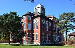 Caldwell County courthouse in Kingston | |
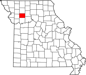 Location within the U.S. state of Missouri | |
 Missouri's location within the U.S. | |
| Coordinates: 39°40′N 93°59′W | |
| Country | |
| State | |
| Founded | December 29, 1836 |
| Named for | John Caldwell |
| Seat | Kingston |
| Largest city | Hamilton |
| Area | |
| • Total | 430 sq mi (1,100 km2) |
| • Land | 426 sq mi (1,100 km2) |
| • Water | 3.2 sq mi (8 km2) 0.8% |
| Population (2010) | |
| • Total | 9,424 |
| • Estimate (2018) | 9,108 |
| • Density | 22/sq mi (8.5/km2) |
| Time zone | UTC−6 (Central) |
| • Summer (DST) | UTC−5 (CDT) |
| Congressional district | 6th |
| Website | www |
Caldwell County was originally established as a haven for Mormons, who had been driven from Jackson County in November 1833 and had been refugees in adjacent Clay County since. The county was one of the principal settings of the 1838 Missouri Mormon War, which led to the expulsion of all Latter Day Saints from Missouri, following the issuance of an "extermination order" by then–Governor Lilburn Boggs.
History
Mormon settlement
Caldwell County was originally part of Ray County. The first white settler was Jesse Mann, Sr., who settled one-half mile northeast of the public square of Kingston on Shoal Creek in 1831. The early settlers moved back south in 1832 for better protection during the Black Hawk War uprising.
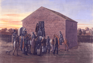
A few Mormon settlers, who had been evicted from Jackson County, Missouri, moved into the county in 1832, and included Jacob Haun, whose mill on Shoal Creek would become the scene of the bloodiest incident in the Mormon War, known as the Haun's Mill Massacre.
The settlers established Salem, the first town in the county, two miles southeast of Kingston. A larger number of Mormons moved to the county in the fall of 1836. The Missouri General Assembly created Caldwell County in December 1836, with the understanding that it would be dedicated to Mormon settlers. Its county seat was Far West, Missouri. By 1838 Far West reported a population of 4,000.[3]
The major figures of early Mormon history, including Joseph Smith, Hyrum Smith, Brigham Young, John Taylor, Edward Partridge, Sidney Rigdon, Parley P. Pratt and John D. Lee, were included in the migration.
Mormon War
Mormon settlers moved further north into Daviess County, particularly at Adam-ondi-Ahman after Smith proclaimed that it was the Biblical place where Adam and Eve were banished after leaving the Garden of Eden. He said it would be a gathering place on the Judgement Day. The Mormon War erupted following a skirmish between original Missouri settlers and Mormon settlers in the Gallatin Election Day Battle.
After the Missouri militia was routed in the Battle of Crooked Creek, Governor Lilburn Boggs issued Missouri Executive Order 44 to evict the Mormons from the state. Three days later, a group from Livingston County killed 18 Mormons in the Haun's Mill massacre. Troops laid siege to Far West, where Smith surrendered in October 1838. The settlers agreed to leave; they abandoned Far West and regrouped in Nauvoo, Illinois.
Following the dissolution of Far West, the county seat was moved to present-day Kingston.
Geography
According to the U.S. Census Bureau, the county has a total area of 430 square miles (1,100 km2), of which 426 square miles (1,100 km2) is land and 3.2 square miles (8.3 km2) (0.8%) is water.[4]
Adjacent counties
- Daviess County (north)
- Livingston County (east)
- Carroll County (southeast)
- Ray County (south)
- Clinton County (west)
- DeKalb County (northwest)
Demographics
| Historical population | |||
|---|---|---|---|
| Census | Pop. | %± | |
| 1840 | 1,458 | — | |
| 1850 | 2,310 | 58.4% | |
| 1860 | 5,034 | 117.9% | |
| 1870 | 11,390 | 126.3% | |
| 1880 | 13,646 | 19.8% | |
| 1890 | 15,152 | 11.0% | |
| 1900 | 16,656 | 9.9% | |
| 1910 | 14,605 | −12.3% | |
| 1920 | 13,849 | −5.2% | |
| 1930 | 12,509 | −9.7% | |
| 1940 | 11,629 | −7.0% | |
| 1950 | 9,929 | −14.6% | |
| 1960 | 8,830 | −11.1% | |
| 1970 | 8,351 | −5.4% | |
| 1980 | 8,660 | 3.7% | |
| 1990 | 8,380 | −3.2% | |
| 2000 | 8,969 | 7.0% | |
| 2010 | 9,424 | 5.1% | |
| Est. 2018 | 9,108 | [6] | −3.4% |
| U.S. Decennial Census[7] 1790-1960[8] 1900-1990[9] 1990-2000[10] 2010-2015[1] | |||
As of the census[11] of 2000, there were 8,969 people, 3,523 households, and 2,501 families residing in the county. The population density was 8/km² (21/mi²). There were 4,493 housing units at an average density of 4/km² (10/mi²). The racial makeup of the county was 98.56% White, 0.13% Black or African American, 0.33% Native American, 0.12% Asian, 0.00% Pacific Islander, 0.18% from other races, and 0.67% from two or more races. 0.75% of the population were Hispanic or Latino of any race.
There were 3,523 households out of which 32.30% had children under the age of 18 living with them, 59.20% were married couples living together, 8.00% had a female householder with no husband present, and 29.00% were non-families. 25.50% of all households were made up of individuals and 13.00% had someone living alone who was 65 years of age or older. The average household size was 2.51, and the average family size was 3.04.
In the county, the population was spread out with 27.10% under the age of 18, 7.10% from 18 to 24, 25.10% from 25 to 44, 23.70% from 45 to 64, and 17.00% who were 65 years of age or older. The median age was 39 years. For every 100 females there were 97.60 males. For every 100 females age 18 and over, there were 93.90 males.
The median income for a household in the county was $31,240, and the median income for a family was $37,087. Males had a median income of $28,710 versus $19,523 for females. The per capita income for the county was $15,343. 11.90% of the population and 9.70% of families were below the poverty line. Out of the total population, 15.10% of those under the age of 18 and 12.90% of those 65 and older were living below the poverty line.
Education
Public Schools
- Braymer C-4 School District – Braymer
- Braymer Elementary School (PK-06)
- Braymer High School (07-12)
- Breckenridge R-I School District – Breckenridge
- Breckinridge Elementary School (PK-06)
- Breckinridge High School (07-12)
- Cowgill R-VI School District – Cowgill
- Cowgill Elementary School (K-06)
- Kingston School District No. 42 – Kingston
- Kingston Elementary School (PK-08)
- Mirabile C-1 School District – Polo
- Mirabile Elementary School (PK-08)
- New York R-IV School District – Hamilton
- New York Elementary School (K-08)
- Polo R-VII School District – Polo
- Polo Elementary School (PK-04)
- Polo Middle School (05-08)
- Polo High School (09-12)
Politics
Local
The Republican Party controls politics at the local level in Caldwell County. Republicans hold all but three of the elected positions in the county.
| Caldwell County, Missouri | ||||
|---|---|---|---|---|
| Elected countywide officials | ||||
| Assessor | Beverly Alden | Republican | ||
| Circuit Clerk | Carrie Miller | Democratic | ||
| County Clerk | Beverly Bryant | Democratic | ||
| Commissioner (Presiding) |
C.R. (Bud) Motsinger | Republican | ||
| Commissioner (District 1) |
Donald Raymond Cox | Democratic | ||
| Commissioner (District 2) |
Gerald McBrayer | Republican | ||
| Coroner | Dana Brown | Republican | ||
| Prosecuting Attorney | Brady C. Kopek | Republican | ||
| Public Administrator | Richard Lee | Republican | ||
| Recorder | Julie Hill | Republican | ||
| Sheriff | Jerry Galloway | Republican | ||
| Surveyor | Mark Hawkins | Republican | ||
| Treasurer | June Grooms | Republican | ||
State
| Year | Republican | Democratic | Third Parties |
|---|---|---|---|
| 2016 | 63.10% 2,276 | 33.40% 1,443 | 3.50% 151 |
| 2012 | 50.39% 2,092 | 45.33% 1,882 | 4.29% 178 |
| 2008 | 44.58% 2,014 | 52.26% 2,361 | 3.16% 143 |
| 2004 | 56.40% 2,419 | 41.87% 1,796 | 1.73% 74 |
| 2000 | 52.01% 2,006 | 44.10% 1,701 | 3.89% 150 |
| 1996 | 38.04% 1,314 | 58.80% 2,031 | 3.16% 109 |
All of Caldwell County is a part of Missouri's 8th District in the Missouri House of Representatives and is currently represented by Jim Neely (R-Cameron).
| Party | Candidate | Votes | % | ± | |
|---|---|---|---|---|---|
| Republican | James W. (Jim) Neely | 3,387 | 100.00% | +25.83 | |
| Party | Candidate | Votes | % | ± | |
|---|---|---|---|---|---|
| Republican | James W. (Jim) Neely | 1,668 | 74.17% | +6.50 | |
| Democratic | Ted Rights | 581 | 25.83% | -6.50 | |
| Party | Candidate | Votes | % | ± | |
|---|---|---|---|---|---|
| Republican | James W. (Jim) Neely | 2,687 | 67.67% | ||
| Democratic | James T. (Jim) Crenshaw | 1,284 | 32.33% | ||
All of Caldwell County is a part of Missouri's 21st District in the Missouri Senate and is currently represented by Denny Hoskins (R-Warrensburg).
| Party | Candidate | Votes | % | ± | |
|---|---|---|---|---|---|
| Republican | Denny Hoskins | 3,039 | 72.98% | +6.24 | |
| Democratic | ElGene Ver Dught | 858 | 20.61% | -5.37 | |
| Libertarian | Bill Wayne | 267 | 6.41% | -0.87 | |
| Party | Candidate | Votes | % | ± | |
|---|---|---|---|---|---|
| Republican | David Pearce | 2,669 | 66.74% | ||
| Democratic | ElGene Ver Dught | 1,039 | 25.98% | ||
| Libertarian | Steven Hedrick | 291 | 7.28% | ||
Federal
| Party | Candidate | Votes | % | ± | |
|---|---|---|---|---|---|
| Republican | Roy Blunt | 2,513 | 58.25% | +12.77 | |
| Democratic | Jason Kander | 1,517 | 35.16% | -9.15 | |
| Libertarian | Jonathan Dine | 153 | 3.55% | -6.66 | |
| Green | Johnathan McFarland | 78 | 1.81% | +1.81 | |
| Constitution | Fred Ryman | 53 | 1.23% | +1.23 | |
| Party | Candidate | Votes | % | ± | |
|---|---|---|---|---|---|
| Republican | Todd Akin | 1,880 | 45.48% | ||
| Democratic | Claire McCaskill | 1,832 | 44.31% | ||
| Libertarian | Jonathan Dine | 422 | 10.21% | ||
All of Caldwell County is included in Missouri's 6th Congressional District and is currently represented by Sam Graves (R-Tarkio) in the U.S. House of Representatives.
| Party | Candidate | Votes | % | ± | |
|---|---|---|---|---|---|
| Republican | Sam Graves | 3,184 | 74.62% | +2.63 | |
| Democratic | David M. Blackwell | 863 | 20.22% | -0.52 | |
| Libertarian | Russ Lee Monchil | 154 | 3.61% | -3.66 | |
| Green | Mike Diel | 66 | 1.55% | +1.55 | |
| Party | Candidate | Votes | % | ± | |
|---|---|---|---|---|---|
| Republican | Sam Graves | 1,624 | 71.99% | +1.39 | |
| Democratic | W.A. (Bill) Hedges | 468 | 20.74% | -4.28 | |
| Libertarian | Russ Lee Monchil | 164 | 7.27% | +2.89 | |
| Party | Candidate | Votes | % | ± | |
|---|---|---|---|---|---|
| Republican | Sam Graves | 2,898 | 70.60% | ||
| Democratic | Kyle Yarber | 1,027 | 25.02% | ||
| Libertarian | Russ Lee Monchil | 180 | 4.38% | ||
| Year | Republican | Democratic | Third parties |
|---|---|---|---|
| 2016 | 75.0% 3,232 | 19.4% 838 | 5.6% 242 |
| 2012 | 65.3% 2,721 | 31.5% 1,312 | 3.2% 134 |
| 2008 | 58.2% 2,654 | 39.8% 1,814 | 2.1% 96 |
| 2004 | 60.8% 2,593 | 38.5% 1,645 | 0.7% 30 |
| 2000 | 57.7% 2,220 | 38.7% 1,488 | 3.7% 142 |
| 1996 | 42.2% 1,464 | 42.9% 1,487 | 14.9% 517 |
| 1992 | 31.9% 1,295 | 35.9% 1,456 | 32.2% 1,304 |
| 1988 | 54.4% 2,074 | 45.3% 1,726 | 0.4% 14 |
| 1984 | 66.0% 2,678 | 34.0% 1,382 | |
| 1980 | 60.4% 2,551 | 36.5% 1,541 | 3.2% 134 |
| 1976 | 49.5% 2,094 | 49.9% 2,113 | 0.6% 26 |
| 1972 | 72.0% 3,167 | 28.0% 1,231 | |
| 1968 | 57.8% 2,631 | 32.7% 1,490 | 9.5% 430 |
| 1964 | 46.2% 2,125 | 53.8% 2,475 | |
| 1960 | 64.2% 3,115 | 35.8% 1,736 | |
| 1956 | 62.5% 3,216 | 37.5% 1,929 | |
| 1952 | 66.8% 3,755 | 33.1% 1,860 | 0.1% 4 |
| 1948 | 57.5% 2,687 | 42.5% 1,985 | 0.1% 4 |
| 1944 | 62.8% 3,384 | 37.1% 2,001 | 0.2% 8 |
| 1940 | 59.2% 3,976 | 40.6% 2,728 | 0.1% 9 |
| 1936 | 55.7% 3,792 | 44.2% 3,014 | 0.1% 7 |
| 1932 | 47.4% 2,688 | 52.0% 2,949 | 0.7% 40 |
| 1928 | 65.8% 4,167 | 34.2% 2,164 | |
| 1924 | 58.7% 3,545 | 39.4% 2,383 | 1.9% 115 |
| 1920 | 62.3% 4,168 | 37.4% 2,498 | 0.3% 22 |
| 1916 | 54.7% 2,069 | 44.5% 1,683 | 0.7% 28 |
| 1912 | 32.3% 1,187 | 40.4% 1,483 | 27.3% 1,004 |
| 1908 | 57.6% 2,161 | 41.0% 1,540 | 1.4% 54 |
| 1904 | 60.9% 2,276 | 36.1% 1,350 | 2.9% 110 |
| 1900 | 54.8% 2,235 | 42.2% 1,722 | 3.0% 121 |
| 1896 | 50.2% 2,115 | 48.7% 2,053 | 1.1% 47 |
| 1892 | 47.2% 1,750 | 37.4% 1,388 | 15.4% 572 |
| 1888 | 51.6% 1,853 | 42.6% 1,528 | 5.9% 210 |
Missouri presidential preference primaries
2016
The 2016 presidential primaries for both the Republican and Democratic parties were held in Missouri on March 15. Businessman Donald Trump (R-New York) narrowly won the state overall, as well as a plurality of the vote in Caldwell County.
| Party | Candidate | Votes | % | ± | |
|---|---|---|---|---|---|
| Republican | Donald Trump | 780 | 43.67 | ||
| Republican | Ted Cruz | 701 | 39.25 | ||
| Republican | John Kasich | 149 | 8.34 | ||
| Republican | Marco Rubio | 96 | 5.38 | ||
| Republican | Others/Uncommitted | 60 | 3.36 | ||
On the Democratic side, former Secretary of State Hillary Clinton (D-New York) won statewide by a small margin, but lost Caldwell County to Senator Bernie Sanders (I-Vermont).
| Party | Candidate | Votes | % | ± | |
|---|---|---|---|---|---|
| Democratic | Bernie Sanders | 314 | 55.58 | ||
| Democratic | Hillary Clinton | 244 | 43.19 | ||
| Democratic | Others/Uncommitted | 7 | 1.24 | ||
2012
The 2012 Missouri Republican Presidential Primary's results were nonbinding on the state's national convention delegates. Voters in Caldwell County supported former U.S. Senator Rick Santorum (R-Pennsylvania), who finished first in the state at large, but eventually lost the nomination to former Governor Mitt Romney (R-Massachusetts). Delegates to the congressional district and state conventions were chosen at a county caucus, which selected delegations favoring Romney.
2008
In 2008, the Missouri Republican Presidential Primary was closely contested, with Senator John McCain (R-Arizona) prevailing and eventually winning the nomination.
| Party | Candidate | Votes | % | ± | |
|---|---|---|---|---|---|
| Republican | John McCain | 363 | 36.05 | ||
| Republican | Mike Huckabee | 302 | 29.99 | ||
| Republican | Mitt Romney | 242 | 24.03 | ||
| Republican | Ron Paul | 77 | 7.65 | ||
| Republican | Others/Uncommitted | 23 | 2.28 | ||
Then-Senator Hillary Clinton (D-New York) received more votes than any candidate from either party in Caldwell County during the 2008 presidential primary. Despite initial reports that Clinton had won Missouri, Barack Obama (D-Illinois), also a Senator at the time, narrowly defeated her statewide and later became that year's Democratic nominee, going on to win the presidency.
| Party | Candidate | Votes | % | ± | |
|---|---|---|---|---|---|
| Democratic | Hillary Clinton | 616 | 59.40 | ||
| Democratic | Barack Obama | 379 | 36.55 | ||
| Democratic | Others/Uncommitted | 42 | 4.06 | ||
Communities
Ghost town
Notable natives
- James Cash Penney, founder of JC Penney
- Charles J. Hughes, Jr., U.S. Senator from Colorado (1909-1911)
- Frank B. Klepper, U.S. Representative from Missouri (1905-1907)
- Zack Wheat, Major League Baseball player
- Jenny Doan, Quilter for Missouri Star Quilt Company
See also
- National Register of Historic Places listings in Caldwell County, Missouri
References
- "State & County QuickFacts". United States Census Bureau. Retrieved September 7, 2013.
- "Find a County". National Association of Counties. Archived from the original on 2011-05-31. Retrieved 2011-06-07.
- Archived September 8, 2008, at the Wayback Machine
- "2010 Census Gazetteer Files". United States Census Bureau. August 22, 2012. Archived from the original on October 21, 2013. Retrieved November 14, 2014.
- "MoDOT Traveler Information Map". traveler.modot.org. Retrieved 2018-03-24.
- "Population and Housing Unit Estimates". Retrieved November 29, 2019.
- "U.S. Decennial Census". United States Census Bureau. Retrieved November 14, 2014.
- "Historical Census Browser". University of Virginia Library. Retrieved November 14, 2014.
- "Population of Counties by Decennial Census: 1900 to 1990". United States Census Bureau. Retrieved November 14, 2014.
- "Census 2000 PHC-T-4. Ranking Tables for Counties: 1990 and 2000" (PDF). United States Census Bureau. Retrieved November 14, 2014.
- "U.S. Census website". United States Census Bureau. Retrieved 2011-05-14.
- Breeding, Marshall. "Breckenridge Public Library". Libraries.org. Retrieved May 8, 2017.
- Breeding, Marshall. "Hamilton Public Library". Libraries.org. Retrieved May 8, 2017.
- Leip, David. "Dave Leip's Atlas of U.S. Presidential Elections". uselectionatlas.org. Retrieved 2018-03-24.
Sources
- Booth, Bertha Ellis (1936). A Short History of Caldwell County. Hamilton, MO: Hamilton Public Schools. p. 23.
- Caldwell County, Missouri: A Peek in the Past. 1. Missouri: Caldwell County Historical Society. 1985.
- Hamer, John C. (Spring 2008). "Mapping Mormon Settlement in Caldwell County, Missouri" (PDF). Mormon Historical Studies. 9 (1): 15–38.
- History of Caldwell and Livingston Counties, Missouri. St. Louis: National Historical Company. 1886. p. 1227.
- Jensen, Andrew (January 1888). "Caldwell County, Missouri". The Historical Record. 8 (1): 685–723.
- Johnston, Carrie Polk; McGlumphy, W.H.S. (1923). History of Clinton and Caldwell Counties, Missouri. Topeka; Indianapolis: Historical Publishing Company. p. 836.
- LeSueur, Stephen C. (Fall 2005). "Missouri's Failed Compromise: The Creation of Caldwell County for the Mormons". Journal of Mormon History. 31 (3): 113–144.
- Walker, Jeffrey N. (2008). "Mormon Land Rights in Caldwell and Daviess Counties and the Mormon Conflict of 1838: New Findings and New Understandings". BYU Studies. 47 (1): 5–55. Archived from the original on 2011-07-24.
External links
![]()
- Caldwell County Website
- Digitized 1930 Plat Book of Caldwell County from University of Missouri Division of Special Collections, Archives, and Rare Books
Places adjacent to Caldwell County, Missouri | ||||||||||
|---|---|---|---|---|---|---|---|---|---|---|
| ||||||||||
 | ||
Kansas City metropolitan area's cities and counties | ||
|---|---|---|
| Central city | 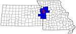 | |
| Largest cities (over 100,000 in 2000) | ||
| Medium-sized cities (10,000 to 100,000 in 2000) | ||
| Smaller Cities (between 5,000 and 9,900 in 2010) | ||
| Counties | ||
Municipalities and communities of Caldwell County, Missouri, United States | ||
|---|---|---|
| Cities | Map of Missouri highlighting Caldwell County | |
| Townships | ||
| Unincorporated communities | ||
| Ghost town | ||

| Authority control |
|
|---|