Mercer County, Missouri
Mercer County is a county located in the northwestern portion of the U.S. state of Missouri. As of the 2010 census, the population was 3,785,[1] making it the second-least populous county in Missouri. Its county seat is Princeton.[2] The county was organized February 14, 1845 and named for General John F. Mercer of the Revolutionary War.
Mercer County | |
|---|---|
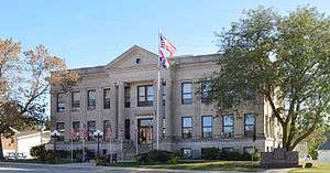 Mercer County Courthouse in downtown Princeton | |
 Location within the U.S. state of Missouri | |
 Missouri's location within the U.S. | |
| Coordinates: 40°25′N 93°34′W | |
| Country | |
| State | |
| Founded | February 14, 1845 |
| Named for | John Francis Mercer |
| Seat | Princeton |
| Largest city | Princeton |
| Area | |
| • Total | 455 sq mi (1,180 km2) |
| • Land | 454 sq mi (1,180 km2) |
| • Water | 1.3 sq mi (3 km2) 0.3% |
| Population (2010) | |
| • Total | 3,785 |
| • Estimate (2018) | 3,641 |
| • Density | 8.3/sq mi (3.2/km2) |
| Time zone | UTC−6 (Central) |
| • Summer (DST) | UTC−5 (CDT) |
| Congressional district | 6th |
History
Early years
Mercer County was organized February 14, 1845, from part of Grundy County.[3] It is named in honor of General John Francis Mercer, who fought and died in the American Revolutionary War. The first permanent settlements in what is now Mercer County were in 1837, when a few families from other parts of Missouri moved to the area. James Parsons, a Tennessee native, is generally considered to be the first permanent settler, in the spring of 1837.[4] The land was still included as part of Livingston County at that time and would remain so until 1841 when it would become part of the newly created Grundy County. Prior to 1837, the land was used by Native American tribes, primarily the Sac/Fox and Potawatomi, as prime hunting grounds. The occasional temporary hunting village would be established by the tribes; otherwise, the land was devoid of humans. The town of Princeton, named for the battle where General Mercer was killed, was established as the county seat in 1847.[5] The northern boundary of the county was in dispute for the first six years of its existence due to the Honey War, a bloodless territorial dispute between Missouri and Iowa. The boundary was 9.5 miles farther north than present day prior to an 1851 decision by the U.S. Supreme Court.
Civil War
Mercer County, like its neighbor to the east Putnam County, was a staunch supporter of the Union. Most county residents had roots in northern U.S. states "back east" like Pennsylvania, Ohio, and Indiana, and did not have the strong slave-holding tradition of other northern Missouri counties like Macon, Audrain, and Monroe (commonly referred to as Little Dixie), whose population largely emigrated from Southern states. In the 1860 U.S. Census, only 12 Mercer County families were listed as slave owners, with a combined total of 24 slaves.[6] Fewer than 20 Mercer County men fought for the Confederacy, while well over 1,000 volunteered for Union service. Among the units containing men from Mercer County were the 23rd, 27th and 35th Regiments, the 2nd and 12th Cavalry, the 5th Kansas Cavalry, and various smaller units of the Missouri State Militia.[7] The 44th Missouri Infantry (USA), consisting of men from Mercer, Grundy, Sullivan, and other northwest Missouri counties, served a pivotal role in the Union victory at the Battle of Franklin, TN, on November 30, 1864.
Geography
According to the U.S. Census Bureau, the county has a total area of 455 square miles (1,180 km2), of which 454 square miles (1,180 km2) is land and 1.3 square miles (3.4 km2) (0.3%) is water.[8]
Adjacent counties
- Decatur County, Iowa (northwest)
- Wayne County, Iowa (north)
- Putnam County (east)
- Sullivan County (southeast)
- Grundy County (south)
- Harrison County (west)
Major highways
Demographics
| Historical population | |||
|---|---|---|---|
| Census | Pop. | %± | |
| 1850 | 2,691 | — | |
| 1860 | 9,300 | 245.6% | |
| 1870 | 11,557 | 24.3% | |
| 1880 | 14,673 | 27.0% | |
| 1890 | 14,581 | −0.6% | |
| 1900 | 14,706 | 0.9% | |
| 1910 | 12,335 | −16.1% | |
| 1920 | 11,281 | −8.5% | |
| 1930 | 9,350 | −17.1% | |
| 1940 | 8,766 | −6.2% | |
| 1950 | 7,235 | −17.5% | |
| 1960 | 5,750 | −20.5% | |
| 1970 | 4,910 | −14.6% | |
| 1980 | 4,685 | −4.6% | |
| 1990 | 3,723 | −20.5% | |
| 2000 | 3,757 | 0.9% | |
| 2010 | 3,785 | 0.7% | |
| Est. 2018 | 3,641 | [9] | −3.8% |
| U.S. Decennial Census[10] 1790-1960[11] 1900-1990[12] 1990-2000[13] 2010-2015[1] | |||
As of the census[14] of 2010, there were 3,785 people, 1,600 households, and 1,089 families residing in the county. The population density was 8 people per square mile (3/km²). There were 2,125 housing units at an average density of 5 per square mile (2/km²). The racial makeup of the county was 98.72% White, 0.19% Black or African American, 0.56% Native American, 0.05% Pacific Islander, 0.03% from other races, and 0.45% from two or more races. Approximately 0.29% of the population were Hispanic or Latino of any race.
There were 1,600 households out of which 28.30% had children under the age of 18 living with them, 57.60% were married couples living together, 6.70% had a female householder with no husband present, and 31.90% were non-families. 29.30% of all households were made up of individuals and 17.60% had someone living alone who was 65 years of age or older. The average household size was 2.31 and the average family size was 2.83.
In the county, the population was spread out with 23.00% under the age of 18, 6.70% from 18 to 24, 24.20% from 25 to 44, 24.00% from 45 to 64, and 22.00% who were 65 years of age or older. The median age was 42 years. For every 100 females there were 95.70 males. For every 100 females age 18 and over, there were 92.60 males.
The median income for a household in the county was $29,640, and the median income for a family was $35,313. Males had a median income of $26,690 versus $19,814 for females. The per capita income for the county was $15,140. About 10.20% of families and 13.30% of the population were below the poverty line, including 13.30% of those under age 18 and 14.50% of those age 65 or over.
Education
- North Mercer County R-III School District - Mercer
- North Mercer County Elementary School (PK-06)
- Mercer High School (07-12)
- Princeton R-V School District - Princeton
- Princeton Elementary School (PK-06)
- Princeton High School (07-12)
Public libraries
- Mercer County Library[15]
Politics
Local
The Republican Party predominantly controls politics at the local level in Mercer County. Republicans hold all of the elected positions in the county. In the 2016 presidential election Mercer County had the highest Republican turnout in the state of Missouri with greater than 85% of the population voting for Donald Trump.
| Mercer County, Missouri | ||||
|---|---|---|---|---|
| Elected countywide officials | ||||
| Assessor | Diane Blunk | Republican | ||
| Circuit Clerk | Tammy Crouse | Republican | ||
| County Clerk | Judy Hamilton | Republican | ||
| Collector | Susan Moore | Republican | ||
| Commissioner (Presiding) |
Jerry Allen | Republican | ||
| Commissioner (District 1) |
Shane Grooms | Republican | ||
| Commissioner (District 2) |
Zachary Martin | Republican | ||
| Coroner | Douglas B. Priest | Republican | ||
| Prosecuting Attorney | Lauren Horseman | Republican | ||
| Public Administrator | Kelli Judd | Republican | ||
| Recorder | Tammy Crouse | Republican | ||
| Sheriff | Steve Stockman | Republican | ||
| Treasurer | Susan Moore | Republican | ||
State
| Year | Republican | Democratic | Third Parties |
|---|---|---|---|
| 2016 | 71.58% 1,224 | 26.61% 455 | 1.81% 31 |
| 2012 | 66.26% 1,090 | 30.58% 503 | 3.16% 52 |
| 2008 | 60.29% 1,043 | 35.84% 620 | 3.87% 67 |
| 2004 | 69.69% 1,237 | 29.24% 519 | 1.07% 19 |
| 2000 | 64.20% 1,144 | 34.01% 606 | 1.79% 32 |
| 1996 | 34.10% 516 | 64.24% 972 | 1.65% 25 |
All of Mercer County is a part of Missouri's 3rd District in the Missouri House of Representatives and is represented by Danny Busick (R-Newtown).
| Party | Candidate | Votes | % | ± | |
|---|---|---|---|---|---|
| Republican | Nate Walker | 1,510 | 100.00% | ||
| Party | Candidate | Votes | % | ± | |
|---|---|---|---|---|---|
| Republican | Nate Walker | 1,018 | 100.00% | +24.34 | |
| Party | Candidate | Votes | % | ± | |
|---|---|---|---|---|---|
| Republican | Nate Walker | 1,220 | 74.66% | ||
| Democratic | Rebecca McClanahan | 414 | 25.34% | ||
All of Mercer County is a part of Missouri’s 12th District in the Missouri Senate and is currently represented by Dan Hegeman (R-Cosby).
| Party | Candidate | Votes | % | ± | |
|---|---|---|---|---|---|
| Republican | Dan Hegeman | 986 | 100.00% | ||
Federal
| Party | Candidate | Votes | % | ± | |
|---|---|---|---|---|---|
| Republican | Roy Blunt | 1,231 | 72.37% | +22.34 | |
| Democratic | Jason Kander | 396 | 23.28% | -17.58 | |
| Libertarian | Jonathan Dine | 28 | 1.65% | -7.46 | |
| Green | Johnathan McFarland | 18 | 1.06% | +1.06 | |
| Constitution | Fred Ryman | 28 | 1.65% | +1.65 | |
| Party | Candidate | Votes | % | ± | |
|---|---|---|---|---|---|
| Republican | Todd Akin | 813 | 50.03% | ||
| Democratic | Claire McCaskill | 664 | 40.86% | ||
| Libertarian | Jonathan Dine | 148 | 9.11% | ||
All of Mercer County is included in Missouri’s 6th Congressional District and is currently represented by Sam Graves (R-Tarkio) in the U.S. House of Representatives.
| Party | Candidate | Votes | % | ± | |
|---|---|---|---|---|---|
| Republican | Sam Graves | 1,444 | 86.00% | +4.89 | |
| Democratic | David M. Blackwell | 197 | 11.73% | -2.66 | |
| Libertarian | Russ Lee Monchil | 30 | 1.79% | -2.71 | |
| Green | Mike Diel | 8 | 0.48% | +0.48 | |
| Party | Candidate | Votes | % | ± | |
|---|---|---|---|---|---|
| Republican | Sam Graves | 992 | 81.11% | +0.03 | |
| Democratic | Bill Hedge | 176 | 14.39% | -2.24 | |
| Libertarian | Russ Lee Monchil | 55 | 4.50% | +2.21 | |
| Party | Candidate | Votes | % | ± | |
|---|---|---|---|---|---|
| Republican | Sam Graves | 1,311 | 81.08% | ||
| Democratic | Kyle Yarber | 269 | 16.63% | ||
| Libertarian | Russ Lee Monchil | 37 | 2.29% | ||
| Year | Republican | Democratic | Third parties |
|---|---|---|---|
| 2016 | 85.2% 1,486 | 12.4% 216 | 2.5% 43 |
| 2012 | 75.8% 1,255 | 21.3% 353 | 2.8% 47 |
| 2008 | 66.9% 1,169 | 29.7% 519 | 3.4% 60 |
| 2004 | 66.4% 1,207 | 32.0% 582 | 1.5% 28 |
| 2000 | 67.9% 1,250 | 30.1% 555 | 2.0% 37 |
| 1996 | 41.8% 660 | 44.3% 700 | 14.0% 221 |
| 1992 | 33.9% 626 | 45.6% 843 | 20.6% 380 |
| 1988 | 49.9% 875 | 50.0% 877 | 0.1% 2 |
| 1984 | 58.4% 1,229 | 41.6% 875 | |
| 1980 | 58.7% 1,266 | 38.0% 821 | 3.3% 71 |
| 1976 | 46.4% 1,025 | 53.3% 1,177 | 0.2% 5 |
| 1972 | 72.4% 1,592 | 27.6% 607 | |
| 1968 | 60.8% 1,406 | 33.8% 783 | 5.4% 125 |
| 1964 | 44.8% 1,040 | 55.3% 1,284 | |
| 1960 | 67.3% 2,354 | 32.7% 1,146 | |
| 1956 | 64.7% 2,035 | 35.3% 1,109 | |
| 1952 | 72.4% 2,482 | 27.3% 936 | 0.3% 10 |
| 1948 | 61.2% 1,595 | 38.7% 1,008 | 0.1% 2 |
| 1944 | 68.4% 2,249 | 31.5% 1,035 | 0.1% 4 |
| 1940 | 67.0% 2,787 | 32.8% 1,364 | 0.2% 10 |
| 1936 | 59.9% 2,757 | 39.8% 1,834 | 0.3% 14 |
| 1932 | 46.8% 1,357 | 52.4% 1,520 | 0.8% 24 |
| 1928 | 75.5% 2,869 | 24.4% 925 | 0.1% 4 |
| 1924 | 62.5% 2,508 | 30.2% 1,209 | 7.3% 293 |
| 1920 | 74.2% 3,170 | 24.4% 1,044 | 1.4% 60 |
| 1916 | 61.1% 1,733 | 36.8% 1,042 | 2.1% 60 |
| 1912 | 34.9% 995 | 27.3% 780 | 37.8% 1,078 |
| 1908 | 68.1% 1,909 | 30.4% 852 | 1.5% 41 |
| 1904 | 68.2% 1,896 | 29.5% 819 | 2.4% 66 |
| 1900 | 62.8% 1,973 | 35.2% 1,106 | 2.0% 63 |
| 1896 | 57.7% 1,958 | 41.4% 1,405 | 0.9% 29 |
| 1892 | 55.8% 1,643 | 27.5% 809 | 16.8% 495 |
| 1888 | 62.9% 1,921 | 35.9% 1,097 | 1.2% 35 |
Missouri presidential preference primary (2008)
- Former U.S. Senator Hillary Clinton (D-New York) received more votes, a total of 141, than any candidate from either party in Mercer County during the 2008 presidential primary.
| Mercer County, Missouri | |
|---|---|
| 2008 Republican primary in Missouri | |
| John McCain | 114 (27.74%) |
| Mike Huckabee | 132 (32.12%) |
| Mitt Romney | 62 (15.09%) |
| Ron Paul | 91 (22.14%) |
| Mercer County, Missouri | |
|---|---|
| 2008 Democratic primary in Missouri | |
| Hillary Clinton | 141 (60.52%) |
| Barack Obama | 80 (34.33%) |
| John Edwards (withdrawn) | 10 (4.29%) |
Communities
Village
Census-designated place
Other communities
Historical communities
Source[17]
- Adel 40°31′53″N 93°40′08″W
- Alvord 40°27′20″N 93°35′43″W
- Burrows 40°30′58″N 93°45′20″W
- Cleopatra 40°32′55″N 93°24′15″W
- Dinsmore 40°20′28″N 93°44′41″W
- Goshen 40°22′58″N 93°40′46″W
- Half Rock 40°16′23″N 93°26′08″W
- Ilia 40°31′50″N 93°27′01″W
- Saline 40°31′37″N 93°43′40″W
- Topsy (Newtown) 40°21′11″N 93°28′47″W
- Wataga 40°33′38″N 93°37′59″W
See also
- National Register of Historic Places listings in Mercer County, Missouri
- Roy Alvin Baldwin, Texas state representative who co-authored the 1923 legislation establishing Texas Tech University, born at Half Rock in Mercer County in 1885
References
- "State & County QuickFacts". United States Census Bureau. Archived from the original on June 7, 2011. Retrieved September 10, 2013.
- "Find a County". National Association of Counties. Retrieved 2011-06-07.
- Missouri Secretary of State, Missouri History: What are the Origins of Missouri Counties?
- A Directory of Towns, Villages and Hamlets of Mercer County, Missouri by Arthur Paul Mosler.
- Encyclopedia of the History of Missouri, Edited by Howard L. Conard Vol. IV, Pages 327-328. Published 1901
- The Post-Telegraph newspaper, Mercer, Missouri. April 1960.
- Rogers' Souvenir History of Mercer County, by W.B. Rogers. 714 pages. Published 1911.
- "2010 Census Gazetteer Files". United States Census Bureau. August 22, 2012. Archived from the original on October 21, 2013. Retrieved November 16, 2014.
- "Population and Housing Unit Estimates". Retrieved November 15, 2019.
- "U.S. Decennial Census". United States Census Bureau. Archived from the original on June 7, 2011. Retrieved November 16, 2014.
- "Historical Census Browser". University of Virginia Library. Retrieved November 16, 2014.
- "Population of Counties by Decennial Census: 1900 to 1990". United States Census Bureau. Retrieved November 16, 2014.
- "Census 2000 PHC-T-4. Ranking Tables for Counties: 1990 and 2000" (PDF). United States Census Bureau. Retrieved November 16, 2014.
- "U.S. Census website". United States Census Bureau. Retrieved 2008-01-31.
- Breeding, Marshall. "Mercer County Library". Libraries.org. Retrieved May 8, 2017.
- Leip, David. "Dave Leip's Atlas of U.S. Presidential Elections". uselectionatlas.org. Retrieved 2018-03-25.
- USGenWeb: GNIS Query Results, Mercer County, Missouri
- USGenWeb Project, Mercer County, Missouri
External links
- Digitized 1930 Plat Book of Mercer County from University of Missouri Division of Special Collections, Archives, and Rare Books
Places adjacent to Mercer County, Missouri | ||||||||||
|---|---|---|---|---|---|---|---|---|---|---|
| ||||||||||
Municipalities and communities of Mercer County, Missouri, United States | ||
|---|---|---|
| Cities | Map of Missouri highlighting Mercer County | |
| Village | ||
| Townships | ||
| CDP | ||
| Other unincorporated communities | ||

| Authority control |
|
|---|