Osceola, Missouri
Osceola is a city in St. Clair County, Missouri, United States. The population was 947 at the 2010 census. It is the county seat of St. Clair County.[6] During the American Civil War, Osceola was the site of the Sacking of Osceola.
Osceola, Missouri | |
|---|---|
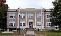 St. Clair County Courthouse in Osceola | |
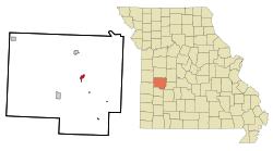 Location of Osceola, Missouri | |
| Coordinates: 38°2′47″N 93°41′58″W | |
| Country | United States |
| State | Missouri |
| County | St. Clair |
| Area | |
| • Total | 0.94 sq mi (2.43 km2) |
| • Land | 0.91 sq mi (2.36 km2) |
| • Water | 0.03 sq mi (0.08 km2) |
| Elevation | 751 ft (229 m) |
| Population | |
| • Total | 947 |
| • Estimate (2018)[3] | 905 |
| • Density | 1,000/sq mi (390/km2) |
| Time zone | UTC-6 (Central (CST)) |
| • Summer (DST) | UTC-5 (CDT) |
| ZIP code | 64776 |
| FIPS code | 29-55388[4] |
| GNIS feature ID | 0756486[5] |
History
Located on the Osage River, the land that became the town of Osceola was inhabited by the tribe of Osage Native Americans, also known as NiuKonska, Native Americans who gave the river its name. NiuKonska means "Little Ones of the Middle Waters". Two treaties, in 1808 and 1825, signed by the Osage and the U.S. government gave up all the tribe's land in Missouri. With the way cleared for non-native settlers, more people began to arrive in the St. Clair County area in the mid-1830s.
The town was the site of the September 1861 Sacking of Osceola by Jayhawkers (anti-slavery patrols) in which the town was burned and its courthouse looted. The event inspired the 1976 Clint Eastwood film The Outlaw Josey Wales. Prior to the attack the town had a population of around 2,500. However, fewer than 200 residents remained after the event and the population has never again approached those numbers.
In September 2011, on the 150th anniversary of the Sacking of Osceola, the Osceola Board of Aldermen passed a resolution asking the University of Kansas to no longer to use "Jayhawk" as its mascot and nickname. Further, the resolution asks Missouri residents to stop spelling Kansas or "KU" with a capital letter because "neither is a proper name or a proper place".[7]
The Osceola Public School Building was added to the National Register of Historic Places in 1999.[8]
Geography
Osceola is located at 38°2′47″N 93°41′58″W (38.046427, -93.699512).[9] According to the United States Census Bureau, the city has a total area of 0.94 square miles (2.43 km2), of which 0.91 square miles (2.36 km2) is land and 0.03 square miles (0.08 km2) is water.[1]
Demographics
| Historical population | |||
|---|---|---|---|
| Census | Pop. | %± | |
| 1860 | 314 | — | |
| 1870 | 331 | 5.4% | |
| 1880 | 373 | 12.7% | |
| 1890 | 995 | 166.8% | |
| 1900 | 1,037 | 4.2% | |
| 1910 | 1,114 | 7.4% | |
| 1920 | 1,025 | −8.0% | |
| 1930 | 1,043 | 1.8% | |
| 1940 | 1,190 | 14.1% | |
| 1950 | 1,082 | −9.1% | |
| 1960 | 1,066 | −1.5% | |
| 1970 | 874 | −18.0% | |
| 1980 | 841 | −3.8% | |
| 1990 | 755 | −10.2% | |
| 2000 | 835 | 10.6% | |
| 2010 | 947 | 13.4% | |
| Est. 2018 | 905 | [3] | −4.4% |
| U.S. Decennial Census[10] | |||
2010 census
As of the census[2] of 2010, there were 947 people, 394 households, and 225 families living in the city. The population density was 1,040.7 inhabitants per square mile (401.8/km2). There were 502 housing units at an average density of 551.6 per square mile (213.0/km2). The racial makeup of the city was 94.2% White, 1.7% African American, 0.7% Native American, 0.1% Asian, 0.4% from other races, and 2.9% from two or more races. Hispanic or Latino of any race were 3.1% of the population.
There were 394 households of which 31.0% had children under the age of 18 living with them, 35.8% were married couples living together, 16.0% had a female householder with no husband present, 5.3% had a male householder with no wife present, and 42.9% were non-families. 39.6% of all households were made up of individuals and 22.1% had someone living alone who was 65 years of age or older. The average household size was 2.14 and the average family size was 2.81.
The median age in the city was 39.7 years. 21.9% of residents were under the age of 18; 8.2% were between the ages of 18 and 24; 27% were from 25 to 44; 22.8% were from 45 to 64; and 20.2% were 65 years of age or older. The gender makeup of the city was 50.2% male and 49.8% female.
2000 census
As of the census[4] of 2000, there were 835 people, 373 households, and 207 families living in the city. The population density was 896.1 people per square mile (346.7/km²). There were 472 housing units at an average density of 506.5 per square mile (196.0/km²). The racial makeup of the city was 97.37% White, 0.36% African American, 0.60% Native American, 0.24% Asian, 0.12% Pacific Islander, 0.48% from other races, and 0.84% from two or more races. Hispanic or Latino of any race were 1.08% of the population.
There were 373 households out of which 26.8% had children under the age of 18 living with them, 40.2% were married couples living together, 12.9% had a female householder with no husband present, and 44.5% were non-families. 39.1% of all households were made up of individuals and 22.8% had someone living alone who was 65 years of age or older. The average household size was 2.13 and the average family size was 2.86.
In the city, the population was spread out with 24.6% under the age of 18, 7.1% from 18 to 24, 26.9% from 25 to 44, 20.7% from 45 to 64, and 20.7% who were 65 years of age or older. The median age was 38 years. For every 100 females, there were 95.1 males. For every 100 females age 18 and over, there were 84.8 males.
The median income for a household in the city was $21,563, and the median income for a family was $27,250. Males had a median income of $26,786 versus $15,750 for females. The per capita income for the city was $17,247. About 13.5% of families and 19.1% of the population were below the poverty line, including 18.2% of those under age 18 and 12.9% of those age 65 or over.
Education
Public education in Osceola is administered by Osceola School District.[11]
Osceola has a public library, the Saint Clair County Library.[12]
Arts and culture
The Osceola Chamber of Commerce hosts various activities. The Osceola Rodeo is the biggest event of the year, and Rodeo Daze is held annually on Labor Day weekend. This event includes the street dance, turtle races, food vendors, and the Rodeo Daze Parade. The annual street dance is held on the Thursday before Labor Day.
In popular culture
Osceola is the birthplace of Rooster Cogburn in Charles Portis's 1968 novel True Grit.[13] The pillaging of Osceola by Kansas Jayhawkers and Red Legs is thought to have provided Cogburn's motive for taking part in William Quantrill's infamous sack of Lawrence, Kansas which serves as a biographical background to the story.[14]
Notable people
- Karolyn Grimes, child actress[15]
- Waldo P. Johnson, United States Senator
- Thomas Bailey Marquis, physician and writer
References
- "US Gazetteer files 2010". United States Census Bureau. Archived from the original on 2012-01-25. Retrieved 2012-07-08.
- "U.S. Census website". United States Census Bureau. Retrieved 2012-07-08.
- "Population and Housing Unit Estimates". Retrieved February 22, 2020.
- "U.S. Census website". United States Census Bureau. Retrieved 2008-01-31.
- "US Board on Geographic Names". United States Geological Survey. 2007-10-25. Retrieved 2008-01-31.
- "Find a County". National Association of Counties. Retrieved 2011-06-07.
- "Mo. town calls on KU to drop Jayhawk mascot". KSHB-TV aka "NBC Action News.com". 2011-09-17. Retrieved 2011-09-22.
- "National Register Information System". National Register of Historic Places. National Park Service. July 9, 2010.
- "US Gazetteer files: 2010, 2000, and 1990". United States Census Bureau. 2011-02-12. Retrieved 2011-04-23.
- "Census of Population and Housing". Census.gov. Retrieved June 4, 2015.
- "Homepage". Osceola School District. Retrieved 4 June 2019.
- "Missouri Public Libraries". PublicLibraries.com. Archived from the original on 10 June 2017. Retrieved 2 June 2019.
- True Grit. Overlook Press. 2004. ISBN 9781590206508. Retrieved 2011-11-04.
- "Rooster Redux". Anamnesis. 2011. Archived from the original on 2011-09-18. Retrieved 2011-11-04.
- Curran, Thomas P. (26 January 2016). Millionaire Legacy: 8 Millionaire Success Strategies for Achieving Financial and Emotional Wealth. Morgan James Publishing. p. 186. ISBN 978-1-63047-670-0.
External links
- Official city website:
- Osceola Chamber of Commerce:
- National Control Devices :
- Historic maps of Osceola in the Sanborn Maps of Missouri Collection at the University of Missouri
Municipalities and communities of St. Clair County, Missouri, United States | ||
|---|---|---|
| Cities |  Map of Missouri highlighting Saint Clair County | |
| Villages | ||
| Townships | ||
| Unincorporated communities | ||
| Ghost towns | ||