Bowling Green, Missouri
Bowling Green is a city in Pike County, Missouri, United States. The population was 5,334 at the 2010 census. It is the county seat of Pike County.[6]
Bowling Green, Missouri | |
|---|---|
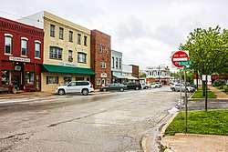 Bowling Green, Missouri in 2015 | |
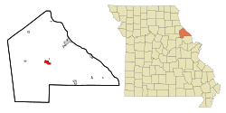 Location of Bowling Green, Missouri | |
| Coordinates: 39°20′30″N 91°12′0″W | |
| Country | United States |
| State | Missouri |
| County | Pike |
| Area | |
| • Total | 2.70 sq mi (7.00 km2) |
| • Land | 2.69 sq mi (6.97 km2) |
| • Water | 0.01 sq mi (0.04 km2) |
| Elevation | 892 ft (272 m) |
| Population | |
| • Total | 5,334 |
| • Estimate (2018)[3] | 5,624 |
| • Density | 2,062.10/sq mi (796.11/km2) |
| Time zone | UTC-6 (Central (CST)) |
| • Summer (DST) | UTC-5 (CDT) |
| ZIP code | 63334 |
| Area code(s) | 573 |
| FIPS code | 29-07660[4] |
| GNIS feature ID | 0714585[5] |
| Website | http://www.bowlinggreen-mo.gov/ |
History
Bowling Green was settled in 1819, and designated county seat in 1824.[7] Settled chiefly by migrants from Kentucky and Virginia, it was named after Bowling Green, Kentucky.[8][9]
The James Beauchamp Clark House was listed on the National Register of Historic Places in 1976.[10]
Geography
Bowling Green is located at 39°20′30″N 91°12′0″W (39.341597, -91.200076).[11] According to the United States Census Bureau, the city has a total area of 2.70 square miles (6.99 km2), of which, 2.69 square miles (6.97 km2) is land and 0.01 square miles (0.03 km2) is water.[12]
Bowling Green lies at the junction of US highways 54 and 61. US 54 links Bowling Green with Illinois to the east and Jefferson City and the Lake of the Ozarks to the south and west, while US 61 connects the city with Hannibal to the north and the St. Louis area to the south.
Demographics
| Historical population | |||
|---|---|---|---|
| Census | Pop. | %± | |
| 1850 | 319 | — | |
| 1860 | 379 | 18.8% | |
| 1870 | 599 | 58.0% | |
| 1880 | 1,067 | 78.1% | |
| 1890 | 1,564 | 46.6% | |
| 1900 | 1,902 | 21.6% | |
| 1910 | 1,585 | −16.7% | |
| 1920 | 1,965 | 24.0% | |
| 1930 | 1,855 | −5.6% | |
| 1940 | 1,975 | 6.5% | |
| 1950 | 2,396 | 21.3% | |
| 1960 | 2,650 | 10.6% | |
| 1970 | 2,936 | 10.8% | |
| 1980 | 3,022 | 2.9% | |
| 1990 | 2,976 | −1.5% | |
| 2000 | 3,260 | 9.5% | |
| 2010 | 5,334 | 63.6% | |
| Est. 2018 | 5,624 | [3] | 5.4% |
| U.S. Decennial Census[13] | |||
2010 census
As of the census[2] of 2010, there were 5,334 people, 1,316 households, and 810 families living in the city. The population density was 1,982.9 inhabitants per square mile (765.6/km2). There were 1,474 housing units at an average density of 548.0 per square mile (211.6/km2). The racial makeup of the city was 79.4% White, 18.4% African American, 0.1% Native American, 0.3% Asian, 0.5% from other races, and 1.2% from two or more races. Hispanic or Latino of any race were 1.8% of the population.
There were 1,316 households, of which 35.9% had children under the age of 18 living with them, 38.8% were married couples living together, 16.9% had a female householder with no husband present, 5.9% had a male householder with no wife present, and 38.4% were non-families. 31.9% of all households were made up of individuals, and 13.2% had someone living alone who was 65 years of age or older. The average household size was 2.46 and the average family size was 3.06.
The median age in the city was 35.9 years. 17% of residents were under the age of 18; 11.4% were between the ages of 18 and 24; 35.2% were from 25 to 44; 25.3% were from 45 to 64; and 11.1% were 65 years of age or older. The gender makeup of the city was 66.2% male and 33.8% female.
2000 census
As of the census[4] of 2000, there were 3,260 people, 1,290 households, and 798 families living in the city. The population density was 1,677.0 people per square mile (648.8/km2). There were 1,420 housing units at an average density of 730.5 per square mile (282.6/km2). The racial makeup of the city was 90.64% White, 7.67% African American, 0.12% Native American, 0.18% Asian, 0.21% from other races, and 1.17% from two or more races. Hispanic or Latino of any race were 0.74% of the population.
There were 1,290 households, out of which 32.5% had children under the age of 18 living with them, 42.9% were married couples living together, 14.7% had a female householder with no husband present, and 38.1% were non-families. 32.9% of all households were made up of individuals, and 16.1% had someone living alone who was 65 years of age or older. The average household size was 2.38 and the average family size was 3.03.
In the city, the population was spread out, with 27.2% under the age of 18, 8.6% from 18 to 24, 26.6% from 25 to 44, 19.3% from 45 to 64, and 18.3% who were 65 years of age or older. The median age was 36 years. For every 100 females, there were 85.9 males. For every 100 females age 18 and over, there were 80.6 males.
The median income for a household in the city was $27,287, and the median income for a family was $36,619. Males had a median income of $28,871 versus $18,873 for females. The per capita income for the city was $14,670. About 10.5% of families and 13.1% of the population were below the poverty line, including 14.4% of those under age 18 and 15.6% of those age 65 or over.
Education
Bowling Green R-1 School District operates two elementary schools, one middle school and Bowling Green High School.[14]
The town has a lending library, the Bowling Green Public Library.[15]
Notable residents
- James Overton Broadhead, House of Representatives, Missouri Senate, 1st president of the American Bar Association.
- Bennett Champ Clark, United States Senator (1933–1945), United States Circuit Judge (1945–1954).
- Champ Clark, Speaker of the House of Representatives.
- Jack Dougherty, American actor.
- Cotton Fitzsimmons, NBA Coach. 832 wins in the NBA. Graduated from Bowling Green High School in 1949.
- William L. Hungate, United States Representative (1964–1977), United States federal judge (1979–1992). Graduated from Bowling Green High School in 1940.
- Glenn Jacobs, professional wrestler for the WWE, Kane. Mayor of Knox County, Kentucky (2017–present)
- Virginia Kirtley, American actress and writer.
- Arthur Murray, Major General, United States Army. Years of service: 1878–1915, 1917–1918.
- Sterling Price, Major General, 11th Governor of Missouri (1853-1857).
- William R. Purnell, United States Admiral. Years of service: 1910–1946.
- James Earl Ray, moved with his family to the community from Alton, Illinois at age 2. At age 7 he moved with his family to Ewing, Missouri.[16]
- Raymond Phillips Sanderson, American sculptor and painter.
- Genevieve Clark Thomson, American suffragist.
References
- "2017 U.S. Gazetteer Files". United States Census Bureau. Retrieved Jan 10, 2019.
- "U.S. Census website". United States Census Bureau. Retrieved 2012-07-08.
- "Population and Housing Unit Estimates". Retrieved September 16, 2019.
- "U.S. Census website". United States Census Bureau. Retrieved 2008-01-31.
- "US Board on Geographic Names". United States Geological Survey. 2007-10-25. Retrieved 2008-01-31.
- "Find a County". National Association of Counties. Archived from the original on 2011-05-31. Retrieved 2011-06-07.
- Eaton, David Wolfe (1917). How Missouri Counties, Towns and Streams Were Named. The State Historical Society of Missouri. pp. 341.
- Ramsay, Robert L. (1952). Our Storehouse of Missouri Place Names. University of Missouri Press. p. 22.
- Earngey, Bill (1995). Missouri Roadsides: The Traveler's Companion. University of Missouri Press. p. 24.
- "National Register Information System". National Register of Historic Places. National Park Service. July 9, 2010.
- "US Gazetteer files: 2010, 2000, and 1990". United States Census Bureau. 2011-02-12. Retrieved 2011-04-23.
- "US Gazetteer files 2010". United States Census Bureau. Archived from the original on 2012-01-25. Retrieved 2012-07-08.
- "Census of Population and Housing". Census.gov. Retrieved June 4, 2015.
- "Bowling Green R-I School District". Greatschools. Retrieved 18 March 2018.
- "Missouri Public Libraries". PublicLibraries.com. Archived from the original on 10 June 2017. Retrieved 18 March 2018.
- http://www.memphishistory.org/People/Notorious/JamesEarlRay/tabid/186/Default.aspx
External links
- Historic maps of Bowling Green in the Sanborn Maps of Missouri Collection at the University of Missouri
Municipalities and communities of Pike County, Missouri, United States | ||
|---|---|---|
| Cities |  Map of Missouri highlighting Pike County | |
| Villages | ||
| Townships | ||
| CDPs | ||
| Unincorporated communities | ||
| Ghost towns | ||