Benton County, Missouri
Benton County is a county located in the west central part of the U.S. state of Missouri. The population was 19,056 as of the 2010 Census.[2] Its county seat is Warsaw.[3] The county was organized January 3, 1835, and named for U.S. Senator Thomas Hart Benton of Missouri.[4]
Benton County | |
|---|---|
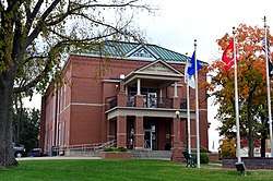 Benton County courthouse in Warsaw | |
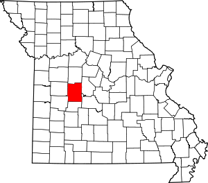 Location within the U.S. state of Missouri | |
 Missouri's location within the U.S. | |
| Coordinates: 38°18′N 93°17′W | |
| Country | |
| State | |
| Founded | January 3, 1835 |
| Named for | Thomas Hart Benton |
| Seat | Warsaw |
| Largest city | Warsaw |
| Area | |
| • Total | 753 sq mi (1,950 km2) |
| • Land | 704 sq mi (1,820 km2) |
| • Water | 48 sq mi (120 km2) 6.4% |
| Population (2010) | |
| • Total | 19,056 |
| • Estimate (2018)[1] | 19,278 |
| • Density | 25/sq mi (9.8/km2) |
| Time zone | UTC−6 (Central) |
| • Summer (DST) | UTC−5 (CDT) |
| Congressional district | 4th |
| Website | www |
Geography
According to the U.S. Census Bureau, the county has a total area of 753 square miles (1,950 km2), of which 704 square miles (1,820 km2) is land and 48 square miles (120 km2) (6.4%) is water.[5]
Adjacent counties
- Pettis County (north)
- Morgan County (northeast)
- Camden County (southeast)
- Hickory County (south)
- St. Clair County (southwest)
- Henry County (west)
Demographics
| Historical population | |||
|---|---|---|---|
| Census | Pop. | %± | |
| 1840 | 4,205 | — | |
| 1850 | 5,015 | 19.3% | |
| 1860 | 9,072 | 80.9% | |
| 1870 | 11,322 | 24.8% | |
| 1880 | 12,396 | 9.5% | |
| 1890 | 14,973 | 20.8% | |
| 1900 | 16,556 | 10.6% | |
| 1910 | 14,881 | −10.1% | |
| 1920 | 12,989 | −12.7% | |
| 1930 | 11,708 | −9.9% | |
| 1940 | 11,142 | −4.8% | |
| 1950 | 9,080 | −18.5% | |
| 1960 | 8,737 | −3.8% | |
| 1970 | 9,695 | 11.0% | |
| 1980 | 12,183 | 25.7% | |
| 1990 | 13,859 | 13.8% | |
| 2000 | 17,180 | 24.0% | |
| 2010 | 19,056 | 10.9% | |
| Est. 2018 | 19,278 | [6] | 1.2% |
| U.S. Decennial Census[7] 1790-1960[8] 1900-1990[9] 1990-2000[10] 2010-2015[2] | |||
As of the census[11] of 2000, there were 17,180 people, 7,420 households, and 5,179 families residing in the county. The population density was 24 people per square mile (9/km²). There were 12,691 housing units at an average density of 18 per square mile (7/km²). The racial makeup of the county was 97.96% White, 0.15% Black or African American, 0.53% Native American, 0.13% Asian, 0.01% Pacific Islander, 0.12% from other races, and 1.10% from two or more races. Approximately 0.89% of the population were Hispanic or Latino of any race.
There were 7,420 households out of which 23.20% had children under the age of 18 living with them, 59.60% were married couples living together, 6.80% had a female householder with no husband present, and 30.20% were non-families. 26.30% of all households were made up of individuals and 13.80% had someone living alone who was 65 years of age or older. The average household size was 2.28 and the average family size was 2.72.
In the county, the population was spread out with 20.50% under the age of 18, 5.70% from 18 to 24, 21.80% from 25 to 44, 29.70% from 45 to 64, and 22.30% who were 65 years of age or older. The median age was 46 years. For every 100 females there were 98.20 males. For every 100 females age 18 and over, there were 96.70 males.
The median income for a household in the county was $26,646, and the median income for a family was $32,459. Males had a median income of $26,203 versus $19,054 for females. The per capita income for the county was $15,457. About 10.20% of families and 15.70% of the population were below the poverty line, including 24.50% of those under age 18 and 9.60% of those age 65 or over.
Education
Public schools
- Cole Camp R-I School District – Cole Camp
- Cole Camp Elementary School (PK-05)
- Cole Camp Middle School (06-08)
- Cole Camp High School (09-12)
- Lincoln R-II School District – Lincoln
- Lincoln Elementary School (K-06)
- Lincoln High School (07-12)
- Warsaw R-IX School District – Warsaw
- Ruth Mercer Elementary School (K-02)
- North Elementary School (PK-05)
- South Elementary School (PK-05)
- John Boise Middle School (06-08)
- Warsaw High School (09-12)
Private schools
Public libraries
- Boonslick Regional Library[12]
Politics
Local
The Republican Party predominantly controls politics at the local level in Benton County. Republicans hold all but one of the elected positions in the county.
| Benton County, Missouri | ||||
|---|---|---|---|---|
| Elected countywide officials | ||||
| Assessor | Jim Hansen | Republican | ||
| Circuit Clerk | Cheryl Schultz | Republican | ||
| County Clerk | Susan Porterfield | Republican | ||
| Collector | David Brodersen | Republican | ||
| Commissioner (Presiding) |
Steve Daleske | Republican | ||
| Commissioner (District 1) |
Vacant | Republican | ||
| Commissioner (District 2) |
Dale Jr Estes | Republican | ||
| Coroner | J. Weston Miller | Republican | ||
| Prosecuting Attorney | Karen Coffey Woodley | Republican | ||
| Public Administrator | Lori Dunkin | Republican | ||
| Recorder | Carla Brown | Republican | ||
| Sheriff | Eric Knox | Republican | ||
| Surveyor | Jesse Wininger | Republican | ||
| Treasurer | Rick Renno | Republican | ||
State
| Year | Republican | Democratic | Third Parties |
|---|---|---|---|
| 2016 | 63.41% 6,047 | 33.55% 3,199 | 3.04% 290 |
| 2012 | 50.94% 4,641 | 46.25% 4,213 | 2.81% 256 |
| 2008 | 41.57% 3,967 | 56.09% 5,353 | 2.34% 223 |
| 2004 | 56.67% 5,088 | 41.95% 3,767 | 1.39% 124 |
| 2000 | 52.76% 3,944 | 45.58% 3,407 | 1.66% 124 |
| 1996 | 44.36% 2,979 | 52.42% 3,520 | 3.22% 216 |
Benton County is split between two of Missouri’s legislative districts that elect members of the Missouri House of Representatives. Both are represented by Republicans.
- District 57 — Wanda Brown (R-Lincoln). Consists of the northern half of the county, including Cole Camp, Ionia, and Lincoln.
| Party | Candidate | Votes | % | ± | |
|---|---|---|---|---|---|
| Republican | Wanda Brown | 3,026 | 73.32% | -2.99 | |
| Democratic | William A. Grimes | 1,101 | 26.68% | +7.97 | |
| Party | Candidate | Votes | % | ± | |
|---|---|---|---|---|---|
| Republican | Wanda Brown | 1,672 | 76.31% | +5.37 | |
| Democratic | William A. Grimes | 410 | 18.71% | -10.35 | |
| Constitution | Butch Page | 109 | 4.98% | +4.98 | |
| Party | Candidate | Votes | % | ± | |
|---|---|---|---|---|---|
| Republican | Wanda Brown | 2,803 | 70.94% | ||
| Democratic | Don Bullock | 1,148 | 29.06% | ||
- District 125 — Warren Love (R-Osceola). Consists of the southern half of the county, including Edwards and Warsaw.
| Party | Candidate | Votes | % | ± | |
|---|---|---|---|---|---|
| Republican | Warren D. Love | 4,539 | 100.00% | ||
| Party | Candidate | Votes | % | ± | |
|---|---|---|---|---|---|
| Republican | Warren D. Love | 2,069 | 100.00% | ||
| Party | Candidate | Votes | % | ± | |
|---|---|---|---|---|---|
| Republican | Warren D. Love | 4,160 | 100.00% | ||
All of Benton County is a part of Missouri’s 28th District in the Missouri Senate. The seat is currently vacant. The previous incumbent, Mike Parson, was elected Lieutenant Governor in 2016.
| Party | Candidate | Votes | % | ± | |
|---|---|---|---|---|---|
| Republican | Mike Parson | 3,956 | 100.00% | ||
Federal
| Party | Candidate | Votes | % | ± | |
|---|---|---|---|---|---|
| Republican | Roy Blunt | 5,891 | 61.87% | +14.66 | |
| Democratic | Jason Kander | 3,097 | 32.52% | -12.55 | |
| Libertarian | Jonathan Dine | 300 | 3.15% | -4.57 | |
| Green | Johnathan McFarland | 103 | 1.08% | +1.08 | |
| Constitution | Fred Ryman | 131 | 1.38% | +1.38 | |
| Party | Candidate | Votes | % | ± | |
|---|---|---|---|---|---|
| Republican | Todd Akin | 4,277 | 47.21% | ||
| Democratic | Claire McCaskill | 4,083 | 45.07% | ||
| Libertarian | Jonathan Dine | 699 | 7.72% | ||
All of Benton County is included in Missouri’s 4th Congressional District and is currently represented by Vicky Hartzler (R-Harrisonville) in the U.S. House of Representatives.
| Party | Candidate | Votes | % | ± | |
|---|---|---|---|---|---|
| Republican | Vicky Hartzler | 6,928 | 73.73% | -0.58 | |
| Democratic | Gordon Christensen | 2,056 | 21.88% | +0.92 | |
| Libertarian | Mark Bliss | 413 | 4.39% | -0.34 | |
| Party | Candidate | Votes | % | ± | |
|---|---|---|---|---|---|
| Republican | Vicky Hartzler | 3,566 | 74.31% | +7.21 | |
| Democratic | Nate Irvin | 1,006 | 20.96% | -8.89 | |
| Libertarian | Herschel L. Young | 227 | 4.73% | +2.14 | |
| Party | Candidate | Votes | % | ± | |
|---|---|---|---|---|---|
| Republican | Vicky Hartzler | 6,044 | 67.10% | ||
| Democratic | Teresa Hensley | 2,689 | 29.85% | ||
| Libertarian | Thomas Holbrook | 233 | 2.59% | ||
| Constitution | Greg Cowan | 41 | 0.46% | ||
Political culture
| Year | Republican | Democratic | Third parties |
|---|---|---|---|
| 2016 | 75.2% 7,213 | 21.1% 2,025 | 3.7% 352 |
| 2012 | 66.3% 6,069 | 31.9% 2,925 | 1.8% 163 |
| 2008 | 59.9% 5,759 | 37.8% 3,629 | 2.3% 223 |
| 2004 | 61.9% 5,575 | 37.5% 3,381 | 0.6% 53 |
| 2000 | 56.0% 4,218 | 41.8% 3,150 | 2.2% 166 |
| 1996 | 43.1% 2,895 | 44.6% 2,996 | 12.3% 824 |
| 1992 | 34.5% 2,511 | 43.9% 3,195 | 21.6% 1,570 |
| 1988 | 56.4% 3,467 | 43.2% 2,654 | 0.4% 24 |
| 1984 | 62.8% 3,805 | 37.2% 2,251 | |
| 1980 | 59.0% 3,451 | 38.3% 2,241 | 2.7% 160 |
| 1976 | 51.5% 2,875 | 48.0% 2,684 | 0.5% 28 |
| 1972 | 71.3% 3,537 | 28.7% 1,423 | |
| 1968 | 61.1% 2,899 | 28.4% 1,345 | 10.5% 498 |
| 1964 | 55.0% 2,477 | 45.0% 2,030 | |
| 1960 | 70.0% 3,484 | 30.0% 1,496 | |
| 1956 | 66.8% 3,145 | 33.2% 1,563 | |
| 1952 | 72.3% 3,470 | 27.2% 1,303 | 0.5% 26 |
| 1948 | 67.0% 2,768 | 32.9% 1,360 | 0.1% 3 |
| 1944 | 74.7% 3,294 | 25.1% 1,108 | 0.1% 6 |
| 1940 | 68.7% 3,912 | 31.0% 1,765 | 0.3% 18 |
| 1936 | 63.1% 3,375 | 36.5% 1,950 | 0.4% 21 |
| 1932 | 43.6% 2,038 | 55.6% 2,596 | 0.8% 38 |
| 1928 | 72.3% 3,411 | 27.5% 1,296 | 0.2% 9 |
| 1924 | 60.7% 2,693 | 35.8% 1,588 | 3.5% 155 |
| 1920 | 68.5% 3,367 | 30.6% 1,506 | 0.9% 42 |
| 1916 | 57.9% 1,842 | 40.4% 1,285 | 1.8% 56 |
| 1912 | 37.4% 1,142 | 39.6% 1,209 | 23.1% 704 |
| 1908 | 59.1% 1,924 | 39.3% 1,280 | 1.6% 52 |
| 1904 | 57.0% 1,963 | 39.8% 1,372 | 3.2% 109 |
| 1900 | 54.4% 1,980 | 42.1% 1,532 | 3.5% 128 |
| 1896 | 51.8% 1,957 | 46.6% 1,762 | 1.7% 63 |
| 1892 | 51.0% 1,570 | 34.4% 1,058 | 14.6% 450 |
| 1888 | 54.3% 1,704 | 43.8% 1,374 | 2.0% 62 |
Missouri Presidential Preference Primary (2008)
- Former U.S. Senator Hillary Clinton (D-New York) received more votes, a total of 1,753, than any candidate from either party in Benton County during the 2008 presidential primary.
| Benton County, Missouri | |
|---|---|
| 2008 Republican primary in Missouri | |
| John McCain | 803 (34.67%) |
| Mike Huckabee | 824 (35.58%) |
| Mitt Romney | 580 (25.04%) |
| Ron Paul | 75 (3.24%) |
| Benton County, Missouri | |
|---|---|
| 2008 Democratic primary in Missouri | |
| Hillary Clinton | 1,753 (68.77%) |
| Barack Obama | 687 (26.95%) |
| John Edwards (withdrawn) | 80 (3.14%) |
See also
- National Register of Historic Places listings in Benton County, Missouri
References
- "Population and Housing Unit Estimates". Retrieved June 9, 2017.
- "State & County QuickFacts". United States Census Bureau. Retrieved September 7, 2013.
- "Find a County". National Association of Counties. Archived from the original on 2011-05-31. Retrieved 2011-06-07.
- Eaton, David Wolfe (1916). How Missouri Counties, Towns and Streams Were Named. The State Historical Society of Missouri. pp. 209.
- "2010 Census Gazetteer Files". United States Census Bureau. August 22, 2012. Archived from the original on October 21, 2013. Retrieved November 13, 2014.
- "Population and Housing Unit Estimates". Retrieved November 29, 2019.
- "U.S. Decennial Census". United States Census Bureau. Retrieved November 13, 2014.
- "Historical Census Browser". University of Virginia Library. Retrieved November 13, 2014.
- "Population of Counties by Decennial Census: 1900 to 1990". United States Census Bureau. Retrieved November 13, 2014.
- "Census 2000 PHC-T-4. Ranking Tables for Counties: 1990 and 2000" (PDF). United States Census Bureau. Retrieved November 13, 2014.
- "U.S. Census website". United States Census Bureau. Retrieved 2011-05-14.
- Breeding, Marshall. "Boonslick Regional Library". Libraries.org. Retrieved May 8, 2017.
- "County Results - State of Missouri - 2016 General Election - November 8, 2016 - Official Results". Missouri Secretary of State. December 12, 2016. Retrieved April 28, 2017.
- Leip, David. "Dave Leip's Atlas of U.S. Presidential Elections". uselectionatlas.org. Retrieved 2018-03-24.
Further reading
- History of Cole, Moniteau, Morgan, Benton, Miller, Maries and Osage counties, Missouri : from the earliest time to the present, including a department devoted to the preservation of sundry personal, business, professional and the private records; besides a valuable fund of notes, original observations, etc. etc. (1889) online
External links
- http://www.hearthstonelegacy.com/benton.htm
- Benton County Courthouse Official Website
- Digitized 1930 Plat Book of Benton County from University of Missouri Division of Special Collections, Archives, and Rare Books
Places adjacent to Benton County, Missouri | ||||||||||
|---|---|---|---|---|---|---|---|---|---|---|
| ||||||||||
Municipalities and communities of Benton County, Missouri, United States | ||
|---|---|---|
| Cities | Map of Missouri highlighting Benton County | |
| Village | ||
| Townships | ||
| Unincorporated communities |
| |
| Former settlements | ||
| Footnotes | ‡This populated place also has portions in an adjacent county or counties | |

| Authority control |
|
|---|