Laclede County, Missouri
Laclede County is a county located in the U.S. state of Missouri. As of the 2010 census, the population was 35,571.[1] Its county seat is Lebanon.[2] The county was organized February 24, 1849, and was named after Pierre Laclède, founder of St. Louis.[3]
Laclede County | |
|---|---|
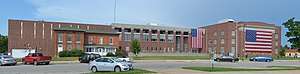 Laclede County Courthouse in Lebanon | |
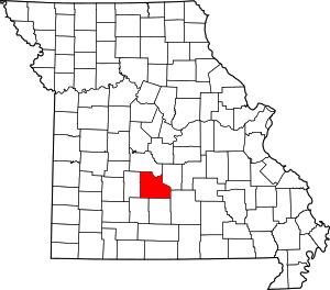 Location within the U.S. state of Missouri | |
 Missouri's location within the U.S. | |
| Coordinates: 37°40′N 92°35′W | |
| Country | |
| State | |
| Founded | February 24, 1849 |
| Named for | Pierre Laclede |
| Seat | Lebanon |
| Largest city | Lebanon |
| Area | |
| • Total | 768 sq mi (1,990 km2) |
| • Land | 765 sq mi (1,980 km2) |
| • Water | 3.3 sq mi (9 km2) 0.4% |
| Population (2010) | |
| • Total | 35,571 |
| • Estimate (2018) | 35,713 |
| • Density | 46/sq mi (18/km2) |
| Time zone | UTC−6 (Central) |
| • Summer (DST) | UTC−5 (CDT) |
| Congressional district | 4th |
| Website | lacledecountymissouri |
Laclede County comprises the Lebanon, MO Micropolitan Statistical Area.
Geography
According to the U.S. Census Bureau, the county has a total area of 768 square miles (1,990 km2), of which 765 square miles (1,980 km2) is land and 3.3 square miles (8.5 km2) (0.4%) is water.[4]
Adjacent counties
- Camden County (north)
- Pulaski County (northeast)
- Texas County (southeast)
- Wright County (south)
- Webster County (southwest)
- Dallas County (west)
National protected area
- Mark Twain National Forest (part)
Demographics
| Historical population | |||
|---|---|---|---|
| Census | Pop. | %± | |
| 1850 | 2,498 | — | |
| 1860 | 5,182 | 107.4% | |
| 1870 | 9,380 | 81.0% | |
| 1880 | 11,524 | 22.9% | |
| 1890 | 14,721 | 27.7% | |
| 1900 | 16,523 | 12.2% | |
| 1910 | 17,363 | 5.1% | |
| 1920 | 16,857 | −2.9% | |
| 1930 | 16,320 | −3.2% | |
| 1940 | 18,718 | 14.7% | |
| 1950 | 19,010 | 1.6% | |
| 1960 | 18,991 | −0.1% | |
| 1970 | 19,944 | 5.0% | |
| 1980 | 24,323 | 22.0% | |
| 1990 | 27,158 | 11.7% | |
| 2000 | 32,513 | 19.7% | |
| 2010 | 35,571 | 9.4% | |
| Est. 2018 | 35,713 | [5] | 0.4% |
| U.S. Decennial Census[6] 1790-1960[7] 1900-1990[8] 1990-2000[9] 2010-2015[1] | |||
As of the census[10] of 2000, there were 32,513 people, 12,760 households, and 9,187 families residing in the county. The population density was 42 people per square mile (16/km²). There were 14,320 housing units at an average density of 19 per square mile (7/km²). The racial makeup of the county was 97.04% White, 0.42% Black or African American, 0.49% Native American, 0.29% Asian, 0.05% Pacific Islander, 0.34% from other races, and 1.37% from two or more races. Approximately 1.23% of the population were Hispanic or Latino of any race.
There were 12,760 households out of which 33.90% had children under the age of 18 living with them, 58.90% were married couples living together, 9.40% had a female householder with no husband present, and 28.00% were non-families. 24.00% of all households were made up of individuals and 11.00% had someone living alone who was 65 years of age or older. The average household size was 2.52 and the average family size was 2.97.
In the county, the population was spread out with 26.70% under the age of 18, 8.40% from 18 to 24, 27.80% from 25 to 44, 22.90% from 45 to 64, and 14.10% who were 65 years of age or older. The median age was 37 years. For every 100 females there were 96.40 males. For every 100 females age 18 and over, there were 92.90 males.
The median income for a household in the county was $29,562, and the median income for a family was $35,962. Males had a median income of $27,011 versus $18,283 for females. The per capita income for the county was $15,572. About 11.50% of families and 14.30% of the population were below the poverty line, including 16.50% of those under age 18 and 15.90% of those age 65 or over.
Education
Public schools
- Laclede County R-I School District – Conway
- Ezard Elementary School (PK-06)
- Conway Junior High School (07-08)
- Conway High School (09-12)
- Gasconade C-4 School District – Falcon
- Gasconade Elementary School (PK-08)
- Lebanon R-III School District – Lebanon
- Joe D. Esther Elementary School (PK-01)
- Maplecrest Elementary School (02-03)
- Boswell Elementary School (04-05)
- Lebanon Middle School (06-08)
- Lebanon High School (09-12)
- Joel E. Barber C-5 School District - Lebanon
- Joel E. Barber Elementary School (PK-08)
- Stoutland R-II School District – Stoutland
- Stoutland Elementary School (PK-06)
- Stoutland High School (07-12)
Post Secondary Schools
Public libraries
- Lebanon-Laclede County Library[11]
Politics
Local
The Republican Party completely controls politics at the local level in Laclede County. Republicans hold all of the elected positions in the county.[12]
| Laclede County, Missouri | ||||
|---|---|---|---|---|
| Elected countywide officials | ||||
| Assessor | Johnny North | Republican | ||
| Circuit Clerk | Wanda Tyre | Republican | ||
| County Clerk | Glenda Mott | Republican | ||
| Collector | Steve Pickering | Republican | ||
| Commissioner (Presiding) |
Danny Rhoades | Republican | ||
| Commissioner (District 1) |
Joe Pickering | Republican | ||
| Commissioner (District 2) |
Jack Glendenning | Republican | ||
| Coroner | Steve Murrell | Republican | ||
| Prosecuting Attorney | Jon Morris | Republican | ||
| Public Administrator | Karen Guinn | Republican | ||
| Recorder | Lynn Stowe | Republican | ||
| Sheriff | Richard Wrinkle | Republican | ||
| Surveyor | Robert Shotts | Republican | ||
| Treasurer | Jean Cook | Republican | ||
State
| Year | Republican | Democratic | Third Parties |
|---|---|---|---|
| 2016 | 70.96% 11,362 | 25.74% 4,122 | 3.30% 528 |
| 2012 | 57.00% 8,751 | 39.91% 6,128 | 3.09% 474 |
| 2008 | 46.96% 7,604 | 50.90% 8,242 | 2.15% 348 |
| 2004 | 67.23% 9,993 | 31.78% 4,724 | 1.00% 148 |
| 2000 | 58.33% 7,595 | 39.28% 5,115 | 2.39% 311 |
| 1996 | 57.01% 6,525 | 40.46% 4,631 | 2.53% 289 |
Laclede County is split between two of Missouri's legislative districts that elect members of the Missouri House of Representatives, both of which are represented by Republicans.
- District 123 — Diane Franklin (R-Camdenton). Consists of the northern and eastern parts of the county, including Falcon and part of Lebanon.
| Party | Candidate | Votes | % | ± | |
|---|---|---|---|---|---|
| Republican | Diane Franklin | 6,194 | 100.00% | ||
| Party | Candidate | Votes | % | ± | |
|---|---|---|---|---|---|
| Republican | Diane Franklin | 2,659 | 100.00% | ||
| Party | Candidate | Votes | % | ± | |
|---|---|---|---|---|---|
| Republican | Diane Franklin | 5,801 | 100.00% | ||
- District 129 — Sandy Crawford (R-Buffalo). Consists of the southwestern part of the county, including Conway, Evergreen, Phillipsburg, and most of Lebanon.
| Party | Candidate | Votes | % | ± | |
|---|---|---|---|---|---|
| Republican | Sandy Crawford | 7,885 | 89.05% | +5.24 | |
| Independent | Charles Matranga | 970 | 10.95% | +10.95 | |
| Party | Candidate | Votes | % | ± | |
|---|---|---|---|---|---|
| Republican | Sandy Crawford | 3,281 | 83.81% | +7.27 | |
| Democratic | John L. Wilson | 634 | 16.19% | -7.27 | |
| Party | Candidate | Votes | % | ± | |
|---|---|---|---|---|---|
| Republican | Sandy Crawford | 6,509 | 76.54% | ||
| Democratic | John L. Wilson | 1,995 | 23.46% | ||
All of Laclede County is a part of Missouri's 28th District in the Missouri Senate. The seat is currently vacant. The previous incumbent, Mike Parson, was elected Lieutenant Governor in 2016.
| Party | Candidate | Votes | % | ± | |
|---|---|---|---|---|---|
| Republican | Mike Parson | 6,050 | 100.00% | ||
Federal
| Party | Candidate | Votes | % | ± | |
|---|---|---|---|---|---|
| Republican | Roy Blunt | 11,316 | 70.53% | +19.78 | |
| Democratic | Jason Kander | 3,965 | 24.71% | -16.52 | |
| Libertarian | Jonathan Dine | 396 | 2.47% | -5.54 | |
| Green | Johnathan McFarland | 180 | 1.12% | +1.12 | |
| Constitution | Fred Ryman | 186 | 1.16% | +1.16 | |
| Party | Candidate | Votes | % | ± | |
|---|---|---|---|---|---|
| Republican | Todd Akin | 7,721 | 50.75% | ||
| Democratic | Claire McCaskill | 6,278 | 41.23% | ||
| Libertarian | Jonathan Dine | 1,219 | 8.01% | ||
All of Laclede County is included in Missouri's 4th Congressional District and is currently represented by Vicky Hartzler (R-Harrisonville) in the U.S. House of Representatives.
| Party | Candidate | Votes | % | ± | |
|---|---|---|---|---|---|
| Republican | Vicky Hartzler | 12,908 | 81.49% | +0.49 | |
| Democratic | Gordon Christensen | 2,353 | 14.85% | +0.52 | |
| Libertarian | Mark Bliss | 580 | 3.66% | -0.92 | |
| Party | Candidate | Votes | % | ± | |
|---|---|---|---|---|---|
| Republican | Vicky Hartzler | 5,654 | 81.00% | +6.06 | |
| Democratic | Nate Irvin | 1,000 | 14.33% | -6.87 | |
| Libertarian | Herschel L. Young | 320 | 4.58% | +1.87 | |
| Write-in | Gregory A. Cowan | 6 | 0.09% | +0.09 | |
| Party | Candidate | Votes | % | ± | |
|---|---|---|---|---|---|
| Republican | Vicky Hartzler | 11,376 | 74.94% | ||
| Democratic | Teresa Hensley | 3,219 | 21.20% | ||
| Libertarian | Thomas Holbrook | 411 | 2.71% | ||
| Constitution | Gregory A. Cowan | 175 | 1.15% | ||
Political culture
| Year | Republican | Democratic | Third parties |
|---|---|---|---|
| 2016 | 79.8% 12,881 | 15.8% 2,553 | 4.4% 706 |
| 2012 | 70.8% 10,934 | 26.5% 4,093 | 2.6% 408 |
| 2008 | 66.4% 10,875 | 31.9% 5,218 | 1.8% 286 |
| 2004 | 71.1% 10,578 | 28.3% 4,213 | 0.5% 78 |
| 2000 | 65.6% 8,556 | 32.1% 4,183 | 2.4% 307 |
| 1996 | 51.2% 5,887 | 35.2% 4,047 | 13.6% 1,565 |
| 1992 | 42.4% 5,176 | 34.2% 4,179 | 23.5% 2,867 |
| 1988 | 63.7% 6,070 | 36.1% 3,442 | 0.3% 24 |
| 1984 | 70.6% 6,406 | 29.4% 2,665 | |
| 1980 | 60.8% 5,642 | 37.1% 3,443 | 2.1% 197 |
| 1976 | 48.0% 4,067 | 51.7% 4,381 | 0.3% 27 |
| 1972 | 73.8% 6,152 | 26.2% 2,186 | |
| 1968 | 56.1% 4,860 | 34.1% 2,958 | 9.8% 852 |
| 1964 | 46.0% 3,848 | 54.0% 4,517 | |
| 1960 | 64.8% 5,805 | 35.2% 3,156 | |
| 1956 | 60.7% 5,079 | 39.3% 3,287 | |
| 1952 | 65.1% 5,312 | 34.8% 2,839 | 0.1% 4 |
| 1948 | 53.8% 3,773 | 45.9% 3,221 | 0.3% 21 |
| 1944 | 60.8% 4,670 | 39.2% 3,011 | 0.1% 6 |
| 1940 | 59.7% 4,941 | 40.1% 3,323 | 0.2% 14 |
| 1936 | 53.4% 4,258 | 46.3% 3,691 | 0.4% 28 |
| 1932 | 41.1% 2,804 | 58.0% 3,960 | 0.9% 59 |
| 1928 | 65.9% 3,971 | 33.7% 2,031 | 0.4% 23 |
| 1924 | 51.6% 2,960 | 43.6% 2,500 | 4.8% 275 |
| 1920 | 60.3% 3,469 | 37.9% 2,183 | 1.8% 102 |
| 1916 | 50.3% 1,877 | 47.0% 1,755 | 2.7% 101 |
| 1912 | 39.8% 1,478 | 44.0% 1,634 | 16.1% 599 |
| 1908 | 51.9% 1,902 | 45.9% 1,681 | 2.2% 79 |
| 1904 | 53.9% 1,874 | 41.7% 1,450 | 4.3% 150 |
| 1900 | 47.7% 1,686 | 50.5% 1,786 | 1.8% 62 |
| 1896 | 42.6% 1,598 | 56.5% 2,120 | 0.9% 33 |
| 1892 | 43.1% 1,376 | 38.3% 1,223 | 18.6% 594 |
| 1888 | 44.8% 1,274 | 36.2% 1,030 | 19.0% 539 |
Missouri presidential preference primary (2008)
- Former Governor Mike Huckabee (R-Arkansas) received more votes, a total of 2,791, than any candidate from either party in Laclede County during the 2008 presidential primary.
| Laclede County, Missouri | |
|---|---|
| 2008 Republican primary in Missouri | |
| John McCain | 1,656 (30.21%) |
| Mike Huckabee | 2,791 (50.91%) |
| Mitt Romney | 807 (14.72%) |
| Ron Paul | 142 (2.59%) |
| Laclede County, Missouri | |
|---|---|
| 2008 Democratic primary in Missouri | |
| Hillary Clinton | 2,185 (62.48%) |
| Barack Obama | 1,181 (33.77%) |
| John Edwards (withdrawn) | 94 (2.69%) |
Communities
Cities
- Conway
- Lebanon (county seat)
- Richland (mostly in Pulaski County and a small part in Camden County)
Villages
- Evergreen
- Phillipsburg
- Stoutland (mostly in Camden County)
Census-designated place
Other unincorporated places
See also
References
- "State & County QuickFacts". United States Census Bureau. Archived from the original on June 7, 2011. Retrieved September 10, 2013.
- "Find a County". National Association of Counties. Retrieved 2011-06-07.
- Eaton, David Wolfe (1916). How Missouri Counties, Towns and Streams Were Named. The State Historical Society of Missouri. pp. 182.
- "2010 Census Gazetteer Files". United States Census Bureau. August 22, 2012. Archived from the original on September 13, 2014. Retrieved November 16, 2014.
- "Population and Housing Unit Estimates". Retrieved November 18, 2019.
- "U.S. Decennial Census". United States Census Bureau. Retrieved November 16, 2014.
- "Historical Census Browser". University of Virginia Library. Retrieved November 16, 2014.
- "Population of Counties by Decennial Census: 1900 to 1990". United States Census Bureau. Retrieved November 16, 2014.
- "Census 2000 PHC-T-4. Ranking Tables for Counties: 1990 and 2000" (PDF). United States Census Bureau. Retrieved November 16, 2014.
- "U.S. Census website". United States Census Bureau. Retrieved 2008-01-31.
- Breeding, Marshall. "Lebanon-Laclede County Library". Libraries.org. Retrieved May 8, 2017.
- "Election Results, 2016". Laclede County Elections. 2016-11-08. Retrieved 2019-09-08.
- "County Results - State of Missouri - 2016 General Election - November 8, 2016 - Official Results". Missouri Secretary of State. December 12, 2016. Retrieved April 28, 2017.
- Leip, David. "Dave Leip's Atlas of U.S. Presidential Elections". uselectionatlas.org. Retrieved 2018-03-25.
Further reading
- History of Laclede, Camden, Dallas, Webster, Wright, Texas, Pulaski, Phelps, and Dent counties, Missouri (1889) full text
External links
- Laclede County official website
- Digitized 1930 Plat Book of Laclede County from University of Missouri Division of Special Collections, Archives, and Rare Books
Places adjacent to Laclede County, Missouri | ||||||||||
|---|---|---|---|---|---|---|---|---|---|---|
| ||||||||||
Municipalities and communities of Laclede County, Missouri, United States | ||
|---|---|---|
| Cities | Map of Missouri highlighting Laclede County | |
| Villages | ||
| Townships |
| |
| CDP | ||
| Other unincorporated communities | ||
| Ghost towns | ||
| Footnotes | ‡This populated place also has portions in an adjacent county or counties | |

| Authority control |
|
|---|