Liberty, Missouri
Liberty is a city in Clay County, Missouri, United States and is a suburb of Kansas City, located in the Kansas City Metropolitan Area. As of the 2010 United States Census[8] the population was 29,149. Liberty is the county seat of Clay County.[9] Liberty is home to William Jewell College.
Liberty, Missouri | |
|---|---|
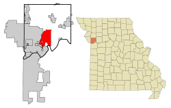 Location in the state of Missouri and in Clay County | |
| Coordinates: 39°14′27″N 94°25′35″W[1] | |
| Country | United States |
| State | Missouri |
| County | Clay |
| Incorporated | May 7, 1829 (as a town),[2] 1851 (as a city)[3] |
| Government | |
| • Type | Mayor-Council-Administrator |
| • Mayor | Lyndell Brenton |
| Area | |
| • Total | 29.15 sq mi (75.50 km2) |
| • Land | 29.03 sq mi (75.19 km2) |
| • Water | 0.12 sq mi (0.31 km2) |
| Elevation | 879 ft (268 m) |
| Population | |
| • Total | 29,149 |
| • Estimate (2019)[6] | 32,100 |
| • Density | 1,000/sq mi (390/km2) |
| [7] | |
| Time zone | UTC−6 (CST) |
| • Summer (DST) | UTC−5 (CDT) |
| ZIP codes | 64068, 64069 |
| Area code(s) | 816 |
| FIPS code | 29-42032[8] |
| GNIS feature ID | 0730132[1] |
| Website | www |
History

Liberty was settled in 1822, and shortly later became the county seat of Clay County.[10] The city was named for the American concept of liberty.[11]
In 1830, David Rice Atchison established a law office in Liberty. He was joined three years later by colleague Alexander William Doniphan. The two argued cases defending the rights of Mormon settlers in Jackson County, served Northwest Missouri in Missouri's General Assembly, and labored for the addition of the Platte Purchase to Missouri's boundaries.
In October 1838, the two were ordered by Governor Lilburn Boggs to arrest Mormon prophet Joseph Smith Jr. at the Far West settlement in Caldwell County.[12] Immediately after the conclusion of the Mormon War, Smith and other Mormon leaders were incarcerated at the Liberty Jail for the winter as Doniphan labored for a quicker trial date. Although Doniphan led a force of Missouri volunteers ordered to capture the leaders, he defended Joseph Smith in trial and won him a change in venue. While en route to their new venue, Smith and his followers escaped and left Missouri for the new Mormon settlement in Nauvoo, Illinois.[12]
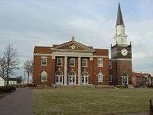
The Arthur-Leonard Historic District, Clay County Savings Association Building, Clinton House, Dougherty-Prospect Heights Historic District, Garrison School Historic District, Frank Hughes Memorial Library, IOOF Liberty Lodge No. 49, Jewell Hall, Jewell-Lightburne Historic District, Major Hotel, Miller Building, Mt. Memorial Cemetery, Nebo Hill Archeological Site, Odd Fellows Home District, South Liberty Courthouse Square Historic District, and West Liberty Courthouse Square Historic District are listed on the National Register of Historic Places.[13][14]
Geography
Liberty is located approximately six miles north of the Missouri River along I-35 and Missouri Route 291.[15]
According to the United States Census Bureau, the city has a total area of 29.15 square miles (75.50 km2), of which 29.03 square miles (75.19 km2) is land and 0.12 square miles (0.31 km2) is water.[4]
Demographics
| Historical population | |||
|---|---|---|---|
| Census | Pop. | %± | |
| 1850 | 827 | — | |
| 1860 | 1,288 | 55.7% | |
| 1870 | 1,700 | 32.0% | |
| 1880 | 1,476 | −13.2% | |
| 1890 | 2,558 | 73.3% | |
| 1900 | 2,407 | −5.9% | |
| 1910 | 2,980 | 23.8% | |
| 1920 | 3,097 | 3.9% | |
| 1930 | 3,516 | 13.5% | |
| 1940 | 3,598 | 2.3% | |
| 1950 | 4,709 | 30.9% | |
| 1960 | 8,909 | 89.2% | |
| 1970 | 13,704 | 53.8% | |
| 1980 | 16,251 | 18.6% | |
| 1990 | 20,459 | 25.9% | |
| 2000 | 26,232 | 28.2% | |
| 2010 | 29,149 | 11.1% | |
| Est. 2019 | 32,100 | [7] | 10.1% |
| U.S. Decennial Census[16] | |||
2010 census
As of the census[5] of 2010, there were 29,149 people, 10,582 households, and 7,555 families living in the city. The population density was 1,004.1 inhabitants per square mile (387.7/km2). There were 11,284 housing units at an average density of 388.7 per square mile (150.1/km2). The racial makeup of the city was 91.4% White, 3.6% African American, 0.5% Native American, 1.0% Asian, 0.1% Pacific Islander, 0.9% from other races, and 2.6% from two or more races. Hispanic or Latino of any race were 4.1% of the population.
There were 10,582 households of which 38.2% had children under the age of 18 living with them, 56.4% were married couples living together, 11.0% had a female householder with no husband present, 4.0% had a male householder with no wife present, and 28.6% were non-families. 23.4% of all households were made up of individuals and 8% had someone living alone who was 65 years of age or older. The average household size was 2.63 and the average family size was 3.11.
The median age in the city was 36.4 years. 26.6% of residents were under the age of 18; 9.8% were between the ages of 18 and 24; 26% were from 25 to 44; 26.5% were from 45 to 64; and 11.1% were 65 years of age or older. The gender makeup of the city was 48.7% male and 51.3% female.
2000 census
As of the census[8] of 2000, there were 26,232 people, 9,511 households, and 6,943 families living in the city. The population density was 973.3 people per square mile (375.8/km²). There were 9,973 housing units at an average density of 370.0 per square mile (142.9/km²). The racial makeup of the city was 93.75% White, 2.59% African American, 0.40% Native American, 0.61% Asian, 0.06% Pacific Islander, 0.99% from other races, and 1.59% from two or more races. Hispanic or Latino of any race were 2.68% of the population.
There were 9,511 households out of which 38.9% had children under the age of 18 living with them, 59.2% were married couples living together, 10.9% had a female householder with no husband present, and 27.0% were non-families. 22.4% of all households were made up of individuals and 7.9% had someone living alone who was 65 years of age or older. The average household size was 2.62 and the average family size was 3.08.
In the city the population was spread out with 27.6% under the age of 18, 10.4% from 18 to 24, 30.2% from 25 to 44, 21.5% from 45 to 64, and 10.4% who were 65 years of age or older. The median age was 34 years. For every 100 females, there were 91.9 males. For every 100 females age 18 and over, there were 89.6 males.
The median income for a household in the city was $52,745, and the median income for a family was $61,273. Males had a median income of $41,713 versus $28,516 for females. The per capita income for the city was $23,415. About 3.8% of families and 5.0% of the population were below the poverty line, including 5.1% of those under age 18 and 6.1% of those age 65 or over.
Economy
Major employers in Liberty include the Hallmark distribution warehouse. Liberty is also home to the operations headquarters for Ferrellgas, the 2nd largest retail provider of propane in the United States. The B&B Theatres corporate office is located in Liberty, the 7th largest theater chain in the U.S.
Top employers
According to the town's 2016 Comprehensive Annual Financial Report,[17] the top employers in the city are:
| # | Employer | # of Employees |
|---|---|---|
| 1 | Liberty School District | 2,109 |
| 2 | Liberty Hospital | 1,400 |
| 3 | Hallmark Cards | 820 |
| 4 | RR Donnelley | 350 |
| 5 | Clay County | 350 |
| 6 | City of Liberty | 325 |
| 7 | Ferrellgas | 263 |
| 8 | Ford Stamping Plant | 256 |
| 9 | William Jewell | 235 |
| 10 | LMV | 185 |
Education
The Liberty 53 School District operates ten elementary, four middle and two senior high schools.[18]
Liberty has a public library, a branch of the Mid-Continent Public Library.[19]
Liberty is also home to William Jewell College, a private, four-year liberal arts college of more than 900 undergraduate students that was founded in 1849.[20]
Notable people
- David Allen, former American football running back for the Jacksonville Jaguars and St. Louis Rams.
- Ken Boyer, former third baseman and coach of the St. Louis Cardinals.
- James Dewees, keyboardist and back-up vocalist of The Get Up Kids, and started Reggie and the Full Effect.
- Alexander William Doniphan, Mexican War general who prevented the execution of the Mormon prophet Joseph Smith.
- Hubert Eaton, visionary and developer of the world-famous Forest Lawn cemeteries in California.
- Shea Groom, soccer player[21]
- Gatewood Lincoln, governor of American Samoa.
- George Rice, football player
- Alex Saxon, actor (The Fosters, Finding Carter)[22]
- Craig Stevens, star of the 1950s television series Peter Gunn.
- Matt Wertz, soft rock singer/songwriter.
- Greg Canuteson, former mayor and state representative[23]
- Scott Carroll, Former Professional Baseball Player.
- Nick Robinson, Former Stanford Basketball player and College Basketball coach.[24]
- Eric Staves, Actor Goat (2016 film), Empire (2015 TV series) and American Horror Story: 1984[25]
- Zac Saleski, Football Coach
Cultural references
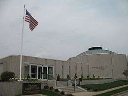
The Liberty Jail is now an open museum and tourist site. The Clay County Historical Society Museum features period room displays, a historic pharmacy counter, toys and dolls, model trains, tools and more.
Twin towns

References
- "Liberty". Geographic Names Information System. United States Geological Survey.
- "History of Liberty | the City of Liberty Official Website!".
- http://libertymissouri.gov/DocumentCenter/Home/View/2356
- "US Gazetteer files 2010". United States Census Bureau. Archived from the original on January 12, 2012. Retrieved 2012-07-08.
- "U.S. Census website". United States Census Bureau. Retrieved 2012-07-08.
- "Population and Housing Unit Estimates". Retrieved June 9, 2017.
- "Population and Housing Unit Estimates". Retrieved May 21, 2020.
- "U.S. Census website". United States Census Bureau. Retrieved 2008-01-31.
- "Find a County". National Association of Counties. Archived from the original on May 31, 2011. Retrieved 2011-06-07.
- Eaton, David Wolfe (1916). How Missouri Counties, Towns and Streams Were Named. The State Historical Society of Missouri. pp. 277.
- "Clay County Place Names, 1928–1945 (archived)". The State Historical Society of Missouri. Archived from the original on 24 June 2016. Retrieved 19 September 2016.CS1 maint: BOT: original-url status unknown (link)
- Muench, James F. (2006). Five Stars: Missouri's Most Famous Generals. Columbia, Missouri: University of Missouri Press. pp. 7–17. ISBN 978-0-8262-1656-4.
- "National Register Information System". National Register of Historic Places. National Park Service. July 9, 2010.
- "National Register of Historic Places Listings". Weekly List of Actions Taken on Properties: 4/23/12 through 4/27/12. National Park Service. 2012-05-04.
- Missouri Atlas & Gazetteer, DeLorme, 1998, First edition, p. 27, ISBN 0-89933-224-2
- "Census of Population and Housing". Census.gov. Retrieved June 4, 2015.
- "City of Liberty 2015 Comprehensive Annual Financial Report" (PDF). Retrieved February 27, 2017.
- "Liberty 53 School District". Great Schools. Retrieved 18 March 2018.
- "Locations". Mid-Continent Public Library. Retrieved 17 March 2018.
- "About". William Jewell College. 2018-02-08.
- Lara, Cindy (2017-09-06). "Shea Groom named Player of the Week". VAVEL.com. Retrieved 2018-05-10.
- "Alex Saxon". IMDb. Retrieved 2014-08-09.
- kellie.houx@mycouriertribune.com, Kellie Houx. "Former mayor receives Civic Leadership Award". Courier-Tribune. Retrieved 2017-10-02.
- https://en.wikipedia.org/wiki/Nick_Robinson_(basketball). Missing or empty
|title=(help) - https://www.imdb.com/name/nm3621352/. Missing or empty
|title=(help)
External links
| Wikimedia Commons has media related to Liberty, Missouri. |
- City of Liberty
- Liberty Area Economic Development
- Historic maps of Liberty in the Sanborn Maps of Missouri Collection at the University of Missouri
Municipalities and communities of Clay County, Missouri, United States | ||
|---|---|---|
| Cities |  Map of Missouri highlighting Clay County | |
| Villages | ||
| Townships | ||
| Unincorporated communities | ||
| Footnotes | ‡This populated place also has portions in an adjacent county or counties | |
Kansas City metropolitan area's cities and counties | ||
|---|---|---|
| Central city |  | |
| Largest cities (over 100,000 in 2000) | ||
| Medium-sized cities (10,000 to 100,000 in 2000) | ||
| Smaller Cities (between 5,000 and 9,900 in 2010) | ||
| Counties | ||