Lebanon, Missouri
Lebanon is a city in Laclede County, Missouri, United States. The population was 14,474 at the 2010 census.[7] It is the county seat of Laclede County.[8] The Lebanon Micropolitan Statistical Area consists of Laclede County.
Lebanon, Missouri | |
|---|---|
 Lebanon Train Depot in 1873 | |
| Motto(s): "Friendly People. Friendly Place." | |
 Location of Lebanon, Missouri | |
| Coordinates: 37°40′42″N 92°39′42″W | |
| Country | United States |
| State | Missouri |
| County | Laclede |
| Incorporated | 1877 |
| Government | |
| • Type | Mayor-Council-City Administrator |
| • Mayor | Jared Carr |
| Area | |
| • Total | 14.72 sq mi (38.12 km2) |
| • Land | 14.63 sq mi (37.89 km2) |
| • Water | 0.09 sq mi (0.23 km2) |
| Elevation | 1,265 ft (386 m) |
| Population | |
| • Total | 14,474 |
| • Estimate (2019)[4] | 14,798 |
| • Density | 980/sq mi (380/km2) |
| Time zone | UTC-6 (Central (CST)) |
| • Summer (DST) | UTC-5 (CDT) |
| ZIP code | 65536 |
| Area code(s) | 417 |
| FIPS code | 29-41168[5] |
| GNIS feature ID | 0720871[6] |
| Website | www |
History
Lebanon was founded in 1849.[9] The community was named after Lebanon, Tennessee, the former home of many of the first settlers.[10][11] Lebanon also had many motels, for travelers along Route 66 to stay in.
The Ralph E. Burley House, Joe Knight Building, Laclede County Jail, Ploger-Moneymaker Place, and Wallace House are listed on the National Register of Historic Places.[12]
Geography
Lebanon is located at 37°40′42″N 92°39′42″W (37.678203, -92.661694).[13] According to the United States Census Bureau, the city has a total area of 14.72 square miles (38.12 km2), of which 14.63 square miles (37.89 km2) is land and 0.09 square miles (0.23 km2) is water.[1]
Demographics
| Historical population | |||
|---|---|---|---|
| Census | Pop. | %± | |
| 1860 | 341 | — | |
| 1870 | 1,090 | 219.6% | |
| 1880 | 1,419 | 30.2% | |
| 1890 | 2,218 | 56.3% | |
| 1900 | 2,125 | −4.2% | |
| 1910 | 2,430 | 14.4% | |
| 1920 | 2,848 | 17.2% | |
| 1930 | 3,562 | 25.1% | |
| 1940 | 5,025 | 41.1% | |
| 1950 | 6,808 | 35.5% | |
| 1960 | 8,220 | 20.7% | |
| 1970 | 8,616 | 4.8% | |
| 1980 | 9,507 | 10.3% | |
| 1990 | 9,983 | 5.0% | |
| 2000 | 12,155 | 21.8% | |
| 2010 | 14,474 | 19.1% | |
| Est. 2019 | 14,798 | [4] | 2.2% |
| U.S. Decennial Census[14] | |||
2010 census
As of the census[3] of 2010, there were 14,474 people, 5,980 households, and 3,745 families living in the city. The population density was 989.3 inhabitants per square mile (382.0/km2). There were 6,728 housing units at an average density of 459.9 per square mile (177.6/km2). The racial makeup of the city was 94.1% White, 1.3% African American, 0.6% Native American, 0.7% Asian, 0.1% Pacific Islander, 0.7% from other races, and 2.4% from two or more races. Hispanic or Latino of any race were 2.6% of the population.
There were 5,980 households of which 34.0% had children under the age of 18 living with them, 43.6% were married couples living together, 13.7% had a female householder with no husband present, 5.3% had a male householder with no wife present, and 37.4% were non-families. 31.8% of all households were made up of individuals and 14.3% had someone living alone who was 65 years of age or older. The average household size was 2.36 and the average family size was 2.94.
The median age in the city was 35.4 years. 25.9% of residents were under the age of 18; 9.7% were between the ages of 18 and 24; 25.9% were from 25 to 44; 22.5% were from 45 to 64; and 15.8% were 65 years of age or older. The gender makeup of the city was 47.5% male and 52.5% female.
2000 census
As of the census[5] of 2000, there were 12,155 people, 5,132 households, and 3,181 families living in the city. The population density was 891.9 people per square mile (344.3/km²). There were 5,745 housing units at an average density of 421.6 per square mile (162.7/km²). The racial makeup of the city was 95.99% White, 0.90% African American, 0.54% Native American, 0.50% Asian, 0.03% Pacific Islander, 0.42% from other races, and 1.61% from two or more races. Hispanic or Latino of any race were 1.65% of the population.
There were 5,132 households out of which 30.6% had children under the age of 18 living with them, 45.8% were married couples living together, 12.3% had a female householder with no husband present, and 38.0% were non-families. 33.4% of all households were made up of individuals and 16.6% had someone living alone who was 65 years of age or older. The average household size was 2.30 and the average family size was 2.91.
In the city, the population was spread out with 25.2% under the age of 18, 10.1% from 18 to 24, 27.4% from 25 to 44, 19.5% from 45 to 64, and 17.9% who were 65 years of age or older. The median age was 36 years. For every 100 females, there were 88.2 males. For every 100 females age 18 and over, there were 82.9 males.
The median income for a household in the city was $27,668, and the median income for a family was $36,509. Males had a median income of $27,657 versus $17,509 for females. The per capita income for the city was $16,636. About 12.3% of families and 15.2% of the population were below the poverty line, including 17.4% of those under age 18 and 18.0% of those age 65 or over.
Education
Public education in Lebanon is administered by Lebanon R-III School District, which operates Lebanon High School.[15]
Lebanon has a public library, the Lebanon-Laclede County Library.[16]
Notable people
Famous residents past and present include:
- Richard P. Bland, congressman from the state of Missouri.
- Jim Bohannon, nationally syndicated radio news and talk show host; raised in Lebanon and got his first radio job at the local station.
- Justin Britt, offensive lineman for Seattle Seahawks; star at Lebanon High School before college career at Mizzou.
- Phil M. Donnelly, 41st and 43rd governor of Missouri.
- Michael S. Hopkins, NASA astronaut and Air Force colonel;[17] born in Lebanon, grew up near Richland.
- Antoine Predock, architect and designer.
- Jerry Schoonmaker, professional baseball player for the Washington Senators.
- William Tecumseh Vernon, Register of the Treasury from 1906 to 1911; also the president of Western University starting in 1896.
- Betty Wagoner, professional baseball player for the South Bend Blue Sox.
- Lanford Wilson, playwright and winner of the Pulitzer Prize for drama.
- Harold Bell Wright, author whose book The Calling of Dan Matthews is about his time in Lebanon.
See also
References
- "US Gazetteer files 2010". United States Census Bureau. Archived from the original on 2012-07-02. Retrieved 2012-07-08.
- City-data.com
- "U.S. Census website". United States Census Bureau. Retrieved 2012-07-08.
- "Population and Housing Unit Estimates". Retrieved May 21, 2020.
- "U.S. Census website". United States Census Bureau. Retrieved 2008-01-31.
- "US Board on Geographic Names". United States Geological Survey. 2007-10-25. Retrieved 2008-01-31.
- "Profile of General Population and Housing Characteristics: 2010 Demographic Profile Data (DP-1): Lebanon city, Missouri". United States Census Bureau. Retrieved March 5, 2012.
- "Find a County". National Association of Counties. Retrieved 2011-06-07.
- "Post Offices". Jim Forte Postal History. Retrieved 24 October 2016.
- "Laclede County Place Names, 1928–1945 (archived)". The State Historical Society of Missouri. Archived from the original on 24 June 2016. Retrieved 24 October 2016.CS1 maint: BOT: original-url status unknown (link)
- Eaton, David Wolfe (1916). How Missouri Counties, Towns and Streams Were Named. The State Historical Society of Missouri. pp. 182.
- "National Register Information System". National Register of Historic Places. National Park Service. July 9, 2010.
- "US Gazetteer files: 2010, 2000, and 1990". United States Census Bureau. 2011-02-12. Retrieved 2011-04-23.
- "Census of Population and Housing". Census.gov. Retrieved June 4, 2015.
- "Lebanon R-Iii School District". Great Schools. Retrieved 4 June 2019.
- "Missouri Public Libraries". PublicLibraries.com. Archived from the original on 10 June 2017. Retrieved 2 June 2019.
- "Astronaut Bio". www.jsc.nasa.gov. NASA JSC. Retrieved 6 June 2014.
External links
- City of Lebanon
- Lebanon Area Chamber of Commerce
- Historic maps of Lebanon in the Sanborn Maps of Missouri Collection at the University of Missouri
Municipalities and communities of Laclede County, Missouri, United States | ||
|---|---|---|
| Cities | 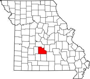 Map of Missouri highlighting Laclede County | |
| Villages | ||
| Townships |
| |
| CDP | ||
| Other unincorporated communities | ||
| Ghost towns | ||
| Footnotes | ‡This populated place also has portions in an adjacent county or counties | |
| Authority control |
|
|---|