Scotland County, Missouri
Scotland County is located in the northeastern portion of the U.S. state of Missouri. As of the 2010 census, the population was 4,843,[1] making it the fifth-least populous county in Missouri. Its county seat is Memphis.[2] The county was organized January 29, 1841, and named for Scotland.
Scotland County | |
|---|---|
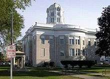
 Scotland County court house in Memphis | |
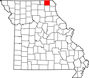 Location within the U.S. state of Missouri | |
 Missouri's location within the U.S. | |
| Coordinates: 40°27′N 92°09′W | |
| Country | |
| State | |
| Founded | January 29, 1841 |
| Named for | Scotland |
| Seat | Memphis |
| Largest city | Memphis |
| Area | |
| • Total | 439 sq mi (1,140 km2) |
| • Land | 437 sq mi (1,130 km2) |
| • Water | 2.6 sq mi (7 km2) 0.6% |
| Population (2010) | |
| • Total | 4,843 |
| • Estimate (2018) | 4,966 |
| • Density | 11/sq mi (4.3/km2) |
| Time zone | UTC−6 (Central) |
| • Summer (DST) | UTC−5 (CDT) |
| Congressional district | 6th |
| Website | www |
History
Scotland County was organized by an act of the Missouri General Assembly on January 29, 1841. At first its boundaries contained all the land now known as Knox County as well, but another act by the General Assembly in 1843 divided it off.[3] Stephen W. B. Carnegy suggested that the county be named after his native country of Scotland.[4] He also gave several settlements in the area Scottish names.
The first white settlement in Scotland County was in 1833 by brothers Levi and George Rhodes and their families near a location known as "Sand Hill".[3] Sand Hill was in the southern part of the county, about twelve miles from present-day Memphis. A general store was opened there around 1835 by James l. Jones, who also served as Scotland County's first sheriff.
Slavery, while never as prevalent in Scotland County as in others further south in the state's Little Dixie region, did exist from the county's earliest days. Robert T. Smith brought the first slaves, a group of three, to the county in 1834.[3] In 1850 Scotland County had 157 slaves or other "non-free people of color". However, by the 1860 census that number was reduced to 131.[3]
Farming was the primary economic lifeblood of Scotland County from its earliest times. Once the stands of timber were cleared and the tough prairie grass was plowed aside, settlers found rich soil. Between 1850 and 1880 the number of farms in the county grew from 334 to 1,994. The value of the farmland, in 1880 dollars, was over $3.72 million.[3] Corn was the major cash crop, followed by oats, wheat, and potatoes.
The Civil War
Scotland County was the scene of three notable engagements during the American Civil War. The first happened at Etna on July 21, 1861. The 1st Northeast Missouri Home Guards under Colonel David Moore with assistance of additional units from Iowa and Illinois attacked pro-Confederate Missouri State Guard (MSG) forces using Etna as a training and resupply point. The action was part of General Nathaniel Lyon's efforts to clear "rebels" from rural Missouri. After a brief battle the MSG forces, mostly lightly-armed cavalry, were driven from the town and surrounding areas of Scotland County and Moore's unit returned to its main base at Athens, Missouri.
On July 13, 1862 Confederate Colonel Joseph C. Porter approached Memphis, Missouri in four converging columns totalling 125–169 men and captured it with little or no resistance.[5] They first raided the Federal armory, seizing about a hundred muskets with cartridge boxes and ammunition, and several uniforms. The Confederate rounded up all adult males, who were taken to the court house to swear not to divulge any information about the raiders for forty-eight hours. Porter freed all militiamen and suspected militiamen to await parole, a fact noted by champions of his character. Citizens expressed their sympathies variously; Porter gave safe passage to a physician, an admitted supporter of the Union, who was anxious to return to his seriously ill wife. A verbally abusive woman was threatened with a pistol by one of Porter's troops, perhaps as a bluff. Porter's troops entered the courthouse and destroyed all indictments for horse theft; the act is variously understood as simple lawlessness, intervention on behalf of criminal associates, or interference with politically motivated, fraudulent charges.[5]
At Memphis, a key incident occurred which would darken Colonel Porter's reputation, and which his detractors see as part of a consistent behavioral pattern which put him and his men beyond the norms of warfare. According to the "History of Shelby County,” which is generally sympathetic to Porter, “Most conceded that Col. Porter’s purpose for capturing Memphis, MO. was to seize Dr. Wm. Aylward, a prominent Union man of the community.” Aylward was captured during the day by Captain Tom Stacy's men and confined to a house. Stacy was generally regarded as a genuine bushwhacker, with his company called "the chain gang" by the other members of Porter's command due to their behavior. After rousing Doctor Aylward overnight and removing him from his home, ostensibly to see Porter, guards claimed that he escaped. However, witnesses reported hearing the sounds of a strangling, and his body was found the next day, with marks consistent with hanging or strangulation.[5] Supporters of Porter attribute the murder of Aylward to Stacy. However, a Union gentleman who came to inquire about Aylward and a captured officer before the discovery of the body stated that when he asked Porter about Aylward, the response was, "He is where he will never disturb anybody else."[5]
The next engagement in the county took place on July 18, 1862. Union Colonel (later General) John McNeil had been pursuing Porter and his forces across northeast Missouri for some time. When hearing of the capture of Memphis, McNeil sent a detachment of three companies (C, H, and I), about three hundred men, of Merrill's Horse under Major John Y. Clopper from Newark, Missouri to rescue the town.[6] Colonel Porter and his Confederate forces, their strength estimated at anywhere between one hundred twenty-five men[5] to upwards of six hundred, planned to ambush the Federals. This would become known as the "Battle of Vassar Hill" in the History of Scotland County. Porter himself called it “Oak Ridge,” and Federal forces called it “Pierce’s Mill". By whatever name, it happened approximately ten miles southwest of Memphis on the south fork of the Middle Fabius River.
Porter's men were concealed in brush and stayed low when the Federals stopped to fire prior to each charge. Porter's men held their fire until the range was very short, increasing the lethality of the volley.[5] Clopper was in the Federal front, and out of 21 men of his advance guard, all but one were killed or wounded.[7] The Federals made at least seven mounted charges doing little but adding to the body count. A battalion of roughly 100 men [6] of the 11th Missouri State Militia Cavalry under Major Rogers arrived and dismounted. While Clopper claimed to have driven the enemy from the field after this, eyewitness Dr. Joseph Mudd said that the Union troops instead fell back and ended the engagement leaving Porter in possession of the field until he withdrew. Clopper's reputation suffered as a result of his poor tactics. Before the final charge one company officer angrily asked, "Why don't you dismount those men and stop murdering them?" [8] Union casualties were about 24 killed and mortally wounded (10 from Merrill's Horse and 14 from the 11th MSM Cavalry), and perhaps 59 wounded (24 from Merrill's Horse, and 35 from the 11th MSM Cavalry.) Porter's loss was as little as three killed and five wounded according to Mudd, or six killed, three mortally wounded, and 10 wounded left on the field according to the Shelby County History.[7]
Post-war to present
In the 1880s, a group called The Tax-payers' Association of Scotland County formed to resist paying local taxes and to intimidate any potential bidders on horses and mules that had been seized to cover those taxes. The handling of county debt collection went to the Supreme Court in Findlay v. McAllister.
Geography
According to the U.S. Census Bureau, the county has a total area of 439 square miles (1,140 km2), of which 437 square miles (1,130 km2) is land and 2.6 square miles (6.7 km2) (0.6%) is water.[9] Scotland County borders Iowa to the north.
Adjacent counties
- Davis County, Iowa (northwest)
- Van Buren County, Iowa (northeast)
- Clark County (east)
- Knox County (south)
- Adair County (southwest)
- Schuyler County (west)
Major highways


Demographics
| Historical population | |||
|---|---|---|---|
| Census | Pop. | %± | |
| 1850 | 3,782 | — | |
| 1860 | 8,873 | 134.6% | |
| 1870 | 10,670 | 20.3% | |
| 1880 | 12,508 | 17.2% | |
| 1890 | 12,674 | 1.3% | |
| 1900 | 13,232 | 4.4% | |
| 1910 | 11,869 | −10.3% | |
| 1920 | 10,700 | −9.8% | |
| 1930 | 8,853 | −17.3% | |
| 1940 | 8,557 | −3.3% | |
| 1950 | 7,332 | −14.3% | |
| 1960 | 6,484 | −11.6% | |
| 1970 | 5,499 | −15.2% | |
| 1980 | 5,415 | −1.5% | |
| 1990 | 4,822 | −11.0% | |
| 2000 | 4,983 | 3.3% | |
| 2010 | 4,843 | −2.8% | |
| Est. 2018 | 4,966 | [10] | 2.5% |
| U.S. Decennial Census[11] 1790-1960[12] 1900-1990[13] 1990-2000[14] 2010-2015[1] | |||
As of the census[15] of 2010, there were 4,843 people, 1,902 households, and 1,302 families residing in the county. The population density was 11 people per square mile (4/km²). There were 2,292 housing units at an average density of 5 per square mile (2/km²). The racial makeup of the county was 98.82% White, 0.20% Black or African American, 0.14% Native American, 0.08% Asian, 0.02% Pacific Islander, 0.16% from other races, and 0.58% from two or more races. Approximately 0.84% of the population were Hispanic or Latino of any race. In the county, 5.72% report speaking Pennsylvania German, Dutch, or German at home, while 1.58% speak Spanish.[16]
There were 1,902 households out of which 32.40% had children under the age of 18 living with them, 58.20% were married couples living together, 7.00% had a female householder with no husband present, and 31.50% were non-families. 28.20% of all households were made up of individuals and 15.30% had someone living alone who was 65 years of age or older. The average household size was 2.55 and the average family size was 3.16.
In the county, the population was spread out with 28.60% under the age of 18, 7.60% from 18 to 24, 24.10% from 25 to 44, 20.80% from 45 to 64, and 19.00% who were 65 years of age or older. The median age was 37 years. For every 100 females there were 94.30 males. For every 100 females age 18 and over, there were 87.80 males.
The median income for a household in the county was $27,409, and the median income for a family was $33,529. Males had a median income of $23,836 versus $16,866 for females. The per capita income for the county was $14,474. About 13.40% of families and 16.80% of the population were below the poverty line, including 21.70% of those under age 18 and 13.50% of those age 65 or over.
Education
Public schools
- Scotland County R-I School District – Memphis
- Scotland County Elementary School (PK-06)
- Scotland County High School (07-12)
Public libraries
- Scotland County Memorial Library[17]
Politics
Local
The Democratic Party controls politics at the local level in Scotland County. Democrats hold all but five of the elected positions in the county.
| Scotland County, Missouri | ||||
|---|---|---|---|---|
| Elected countywide officials | ||||
| Assessor | James Ward | Republican | ||
| Circuit Clerk | Anita Watkins | Democratic | ||
| County Clerk | Batina Dodge | Democratic | ||
| Collector | Kathy Becraft | {{{collectorparty}}} | ||
| Commissioner (Presiding) |
Duane Ebeling | Republican | ||
| Commissioner (District 1) |
Danette Clatt | Republican | ||
| Commissioner (District 2) |
David Wiggins | Republican | ||
| Coroner | Dr. Jeff Davis | Republican | ||
| Prosecuting Attorney | Kimberly J. Nicoli | Democratic | ||
| Public Administrator | Patty Freeburg | Democratic | ||
| Recorder | Dana Glasscock | Democratic | ||
| Sheriff | Wayne Winn | Republican | ||
| Surveyor | Robert Revere | Democratic | ||
| Treasurer | Kathy Kiddoo | Republican | ||
State
| Year | Republican | Democratic | Third Parties |
|---|---|---|---|
| 2016 | 65.32% 1,273 | 31.30% 610 | 3.38% 66 |
| 2012 | 48.61% 930 | 48.14% 921 | 3.24% 62 |
| 2008 | 57.14% 1,197 | 40.91% 857 | 1.96% 41 |
| 2004 | 70.16% 1,507 | 28.63% 615 | 1.22% 26 |
| 2000 | 53.00% 1,129 | 45.16% 962 | 1.84% 39 |
| 1996 | 24.62% 499 | 72.52% 1,470 | 2.86% 58 |
All of Scotland County is included in Missouri's 4th District in the Missouri House of Representatives and is represented by Craig Redmon (R-Canton).
| Party | Candidate | Votes | % | ± | |
|---|---|---|---|---|---|
| Republican | Craig Redmon | 1,677 | 100.00% | ||
| Party | Candidate | Votes | % | ± | |
|---|---|---|---|---|---|
| Republican | Craig Redmon | 1,276 | 100.00% | ||
| Party | Candidate | Votes | % | ± | |
|---|---|---|---|---|---|
| Republican | Craig Redmon | 1,595 | 100.00% | ||
All of Scotland County is a part of Missouri's 18th District in the Missouri Senate and is currently represented by Brian Munzlinger (R-Williamstown).
| Party | Candidate | Votes | % | ± | |
|---|---|---|---|---|---|
| Republican | Brian Munzlinger | 1,244 | 100.00% | ||
Federal
| Party | Candidate | Votes | % | ± | |
|---|---|---|---|---|---|
| Republican | Roy Blunt | 1,283 | 66.13% | +19.13 | |
| Democratic | Jason Kander | 570 | 29.38% | -19.76 | |
| Libertarian | Jonathan Dine | 39 | 2.01% | -1.85 | |
| Green | Johnathan McFarland | 18 | 0.93% | +0.93 | |
| Constitution | Fred Ryman | 30 | 1.55% | +1.55 | |
| Party | Candidate | Votes | % | ± | |
|---|---|---|---|---|---|
| Republican | Todd Akin | 900 | 47.00% | ||
| Democratic | Claire McCaskill | 941 | 49.14% | ||
| Libertarian | Jonathan Dine | 74 | 3.86% | ||
All of Scotland County is included in Missouri's 6th Congressional District and is currently represented by Sam Graves (R-Tarkio) in the U.S. House of Representatives.
| Party | Candidate | Votes | % | ± | |
|---|---|---|---|---|---|
| Republican | Sam Graves | 1,509 | 79.01% | +4.20 | |
| Democratic | David M. Blackwell | 333 | 17.43% | -5.15 | |
| Libertarian | Russ Lee Monchil | 29 | 1.52% | -1.09 | |
| Green | Mike Diel | 39 | 2.04% | +2.04 | |
| Party | Candidate | Votes | % | ± | |
|---|---|---|---|---|---|
| Republican | Sam Graves | 1,090 | 74.81% | +5.27 | |
| Democratic | Bill Hedge | 329 | 22.58% | -5.46 | |
| Libertarian | Russ Lee Monchil | 38 | 2.61% | +0.19 | |
| Party | Candidate | Votes | % | ± | |
|---|---|---|---|---|---|
| Republican | Sam Graves | 1,265 | 69.54% | ||
| Democratic | Kyle Yarber | 510 | 28.04% | ||
| Libertarian | Russ Monchil | 44 | 2.42% | ||
| Year | Republican | Democratic | Third parties |
|---|---|---|---|
| 2016 | 77.0% 1,525 | 18.4% 365 | 4.6% 91 |
| 2012 | 64.4% 1,246 | 33.2% 643 | 2.4% 47 |
| 2008 | 59.5% 1,249 | 37.8% 793 | 2.7% 56 |
| 2004 | 61.5% 1,352 | 37.7% 828 | 0.8% 17 |
| 2000 | 61.3% 1,335 | 36.3% 790 | 2.5% 54 |
| 1996 | 36.7% 773 | 47.0% 990 | 16.3% 343 |
| 1992 | 32.0% 798 | 42.9% 1,070 | 25.1% 626 |
| 1988 | 52.6% 1,248 | 47.1% 1,117 | 0.3% 7 |
| 1984 | 58.0% 1,485 | 42.0% 1,075 | |
| 1980 | 55.5% 1,592 | 41.8% 1,200 | 2.7% 77 |
| 1976 | 46.7% 1,286 | 52.7% 1,449 | 0.6% 17 |
| 1972 | 60.2% 1,918 | 39.8% 1,269 | |
| 1968 | 50.1% 1,554 | 43.2% 1,340 | 6.8% 210 |
| 1964 | 35.7% 1,215 | 64.3% 2,187 | |
| 1960 | 50.2% 1,899 | 49.8% 1,884 | |
| 1956 | 45.9% 1,735 | 54.1% 2,044 | |
| 1952 | 50.2% 2,123 | 49.5% 2,093 | 0.2% 10 |
| 1948 | 40.8% 1,693 | 59.0% 2,451 | 0.2% 9 |
| 1944 | 48.7% 2,058 | 51.1% 2,158 | 0.1% 6 |
| 1940 | 48.7% 2,329 | 50.9% 2,435 | 0.5% 23 |
| 1936 | 40.7% 1,940 | 58.0% 2,768 | 1.3% 64 |
| 1932 | 33.5% 1,410 | 65.1% 2,738 | 1.4% 57 |
| 1928 | 51.5% 2,350 | 48.1% 2,194 | 0.5% 22 |
| 1924 | 44.8% 2,282 | 51.0% 2,595 | 4.2% 215 |
| 1920 | 53.1% 2,509 | 45.0% 2,124 | 1.9% 91 |
| 1916 | 42.9% 1,243 | 54.9% 1,592 | 2.2% 65 |
| 1912 | 30.1% 860 | 53.3% 1,525 | 16.6% 474 |
| 1908 | 43.9% 1,273 | 54.0% 1,564 | 2.1% 60 |
| 1904 | 45.5% 1,354 | 51.5% 1,530 | 3.0% 89 |
| 1900 | 40.8% 1,277 | 56.3% 1,760 | 2.9% 90 |
| 1896 | 36.5% 1,203 | 63.0% 2,077 | 0.6% 19 |
| 1892 | 33.3% 940 | 48.5% 1,369 | 18.2% 515 |
| 1888 | 41.7% 1,226 | 57.2% 1,680 | 1.1% 33 |
Missouri presidential preference primary (2008)
| Scotland County, Missouri | |
|---|---|
| 2008 Republican primary in Missouri | |
| John McCain | 129 (29.79%) |
| Mike Huckabee | 185 (42.73%) |
| Mitt Romney | 94 (21.71%) |
| Ron Paul | 16 (3.70%) |
| Scotland County, Missouri | |
|---|---|
| 2008 Democratic primary in Missouri | |
| Hillary Clinton | 322 (54.03%) |
| Barack Obama | 217 (36.41%) |
| John Edwards (withdrawn) | 44 (7.38%) |
| Uncommitted | 8 (1.34%) |
Former U.S. Senator Hillary Clinton (D-New York) received more votes, a total of 322, than any candidate from either party in Scotland County during the 2008 presidential primary.
Notable people
- Ella Ewing - World's tallest woman (in her era), lived much of her life (and died) near Gorin. She now rests in the Harmony Grove church cemetery in Rutledge, MO.
- Alexandre Hogue, Realist painter, known mostly for landscapes.
- Tom Horn - American Old West lawman, scout, outlaw and assassin, born near Granger in 1860.
- George Saling, gold medal winner at the 1932 Summer Olympics, 110m hurdles.
- Adrienne Wilkinson, TV, film and voiceover actress. Notable roles on Xena: Warrior Princess and As If.
See also
- National Register of Historic Places listings in Scotland County, Missouri
References
- "State & County QuickFacts". United States Census Bureau. Retrieved September 14, 2013.
- "Find a County". National Association of Counties. Retrieved 2011-06-07.
- History of Lewis, Clark, Knox, and Scotland Counties. St. Louis, Chicago: The Goodspeed Publishing Company. 1887. pp. 405–554.
- Eaton, David Wolfe (1918). How Missouri Counties, Towns and Streams Were Named. The State Historical Society of Missouri. p. 362.
- Mudd, Joseph A. (1889). With Porter in North Missouri. Washington, D.C.: The National Publishing Company. pp. 72–90.
- Moore, Frank, The Rebellion Record, Fifth Volume, G.P. Putnam, 1868, page 558, from "The Fight near Memphis, Mo." in the Missouri Democrat
- The History of Shelby Country, page 744
- Banasik, Michael, Embattled Arkansas: The Prairie Grove Campaign of 1862, Broadfoot Publishing, 1998, page 124
- "2010 Census Gazetteer Files". United States Census Bureau. August 22, 2012. Archived from the original on October 21, 2013. Retrieved November 20, 2014.
- "Population and Housing Unit Estimates". Retrieved November 13, 2019.
- "U.S. Decennial Census". United States Census Bureau. Retrieved November 20, 2014.
- "Historical Census Browser". University of Virginia Library. Retrieved November 20, 2014.
- "Population of Counties by Decennial Census: 1900 to 1990". United States Census Bureau. Retrieved November 20, 2014.
- "Census 2000 PHC-T-4. Ranking Tables for Counties: 1990 and 2000" (PDF). United States Census Bureau. Retrieved November 20, 2014.
- "U.S. Census website". United States Census Bureau. Retrieved 2008-01-31.
- Breeding, Marshall. "Scotland County Memorial Library". Libraries.org. Retrieved May 8, 2017.
- Leip, David. "Dave Leip's Atlas of U.S. Presidential Elections". uselectionatlas.org. Retrieved 2018-03-26.
External links
- Rootsweb for Scotland County, Missouri
- Memphis Area Chamber of Commerce
- Digitized 1930 Plat Book of Scotland County from University of Missouri Division of Special Collections, Archives, and Rare Books
Places adjacent to Scotland County, Missouri | ||||||||||
|---|---|---|---|---|---|---|---|---|---|---|
| ||||||||||
Municipalities and communities of Scotland County, Missouri, United States | ||
|---|---|---|
| Cities | Map of Missouri highlighting Scotland County | |
| Villages | ||
| Townships | ||
| Unincorporated communities | ||

| Authority control |
|
|---|