Stoddard County, Missouri
Stoddard County is a county located in the southeastern portion of the U.S. state of Missouri. As of the 2010 census, the population was 29,968.[1] The county seat is Bloomfield.[2] The county was officially organized on January 2, 1835, and is named for Amos Stoddard, the first American commandant (an early term for "governor") of Upper Louisiana.[3]
Stoddard County | |
|---|---|
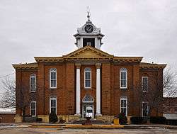 Stoddard County Courthouse, February 2014 | |
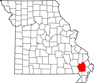 Location within the U.S. state of Missouri | |
 Missouri's location within the U.S. | |
| Coordinates: 36°52′N 89°57′W | |
| Country | |
| State | |
| Founded | January 2, 1835 |
| Named for | Amos Stoddard |
| Seat | Bloomfield |
| Largest city | Dexter |
| Area | |
| • Total | 829 sq mi (2,150 km2) |
| • Land | 823 sq mi (2,130 km2) |
| • Water | 5.8 sq mi (15 km2) 0.7% |
| Population (2010) | |
| • Total | 29,968 |
| • Estimate (2018) | 29,206 |
| • Density | 36/sq mi (14/km2) |
| Time zone | UTC−6 (Central) |
| • Summer (DST) | UTC−5 (CDT) |
| Congressional district | 8th |
Geography
According to the U.S. Census Bureau, the county has a total area of 829 square miles (2,150 km2), of which 823 square miles (2,130 km2) is land and 5.8 square miles (15 km2) (0.7%) is water.[4]
Adjacent counties
- Bollinger County (north)
- Cape Girardeau County (northeast)
- Scott County (northeast)
- New Madrid County (southeast)
- Dunklin County (south)
- Butler County (southwest)
- Wayne County (northwest)
Major highways
.svg.png)


National protected area
Demographics
| Historical population | |||
|---|---|---|---|
| Census | Pop. | %± | |
| 1840 | 3,153 | — | |
| 1850 | 4,277 | 35.6% | |
| 1860 | 7,877 | 84.2% | |
| 1870 | 8,535 | 8.4% | |
| 1880 | 13,431 | 57.4% | |
| 1890 | 17,327 | 29.0% | |
| 1900 | 24,669 | 42.4% | |
| 1910 | 27,807 | 12.7% | |
| 1920 | 29,755 | 7.0% | |
| 1930 | 27,452 | −7.7% | |
| 1940 | 33,009 | 20.2% | |
| 1950 | 33,463 | 1.4% | |
| 1960 | 29,490 | −11.9% | |
| 1970 | 25,771 | −12.6% | |
| 1980 | 29,009 | 12.6% | |
| 1990 | 28,895 | −0.4% | |
| 2000 | 29,705 | 2.8% | |
| 2010 | 29,968 | 0.9% | |
| Est. 2018 | 29,206 | [5] | −2.5% |
| U.S. Decennial Census[6] 1790-1960[7] 1900-1990[8] 1990-2000[9] 2010-2015[1] | |||
As of the census[10] of 2000, there 29,705 people, 12,064 households, and 8,480 families residing in the county. The population density was 36 people per square mile (14/km²). There were 13,221 housing units at an average density of 16 per square mile (6/km²). The racial makeup of the county was 97.34% White, 0.91% Black or African American, 0.40% Native American, 0.09% Asian, 0.01% Pacific Islander, 0.24% from other races, and 1.01% from two or more races. Approximately 0.78% of the population were Hispanic or Latino of any race. 38.4% were of American, 15.4% German, 12.4% Irish and 8.5% English ancestry.
There were 12,064 households out of which 30.50% had children under the age of 18 living with them, 57.40% were married couples living together, 9.40% had a female householder with no husband present, and 29.70% were non-families. 26.60% of all households were made up of individuals and 13.70% had someone living alone who was 65 years of age or older. The average household size was 2.39 and the average family size was 2.88.
In the county, the population was spread out with 23.90% under the age of 18, 8.50% from 18 to 24, 26.30% from 25 to 44, 24.10% from 45 to 64, and 17.20% who were 65 years of age or older. The median age was 39 years. For every 100 females there were 92.60 males. For every 100 females age 18 and over, there were 88.20 males.
The median income for a household in the county was $33,120, and the median income for a family was $41,072. Males had a median income of $26,514 versus $17,778 for females. The per capita income for the county was $18,003. About 12.80% of families and 16.50% of the population were below the poverty line, including 20.20% of those under age 18 and 17.60% of those age 65 or over.
Religion
According to the Association of Religion Data Archives County Membership Report (2000), Stoddard County is a part of the Bible Belt with evangelical Protestantism being the majority religion. The most predominant denominations among residents in Stoddard County who adhere to a religion are Southern Baptists (49.21%), Methodists (12.10%), and Churches of Christ (8.69%).
Politics
Local
The Republican Party predominately controls politics at the local level in Stoddard County. Republicans hold ten of the elected positions in the county. In the 2016 election, Sheriff Carl Hefner, who originally ran as a Democrat, switched parties and ran as a Republican.
| Stoddard County, Missouri | ||||
|---|---|---|---|---|
| Elected countywide officials | ||||
| Assessor | Daniel Creg | Republican | ||
| Circuit Clerk | Paula Yancey | Republican | ||
| County Clerk | Cecil Weeks | Republican | ||
| Commissioner (Presiding) |
Danny Talkington | Republican | ||
| Commissioner (District 1) |
Steve Jordan | Republican | ||
| Commissioner (District 2) |
Carol Jarrell | Republican | ||
| Prosecuting Attorney | Russ Oliver | Republican | ||
| Public Administrator | Cindy Duckworth | Republican | ||
| Recorder | Kay Asbell | Democratic | ||
| Sheriff | Carl Hefner | Republican | ||
| Surveyor | Joseph R Pulliam | Republican | ||
| Treasurer | Carla Moore | Democratic | ||
State
Stoddard County is divided among three legislative districts in the Missouri House of Representatives.
- District 159 – Currently represented by Billy Pat Wright (R-Dexter) and consists of most of the county, including Advance, Bell City, Bloomfield, Dexter, Dudley, and Puxico.
| Party | Candidate | Votes | % | ± | |
|---|---|---|---|---|---|
| Republican | Billy Pat Wright* | 5,999 | 71.33 | +8.70 | |
| Democratic | Bill Burlison | 2,411 | 28.67 | -8.70 | |
- District 161 – Currently represented by Steve Hodges (D-East Prairie) and consists of some of the southeastern portions of the county along the New Madrid County border including Baker, Essex, and Penermon.
| Party | Candidate | Votes | % | ± | |
|---|---|---|---|---|---|
| Republican | Ron McCormick | 257 | 59.49 | +59.49 | |
| Democratic | Steve Hodges* | 175 | 40.51 | -59.49 | |
- District 163 – Currently represented by Kent Hampton (R-Malden) and consists of the southwestern corner along the Dunklin and Butler county lines, including Bernie. Democratic incumbent Tom Todd was defeated by Republican challenger Kent Hampton in 2010.
| Party | Candidate | Votes | % | ± | |
|---|---|---|---|---|---|
| Republican | Kent Hampton | 654 | 63.01 | +63.01 | |
| Democratic | Tom Todd* | 384 | 36.99 | -37.86 | |
All of Stoddard County is a part of Missouri's 25th District in the Missouri Senate and is currently represented by State Senator Rob Mayer (R-Dexter). In 2008, Mayer defeated Democrat M. Shane Stoelting 65.32%-34.68% in the district. The 25th Senatorial District consists of Butler, Dunklin, New Madrid, Pemiscot, Ripley, Stoddard, and Wayne counties.
| Party | Candidate | Votes | % | ± | |
|---|---|---|---|---|---|
| Republican | Rob Mayer | 9,894 | 75.51 | ||
| Democratic | M. Shane Stoelting | 3,209 | 24.49 | ||
| Year | Republican | Democratic | Third Parties |
|---|---|---|---|
| 2012 | 50.99% 6,514 | 46.81% 5,980 | 2.19% 280 |
| 2008 | 52.85% 6,919 | 45.33% 5,934 | 1.82% 239 |
| 2004 | 61.63% 8,152 | 37.35% 4,940 | 1.03% 136 |
| 2000 | 52.83% 6,537 | 45.98% 5,689 | 1.19% 147 |
| 1996 | 39.80% 4,423 | 58.49% 6,501 | 1.71% 190 |
| 1992 | 46.69% 5,487 | 53.31% 6,265 | 0.00% 0 |
| 1988 | 63.64% 6,634 | 36.30% 3,784 | 0.06% 6 |
| 1984 | 59.47% 6,421 | 40.53% 4,376 | 0.00% 0 |
| 1980 | 53.42% 6,093 | 46.54% 5,308 | 0.04% 5 |
| 1976 | 46.48% 4,617 | 53.50% 5,315 | 0.02% 2 |
Federal
Stoddard County is included in Missouri’s 8th Congressional District and is currently represented by Jason T. Smith (R-Salem) in the U.S. House of Representatives. Smith won a special election on Tuesday, June 4, 2013, to finish out the remaining term of U.S. Representative Jo Ann Emerson (R-Cape Girardeau). Emerson announced her resignation a month after being reelected with over 70 percent of the vote in the district. She resigned to become CEO of the National Rural Electric Cooperative.
| Party | Candidate | Votes | % | ± | |
|---|---|---|---|---|---|
| Republican | Jo Ann Emerson | 10,043 | 78.49 | +8.12 | |
| Democratic | Jack Rushin | 2,381 | 18.61 | -7.42 | |
| Libertarian | Rick Vandeven | 372 | 2.91 | +1.60 | |
| Party | Candidate | Votes | % | ± | |
|---|---|---|---|---|---|
| Republican | Jason T. Smith | 1,968 | 67.33 | ||
| Democratic | Steve Hodges | 787 | 26.92 | ||
| Constitution | Doug Enyart | 87 | 2.98 | ||
| Libertarian | Bill Slantz | 41 | 1.40 | ||
| Write-in | Robert W. George | 20 | 0.68 | ||
| Write-in | Thomas Brown | 20 | 0.68 | ||
Political culture
| Year | Republican | Democratic | Third parties |
|---|---|---|---|
| 2016 | 83.4% 11,079 | 14.1% 1,876 | 2.5% 336 |
| 2012 | 73.8% 9,496 | 24.5% 3,153 | 1.7% 217 |
| 2008 | 69.2% 9,172 | 29.4% 3,899 | 1.4% 191 |
| 2004 | 69.7% 9,242 | 29.8% 3,946 | 0.5% 64 |
| 2000 | 62.0% 7,727 | 35.9% 4,476 | 2.0% 251 |
| 1996 | 44.9% 5,020 | 43.7% 4,883 | 11.4% 1,273 |
| 1992 | 37.4% 4,608 | 46.5% 5,720 | 16.1% 1,980 |
| 1988 | 55.3% 5,822 | 44.6% 4,701 | 0.1% 15 |
| 1984 | 61.0% 6,701 | 39.1% 4,294 | |
| 1980 | 53.9% 6,199 | 44.5% 5,128 | 1.6% 185 |
| 1976 | 39.5% 3,989 | 60.3% 6,097 | 0.3% 25 |
| 1972 | 70.4% 6,282 | 29.6% 2,636 | |
| 1968 | 44.4% 3,919 | 35.7% 3,150 | 19.9% 1,751 |
| 1964 | 33.7% 3,014 | 66.4% 5,944 | |
| 1960 | 54.5% 6,366 | 45.5% 5,317 | |
| 1956 | 43.1% 4,832 | 56.9% 6,369 | |
| 1952 | 47.3% 5,514 | 52.5% 6,110 | 0.2% 25 |
| 1948 | 30.7% 3,117 | 69.1% 7,029 | 0.2% 23 |
| 1944 | 45.8% 5,079 | 54.0% 5,982 | 0.2% 25 |
| 1940 | 47.2% 6,055 | 52.5% 6,725 | 0.3% 38 |
| 1936 | 42.0% 4,828 | 57.5% 6,608 | 0.5% 55 |
| 1932 | 30.8% 3,234 | 68.1% 7,139 | 1.1% 112 |
| 1928 | 54.8% 4,906 | 44.9% 4,016 | 0.3% 29 |
| 1924 | 44.3% 3,844 | 50.1% 4,348 | 5.6% 488 |
| 1920 | 49.2% 4,641 | 46.9% 4,428 | 3.9% 372 |
| 1916 | 40.6% 2,482 | 53.6% 3,274 | 5.8% 353 |
| 1912 | 25.9% 1,363 | 49.5% 2,603 | 24.5% 1,288 |
| 1908 | 39.9% 2,025 | 53.9% 2,736 | 6.3% 318 |
| 1904 | 45.6% 2,088 | 49.5% 2,265 | 4.9% 223 |
| 1900 | 39.8% 1,840 | 58.3% 2,695 | 2.0% 91 |
| 1896 | 34.6% 1,584 | 64.9% 2,968 | 0.5% 21 |
| 1892 | 34.0% 1,218 | 61.9% 2,220 | 4.1% 147 |
| 1888 | 35.4% 1,064 | 63.9% 1,919 | 0.7% 22 |
At the presidential level, Stoddard County generally tends to lean Republican. John McCain carried Stoddard County over Barack Obama by more than a two-to-one margin in 2008. George W. Bush also carried Stoddard County twice in 2000 over Al Gore and in 2004 over John Kerry when he received just under 70 percent of the vote. Bill Clinton did manage to carry Stoddard County in 1992 but narrowly lost it in his reelection bid in 1996 to Bob Dole.
Like most rural areas, voters in Stoddard County generally adhere to socially and culturally conservative principles which strongly influence their Republican leanings. In 2004, Missourians voted on a constitutional amendment to define marriage as the union between a man and a woman—it overwhelmingly passed Stoddard County with 88.29 percent of the vote. The initiative passed the state with 71 percent of support from voters as Missouri became the first state to ban same-sex marriage. In 2006, Missourians voted on a constitutional amendment to fund and legalize embryonic stem cell research in the state—it failed in Stoddard County with 60.65 percent voting against the measure. The initiative narrowly passed the state with 51 percent of support from voters as Missouri became one of the first states in the nation to approve embryonic stem cell research. Despite Stoddard County’s longstanding tradition of supporting socially conservative platforms, voters in the county have a penchant for advancing populist causes like increasing the minimum wage. In 2006, Missourians voted on a proposition (Proposition B) to increase the minimum wage in the state to $6.50 an hour—it passed Stoddard County with 72.02 percent of the vote. The proposition strongly passed every single county in Missouri with 75.94 percent voting in favor as the minimum wage was increased to $6.50 an hour in the state. During the same election, voters in five other states also strongly approved increases in the minimum wage.
Missouri presidential preference primary (2008)
| Stoddard County, Missouri | |
|---|---|
| 2008 Republican primary in Missouri | |
| John McCain | 772 (24.85%) |
| Mike Huckabee | 1,571 (50.56%) |
| Mitt Romney | 643 (20.70%) |
| Ron Paul | 91 (2.93%) |
| Stoddard County, Missouri | |
|---|---|
| 2008 Democratic primary in Missouri | |
| Hillary Clinton | 2,225 (72.95%) |
| Barack Obama | 684 (22.43%) |
| John Edwards (withdrawn) | 112 (3.67%) |
| Uncommitted | {{{uncommitted}}} |
In the 2008 presidential primary, voters in Stoddard County from both political parties supported candidates who finished in second place in the state at large and nationally.
Former U.S. Senator Hillary Clinton (D-New York) received more votes, a total of 2,225, than any candidate from either party in Stoddard County during the 2008 presidential primaries.
Education
Public schools
- Advance R-IV School District - Advance
- Advance Elementary School (K-06)
- Advance High School (07-12)
- Bell City R-II School District - Bell City
- Bell City Elementary School (K-06)
- Bell City High School (07-12)
- Bernie R-XIII School District - Bernie
- Bernie Elementary School (PK-06)
- Bernie High School (07-12)
- Bloomfield R-XIV School District - Bloomfield
- Bloomfield Elementary School (PK-05)
- Bloomfield Middle School (06-08)
- Bloomfield High School (09-12)
- Bloomfield Juvenile Center (03-12)
- Dexter R-XI School District - Dexter
- Southwest Elementary School (PK-02)
- Central Elementary School (03-05)
- T.S. Hill Middle School (06-08)
- Dexter High School (09-12)
- Puxico R-VIII School District - Puxico
- Puxico Elementary School (PK-05)
- Puxico Jr. High School (06-08)
- Puxico High School (09-12)
- Mingo Technical High School (12)
- Richland R-I School District - Essex
- Richland Elementary School (K-06)
- Richland High School (07-12)
Communities
Census-designated place
Unincorporated communities
References
- "State & County QuickFacts". United States Census Bureau. Retrieved September 14, 2013.
- "Find a County". National Association of Counties. Archived from the original on May 31, 2011. Retrieved 2011-06-07.
- Eaton, David Wolfe (1918). How Missouri Counties, Towns and Streams Were Named. The State Historical Society of Missouri. p. 366.
- "2010 Census Gazetteer Files". United States Census Bureau. August 22, 2012. Archived from the original on October 21, 2013. Retrieved November 22, 2014.
- "Population and Housing Unit Estimates". Retrieved November 13, 2019.
- "U.S. Decennial Census". United States Census Bureau. Retrieved November 22, 2014.
- "Historical Census Browser". University of Virginia Library. Retrieved November 22, 2014.
- "Population of Counties by Decennial Census: 1900 to 1990". United States Census Bureau. Retrieved November 22, 2014.
- "Census 2000 PHC-T-4. Ranking Tables for Counties: 1990 and 2000" (PDF). United States Census Bureau. Retrieved November 22, 2014.
- "U.S. Census website". United States Census Bureau. Retrieved 2008-01-31.
- Leip, David. "Dave Leip's Atlas of U.S. Presidential Elections". uselectionatlas.org. Retrieved 2018-03-26.
- Breeding, Marshall. "Advance Community Library". Libraries.org. Retrieved May 8, 2017.
- Breeding, Marshall. "Bernie Public Library". Libraries.org. Retrieved May 8, 2017.
- Breeding, Marshall. "Bloomfield Public Library". Libraries.org. Retrieved May 8, 2017.
- Breeding, Marshall. "Keller Public Library". Libraries.org. Retrieved May 8, 2017.
- Breeding, Marshall. "Puxico Public Library". Libraries.org. Retrieved May 8, 2017.
External links
- Digitized 1930 Plat Book of Stoddard County from University of Missouri Division of Special Collections, Archives, and Rare Books
Places adjacent to Stoddard County, Missouri | ||||||||||
|---|---|---|---|---|---|---|---|---|---|---|
| ||||||||||
Municipalities and communities of Stoddard County, Missouri, United States | ||
|---|---|---|
| Cities | Map of Missouri highlighting Stoddard County | |
| Villages | ||
| Townships | ||
| CDP | ||
| Other unincorporated communities | ||
| Ghost towns | ||

| Authority control |
|
|---|