Crash Boat Beach
Crash Boat Beach or Crashboat Beach (Playa Crash Boat) on the northwestern coast of Puerto Rico is situated in the municipality of Aguadilla.
Crash Boat Beach Playa Crash Boat Crashboat Beach | |
|---|---|
Beach | |
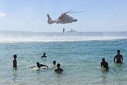 Coast Guard practicing a rescue at Crash Boat Beach | |
| Commonwealth | Puerto Rico |
| Municipality | Aguadilla |
| Ideal Areas for | |
| Lifeguards | Non Available |
| Safety | For All Ages |
| Playa Crash Boat | |
|---|---|
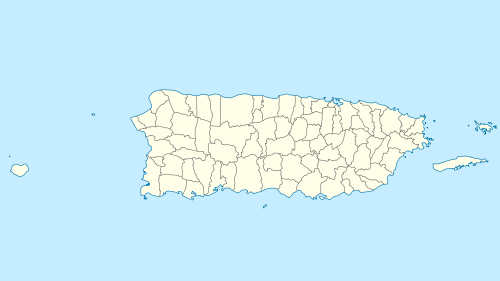 Location of Playa Crash Boat in Puerto Rico | |
| Location | Aguadilla, Puerto Rico |
| Coordinates | 18.458392°N 67.164863°W |

| Part of a series on |
| Tourism in Puerto Rico |
|---|
| Tourism Regions |
|
| Beaches |
|
| Caves |
| Cays and islets |
| Convention centers |
| Culture |
|
| Islands |
|
Crash Boat is halfway between the Ramey Air Force Base and Aguadilla and still retains some remains of its pier infrastructure from when it was used to rescue downed air crews from Ramey Air Force Base.[1] These pier remains are used as a fishing spot and for jumping into the waters. Crash Boat also has two large sand beach areas for general bathing. The beach is primarily accessed by taking PR-107 to a spur signed, PR-458.
Getting There
The closest passenger airport to Crash Boat is Rafael Hernández Airport(BQN), located 4 miles(6 km) away.[2] From Luis Muñoz Marín International Airport(SJU) in Carolina, it takes about 1 hour & 30 minutes (85 miles) to get to this beach. The easiest way is using the Highway PR-22/Expreso Jose de Diego towards the west for about 52 miles. Then stay straight to go onto PR-2 Highway for about 26 miles until you reach PR-107 which will be on your right. Once in PR-107 drive for about 1.2 miles when you will reach PR-458 on your left. PR-458 will take you directly towards Crash Boat Parking as it is a dead end road. There is public parking and the beach is easy to find.[3]
What can be done
- Swimming areas designated with buoys. Also some swimmers jump off the pier which is safe. Still, beware of low tides that may change water depth in order to prevent injuries.
- Sun Bathing: Excellent conditions year round but beware of the tropical sun as exposure without proper sunblock may create uncomfortable situations such as sunburns and moderate to extreme itching when healing.
- Surfing: Good for all surfing levels. The beach is known for being a surfing and body-boarding spot even though it is not an extremely consistent surf spot compared to the surrounding area. It requires a large swell to wrap around into the Aguadilla Bay area. On good surf days the crowds may be huge. Breaks best on west or northwest swell, with any wind.[4][5]
- Scuba and Snorkeling: There are many fish around the pier pillars with average depths of 30 feet. It has low currents (1 knot) and has good visibility (10–30 meters) which make it ideal for all divers.[6][7]
- Paddle boarding: this activity which has grown in recent years can be practiced here. There are rental stands where the proper equipment can be leased.
- Jet skiing and other motor boats: May be rented for use.[8]
- Sand: Many palm trees for shade while playing with the sand.
- Sunset: as Aguadilla is on the west side of Puerto Rico, sunsets can be seen from the beach.
- Walking: the beach is surrounded by mountains that offer a view of the shoreline and vegetation which can be explored using available walking trails.
- Shells: The beach has Mediterranean-style seashells which are sometimes collected by visitors.[9]
Name Origin
How the beach became to be known as "Crash boat" is not clear. There are some hypothesis about this. One is that the beach got its name from a large boat that crashed into the cement pier before turning south and sink on the beach.[9] The other hypothesis relates to the use of the beach by the US military during World War II, with the dock being built to accommodate the Crash Rescue Boats Squadron, with the beach referred to as Crash boat. This "Crash Rescue Boats Squadron" from the United States Air Force used to keep rescue boats here to pick up crews from the Air Force flying boats and other aircraft that were disabled at sea and couldn't make the runway at nearby Ramey Air Force Base."[10] The Crash Boat Beach pier / dock was originally built with fuel pipe that pumped aircraft grade fuel for Ramey Air Force Base. As time passed, local currents dropped tons of sand into the beach and pier area, making it unusable to dock a boat at the pier.[4]
Gallery
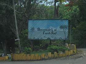 Bienvenidos al Crash Boat welcome sign at beach
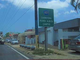 PR-107 towards Crash Boat
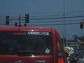 Crashboat Beach sticker on vehicle on PR-107
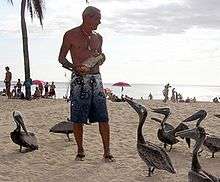
 Pelican at Crash Boat beach (2014)
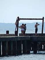 On the pier where people jump off into the ocean
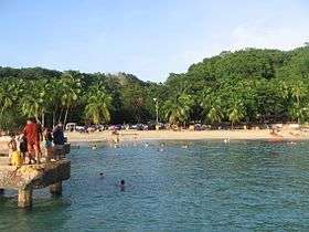 Crash Boat, Summer 2008
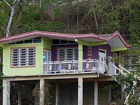 House up on the hills at Crash Boat Beach
See also
References
- Smith, D.C. (1995). Antilles (in Danish). Vantage Press. p. 42. ISBN 978-0-533-11446-7. Retrieved 2019-07-21.
- "Crash Boat Surf Forecast". surf-forecast.com. Retrieved 25 May 2018.
- Barbara Balletto (2003). Insight Guide Puerto Rico. Langenscheidt Publishing Group. pp. 196–. ISBN 978-981-234-949-1.
- "Crash Boat – Surf Spot in Aguadilla". goseepr. Retrieved 25 May 2018.
- "Surf West PR". surfingpuertorico. Retrieved 25 May 2018.
- Sport Diver. 1997-01-01. p. 81.
- "CRASH BOAT PIERS". wannadive.net. Retrieved 25 May 2018.
- Jainchill, Johanna (December 13, 2017). "Puerto Rico tourism coming back gradually". travelweekly. Retrieved 25 May 2018.
- "Crash Boat Beach and Aquadilla's Mediterranean Ocean Ambiance". puertorico.com. Retrieved 25 May 2018.
- "Playa Crash Boat". lonelyplanet. Retrieved 25 May 2018.
External links
- TripAdvisor
- Three Best Beaches - Puerto Rico: Aguadilla Beaches at The Best Beaches of the World
- Descubra Puerto Rico More Crash Boat Pictures
- OpenStreet Map
- Weather Channel Forecast Aguadilla Weather
- Crashboat Surf Forecast