Suffolk County, Massachusetts
| Suffolk County, Massachusetts | ||
|---|---|---|
| County of Massachusetts | ||
| County of Suffolk | ||
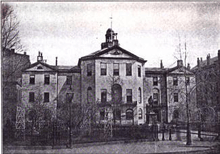
 Suffolk County Courthouse | ||
| ||
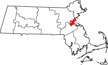 Location in the U.S. state of Massachusetts | ||
 Massachusetts's location in the U.S. | ||
| Founded | May 10th, 1643 | |
| Named for | Suffolk | |
| Seat | Boston | |
| Largest city | Boston | |
| Area | ||
| • Total | 120 sq mi (311 km2) | |
| • Land | 58 sq mi (150 km2) | |
| • Water | 62 sq mi (161 km2), 52% | |
| Population (est.) | ||
| • (2017) | 797,939 | |
| • Density | 13,758/sq mi (5,312/km2) | |
| Congressional districts | 5th, 7th, 8th | |
| Time zone | Eastern: UTC−5/−4 | |

Suffolk County is a county in the Commonwealth of Massachusetts, in the United States. As of 2016, the population was 784,230[1] making it the fourth-most populous county in Massachusetts. The traditional county seat is Boston, the state capital and the largest city in Massachusetts.[2] The county government was abolished in late 1999, and so Suffolk County today functions only as an administrative subdivision of state government and a set of communities grouped together for some statistical purposes. Suffolk County constitutes the core of the Boston-Cambridge-Newton, MA-NH Metropolitan Statistical Area as well as the greater Boston-Worcester-Providence, MA-RI-NH-CT Combined Statistical Area.
History
The county was created by the Massachusetts General Court on May 10, 1643, when it was ordered "that the whole plantation within this jurisdiction be divided into four shires". Suffolk initially contained Boston, Roxbury, Dorchester, Dedham, Braintree, Weymouth, and Hingham.[3] The county was named after Suffolk, England, which means "southern folk."[4]
In 1731, the extreme western portions of Suffolk County, which included Uxbridge, were split off to become part of Worcester County. In 1793, most of the original Suffolk County (including Milton) except for Boston, Chelsea, Hingham, and Hull (which remained in Suffolk) split off and became Norfolk County. Hingham and Hull would leave Suffolk County and join Plymouth County in 1803.[5] Revere was set off from Chelsea and incorporated in 1846 and Winthrop was set off from Revere and incorporated in 1852. In the late 19th century and early 20th century, Boston annexed several adjacent cities and towns including Hyde Park, Roxbury, West Roxbury, and Dorchester from Norfolk County and Charlestown and Brighton from Middlesex County, resulting in an enlargement of Suffolk County.
Government and politics
Like an increasing number of Massachusetts counties, Suffolk County exists today only as a historical geographic region, and has no county government.[6] All former county functions were assumed by state agencies in 1999. The sheriff, district attorney, and some other regional officials with specific duties are still elected locally to perform duties within the county region, but there is no county council, executives or commissioners. Immediately prior to the abolition of county government, the authority of the Suffolk County Commission had for many years been exercised by the Boston City Council, even though three communities in the county are not part of the city. However, communities are now granted the right to form their own regional compacts for sharing services.[7] Politically speaking, Suffolk County supports the Democratic Party overwhelmingly. No Republican presidential candidate has won there since Calvin Coolidge in 1924. In 2012 Barack Obama received 77.4% of the vote, compared to 20.8% for Mitt Romney. In the 2014 gubernatorial election, Martha Coakley carried the county by a 32.4% margin, while losing the election statewide by 48.4 to 46.5%.
| Voter registration and party enrollment as of October 15, 2008[8] | |||||
|---|---|---|---|---|---|
| Party | Number of voters | Percentage | |||
| Democratic | 234,443 | 54.46% | |||
| Republican | 31,271 | 7.26% | |||
| Unenrolled | 161,320 | 37.47% | |||
| Minor Parties | 3,489 | 0.81% | |||
| Total | 430,523 | 100% | |||
| Year | Republican | Democratic | Third parties |
|---|---|---|---|
| 2016 | 16.1% 50,421 | 78.4% 245,751 | 5.5% 17,111 |
| 2012 | 20.8% 59,999 | 77.5% 223,896 | 1.8% 5,203 |
| 2008 | 21.2% 57,194 | 76.9% 207,128 | 1.8% 4,900 |
| 2004 | 22.8% 54,923 | 75.9% 182,592 | 1.3% 3,130 |
| 2000 | 20.5% 44,441 | 71.4% 154,888 | 8.2% 17,671 |
| 1996 | 19.9% 39,753 | 73.0% 145,586 | 7.1% 14,053 |
| 1992 | 23.4% 51,378 | 60.6% 132,921 | 16.0% 34,974 |
| 1988 | 34.4% 77,137 | 64.0% 143,677 | 1.6% 3,596 |
| 1984 | 37.4% 91,563 | 62.3% 152,568 | 0.4% 866 |
| 1980 | 33.9% 73,271 | 52.5% 113,416 | 13.7% 29,520 |
| 1976 | 34.7% 80,623 | 61.1% 142,010 | 4.2% 9,739 |
| 1972 | 33.7% 85,272 | 65.8% 166,250 | 0.5% 1,299 |
| 1968 | 18.2% 48,952 | 75.6% 203,406 | 6.2% 16,619 |
| 1964 | 13.5% 40,251 | 86.2% 257,161 | 0.3% 842 |
| 1960 | 25.3% 85,750 | 74.4% 252,823 | 0.3% 1,044 |
| 1956 | 45.8% 162,836 | 53.8% 191,245 | 0.5% 1,605 |
| 1952 | 40.1% 162,147 | 59.5% 240,957 | 0.4% 1,775 |
| 1948 | 27.4% 105,671 | 69.0% 265,611 | 3.6% 13,785 |
| 1944 | 37.2% 139,285 | 62.6% 234,475 | 0.2% 727 |
| 1940 | 36.1% 138,575 | 63.3% 243,233 | 0.6% 2,337 |
| 1936 | 27.6% 96,418 | 63.9% 223,732 | 8.5% 29,860 |
| 1932 | 30.0% 88,737 | 67.1% 198,792 | 2.9% 8,543 |
| 1928 | 32.5% 99,392 | 66.8% 204,603 | 0.7% 2,135 |
| 1924 | 47.1% 104,658 | 35.5% 78,702 | 17.4% 38,633 |
| 1920 | 58.1% 108,089 | 36.3% 67,552 | 5.6% 10,457 |
| 1916 | 40.0% 42,492 | 57.5% 61,047 | 2.5% 2,609 |
| 1912 | 24.7% 24,179 | 47.1% 46,059 | 28.2% 27,613 |
| 1908 | 48.5% 46,337 | 45.8% 43,773 | 5.7% 5,429 |
| 1904 | 44.1% 43,681 | 52.3% 51,714 | 3.6% 3,569 |
| 1900 | 44.8% 40,951 | 52.0% 47,534 | 3.2% 2,880 |
| 1896 | 59.9% 53,633 | 35.5% 31,744 | 4.7% 4,174 |
| 1892 | 43.4% 35,304 | 54.7% 44,504 | 2.0% 1,584 |
| 1888 | 44.2% 31,191 | 54.6% 38,540 | 1.3% 921 |
| 1884 | 36.9% 23,283 | 54.8% 34,621 | 8.4% 5,278 |
| 1880 | 49.2% 28,346 | 50.1% 28,861 | 0.7% 396 |
| 1876 | 47.5% 22,832 | 52.2% 25,101 | 0.3% 141 |
Geography
According to the U.S. Census Bureau, the county has a total area of 120 square miles (310 km2), of which 58 square miles (150 km2) is land and 62 square miles (160 km2) (52%) is water.[10] It is the second-smallest county in Massachusetts by land area and smallest by total area.
Adjacent counties
- Essex County (north)
- Norfolk County (south)
- Middlesex County (west)
Suffolk County has no land border with Plymouth County to its southeast, but the two counties share a water boundary in the middle of Massachusetts Bay.
National protected areas
Major Highways
Demographics
| Historical population | |||
|---|---|---|---|
| Census | Pop. | %± | |
| 1790 | 44,865 | — | |
| 1800 | 28,015 | −37.6% | |
| 1810 | 34,381 | 22.7% | |
| 1820 | 43,940 | 27.8% | |
| 1830 | 62,163 | 41.5% | |
| 1840 | 95,773 | 54.1% | |
| 1850 | 144,517 | 50.9% | |
| 1860 | 192,700 | 33.3% | |
| 1870 | 270,802 | 40.5% | |
| 1880 | 387,927 | 43.3% | |
| 1890 | 484,780 | 25.0% | |
| 1900 | 611,417 | 26.1% | |
| 1910 | 731,388 | 19.6% | |
| 1920 | 835,522 | 14.2% | |
| 1930 | 879,536 | 5.3% | |
| 1940 | 863,248 | −1.9% | |
| 1950 | 896,615 | 3.9% | |
| 1960 | 791,329 | −11.7% | |
| 1970 | 735,190 | −7.1% | |
| 1980 | 650,142 | −11.6% | |
| 1990 | 663,906 | 2.1% | |
| 2000 | 689,807 | 3.9% | |
| 2010 | 722,023 | 4.7% | |
| Est. 2017 | 797,939 | [11] | 10.5% |
| U.S. Decennial Census[12] 1790-1960[13] 1900-1990[14] 1990-2000[15] 2010-2013[16] | |||
As of the 2010 United States Census, there were 722,023 people, 292,767 households, and 140,412 families residing in the county.[17] The population density was 12,415.6 inhabitants per square mile (4,793.7/km2). There were 315,522 housing units at an average density of 5,425.6 per square mile (2,094.8/km2).[18] The racial makeup of the county was 56.0% white, 21.6% black or African American, 8.2% Asian, 0.4% American Indian, 9.7% from other races, and 3.9% from two or more races. Those of Hispanic or Latino origin made up 19.9% of the population.[17] The largest ancestry groups were:[19]
- 16.4% Irish
- 10.4% Italian
- 5.2% English
- 5.1% Puerto Rican
- 4.3% German
- 3.8% Dominican
- 3.5% Chinese
- 3.4% Haitian
- 2.8% Salvadoran
- 2.6% Polish
- 2.5% French
- 2.0% American
- 1.8% Russian
- 1.7% Vietnamese
- 1.6% Cape Verdean
- 1.4% Colombian
- 1.4% Scottish
- 1.3% French Canadian
- 1.3% Arab
- 1.1% Jamaican
- 1.1% Mexican
- 1.1% Indian
- 1.1% Guatemalan
- 1.1% Portuguese
- 1.0% Honduran
- 1.0% Scotch-Irish
Of the 292,767 households, 24.4% had children under the age of 18 living with them, 27.1% were married couples living together, 16.3% had a female householder with no husband present, 52.0% were non-families, and 36.3% of all households were made up of individuals. The average household size was 2.30 and the average family size was 3.11. The median age was 31.5 years.[17]
The median income for a household in the county was $50,597 and the median income for a family was $58,127. Males had a median income of $48,887 versus $43,658 for females. The per capita income for the county was $30,720. About 15.7% of families and 20.6% of the population were below the poverty line, including 28.1% of those under age 18 and 19.1% of those age 65 or over.[20]
Demographic breakdown by town
Income
Data is from the 2007-2011 American Community Survey 5-Year Estimates.[21][22][23]
| Rank | Town | Area (land) | Per capita income |
Median household income |
Median family income |
Population | Number of households | |
|---|---|---|---|---|---|---|---|---|
| 1 | Winthrop | City | 2.0 sq mi (5.2 km2) | $36,624 | $61,744 | $81,647 | 17,430 | 7,356 |
| Massachusetts | State | $35,051 | $65,981 | $83,371 | 6,512,227 | 2,522,409 | ||
| 2 | Boston | City | 48.42 sq mi (125.41 km2) | $33,158 | $51,739 | $61,035 | 609,942 | 247,621 |
| Suffolk County | County | $32,034 | $51,638 | $60,342 | 713,089 | 286,437 | ||
| United States | Country | $27,915 | $52,762 | $64,293 | 306,603,772 | 114,761,359 | ||
| 3 | Revere | City | 5.9 sq mi (15.3 km2) | $25,085 | $50,592 | $58,345 | 50,845 | 19,425 |
| 4 | Chelsea | City | 2.2 sq mi (5.7 km2) | $20,214 | $43,155 | $46,967 | 34,872 | 12,035 |
Communities
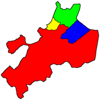
- Boston (traditional county seat)
- Chelsea
- Revere
- Winthrop
See also
References
- ↑ "U.S. Census Bureau QuickFacts: Suffolk County, Massachusetts". Census Bureau QuickFacts. Retrieved 9 May 2018.
- ↑ "Find a County". National Association of Counties. Archived from the original on 2011-05-31. Retrieved 2011-06-07.
- ↑ Davis, William T. Bench and Bar of the Commonwealth of Massachusetts, p. 44. The Boston History Company, 1895.
- ↑ Thomas Cox, Anthony Hall, Robert Morden, Magna Britannia Antiqua & Nova: Or, A New, Exact, and Comprehensive Survey of the Ancient and Present State of Great Britain, Volume 5, (Caesar Ward and Richard Chandler: London, 1738), pg. 171 (accessed on Google Book Search, June 22, 2008)
- ↑ "History of Norfolk County - Norfolk County". www.norfolkcounty.org. Archived from the original on 23 November 2016. Retrieved 9 May 2018.
- ↑ "CIS: Historical Data Relating to the Incorporation of Counties in the Commonwealth of Massachusetts". www.sec.state.ma.us. Retrieved 9 May 2018.
- ↑ See also: League of Women Voters page on counties Archived 2004-04-21 at the Wayback Machine..
- ↑ "Registration and Party Enrollment Statistics as of October 15, 2008" (PDF). Massachusetts Elections Division. Retrieved 2010-05-08.
- ↑ Leip, David. "Dave Leip's Atlas of U.S. Presidential Elections". uselectionatlas.org. Archived from the original on 23 March 2018. Retrieved 9 May 2018.
- ↑ "2010 Census Gazetteer Files". United States Census Bureau. August 22, 2012. Archived from the original on September 14, 2014. Retrieved September 16, 2014.
- ↑ "Population and Housing Unit Estimates". Archived from the original on May 29, 2017. Retrieved June 9, 2017.
- ↑ "U.S. Decennial Census". United States Census Bureau. Archived from the original on May 12, 2015. Retrieved September 16, 2014.
- ↑ "Historical Census Browser". University of Virginia Library. Archived from the original on August 16, 2012. Retrieved September 16, 2014.
- ↑ "Population of Counties by Decennial Census: 1900 to 1990". United States Census Bureau. Archived from the original on April 28, 2015. Retrieved September 16, 2014.
- ↑ "Census 2000 PHC-T-4. Ranking Tables for Counties: 1990 and 2000" (PDF). United States Census Bureau. Archived (PDF) from the original on December 18, 2014. Retrieved September 16, 2014.
- ↑ "State & County QuickFacts". United States Census Bureau. Archived from the original on July 20, 2011. Retrieved June 22, 2014.
- 1 2 3 "DP-1 Profile of General Population and Housing Characteristics: 2010 Demographic Profile Data". United States Census Bureau. Retrieved 2016-01-12.
- ↑ "Population, Housing Units, Area, and Density: 2010 - County". United States Census Bureau. Retrieved 2016-01-12.
- ↑ "DP02 SELECTED SOCIAL CHARACTERISTICS IN THE UNITED STATES – 2006-2010 American Community Survey 5-Year Estimates". United States Census Bureau. Retrieved 2016-01-12.
- ↑ "DP03 SELECTED ECONOMIC CHARACTERISTICS – 2006-2010 American Community Survey 5-Year Estimates". United States Census Bureau. Retrieved 2016-01-12.
- ↑ "SELECTED ECONOMIC CHARACTERISTICS 2007-2011 American Community Survey 5-Year Estimates". U.S. Census Bureau. Archived from the original on 2013-01-26. Retrieved 2013-01-26.
- ↑ "ACS DEMOGRAPHIC AND HOUSING ESTIMATES 2007-2011 American Community Survey 5-Year Estimates". U.S. Census Bureau. Archived from the original on 2013-02-14. Retrieved 2013-01-26.
- ↑ "HOUSEHOLDS AND FAMILIES 2007-2011 American Community Survey 5-Year Estimates". U.S. Census Bureau. Archived from the original on 2013-07-23. Retrieved 2013-01-26.
External links
| Wikimedia Commons has media related to Suffolk County, Massachusetts. |
- Suffolk County Sheriff's Department
- Suffolk County District Attorney
- Suffolk County Registry of Deeds
- Walling & Gray. 1871 Map of Boston, Suffolk, County and Nearby Towns Pages 48-49 from the 1871 Atlas of Massachusetts.
- National Register of Historic Places listing for Suffolk Co., Massachusetts
- Map of cities and towns of Massachusetts
Coordinates: 42°21′32″N 71°03′28″W / 42.35892°N 71.05781°W
Places adjacent to Suffolk County, Massachusetts | ||||||||||
|---|---|---|---|---|---|---|---|---|---|---|
| ||||||||||
Municipalities and communities of Suffolk County, Massachusetts, United States | ||
|---|---|---|
| Cities | | |
| Neighborhoods | ||