Chicopee, Massachusetts
| Chicopee, Massachusetts | |||
|---|---|---|---|
| City | |||
     Clockwise from top: Chicopee City Hall, Berchmans Hall at College of Our Lady of the Elms, the Polish Center of Discovery and Learning, Al's Diner, and the Carreau Block | |||
| |||
|
Nickname(s): Crossroads of New England Kielbasa Capital of the World[1][2] | |||
|
Motto(s): Industriæ Variæ (Latin) "Varied Industries"[3] | |||
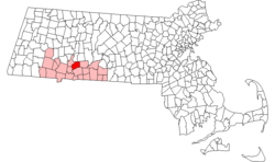 Location in Hampden County in Massachusetts | |||
 Chicopee, Massachusetts Location in the United States  Chicopee, Massachusetts Chicopee, Massachusetts (Massachusetts) | |||
| Coordinates: 42°08′55″N 72°36′30″W / 42.14861°N 72.60833°WCoordinates: 42°08′55″N 72°36′30″W / 42.14861°N 72.60833°W | |||
| Country |
| ||
| State |
| ||
| County |
| ||
| Settled | 1640 | ||
| Incorporated (town) | April 29, 1848 | ||
| Incorporated (city) | April 18, 1890 | ||
| Government | |||
| • Type | Mayor–council city | ||
| • Mayor | Richard Kos (R)[4][5] | ||
| Area | |||
| • Total | 23.9 sq mi (61.9 km2) | ||
| • Land | 22.9 sq mi (59.2 km2) | ||
| • Water | 1.0 sq mi (2.7 km2) | ||
| Elevation | 200 ft (61 m) | ||
| Population (2010) | |||
| • Total | 55,298 | ||
| • Estimate (2016)[6] | 55,991 | ||
| • Density | 2,300/sq mi (890/km2) | ||
| Time zone | UTC−05:00 (Eastern) | ||
| • Summer (DST) | UTC−04:00 (Eastern) | ||
| ZIP Codes | 01013, 01020, 01021, 01022 | ||
| Area code(s) | 413 | ||
| FIPS code | 25-13660 | ||
| GNIS feature ID | 0617597 | ||
| Website | www.chicopeema.gov | ||

Chicopee (/ˈtʃɪkəpi/ CHIK-ə-pee) is a city located on the Connecticut River in Hampden County, Massachusetts, United States of America. It is part of the Springfield, Massachusetts Metropolitan Statistical Area. As of the 2010 census, the city had a population of 55,298, making it the second largest city in Western Massachusetts after Springfield. The current mayor is Richard Kos.
Chicopee uses the nickname "Crossroads of New England" as part of a business-development marketing campaign, a nickname also shared by West Springfield. The name reflects the city's convenient location amongst a number of metropolitan areas and its transportation network. Four highways run through its boundaries: I-90, I-91, I-291, and I-391. State routes such as Route 33, 116, and 141, are major providers of regional linkage.
The communities of Chicopee Center (Cabotville), Chicopee Falls, Willimansett, Fairview, Smith Highlands, Aldenville, Burnett Road, and Westover are located in the city.
Name
The city is named after the Chicopee River, whose mouth empties into the Connecticut River on in its boundaries. "Chicopee" is a Nipmuc word, probably from chekee ("violent") and pe ("waters") in most Algonquian dialects, with reference to rapids. The Nipmucs were the indigenous people of the lands that today make up the City of Chicopee, prior to the arrival of European colonists.
Alternatively, chikkuppee ("of cedar") is the adjective form of chickkup ("cedar").[7]
History
Nayasett (Cabotville and Chicopee Falls)
In 1636, William Pynchon purchased land from the Agawam Indians on the east side of the Connecticut River and moved from Roxbury to Springfield to found the first settlement in the area that comprises the territory of today's Chicopee Center (Cabotville). Both Cabotville and the Falls began as manufacturing centers (villages).[8]
According to local historian Charles J. Seaver, the area above the falls was first settled in 1660. The land purchased from the Indians was divided into districts. Nayasett (Nipmuc for "at the small point/angle") was the name given to Chicopee Center and Chicopee Falls. The settlement in the upper district was at Skipmuck (possibly based on Nipmuc "Skipmaug," meaning "chief fishing place" or "Shipmuck," meaning "big watery place"), a place above the falls on the south side of the river.
A sawmill was the first river industry. The mill was built at Skenungonuck (Nipmuc for "green fields") Falls (now Chicopee Falls) in 1678 by Japhet Chapin, John Hitchcock and Nathaniel Foote. The mill was the first industrial site in Chicopee Falls. The saga of Factory Village really begins in the year 1786, when the property comprising two acres of land was leased to 10 local men with the understanding that they would build an iron foundry within two years. This was accomplished and the business flourished.

Photo by Lewis Hine.
In 1823, Jonathan Dwight purchased the water privilege at Skenungonuck Falls in Chicopee. Five years later the textile mill had 14,000 spindles and nearly 500 looms, making it the second-largest operation in the state. By 1831, there were two giant dams, two waterpower canals and two manufacturing communities on the Chicopee River.
In 1848, Chicopee, which for over two centuries had been a part of Springfield, was partitioned off into its own town. Political factions in Springfield wanted Springfield to remain a town, rather than become a city and take on a mayoral form of government. By partitioning off Chicopee, those political factions prevented Springfield from becoming a city until 1852; however, Springfield lost 2/5 of its land area and nearly half of its population when Chicopee was created.
Before and after the partition, eight Chicopee River companies gained product recognition around the globe: Ames, Belcher, Lamb, Dwight, Stevens, Spalding, Fisk, and Duryea. Below the falls in the bend of the river at a place called Factory Village, an important chapter of the region's industrial history was played out.
Various industries
Chicopee adopted the motto "Industriae Variae", which means "Various Industries". Chicopee was home to many types of industries which include cotton mills, woolen mills, textiles, brass foundries and iron foundries, paper making, leather products like boots and shoes, the first lucifer matches, and ship building for the nearby South Hadley Canal, firearms company Crescent-Davis, which specialized in double barrel shotguns.
The Ames Manufacturing Company made many machines and bronze cannons, and more swords than any other American manufacturer at the time. Ames cast a number of bronze statues, including Thomas Ball's monumental equestrian statue of George Washington, installed in Boston's Public Garden. Ames was a major provider of cannon to the Union army during the Civil War.[9] The Stevens Arms plant (later Savage) was responsible for most of the Number 4 Enfields manufactured for the British under Lend-Lease. Chicopee was home to production of the first gasoline-powered automobile made in the United States, the Duryea.[10][11]
Bicycles
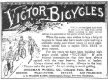
During the late Nineteenth Century, Chicopee Falls became a major manufacturing center of bicycles.[12] The town was the site of at least two bicycle factories: The Overman Wheel Company (1882 to about 1899), and the Spalding sporting goods company.[13]
Albert H. Overman moved his bicycle production from Hartford to Chicopee Falls in 1883.[12] The Overman company benefited the surging popularity of the safety bicycle during the bicycle boom of the 1890s. At its height in 1894 Overman's factory employed over 1,200 workers. The boom eventually went bust, as overproduction drove the price of bicycles down. By 1901 the Overman firm was out of business.[12]
Library
Chicopee was the first city west of Boston to form a publicly funded public library. The Chicopee Public Library was formed by a donation to the city by the Cabotville Institute.

Neighborhoods
Willimansett
In 1641, Willian Pynchon expanded his 1636 holdings by buying the land from the Chicopee River north to the Willimansett (Nipmuc for "good berries place" or "place of red earth") Brook. Land sales in Chicopee were recorded in 1659, but apparently no homes were built immediately.
Winthrop McKinstry writes that the sons of Deacon Samuel Chapin appear to be the first home builders. Henry Chapin is believed to have constructed his at Exchange and West streets (lower Chicopee) in 1664, and Japhet Chapin north of what is now known as James Ferry Road (upper Chicopee) in 1673. It is apparent from McKinstry's book that the Chapin family dominated the area north of the Chicopee River for the settlement's first 70 years. Chicopee Street was part of the First Parish in Springfield.
By the 1750s, Quabbin Road (now McKinstry Avenue) allowed the farmers to access the meadows and fields on the plains at the top of the hill. The Chapins used the land in common for grazing livestock and built ice houses near several large ponds. The ponds were drained by several brooks which flowed into the Connecticut River.
At the end of the 19th century, the city voted to build the Willimansett Bridge, connecting Willimansett with Holyoke. The results were profound. Willimansett and Aldenville would develop close ties to Holyoke; even postal and telephone service were (and still are) tied to the "Paper City." The legislative act ordering the building of the bridge was passed in 1892. L.L. Johnson reports that the completion of the bridge was grandly celebrated.
By the 20th century, Willimansett village had developed into quintessential Americana with a high percentage of French Canadian inhabitants. In total, Chicopee became four distinct commercial and political sub-divisions, each with its own ethnic makeup representing its own special interests and, much too frequently, in conflict with each other.
Located between Fairview and Willimansett, the Smith Highlands section once had its own school (first and second grades), Holyoke Street Railway bus service from Ingham Street across Irene, Factory, and Prospect streets, and two locally owned markets. The former Robert's Pond swimming area was a popular summer attraction, and the fields where the current Bellamy Junior High School is located were a popular sledding and skiing location winters.
Fairview
Fairview is the northern-most neighborhood (village) in Chicopee and originally included the lands that are now part of Westover ARB. Primarily agricultural, Fairview was known for its tobacco farms. After 1939, Westover helped to rapidly develop the village into a residential and commercial district. Memorial Drive (Route 33) flows North-South connecting Chicopee Falls with South Hadley.
Aldenville
On August 18, 1870, Edward Monroe Alden purchased 600 acres of land just east of Willimansett for the sum of $9,000 with the intent to create a "little city on the hill," which would become Aldenville. In 1890, he began laying out streets which he named for family members and divided the land up into 60-by-170 feet lots. French-Canadian factory workers from Chicopee Falls, Cabotville (Chicopee Center), and Holyoke began to build up the community. Sold for a selling price of $150 with $10 down, the first house was bought and built by French-Canadian builder and carpenter Marcellin Croteau.[14]
Partition from Springfield and modern history
The villages of Cabotville, Chicopee Falls, Willimansett, and Fairview (and the lands that would become Aldenville) remained a part of Springfield, Massachusetts, from 1636 until 1848, when they were partitioned to form the Town of Chicopee. Political factions in Springfield had wished to keep Springfield a "town," instead of becoming a "city," which would give it a mayoral form of government. To keep Springfield sufficiently unpopulated to subvert a state regulation that would have required it to become a city, they partitioned Chicopee, which contained approximately 2/5 of Springfield's land area, and nearly half of its population.
Regardless of the partition, Springfield became a city only four years after the partition of Chicopee. Both cities continued to flourish for over a century after the partition.
On April 18, 1890, the community was granted a charter as a city by the Massachusetts General Court. George Sylvester Taylor (1822–1910) became Chicopee's first mayor on January 5, 1891.
Westover Field was created by a war-readiness appropriation signed by president Franklin D. Roosevelt in 1939. The site used to be tobacco crop fields east of and part of Fairview, east of Aldenview, and northern Willimansett. It was assigned to the United States Army Air Corps Northeast Air District. It was renamed Westover Air Force Base in 1948 after that Air Force's creation as a separate service. In 1974 SAC leadership turned the base over to the Air Force Reserve.
In 1991, St. Stanislaus Bishop and Martyr Church, located on Front Street, was proclaimed a minor basilica by Pope John Paul II.
Geography
Chicopee is located at 42°10′13″N 72°35′19″W / 42.17028°N 72.58861°W (42.170159, -72.588630).[15]
The city is made up of several neighborhoods; the result of the city's origin as a collection of four villages in the northernmost part of Springfield, which seceded from it in 1848. Chicopee Falls, Chicopee Center (Cabotville), Fairview, and Willimansett continued to develop. In the early 1900s, Aldenville developed as a distinct community. Since then, the city has filled in most of its open space resulting in a number of new neighborhoods. These neighborhoods include Chicomansett, Ferry Lane, Sandy Hill and the geographically isolated Burnett Road neighborhood.
The city is bordered by Holyoke to the northwest, West Springfield to the southwest, Springfield to the south, Ludlow to the east, Granby to the northeast and South Hadley to the north. Chicopee is located 29 miles (47 km) away from Hartford, 89 miles (143 km) away from Boston, 90 miles (140 km) from Albany and 140 miles (230 km) from New York City.
According to the United States Census Bureau, the city has a total area of 23.9 square miles (62 km2), of which 22.9 square miles (59 km2) is land and 1.0 square mile (2.6 km2) (4.31%) is water. The Chicopee River flows through the south part of the city, emptying into the Connecticut River. Many ponds, lakes, and streams are part of the Chicopee River or Connecticut River watersheds.
Willimansett, and portions of the Center and Falls are on low land, with Aldenville, Fairview, Westover, and the Burnett Road neighborhoods on an elevated plateau. At 288 feet, the highest elevation in the city is on Old Lyman Road, in the Fairview section.
Culture
Events

- The Great New England Air Show is an annual two-day air show held at Westover Air Reserve Base. 300,000 visitors attended in 2008 to a show that featured the USAF Thunderbirds. Approximately 210,000 attended the highly anticipated 2012 show, Although no major jet team headlined the show, military demonstrations by the F/A-18F Super Hornet, F-15C Eagles, V-22 Osprey, B-2 Spirit Stealth Bomber, and a locally based C-5 Galaxy along with civilian aerobatics and warbirds kept spectators entertained; over 60 aircraft were on static display making it the biggest airshow to take place at that location since 1974. The next air show is scheduled for July 14 and 15, 2018 celebrating the 78th anniversary of Westover ARB with the US Navy's Blue Angels headlining in their first appearance at the base.[16]
- The Sword Game is an annual football game that began in 1964 after the founding of Chicopee's second high school, Chicopee Comprehensive High School. It is held every fall between Chicopee High School and Chicopee Comprehensive High School. The city's mayor presents the winning team with the Mayor's Sword, a sword that was manufactured in the 1890s by Ames Manufacturing Company in Cabotville.
- The World Kielbasa Festival is a four-day fair featuring Polish food, polka dancing, games, and rides. The original K-Fest was held by the Chicopee Chamber of Commerce's Fireball Club and ran from 1974 until 1997. It was dormant for years, and then revived and held at Szot Park in May 2015. In May 2016, Chicopee's Kielbasa Festival became part of a larger cultural event when it was moved to the Big E grounds in West Springfield.
Sites

- Ames Tower – in Cabotville, it was part of the Ames Manufacturing facilities and is now part of the Ames Privilege Apartment complex.
- Frank J. Szot Memorial Park – is a focal point for community events in the city with accommodations for baseball, basketball, and picnicking. The stadium is typically used for local and regional soccer and football games. Features include a pond, two WWII tanks, several war monuments, and a fountain.
- Chicopee Memorial State Park – is located in the Burnett Road neighborhood and used to be known as the Cooley Brook Reservoir and Watershed, the Chicopee Memorial State Park has been developed into a high use active recreation area. The total area is 575 acres (2.33 km2) including two 25-acre (100,000 m2) ponds. Activities include swimming, fishing, picnicking, jogging and biking.
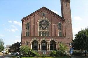
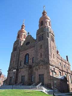
- The Basilica of Saint Stanislaus, located on Front Street, is a 1908 brownstone, cathedral-like church built in the Baroque Revival Style of architecture. It is regarded as one of the most imposing churches in the area. The interior of the church can accommodate approximately 800 worshipers in the main and two side naves. A pipe organ was installed in the choir loft in 1920. During the parish's 1991 centennial, Pope John Paul II designated it a Minor Basilica.
- The Cabotville Historic Sycamore Trees – are trees that were present when Chicopee became a town in 1848, matured when it became a city in 1890. They were designated Heritage Trees in 1999 by the Commonwealth of Massachusetts.
- The Chicopee Canal Walk – dedicated on May 21, 2010, is a 1,100-foot (340 m) pedestrian walkway and mini park that follows the canal from the Cabotville Historic Sycamore Trees to Grape Street. The path follows a portion of a former industrial railway. Plans are to extend the path to the Deady Bridge, creating a bicycle and pedestrian route connecting Cabotville and Chicopee Falls.
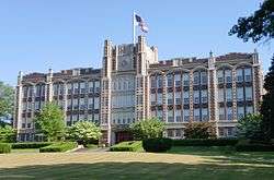
- The Chicopee City Hall – was built in 1871 in the Romanesque style. It was added to the National Register of Historic Place on July 30, 1974.
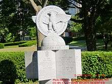
- The Chicopee War Memorial – is located off of the intersection of Bonneville Avenue and Front Street. It is home to several statues and monuments to World War II veterans and Vietnam War veterans.
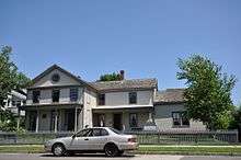
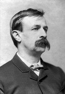
- The Edward Bellamy House – is a National Historic Landmark at 91–93 Church Street in Chicopee Falls, Massachusetts. The house was built in 1852 and was the home of journalist Edward Bellamy. The house was added to the National Register of Historic Places and designated a National Historic Landmark in 1971.
- The Emerson Gaylord Mansion – is a historic mansion is located at the north edge of the Elms College campus on the corner of Springfield and Fairview Streets (199 Springfield Street). It is described by Kristin O'Connell ("The Architectural Heritage of Chicopee") as a less pure example of the French Second Empire style, because of its asymmetrical exterior and its unusually high steep roof.
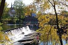
- The Facemate Tower – is a historic tower on the Chicopee River in Chicopee Falls. It used to be a part of the Facemate Industrial Complex.
- The Polish Center of Discovery and Learning is a local history museum celebrating contributions made to the economy, arts, and sciences by immigrant Poles and their ancestors in Western New England. The museum also sponsors regular workshops, exhibits, concerts, conferences, seminars, films, plays, and lectures regarding the cultural traditions, contributions, and history of Poland, the Polish people, and the Polish diaspora.
- The Uniroyal Office Building – is a historic building in Chicopee Falls that was part of the Uniroyal Industrial Complex.
- The Willimansett Dike – is an elevated, artificial levee in Willimansett, built after the destructive Willimansett flood caused by The Great New England Hurricane of 1938. It stretches from Nash Field, following the Connecticut River south to I-90 bridge adjacent to the Chicopee boat ramp.
- Westover Air Reserve Base – was built here in 1940. Originally an Army Air Corps and later Army Air Forces installation known as Westover Field, it became Westover Air Force Base when the Air Force became an independent service in 1947. From 1955 until 1974, it was a Strategic Air Command (SAC) installation. Transferred to the Air Force Reserve in 1974, it was renamed Westover Air Reserve Base and is now the home of the 439th Airlift Wing, flying the C-5 Galaxy aircraft.[17] Westover has one of the largest runways on the east coast at 11,597 x 301 feet (92 m) and is the largest Air Force Reserve base in the United States.[18][19] A joint civil-military facility, it is also home to Westover Metropolitan Airport.[20] Two military-minded youth programs, the Young Marines and the Westover Composite Squadron of the Civil Air Patrol are also located at Westover.
Economy
Chicopee is mostly a service economy with a mixture of small, local businesses and national chains. Reflecting the city's history, many businesses are Polish-American and include the Chicopee Provision Company, a major producer of Polish sausage kielbasa under the Blue Seal brand, and Millie's Pierogi, a producer of traditional Polish dumplings called pierogi.
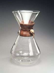
Despite changes in the global economy, Chicopee does remain home to manufacturers including Callaway Golf which produces more than 5 million golfballs a year at its Willamansett production plant.[21] Since 2013, Chicopee has been home to the headquarters of the Chemex Corporation, makers of the Chemex pour-over coffeemaker, which has been produced with the same design since 1941.[22][23] Chicopee also hosts the Buxton Company, which "designs, manufactures, and markets personal leather goods, travel kits, and gifts collections for men and women." Founded as L.A.W. Novelty Co. in 1898, the firm changed its name to Buxton Co., LLC in 1921.[24]
Chicopee is home to a handful of financial businesses as well including Alden Credit Union,[25] The Polish National Credit Union[26] and Chicopee Savings Bank.[27] Chicopee Savings Bank is run by Chicopee Bancorp, which operates trades as CBNK on the NASDAQ exchange.
The Chicopee River Business Park and Westover Business Park are within the city's boundaries.
Demographics
| Historical population | ||
|---|---|---|
| Year | Pop. | ±% |
| 1850 | 8,291 | — |
| 1860 | 7,261 | −12.4% |
| 1870 | 9,607 | +32.3% |
| 1880 | 11,286 | +17.5% |
| 1890 | 14,050 | +24.5% |
| 1900 | 19,167 | +36.4% |
| 1910 | 25,401 | +32.5% |
| 1920 | 36,214 | +42.6% |
| 1930 | 43,930 | +21.3% |
| 1940 | 41,664 | −5.2% |
| 1950 | 49,211 | +18.1% |
| 1960 | 61,553 | +25.1% |
| 1970 | 66,676 | +8.3% |
| 1980 | 55,112 | −17.3% |
| 1990 | 56,632 | +2.8% |
| 2000 | 54,653 | −3.5% |
| 2010 | 55,298 | +1.2% |
| 2016 | 55,991 | +1.3% |
| * = population estimate. Source: United States Census records and Population Estimates Program data.[28][29][30][31][32][33][34][35][36][37] Source: | ||
As of the census of 2010, Chicopee was 3.1% black, 1.6% Asian, 18.5% Hispanic or Latino of any race, 75% white
As of the census[39] of 2000, there were 54,653 people, 23,117 households, and 14,147 families residing in the city. The population density was 2,389.7 people per square mile (922.7/km²). There were 24,424 housing units at an average density of 1,067.9 per square mile (412.3/km²). The racial makeup of the city was 89.82% White, 2.28% African American, 0.20% Native American, 0.87% Asian, 0.10% Pacific Islander, 4.90% from other races, and 1.84% from two or more races. Hispanic or Latino of any race were 8.76% of the population (12.8% Puerto Rican, 0.5% Dominican, 0.4% Mexican, 0.2% Colombian). Chicopee is the second largest municipality in Western Massachusetts, after Springfield (defining Western Massachusetts as Hampden, Hampshire, Franklin, and Berkshire counties).
There were 23,117 households out of which 26.5% had children under the age of 18 living with them, 42.6% were married couples living together, 14.2% had a female householder with no husband present, and 38.8% were non-families. 32.7% of all households were made up of individuals and 14.1% had someone living alone who was 65 years of age or older. The average household size was 2.32 and the average family size was 2.96.
In the city, the population was spread out with 22.6% under the age of 18, 8.5% from 18 to 24, 28.8% from 25 to 44, 22.5% from 45 to 64, and 17.6% who were 65 years of age or older. The median age was 39 years. For every 100 females, there were 90.7 males. For every 100 females age 18 and over, there were 87.1 males.
The median income for a household in the city was $35,672, and the median income for a family was $44,136. Males had a median income of $35,585 versus $25,975 for females. The per capita income for the city was $18,646. About 9.6% of families and 12.3% of the population were below the poverty line, including 19.5% of those under age 18 and 9.3% of those age 65 or over.
Education
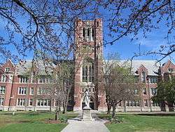
College of Our Lady of the Elms
The College of Our Lady of the Elms is a four-year liberal arts college offering thirty-three academic majors. It was first founded in 1897 as a girls' preparatory academy in Pittsfield, the Academy of Our Lady of the Elms. In 1899, it moved to Chicopee as St. Joseph's Normal College. A charter for the school to operate as a women's liberal arts college was approved in 1928, and the name was changed to the College of Our Lady of the Elms. It began admitting men in 1998.
Public schools (K-12)
The City of Chicopee operates fifteen public schools within the Chicopee School District, serving 7800 students. Richard W. Rege is the superintendent. There are nine elementary schools, two middle schools, one early childhood center, and three high schools (Chicopee High School, Chicopee Comprehensive High School and Chicopee Academy).
- Szetela Early Childhood Center
- Anna E. Barry Elementary School
- Belcher Elementary School
- Patrick Bowe Elementary School
- Bowie Memorial Elementary School
- Fairview Veterans Memorial Elementary School
- Lambert-Lavoie Elementary School
- Robert R. Litwin Elementary School
- Selser Memorial Elementary School
- Stefanik Memorial Elementary School
- Streiber Memorial Elementary School
- Edward Bellamy Middle School
- DuPont Memorial Middle School
- Hampden Charter School of Science
- Chicopee Comprehensive High School
- Chicopee High School
- Chicopee Academy
- Hampden Charter School of Science
Private elementary
Chicopee has a multitude of Catholic schools that are operated under the Diocese of Springfield. These schools include: Saint Joan of Arc School which serves Saint Rose de Lima Church on Grattan Street; and Saint Stanislaus School which serves the St. Stanislaus Bishop & Martyr's Parish Bishop and Martyr on Front Street.
Within the past decade, a number of private elementary schools and their associated parishes have closed. These include Assumption School which served the former Assumption of the Blessed Virgin Mary parish, Saint Patrick's School which served the former Saint Patrick's parish (closure of this parish is currently in dispute), Holy Name School which served Holy Name of Jesus parish, Mount Carmel School which served the Nativity of the Blessed Virgin Mary parish, and Saint George School which served Saint George's parish that merged with Saint Rose de Lima / Saint Joan of Arc School.
Private secondary

Holyoke Catholic High School was founded in 1963 at the campus of the former Saint Jerome High School in Holyoke. In 2002 it relocated to the campus of Saint Hyacinth Seminary in Granby. It moved to its current location in September 2008.
Notable people
- Scott Barnes, pitcher for Major League Baseball's Toronto Blue Jays
- Fred Belcher, American Race Car Driver, ran in the inaugural Indianapolis 500
- Edward Bellamy, author, most known for 1888's Looking Backward
- Teddy Charles, musician
- Duryea brothers, Charles Duryea (1861–1938) and Frank Duryea (1869–1967), were the first to build an automobile in the United States
- Damien Fahey, television and radio personality, former host of MTV's TRL
- Ray Fitzgerald, Major League Baseball player
- George S. Irving, actor and singer
- Joe Jackson, gridiron football player
- Philip Labonte, musician, vocalist for All That Remains
- Arthur MacArthur Jr., Army General
- Victoria Principal, attended Chicopee Comprehensive High School through her junior year, 1968
- George D. Robinson, Former Massachusetts Governor and defense counsel of Lizzie Borden
- Garry St. Jean, former NBA basketball coach for the Sacramento Kings
See also
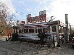
- Al's Diner
- Ames Manufacturing Company
- Cabotville Common Historic District
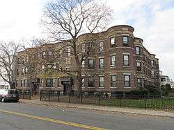
- Carreau Block
- Chicopee Falls Dam
- Dwight Manufacturing Company Housing District
- Overman Wheel Company
- List of mill towns in Massachusetts
- Polish Cathedral style
- Polish National Home
- Springfield Street Historic District
- Belcher Lodge
- Valentine School
- Westover Metropolitan Airport
- Willimansett Bridge
References
- ↑ Trausch, Susan (1990), "There is Life Beyond Boston – Really," The Boston Globe, June 6, 1990, p. 17: "[Springfield] has Chicopee, "Kielbasa Capital of the World," right next door."
- ↑ "'King Kielbasa' unveiled," Archived 2017-09-21 at the Wayback Machine. UPI, September 5, 1984: "[Chicopee Provision Co.] has been making the kielbasa since the festival began in 1974 to boost tourism in the western Massachusetts city of about 55,000, which has a large Polish population and calls itself the Kielbasa Capital of the World." Retrieved September 20, 2017.
- ↑ Plourde-Barker, Michele (1998). Chicopee. Arcadia. p. 29. Archived from the original on 2015-12-08.
- ↑ Lovelace, Curt (26 November 2002). "Republicans Give Thanks". Mass News. Archived from the original on 12 January 2016. Retrieved 17 September 2015.
Mayor Richard Kos of Chicopee did nothing to dispel the mood when he proclaimed, 'There is an excitement in the air.' He went on to urge candidates to make sure that they 'stand for something." He added, 'If you stand for nothing, people will fear that you'll fall for anything.' Decrying government waste and the emphasis on 'bringing home the pork,' the four-term Republican Mayor, proclaimed.
- ↑ "Mayor's Office". City of Chicopee. Archived from the original on 5 September 2015. Retrieved 17 September 2015.
- ↑ "Population and Housing Unit Estimates". Archived from the original on May 29, 2017. Retrieved June 9, 2017.
- ↑ An Historical Address / Delivered before the citizens of Springfield in Massachusetts at the public celebration May 26, 1911, of the Two Hundred and Seventy-Fifth Anniversary of the Settlement with Five Appendices, by Charles H. Barrows. Copyright 1916, Connecticut Valley Historical Society. Thef. A. Bassett Co. Printers, Springfield, Mass. Appendix A, Meaning of Local Indian Names.
- ↑ Chicopee Illustrated 1896, Transcript Publishing Company, Holyoke, MA
- ↑ Lynch, Jacqueline T. (3 March 2009). "The Ames Manufacturing Company – Civil War and the New England Mill Town". New England Travels. Originally published in North and South Magazine June 2006. Archived from the original on 23 August 2011. Retrieved 6 April 2017.
- ↑ G.N. Georgano. Cars: Early and Vintage, 1886-1930 (London: Grange-Universal, 1985)
- ↑ Kimes, Beverly Rae [editor] and Clark, Henry Austin, jr., The Standard Catalogue of American Cars 1805–1942 , 2nd edition, Krause Publications [1989], ISBN 0-87341-111-0
- 1 2 3 Jendrysik, Stephen (June 26, 2013). "Stephen Jendrysik: Victor bicycle rode economic rise, fall". MassLive. Archived from the original on March 2, 2016. Retrieved August 18, 2016.
- ↑ "The Overman Failure". Rochester, New York: Democrat and Chronicle. December 30, 1897. p. 13. Archived from the original on March 3, 2016. Retrieved February 8, 2016.
- ↑ Archived 2012-09-24 at the Wayback Machine.
- ↑ "US Gazetteer files: 2010, 2000, and 1990". United States Census Bureau. 2011-02-12. Archived from the original on 2012-03-12. Retrieved 2011-04-23.
- ↑ "Great New England Air Show". www.greatnewenglandairshow.com. Archived from the original on 2011-04-23.
- ↑ "Westover Air Reserve Base Home". www.westover.afrc.af.mil. Archived from the original on 2006-04-23.
- ↑ "About Us". www.westover.afrc.af.mil. Archived from the original on 2016-01-12.
- ↑ Reserve, Air Force. "Air Force Reserve". afreserve.com. Archived from the original on 2016-01-05.
- ↑ "Westover Airport: quick turns, competitive rates & safety". Archived from the original on 2016-01-03.
- ↑ "Out of the rough: Callaway Golf Co. grows Chicopee factory, production workforce". MassLive. 4 September 2017. Archived from the original on 27 February 2018. Retrieved 3 January 2018.
- ↑ Chemex Coffeemaker Archived 2011-08-09 at the Wayback Machine., official website. Retrieved January 2018.
- ↑ "Chemex, the coffee maker with a rabid hipster fan base, grows in Chicopee". MassLive. 15 February 2017. Archived from the original on 21 April 2017. Retrieved 3 January 2018.
- ↑ "Textiles, Apparel and Luxury Goods: Company Overview of Buxton Co., LLC". businessweek.com. Archived from the original on August 7, 2013. Retrieved April 13, 2012.
- ↑ http://aldencu.com
- ↑ http://www.pncu.com/pncu/Index.asp
- ↑ https://web.archive.org/web/20110629115141/https://www.chicopeesavings.com/index.html
- ↑ "Total Population (P1), 2010 Census Summary File 1". American FactFinder, All County Subdivisions within Massachusetts. United States Census Bureau. 2010.
- ↑ "Massachusetts by Place and County Subdivision - GCT-T1. Population Estimates". United States Census Bureau. Retrieved July 12, 2011.
- ↑ "1990 Census of Population, General Population Characteristics: Massachusetts" (PDF). US Census Bureau. December 1990. Table 76: General Characteristics of Persons, Households, and Families: 1990. 1990 CP-1-23. Retrieved July 12, 2011.
- ↑ "1980 Census of the Population, Number of Inhabitants: Massachusetts" (PDF). US Census Bureau. December 1981. Table 4. Populations of County Subdivisions: 1960 to 1980. PC80-1-A23. Retrieved July 12, 2011.
- ↑ "1950 Census of Population" (PDF). Bureau of the Census. 1952. Section 6, Pages 21-10 and 21-11, Massachusetts Table 6. Population of Counties by Minor Civil Divisions: 1930 to 1950. Retrieved July 12, 2011.
- ↑ "1920 Census of Population" (PDF). Bureau of the Census. Number of Inhabitants, by Counties and Minor Civil Divisions. Pages 21-5 through 21-7. Massachusetts Table 2. Population of Counties by Minor Civil Divisions: 1920, 1910, and 1920. Retrieved July 12, 2011.
- ↑ "1890 Census of the Population" (PDF). Department of the Interior, Census Office. Pages 179 through 182. Massachusetts Table 5. Population of States and Territories by Minor Civil Divisions: 1880 and 1890. Retrieved July 12, 2011.
- ↑ "1870 Census of the Population" (PDF). Department of the Interior, Census Office. 1872. Pages 217 through 220. Table IX. Population of Minor Civil Divisions, &c. Massachusetts. Retrieved July 12, 2011.
- ↑ "1860 Census" (PDF). Department of the Interior, Census Office. 1864. Pages 220 through 226. State of Massachusetts Table No. 3. Populations of Cities, Towns, &c. Retrieved July 12, 2011.
- ↑ "1850 Census" (PDF). Department of the Interior, Census Office. 1854. Pages 338 through 393. Populations of Cities, Towns, &c. Retrieved July 12, 2011.
- ↑ "Census of Population and Housing". Census.gov. Archived from the original on May 12, 2015. Retrieved June 4, 2015.
- ↑ "American FactFinder". United States Census Bureau. Archived from the original on 2013-09-11. Retrieved 2008-01-31.
Further reading
- Shlakman. Vera. Economic History of a Factory Town: A Study of Chicopee, Massachusetts (1935)
- Kessler-Harris, Alice. "Vera Shlakman, Economic History of a Factory Town, A Study of Chicopee, Massachusetts (1935)", International Labor & Working-Class History Spring 2006, Issue 69, pp. 195–200
External links
| Wikisource has the text of the 1911 Encyclopædia Britannica article Chicopee. |
| Wikimedia Commons has media related to Chicopee, Massachusetts. |
Municipalities and communities of Hampden County, Massachusetts, United States | ||
|---|---|---|
| Cities | 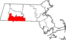 | |
| Towns | ||
| CDPs | ||
| Other villages | ||
| Footnotes | ‡This populated place also has portions in an adjacent county or counties | |