South Boston
| South Boston | |
|---|---|
| Neighborhood of Boston | |
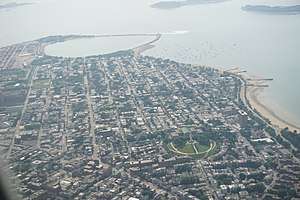
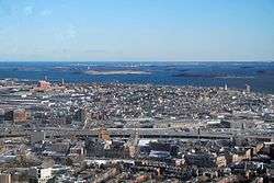 South Boston from the air | |
| Nickname(s): Southie | |
| Coordinates: 42°20′10″N 71°02′45″W / 42.33611°N 71.04583°WCoordinates: 42°20′10″N 71°02′45″W / 42.33611°N 71.04583°W | |
| Country | United States |
| State | Massachusetts |
| County | Suffolk |
| Neighborhood of | Boston |
| Annexed by Boston | 1804 |
| Population (2010) | 35,200 |
| Time zone | UTC-5 (Eastern) |
| Zip Code | 02127 |
| Area code(s) | 617 / 857 |
South Boston is a densely populated neighborhood of Boston, Massachusetts, located south and east of the Fort Point Channel and abutting Dorchester Bay. South Boston, most popularly known as Southie, was once a predominantly working class Irish Catholic community, but has become increasingly desirable among young professionals.
South Boston contains Dorchester Heights, where George Washington forced British troops to evacuate during the American Revolutionary War. South Boston has undergone gentrification, and consequently, its real estate market has seen property values join the highest in the city. South Boston has also left its mark on history with Boston busing desegregation. South Boston is also home to the St. Patrick's Day Parade, a celebration of the Irish-American culture and the Evacuation Day observance.
History

.jpg)
Geographically, Dorchester Neck was an isthmus, a narrow strip of land that connected the mainland of the colonial settlement of Dorchester with Dorchester Heights. Landfill has since greatly increased the amount of land on the eastern side of the historical neck, and widened the connection to the mainland to the point that South Boston is no longer considered separate from it. South Boston gained an identity separate from Dorchester, but the two were annexed by Boston in pieces, from 1804[1] to 1870.
During the American Revolutionary War, George Washington placed a cannon on Dorchester Heights, thereby forcing the evacuation of British troops from Boston on March 17, 1776. The British evacuated Boston and Fort William and Mary for Halifax, Nova Scotia. Fort William and Mary was replaced with a brick fortification known as Fort Independence. That fort was replaced by a granite fortification (bearing the same name) prior to the American Civil War, and still stands on Castle Island as a National Historic Landmark. Edgar Allan Poe was stationed at Castle Island for five months in 1827 and was inspired to write The Cask of Amontillado based on an early Castle Island legend.
During the 1970s, South Boston received national attention for its opposition to court-mandated school (de facto) desegregation by busing students to different neighborhoods.
In the early 21st century, property values, especially in the City Point neighborhood near Castle Island, rose to the level of some of the highest in the city. The City Point area of South Boston, labeled "East Side" by realtors, has seen a major increase in property values due to its close proximity to downtown Boston and gentrification. The "West Side" of South Boston, also known as the "lower end" by lifelong residents, though slower to begin the gentrification process also benefits from the proximity to not only downtown but also the popular South End. Additionally, the West Side is home to the first green residence (Gold LEED certified) in Boston — the Macallen Building which was featured in the movie The Greening of Southie.[2] The City of Boston is investing in the West Side through developments like the ~150,000-square-foot (14,000 m2) mixed use (residential and commercial) building being developed by the Boston Redevelopment Authority on West Broadway.
Harrison Loring House
The 1865 Harrison Loring House is a Second Empire brick mansion located in South Boston. It was used as a private residence until 1913. At that time it was purchased by the Roman Catholic Church to use the space as a convent. The house located at 789 East Broadway was designated a Boston Landmark in 1981. It is associated with Harrison Loring, who owned and operated one of the first South Boston shipyards.[3]
St. Patrick's Day Parade
The history behind the South Boston, Saint Patrick's Day Parade is General Henry Knox brought 55 cannons captured at Fort Ticonderoga. In March, the troops positioned the cannons on Dorchester Heights. They had cut down trees to cannon size, hollowed them out and blackened them over fire to look like cannons. Surprise was just around the corner. On March 17, 1776, orders were given that if you wished to pass through the continental lines, the password was "St. Patrick". The British had seen all the cannons on the Heights and left Boston.
Evacuation Day was declared a holiday in the City of Boston in 1901. In celebration, the city hosted a parade based in South Boston. A monument to the historical event was completed in Dorchester Heights in 1902. Major George F. H. Murray served as Chief Marshall for the parade in 1901. The state of Massachusetts recognized Evacuation Day as a holiday in Suffolk County (but not the rest of the state) in 1938. The Saint Patrick’s Day Parade is both a celebration of the Irish-American culture in Boston and the Evacuation Day victory. The City of Boston sponsored the event until 1947, when Mayor James Michael Curley gave authority to the South Boston Allied War Veterans Council.
Politicians and local celebrities have participated in these annual Saint Patrick’s Day Parade for years. In 1958 Senator John F. Kennedy rode with Jacqueline Kennedy in the parade. The Kennedy family were well known as participating in this parade. Robert F. Kennedy marched in 1968, Ted and Joan Kennedy also marched in 1970. The N.A.A.C.P entered a float in the Saint Patrick’s Day Parade in 1964. In the mid-1960s the Harvard’s Irish Society joined the march. Irish nationalists unofficially marched in the Saint Patrick’s Day Parade in the 1960s and 1970s. In 1972, Irish Republican Aid Committee members protested violence in Northern Ireland by carrying a coffin draped with the Irish tricolored flag. The Boston chapter of the Irish Northern Aid Commission marched with black armbands and a sign reading "England Get out of Ireland"
The year 1976 marked the 200th anniversary of Evacuation Day and the 75th anniversary of the parade. A reenactment of the 1776 evacuation was incorporated into the parade, with fireworks and period costumes. President George H.W. Bush declared March Irish-American Heritage Month in 1991. The application of the Irish American Gay, Lesbian and Bisexual Group of Boston, or GLIB, to march in the Saint Patrick’s Day Parade in 1992, the first of its kind in the history of the parade, was met with a rejection by the South Boston Allied War Veterans Council. In recent years, parade organizers have tried to make the event more kid-friendly, by incorporating "family zones" or sober places to watch the parade. The South Boston, St. Patrick’s Parade is listed as the second-largest parade in the country, being viewed by nearly 600,000 to 1 million people every year, in addition to having the entire parade seen on live television.[4][5]
In the 1990s, South Boston became the focus for a U.S. Supreme Court case on the right of gay and lesbian groups to participate in the Saint Patrick's Day (Evacuation Day) parade. The case was decided in favor of the parade's sponsors when the Supreme Court supported the South Boston Allied War Veterans' right to determine who can participate in their annual St. Patrick's Day parade.[6] In 1996 local Dorchester author Paul Walkowski and Attorney William Connolly detailed the case in their book "From Trial Court to the United States Supreme Court".[7]
Demographics
South Boston was traditionally an Irish working-class neighborhood ever since the Irish migrated to Boston due to the Great Famine that occurred in Ireland. Once a predominantly Irish Catholic community, in recent years South Boston has become increasingly desirable among young professionals and families who are attracted to the neighborhood's strong sense of community and quick access to downtown and public transportation. South Boston has a population of about 33,311.[8] The median age is about 32.[9]
The most recent census estimates South Boston's total population at 33,688. The Caucasian population is about 26,700 (79.2%). A total amount of 2,789 (8.3%) Hispanic people is counted. African American population is about 1,926 (5.7%). The Asian population makes up 4.8% (1,603). 466 people are of non-Hispanic mixed race (1.4%) and 190 people (0.6%) are identified as Others (i.e. American Indians and groups not otherwise categorized). [10]
Waterfront redevelopment

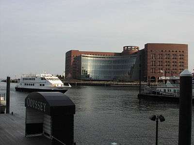
The section of South Boston north of First Street has been targeted for massive redevelopment by the administration of Mayor Thomas Menino and the Boston Planning and Development Agency (Boston Redevelopment Authority until September, 2016).[11] Initially referred to as the "Seaport District" by the BRA, this area was officially restyled the "South Boston Waterfront" after virulent protest from natives and local politicians, including City Council President James M. Kelly.[12] However, it is still also referred to as the Seaport District as of 2012.[13][14] The South Boston Waterfront area is part of the Port of Boston on Boston Harbor. While the area is not clearly defined, the Fort Point Channel forms one border and some parts of the area are also included in Fort Point neighborhood, an older, more historic term.
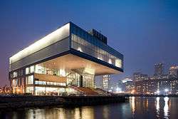
According to the Boston Seaport website, the Seaport/South Boston Waterfront has 78 restaurants, 8 hotels, and continues to grow.[15] The Boston Convention and Exhibition Center straddles D Street. The Seaport Hotel and Seaport World Trade Center is located on Commonwealth Pier. A new home for the Institute of Contemporary Art hangs over Boston Harbor just north of Northern Avenue. The John Joseph Moakley United States Courthouse is on Fan Pier.[13] The South Boston Waterfront, or The Seaport, in a massive renaissance, has exploded in recent years; considered "the hottest, fastest-growing real estate market in the country",[16] the Waterfront has seen an enormous construction boom. The "Innovation District," as ex-mayor Tom Menino termed it, is now home to tens of new office towers, residential buildings, and "innovation labs" either proposed or under construction.[17] As of September 2010, the Seaport Square project was also under planning. It was expected to cost $3 billion and replace parking lots between the federal courthouse and convention center with a 6,300,000-square-foot (590,000 m2) mixed-use development. Construction was expected to begin in 2011.[18]
The Fallon Company is currently developing Boston’s Fan Pier, one of the most sought-after waterfront sites in the United States, and a catalyst for the revitalization of South Boston’s waterfront.[19] Fan Pier is a nine-acre, 21 city block site which consisted largely of underutilized parking lots when the Fallon Company purchased it for $115 million in 2005.[20] Today, it is a neighborhood consisting of four commercial towers – One Marina Park Drive, 11 Fan Pier Boulevard, 50 Northern Avenue, and 100 Northern Avenue – and a luxury condominium tower Twenty Two Liberty.[21][22] A second residential building, Fifty Liberty, is currently under construction. Two more high-rise towers are planned. When complete in 2020, the $4 billion Fan Pier project will encompass three million square feet of commercial and residential real estate, public, civic and cultural space, including two parks and a 6-acre marina.
The Central Artery/Tunnel (CA/T) Project, also known as the "Big Dig", has created a completely new transportation network for this area.[23] The Silver Line of the MBTA provides public transportation to the area, and the Boston Harborwalk runs through it.
Due to the increase in nightlife in the neighborhood, on-street parking for residents has become increasingly scarce. In response, city officials are launching a 90-day pilot program that will expand resident only parking to seven days a week, from four. The aim, according to City Council President Bill Linehan is to address the scarcity of parking for residents on weekends.[24]
On January 13, 2016, it was announced that GE will be moving its corporate headquarters from Fairfield, Connecticut to the South Boston Waterfront. Some of the workers will arrive in the summer of 2016 and the full move will be completed by 2018. GE ranks eighth on the Fortune 500 and will become the largest publicly traded company based in Massachusetts.[25][26]
According to the Boston Globe, a two-bedroom apartment in the Seaport area can rent for more than $5,000 per month and the purchase cost would be more than $2 million in 2018.[27]
Schools
Public schools are operated by Boston Public Schools.
Public
- Excel High School
- James Condon Elementary
- Joseph P. Tynan Elementary
- Oliver Hazard Perry
- UP Academy Boston
- South Boston High School (Former)
- Samuel Adams Elementary
Private
- South Boston Catholic Academy[28]
- Saint Peters Academy
Places of worship
Catholic Churches
- Gate of Heaven Parish
The Gate of Heaven Parish was established in 1863.
- ST. Brigid Parish
The St. Brigid Parish was established in 1908.
- Our Lady of Czestochowa (Polish)
- Saint Monica – Saint Augustine (currently merged)
- Saint Peter (Lithuanian)
- Saint Vincent de Paul[29]
- Our Lady of Good Voyage[30]
- Saint Brigid
Albanian Orthodox Churches
- St George Cathedral: Located near the intersection of East and West Broadway, St George is the largest Orthodox Christian house of worship in Massachusetts. As the mother church of the Albanian diocese, the Cathedral serves as episcopal seat of Archbishop Nikon, Archbishop of Boston, New England and the Albanian Archdiocese.
- Albanian Holy Trinity Church, Kisha Shqiptare e Shen Trinise: Located at 245 D Street Boston, Massachusetts 02127.
- St John the Baptist
Episcopal
- St Matthew and the Redeemer (former)
Baptist
Presbyterian
- Fourth Presbyterian Church
Fourth Church has been a part of South Boston since 1870. Situated between two housing projects.
Parks


Shoreline of Dorchester Bay
Fort Independence, a pentagonal five-bastioned, granite fort built between 1834 and 1851, is the dominating feature of Castle Island. This 22-acre urban park is connected to the mainland by both pedestrian and vehicular causeways. Pleasure Bay, the M Street Beach and Carson Beach form a three-mile segment of parkland and beach along the South Boston shoreline of Dorchester Bay. Carson Beach offers some beautiful views and great public amenities: a rehabilitated Mothers' Rest, public restrooms, exhibit space, first aid and lifeguard functions, while the outdoor courtyards allow space for passive recreation. Carson Beach also features a walkway which allows one to walk, bike, or run along the water's edge from Castle Island to the Kennedy Library.
Fort Independence and Castle Island are on the State and National Registers of Historic Places, and the fort is a National Historic Landmark. Fort Independence is open from Memorial Day to Columbus Day, hours vary. Fort tours are conducted by the Castle Island Association in the summer months and there is interpretive signage for self-guided tours. The principal program theme, the History of Castle Island, stresses the role of the fort in harbor defense."[33]
Thomas Park
Also known as Dorchester Heights. Atop the hill sits a tall monument commemorating the Patriot battle that drove the British out of Boston.
M Street Park
Between M and N streets and north of Broadway, the M Street Park was one of the most desirable addresses in Boston in the late 19th century, and the brownstone buildings overlooking the park on the south side of the park remain some of the best examples of this style of architecture in New England. M Street Park is also home to the first standing Vietnam memorial in the nation. Included in this memorial are all the names of the South Boston residents who gave their lives fighting for the United States.
South Boston Maritime Park
Located at D Street and Northern Avenue, Boston, Massachusetts, the park is a rectangle of green lawn, gardens, trees, benches, and paved walkways. Artwork along the paths displays fish and sea motifs, paying tribute to the city’s maritime background. The roofed seating area provides partial shade and tables and chairs, an ideal spot for lunch. A seasonal café on the premises and will soon be home to Larry J's BBQ Cafe. [34]
Joe Moakley Park
This urban park features baseball and soccer fields, a spray area and a jogging track at 600 William J. Day Blvd., South Boston. Right by local transportation families have easy access in traveling to enjoy their day.
Castle Island Park
Site of Fort Independence (open in the summer) with beach, picnic and jogging area. 2010 William J Day Blvd
The Lawn on D
A lawn on 420 D Street on the east side of the Boston Convention and Exhibition Center.
Raymond L. Flynn Marine Park
Bay views, open lawn, athletic fields and a playground are features of this waterside park. Located on Farragut Road.[35]
Marine Industrial Park
This 191-acre waterfront area features businesses plus a brewery, a museum and a cruise terminal. [36]
Public housing
South Boston is home to some of the oldest public housing in the United States.[37] In the last 30 years, they have changed from having a mostly Irish-American population to a more ethnically mixed population. The housing facilities are under the control of the Boston Housing Authority (BHA)[38] and include West Broadway which was built in 1949 and occupies 20 acres (81,000 m2),[39] West Ninth Street[40] (these three facilities are next to each other and commonly called D street), Old Colony which was built in 1941,[41] and Mary Ellen McCormack, which is the BHA's oldest development, being constructed in 1936. It was originally called Old Harbor Village.[42]
Other developments are Harbor Point (in Dorchester), Foley[43] and Monsignor Powers.[44]
As of the June 26, 2014, city officials and civilians officially celebrated the completion of the second phase of construction and redevelopment of the Old Colony housing project that took place in the neighborhood of South Boston that began construction back in 2009. The phase two completion was a huge milestone because this phase included important aspects such as high-efficiency affordable housing in town-house style and four-story elevator buildings. Part of this project was funded by a HOPE VI grant which ensured $22-million for the project to build these new public houses for the citizens of South Boston, replacing 223 original apartments along Old Colony Avenue up to Dorchester Street and over to Reverend Burke Street which were demolished. These new, affordable housing units are some of the most environmentally friendly public houses in the entire Commonwealth. In the future, the Boston Housing Authority and its partners are looking to redevelop the remaining 453 original housing units in South Boston.[45]
Transportation
South Boston is served by two Massachusetts Bay Transportation Authority Red Line rapid transit stations: Broadway and Andrew. MBTA bus service links these stations to nearby residential areas via bus routes 5, 7, 9, 10, 11.
The MBTA Silver Line, a Bus rapid transit service, connects the South Boston Waterfront with South Station via a bus tunnel beneath Congress St. and Boston Logan International Airport in neighboring East Boston via the Massachusetts Turnpike and the Ted Williams Tunnel.
In popular culture
The protagonist of the 1997 film Good Will Hunting, played by Matt Damon, was a working class genius from South Boston.
The 2006 film The Departed, directed by Martin Scorsese, was inspired by the events that took place in Boston during Whitey Bulger's reign as the kingpin of the Irish Mob.
in the 2007 class-based multiplayer shooter video game Team Fortress 2, the Scout is listed as a native of South Boston
What Doesn't Kill You is a 2008 American crime drama based on the true life story of the film's director Brian Goodman, detailing his own exploits involved with South Boston's Irish Mob.[46]
The 2015 film Black Mass was inspired by the criminal activity of Whitey Bulger.
Notable people
South Boston has been the birthplace and home to a number of notable people, including:
- James "Whitey" Bulger, brother of William M. Bulger and convicted organized crime head. Was on the FBI's Ten Most Wanted list until his arrest in Santa Monica, California on June 22, 2011, and was convicted in August 2013 on 31 counts of racketeering, money laundering, extortion, and weapons charges.
- William M. Bulger, former president of the Massachusetts Senate, former president of the University of Massachusetts and brother of James "Whitey" Bulger.
- James Connolly, athlete and author who, in 1896, became the first modern Olympic champion.
- John Cunniff, National Hockey League hockey coach and former professional player who appeared in 65 World Hockey Association regular season games between 1972 and 1976.
- Richard Cushing, prelate of the Roman Catholic Church who served as Archbishop of Boston from 1944 to 1970, and was elevated to the cardinalate in 1958.
- John Ferruggio, led the evacuation of Pan Am Flight 93, in 1970.[47]
- Michael F. Flaherty, an at-large member of Boston City Council. He is a member of the Democratic Party and was elected city council president every year from 2002 to 2006.
- Raymond Flynn, Boston's mayor from 1984 to 1993 and the U.S. ambassador to the Holy See, from 1993 to 1997.
- Brian Goodman, film and television director, writer and actor.
- James Healy, America's first Catholic bishop of African descent.
- William Henry Houghton, fourth president of Moody Bible Institute, in Chicago.
- James M. "Jim" Kelly, former Boston city councilor, council president and community activist.
- George Kenneally, former pro-football player with a number of teams – most notably the Philadelphia Eagles.
- David Lindsay-Abaire, Pulitzer Prize-winning playwright and lyricist.
- Edward Lawrence Logan, National Guard general, politician, judge at South Boston District Court and namesake of the Logan International Airport
- Stephen F. Lynch, Congressman, a Democrat serving in the United States House of Representatives. Former ironworker and President of Ironworkers Local 7, State Representative and State Senator, he won his primary election to Congress on September 11, 2001.
- John William McCormack, politician who served as a member of U.S. House of Representatives from 1928 until he retired from political life in 1971. A member of the Democratic Party, he served as the House Majority Leader three times and as the Speaker of the House of Representatives from 1962 until 1971.
- Will McDonough, sportswriter for The Boston Globe and television analyst.
- Joe Moakley, U.S. congressman serving as a Democrat and the last chairman of the United States House Committee on Rules.
- Patrick Nee, former mobster and former associate of James "Whitey" Bulger.
- Brian Noonan, hockey player who won the Stanley Cup in 1994 with New York Rangers.
- John "Red" Shea, former mobster and former associate of James "Whitey" Bulger.
- Kevin Weeks, former mobster, and former lieutenant to James "Whitey" Bulger in the Winter Hill Gang, Federal witness, and author.
See also
References
Notes
- ↑ Topographical History of South Boston. 1970.
- ↑ "The Greening of Southie". greeningofsouthie.com.
- ↑ "Harrison Loring Estate" (PDF). Boston Landmark Commission.
- ↑ "Archived copy". Archived from the original on 2016-04-05. Retrieved 2016-04-27.
- ↑ Archived 2016-05-14 at the Wayback Machine.
- ↑ "U.S. Supreme Court HURLEY v. IRISH-AMERICAN GAY GROUP OF BOSTON, ___ U.S. ___ (1995)". FindLaw. 18 June 1995. Retrieved 2009-02-02.
- ↑ Walkowski, Paul; Connolly, William (April 1996). From Trial Court to the United States Supreme Court Anatomy of a Free Speech Case: The Incredible Inside Story Behind the Theft of the St. Patrick's Parade. Branden Books. ISBN 0-8283-2012-8.
- ↑ "BRA".
- ↑ "At a Glance". South Boston. Boston Redevelopment Authority. Missing or empty
|url=(help);|access-date=requires|url=(help) - ↑ "Race and Ethnicity in South Boston, Boston, Massachusetts (Neighborhood) - Statistical Atlas". statisticalatlas.com.
- ↑ "South Boston Waterfront Public Realm Plan". Boston Redevelopment Authority. October 21, 2003. Archived from the original on September 27, 2007. Retrieved 2009-02-01.
- ↑ Marantz, Steve (June 12, 1999). "Menino ends name battle with S. Boston Waterfront". The Boston Herald.
But the major stipulation is the "South Boston Waterfront" name, a priority of City Council President James M. Kelly, who objected to the Seaport District appellation used in printed documents of the Boston Redevelopment Authority.
- 1 2 Vogel, Chris; and Patrick Doyle and Matthew Reed Baker (July 2012). "The Rise of the Seaport". Boston Magazine. Retrieved 26 March 2013.
- ↑ Chesto, Jon (2012-04-17). "The South Boston waterfront gets a new website – and another new name". Mass. Market. Archived from the original on 27 May 2013. Retrieved 26 March 2013.
- ↑ "Map Of Places - Boston's Seaport Neighborhood". Seaport. Retrieved 2017-10-04.
- ↑ Acitelli, Tom. "On Southie Becoming South Boston". Curbed. Retrieved 18 June 2014.
- ↑ Various. "Seaport Square". Curbed. Retrieved 18 June 2014.
- ↑ "Seaport makeover to begin next year". Boston Metro, 23 September 2010, p 3.
- ↑ Cortese, Amy (October 7, 2007). "From Empty Lots to Bustling Waterfront". The New York Times.
- ↑ C. Palmer, Jr., Thomas (December 18, 2005). "The Dreamer". The Boston Globe Magazine (“Bostonian of the Year”).
- ↑ Chesto, Jon (June 9, 2015). "With unusual sales plan, Fan Pier luxury units sell out". The Boston Globe.
- ↑ Baskin, Kara (July 2015). "Views Included". Boston Magazine.
- ↑ James M. Kelly, long-time city councilor and South Boston icon, dies. Boston Globe, January 9, 2007.
- ↑ Ryan, Andrew. "South Boston skeptical of parking changes". www.bostonglobe.com. The Boston Globe. Retrieved 11 August 2014.
- ↑ "Boston lands new GE headquarters". Boston Globe. Retrieved January 13, 2016.
- ↑ Mann, Ted; Kamp, Jon (2016-01-13). "General Electric to Move Headquarters to Boston". The Wall Street Journal. Retrieved 2016-01-13.
- ↑ Ryan, Andrew (2017-12-11). "A Brand New Boston Even Whiter Than The Old". The Boston Globe. Retrieved 2017-12-14.
- ↑ "Life at SBCA - South Boston Catholic Academy".
- ↑ "Archdiocese of Boston Parishes, Schools and People". bostoncatholic.org.
- ↑ "Boston Seaport | Chapel of Our Lady of Good Voyage". Seaport. Retrieved 2017-10-04.
- ↑ Cf. Sammarco (2006), p.25
- ↑ History of the South Baptist Church, Boston, Boston : Alfred Mudge & Son, 1865.
- ↑ "Mass.gov".
- ↑ "Archived copy". Archived from the original on 2016-05-13. Retrieved 2016-04-27.
- ↑ "Artucle". bostonredevelopmentauthority.org.
- ↑ "South Boston".
- ↑ Boston Connects. South Boston Archived September 28, 2006, at the Wayback Machine.
- ↑ "Welcome to the Boston Housing Authority". Boston Housing Authority. Archived from the original on 2009-01-29. Retrieved 2009-02-01.
- ↑ "West Broadway". Boston Housing Authority. Archived from the original on 2001-06-24. Retrieved 2009-02-01.
- ↑ "West Ninth Street". Boston Housing Authority. Archived from the original on 2009-04-01. Retrieved 2009-02-01.
- ↑ "Old Colony". Boston Housing Authority. Archived from the original on 2009-02-18. Retrieved 2009-02-01.
- ↑ "Mary Ellen McCormack". Boston Housing Authority. Archived from the original on 2009-03-21. Retrieved 2009-02-01.
- ↑ "Foley". Boston Housing Authority. Archived from the original on 2008-12-05. Retrieved 2009-02-01.
- ↑ "Monsignor Powers". Boston Housing Authority. Archived from the original on 2008-12-05. Retrieved 2009-02-01.
- ↑ "City and state officials celebrate completion of 129 new apartments at Old Colony". Boston Housing Authority. Retrieved 26 April 2015.
- ↑ "Exclusive: Brian Goodman Faces What Doesn't Kill You". comingsoon.net. 2008-12-10. Retrieved 2018-01-28.
- ↑ Marquard, Bryan (2010-06-22). "John Ferruggio, at 84; hero of 1970 Pan Am hijacking". Boston Globe. Retrieved 2010-06-27.
Sources
- Sammarco, Anthony Mitchell; Rosenberg, Charlie, South Boston: Then & Now, Arcadia Publishing Company, 2006
Further reading
- Charles Bancroft Gillespie (1900), Illustrated history of South Boston, South Boston, Mass: Inquirer Pub. Co.
- Malloy, Ione (1 October 1986). Southie Won't Go: A Teacher's Diary of the Desegregation of South Boston High School. University of Illinois Press. ISBN 0-252-01276-3.
- O'Connor, Thomas (24 February 1994). South Boston, My Home Town: The History of an Ethnic Neighborhood. Northeastern University Press. ISBN 1-55553-188-1.
- Anthony Mitchell Sammarco (1996), South Boston, Images of America, Dover, N.H.: Arcadia, OL 1657075W
- Alcorn, Frank (7 October 2005). Southie Boy. Cork Hill Press. ISBN 1-59408-054-2.
- Weeks, Kevin; Karas, Phyllis (10 March 2006). Brutal: The Untold Story of My Life Inside Whitey Bulger's Irish Mob. William Morrow. ISBN 0-06-112269-6.
- MacDonald, Michael Patrick (4 October 2007). All Souls: A Family Story from Southie. Beacon Press. ISBN 0-8070-7213-3.
- Born before plastic: stories from Boston's most enduring neighborhoods; North End, Roxbury, and South Boston, Boston, Massachusetts, USA: City of Boston and Grub Street, Inc., 2007
External links
| Wikimedia Commons has media related to South Boston. |
| Wikivoyage has a travel guide for South Boston. |
- South Boston Online
- South Boston Tribune
- Southie's St Patrick's Day Parade
- Boston Public Library. Boston Pictorial Archive. Images of South Boston
- "South Boston". Boston TV News Digital Library. WBGH. 1960–2000.