Massachusetts Route 203
| ||||
|---|---|---|---|---|
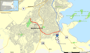 Map of Suffolk County in eastern Massachusetts with Route 203 highlighted in red | ||||
| Route information | ||||
| Maintained by MassDOT | ||||
| Length | 5.34 mi[1] (8.59 km) | |||
| Existed | early 1970s – present | |||
| Major junctions | ||||
| West end | Centre Street in Boston | |||
|
| ||||
| East end |
| |||
| Location | ||||
| Counties | Suffolk | |||
| Highway system | ||||
| ||||

Route 203 is a 5.5-mile (8.9 km) state-numbered route in Boston, Massachusetts, United States, running from old U.S. Route 1 in Jamaica Plain east to Interstate 93/U.S. Route 1/Route 3 and Route 3A at Neponset. It runs along the Arborway, Morton Street and Gallivan Boulevard, all parkways formerly part of the Metropolitan District Commission system of parks and roads.
Maintenance
Prior to the creation of the Massachusetts Department of Transportation (MassDOT) in 2009, the route was owned and maintained by the Department of Conservation and Recreation (DCR, previously the Metropolitan District Commission). On November 1, 2009, the Msgr. William Casey Highway overpass in Jamaica Plain, Morton Street in Mattapan and Gallivan Boulevard in Dorchester were transferred to MassDOT, while the Arborway continued under DCR.[2][3]
History
Route 203 was formed in the early 1970s as part of a large Boston-area renumbering. Most of the route had been part of Route 3, which came south along The Jamaicaway with U.S. Route 1 and split to the east along present Route 203. Route 3 turned south at Granite Avenue to join the Southeast Expressway in Milton, and Route 3A began where Route 3 turned. With the renumbering, Route 3 was kept on the Southeast Expressway into downtown, Route 3A was truncated to its current end, and the former Route 3 and Route 3A became Route 203. While the former routes had been signed north–south, the new route was signed east–west.
The only other change has been the removal of U.S. Route 1 from the west end of Route 203; it no longer ends at a numbered route at its west end.
Major intersections
The entire route is in Boston, Suffolk County. [1]
| mi[1] | km | Destinations | Notes | ||
|---|---|---|---|---|---|
| 0.000 | 0.000 | Centre Street | |||
| 2.581 | 4.154 | ||||
| 5.34 | 8.59 | ||||
| 1.000 mi = 1.609 km; 1.000 km = 0.621 mi | |||||
References
- 1 2 3 MassDOT Planning Division. "Massachusetts Route Log Application". Massachusetts Department of Transportation. Retrieved September 20, 2014.
- ↑ "Chapter 25 of the Acts of 2009 (Section 177)". The 186th General Court of The Commonwealth of Massachusetts. Retrieved 2009-11-05.
- ↑ Pazzanese, Christina (September 12, 2009). "A big concern on two major parkways". The Boston Globe. Retrieved 2009-11-05.