The Berkshires
| The Berkshires | |
|---|---|
| Region of Massachusetts and Connecticut | |
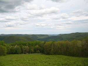 A view of the Berkshires from near North Adams, Massachusetts | |
| Country | United States |
| States | Massachusetts and Connecticut |
| Berkshires | |
|---|---|
| Berkshire Hills, Berkshire Mountains | |
 | |
| Highest point | |
| Peak | Crum Hill |
| Elevation | 2,841 ft (866 m) |
| Coordinates | 42°42′40″N 73°01′11″W / 42.71111°N 73.01972°W |
| Dimensions | |
| Length | 98 mi (158 km) north-south |
| Geography | |
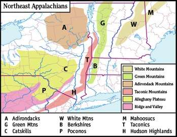 Berkshires labeled as B
| |
| Country | United States |
| State | Massachusetts and Connecticut |
| Range coordinates | 42°10′0.325″N 73°8′58.385″W / 42.16675694°N 73.14955139°WCoordinates: 42°10′0.325″N 73°8′58.385″W / 42.16675694°N 73.14955139°W |
| Geology | |
| Type of rock | Metamorphic |
The Berkshires (locally /ˈbɜːrkʃɪərz,
Also referred to as the Berkshire Hills, Berkshire Mountains, and Berkshire Plateau, the region enjoys a vibrant tourism industry based on music, arts, and recreation. Geologically, the mountains are a range of the Appalachian Mountains.
The Berkshires were named among the 200 Last Great Places by The Nature Conservancy.[2][3]
Definition
The term "The Berkshires" has overlapping but non-identical political, cultural, and geographic definitions.
Political
Politically, Berkshire County, Massachusetts, was formed as a governing body in 1761; it includes the western extremity of the state, with its western boundary bordering New York and its eastern boundary roughly paralleling the watershed divide separating the Connecticut River watershed from the Housatonic River-Hoosic River watersheds.
Cultural
Culturally, the term "Berkshires" includes all of the highland region in western Massachusetts west of the Connecticut River and lower Westfield River, and (under the name "Litchfield Hills") all of northwest Connecticut from the Farmington River valley in the northern part of the state in a diagonal arc west to Winsted and Litchfield, then southwest to Lake Candlewood on the New York border and ending in Ridgefield, Connecticut. The cultural region also includes the Taconic Mountains bordering New York, which are geologically distinct from the Berkshires orogeny. Southwest Vermont and the Taconic region of New York are occasionally grouped with the Berkshires cultural region.
Sir Francis Bernard, the royal governor (in office 1760-1769), named the area "Berkshire" to honor his home county in England.
Geographic
Geologically and physically, the Berkshires are the southern continuation of the Green Mountains of Vermont, distinct from them only by their lower average elevation and by virtue of what side of the border they fall on. In physical geography, the Berkshires extend from the Housatonic River and Hoosic River valleys in western Massachusetts, to the Connecticut River valley in north-central Massachusetts, and to the foot of the lower Westfield River valley in south-central Massachusetts. In Connecticut, where they are referred to as the Litchfield Hills, they extend from the upper Housatonic River valley in the northwest part of the state, south along the western border of the state, east to the Farmington River valley in north-central Connecticut, south to the Quinnipiac River valley in central Connecticut, then southwest to the Housatonic River valley in southwest Connecticut.
Geologically, the Berkshires are bordered on the west by the Taconic Mountains, the marble valleys of the Hoosic River and Housatonic River and, further south, by the Hudson Highlands; to the east, they are bordered by the Metacomet Ridge geology. They are on the average 1,000 ft (300 m) lower and less prominent than the Green Mountains of Vermont, and form a broad, dissected plateau punctuated by hills and peaks and cut by river valleys. The Berkshires topography gradually diminishes in profile and elevation from west to east and from north to south, except where rivers have cut deep gorges and sharp bluff faces into the Berkshire plateau.
Formation
The Berkshires and related Green Mountains formed over half a billion years ago when Africa collided with North America, pushing up the Appalachian Mountains and forming the bedrock of the Berkshires. Erosion over hundreds of millions of years wore these mountains down to the hills that we see today.[4]
Elevation
The average regional elevation of the Berkshires ranges from about 700 to 1,200 feet (210 to 370 m). One of the high points is Spruce Mountain, at 2,710 feet (830 m). The highest point in the Berkshires physiographic region is Crum Hill, 2,841 feet (866 m), in the town of Monroe; however, nearby Mount Greylock of the Taconic Mountains, at 3,491 feet (1,064 m) the highest point in the state of Massachusetts, is considered the high point of the Berkshires cultural region.
Rivers
The Housatonic River, Hoosic River, Westfield River, and Deerfield River watersheds drain the Berkshires region in Massachusetts; in Connecticut the main river drainages are the Farmington River, the Naugatuck River, the Shepaug River, and the Housatonic River.
Counties
The Berkshire mountain range runs through:
- Berkshire County, Massachusetts (all towns)
- Hartford County, Connecticut (Hartland, Granby)
- Franklin County, Massachusetts (western part)
- Hampden County, Massachusetts (Tolland, Chester, Granville, Blandford)
- Hampshire County, Massachusetts (western part)
- Litchfield County, Connecticut (all towns)
Municipalities
The largest municipalities associated with the Berkshires cultural region include Pittsfield, North Adams, Great Barrington, Williamstown, Stockbridge, Lee, and Lenox, Massachusetts.
History
During the American Revolution a Continental Army force under Henry Knox brought captured cannons from Fort Ticonderoga by ox-drawn sleds south along the west bank of the Hudson River from the fort to Albany, where he then crossed the Hudson. Knox and his men continued east through the Berkshires and finally arrived in Boston. This feat, known as the "Noble train of artillery", was accomplished in the dead of winter, 1775-1776.
Ecology
The Berkshires lie within the New England/Acadian forests ecoregion.[5]
Similarly, the U.S. Environmental Protection Agency in Massachusetts (Griffith et al. 1994) has defined six ecoregions within this area: Taconic Mountains, Western New England Marble Valleys, Lower Berkshire Hills, Berkshire Highlands, Vermont Piedmont, and Berkshire Transition. Each region is distinct from the others, providing a unique habitat assemblage.
Much of the Hoosic and Housatonic River valleys have underlying bedrock limestone and marble which contribute to calcareous wetlands unique in Massachusetts. The alkaline pH waters support a diversity of plants and animals intolerant of more acidic waters, some of which are state-listed rare or endangered. Combined with the rich mesic forests ranging from the northern hardwood to the taiga or sub-alpine, the Berkshires have a valuable, biologically diverse ecosystem.
The classic study of the vegetation of the Berkshire Highlands was Egler's 1940 monograph,[6] covering the flora of an area stretching roughly from Pittsfield, Massachusetts, in the west to Hatfield, Massachusetts, in the east, and from Goshen, Connecticut, in the south to the Vermont border in the north.
Today, efforts are being made by many organizations to preserve and manage this region for biological diversity and sustainable human development. See also: Natural History of the Berkshires.
Tourism
The Berkshires have numerous trails, including part of the Appalachian Trail, large tracts of wilderness and parks like Kent Falls, the tallest waterfall in Connecticut, Berkshire Botanical Garden and Hebert Arboretum The area includes Bash Bish Falls, the tallest waterfall in Massachusetts.
The Berkshire region is noted as a center for the visual and performing arts; its art museums include the Norman Rockwell Museum, the Clark Art Institute, the Massachusetts Museum of Contemporary Art (Mass MoCA), and the Williams College Museum of Art (WCMA). Performing-arts institutions in the Berkshires include Tanglewood Music Center and Boston University Tanglewood Institute in Lenox, the summer home of the Boston Symphony Orchestra; the Bang on a Can Summer Festival for contemporary music in North Adams; Shakespeare & Company in Lenox; summer stock theatre festivals such as the Williamstown Theatre Festival in Williamstown, Barrington Stage Company in Pittsfield, and the Berkshire Theatre Festival in Stockbridge; and America's first and longest-running dance festival, Jacob's Pillow, in the town of Becket.
See also
References
- ↑ "Berkshire Hills". Geographic Names Information System. United States Geological Survey. Retrieved 2009-05-03.
- ↑ McDonald, Martha (June 2010). "Winsome Twosome". Traditional Building Magazine. Retrieved March 28, 2015.
- ↑ "Where We Work > Regions > North America > Areas > Berkshire Taconic Landscape". The Nature Conservancy. Retrieved March 29, 2015.
- ↑ Raymo, Chet and Raymo, Maureen E. Written in Stone: A Geologic History of the Northeastern United States. Globe Pequot, Chester, Connecticut, 1989.
- ↑ Olson, D. M, E. Dinerstein; et al. (2001). "Terrestrial Ecoregions of the World: A New Map of Life on Earth". BioScience. 51 (11): 933–938. doi:10.1641/0006-3568(2001)051[0933:TEOTWA]2.0.CO;2. Archived from the original on 2011-10-14.
- ↑ Egler, F. E. 1940. "Berkshire Plateau Vegetation, Massachusetts". Ecological Monographs 10:147-192.
External links
| Wikivoyage has a travel guide for Berkshire Hills. |