East Boston
| East Boston | |
|---|---|
| Neighborhood of Boston | |
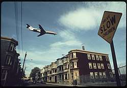 An airplane approaching Logan International Airport in 1973. | |
| Nickname(s): Eastie, EBO | |
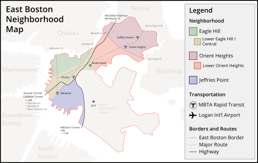 Neighborhood map of East Boston, Massachusetts | |
| Country | United States |
| State | Massachusetts |
| County | Suffolk |
| Neighborhood of | Boston |
| Annexed by Boston | 1836 |
| Population (2010) | 40,508 |
| Time zone | UTC-5 (Eastern) |
| Zip Code | 02128, 02228 |
| Area code(s) | 617 / 857 |
| Website |
www |
East Boston, nicknamed Eastie, is a neighborhood of Boston, Massachusetts with over 40,000 residents. The neighborhood was created by connecting several islands using land fill. It was annexed by Boston in 1836. It is separated from downtown Boston by Boston Harbor and bordered by Winthrop, Revere, and the Chelsea Creek. Directly west of East Boston, across Boston Inner Harbor, is the North End and Boston's Financial District. The neighborhood is easily accessible to downtown Boston via the MBTA Blue Line.
East Boston has long provided a foothold for the latest immigrants with Irish, Russian Jews and later, Italians.[1] John F. Kennedy's great grandfather was one of many Irish people to immigrate to East Boston, and the Kennedy family lived there for some time.
From the 1990s into the early millennium, Latin American immigrants settled in East Boston, eventually composing more than fifty percent of the population in the 2010 neighborhood census.[2] In recent years, East Boston has become home to a wave of young professionals seeking residence in Boston in newly renovated condominiums along Jeffries Point, Maverick Square, and the Eagle Hill waterfront, ushering in gentrification. Originally, five islands[3] made up the East Boston neighborhood. To connect to the mainland to the north, fill was mostly used. Logan International Airport is located in East Boston, connecting Boston to domestic and international locations.[4]
History
Early history
The landmass that is East Boston today was originally made up of five islands: Noddle's; Hog's (which later known as Breed's Island, and would become Orient Heights); Governor's; Bird; and Apple. Not long after Boston was settled, Noddle Island served as grazing land for cattle.[5]
Originally, people used ferries to get from East Boston to downtown. They were eventually replaced by the streetcar tunnel that became the MBTA Blue Line. Additionally, the five islands were connected using landfill, the latter three during the expansion of Logan Airport during World War II.
In 1801, William H. Sumner had proposed to the federal government of the United States to create a turnpike to connect Salem to Boston via the undeveloped Noddle's Island. He argued that the road would create a much more direct route, making it easier for the neighborhood to develop. He stated
... in my opinion that the circular route from Chelsea thro' Charlestown to Boston is about 1 of a mile farther than a direct course over Noddle's Island in Boston ... The course suggested will be almost in a direct line, from my knowledge of the land ... On the back part of the Island is a muddy creek and the distance of the Island to Boston is not so great by one third, I presume as it is from Chelsea to Moreton Point in Charlestown ... There is no doubt that but that the necessities of the town of Boston will some require a connection with Noddle's Island with the town of which it is part.[6]
The one issue that Sumner foresaw, but glossed over, was that land in Charlestown was purchased by the federal government as the site for a future naval yard. The ships en route from this yard to the ocean would be blocked by the proposed turnpike. Sumner believed this would not stand in his way, since a standing navy was in such disfavor at that point in the nation's history. However, the War of 1812, which was considered a naval war, changed the public's opinion about the needs for a naval yard. Because the route through East Boston and over the Boston Harbor would block ships route to the future Charlestown Navy Yard the turnpike was planned to go through Chelsea as opposed to Noddle's Island.
Formation of East Boston Company
Sumner began to make his move for the acquisition of all of Noddle's Island upon the death of Colonel David Stoddard Greenough, who had been a longtime holdout against selling to him. Greenough died of apoplexy, and his wife and children wanted to cede their portion of the island. In 1836, Sumner coincidentally married Greenough's widow, Maria Foster Doane.[7] With the assistance of his new business partners, Steven White and Francis J. Oliver, he purchased the land for $100 per acre or $32,500. This purchase gave Sumner control of one half of the Island. Subsequently, in February 1832, the partners formed the East Boston Company. They stated that their part of the Island was to be divided into 666 shares and that it would be managed by a board of directors, who would be able to sell the Company's interest in the island. Establishing transportation to the area was imperative and they were dedicated to pushing for a railroad connection from Boston to Salem over the Island. They also wanted to establish a ferry system from Boston. Each share of the Company was equivalent to 0.5-acre (2,000 m2). There were 5,280 acres in total, of which Sumner owned 1320; Mrs. Gerard, 880; Steven White, 880; and Oliver, 440. The rest were spread among twenty-nine other shareholders. By the end of 1833, the East Boston Company had complete control over the entire Island.
Connections to the mainland

In the 1830s, the largest problem keeping East Boston from thriving was transportation. The East Boston Company believed the neighborhood could not become a valuable asset until people had a way to reach the area from the Boston mainland. As a temporary solution, they set up a paddle steamer to carry 15 people at a time from Boston Proper to the neighborhood. It was used primarily for occasional visits from public officials and laborers. Though they did not have the ridership to support additional boats, the company purchased the Tom Thumb steamboat.
The steam railroad system was still in its infancy at this point, and the East Boston Company was approached by an inventor of a new type of rail system, the suspension railway. This system was one of the earliest suspended railroads to be built. The railroad cars were propelled by a steam engine hanging from a suspended track. Henry Sargent, the inventor, stated "that his invention would make the Island a center of attraction to many people." The Company allowed it to be built on its land and it was in use for nine days in 1834, then closed citing lack of ridership.
In the mid-1830s, the Company made several investments to further East Boston's development. They continued attempts to get the Eastern Railroad to come to East Boston. The Maverick and East Boston ferries began service from Lewis Wharf on the mainland to East Boston. A bridge to Chelsea was built, roads were laid out, and houses were built. Much of this activity was spurred by the formation of the East Boston Lumber Company. During this period, the Boston Sugar Refinery was also founded, which was the first manufacturing establishment in East Boston. They are credited for the creation of white granulated sugar.[8]
Kennedy family
When my great grandfather left here to become a cooper in East Boston, he carried nothing with him except two things: a strong religious faith and a strong desire for liberty. I am glad to say that all of his great grandchildren have valued that inheritance.
— President Kennedy addressing the people of New Ross, Ireland, June 1963
The Kennedy Family lived on Meridian Street in what is now a small home wedged between a Hispanic market and hardware store, approaching the Meridian Street branch of the Boston Public Library. The family later moved to a larger home on Monmouth Street. P. J. Kennedy's success enabled him to purchase a home for his son, Joseph, and another for his two daughters at Jeffries Point.
In 1954, John F. Kennedy famously paraded through East Boston with his wife, Jackie, in anticipation for his campaign to run for United States Senate, to secure votes from the neighborhood. In a famous photograph, Kennedy is shown walking down Chelsea Street heading towards Maverick Square, waving to the crowd in front of Santarpio's Pizza.[9]
On numerous occasions throughout his career in the United States Senate, Senator Ted Kennedy mentioned that his family's roots are embedded in East Boston.
Later history
Since the mid-19th century, the community has served as a foothold for immigrants to the United States: Irish and Canadians came first, followed by Russian Jews and Italians, then Southeast Asians, and, most recently, a large influx from Central and South American countries.[1] The Orient Heights section of East Boston was the first area in Massachusetts to which Italians immigrated in the 1860s and 1870s, and today the heart of the Italian community remains in East Boston.
The population of East Boston, which was recorded as a mere thousand in 1837, exploded to a high of just over 64,000, according to the 1925 census. The sudden rise is attributed to the immigrants who came from Southern Italy. Today, the neighborhood is home to over 40,000 inhabitants, with a median income per household of around $46,000.[10][11]
Transportation
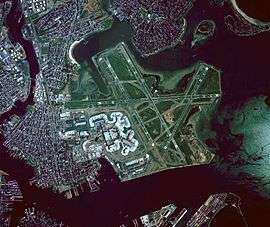
Transportation has long played a role in the shaping of East Boston. Clipper ships were built at the shipyard owned by Donald McKay in the mid-19th century. A subway tunnel connecting the neighborhood to the rest of the city opened in 1904 and was the first undersea tunnel of its kind in the United States. Rows of houses were torn down to build the Sumner Tunnel in 1934 and the Callahan Tunnel in 1961, directly connecting automobile traffic from downtown Boston. In the early 1920s, an airfield was built, and eventually it was expanded to become Logan International Airport. The eastern terminus of Interstate 90 (the Massachusetts Turnpike) has been at Route 1A next to Logan Airport since 2003, and the newer Ted Williams Tunnel (1995) links I-90 from East Boston to the rest of the city.
Logan Airport, New England's primary international airport and 48th busiest in the world, resides mainly in East Boston (though part of the airfield itself lies in Winthrop). There has been continual controversy surrounding Logan, as constant conflict with the Massachusetts Port Authority has been a source of bitterness among some local residents since its inception. One expansion of the Airport resulted in the loss of Wood Island Park, a green space designed by the noted landscape architect Frederick Law Olmsted. The expansion of Logan Airport in the late 1960s and early 1970s displaced families along Neptune Road, which is now used for warehouses and rental car property. The airport has since implemented four "airport edge buffers," which include parks and greenery to appease residents.[12]
The MBTA's Blue Line stops in East Boston include Maverick, Airport, Wood Island, Orient Heights, and Suffolk Downs. Massport provides free shuttle buses from the Airport MBTA station to all Logan Airport terminals and the Rental Car Center. The East Boston Greenway, a shared use path and park along a former rail line, connects to the Airport station.
Demographics
.jpg)
East Boston's population is ethnically diverse, reflecting the immigrants from around the world who moved there. Since the early 1900s, immigrants have been a part of the East Boston community. First Irish and Canadians, then Russian Jews and Italians, Southeast Asians, and finally Latinos. In 2011, East Boston was estimated to have 41,128 residents living in 14,832 housing units.[13]
Hispanic/Latino people speaking Spanish or Portuguese are the largest language groupings (can be of any race and from more than 20 countries), making up 54.4% of the population, followed by non-Hispanic white (35.5%). Other races include Asian (4.4%), black or African American (2.9%), biracial or multiracial individuals (1.9%), and other races (0.9%).
The median household income for an individual in East Boston was $45,849, while the median income for a family was $47,198.[13]
Housing
Up until 2011 there were a total of 16,090 housing units in East Boston. Of these, 14,832 were occupied and 1,258 were vacant. Out of the 14,832 occupied units, 4,248 were owner-occupied and 10,584 were renter-occupied. The median gross rent was $1,092.[14]
Homelessness is an issue in the shelters and on the streets of East Boston. To help families transition out of East Boston's homeless shelter, the City of Boston, Crossroads Family Shelter, and the East Boston Community Development Corporation joined together in 2015 create subsidized housing on Havre Street. There are seven new affordable units planned.[15]
Gentrification
Rising rents are an issue for some residents in East Boston. Recent renovations to much of the condominium and apartment rental properties in East Boston have resulted in demands for higher rents, forcing mostly uneducated low-income residents to move.[16] The influx of educated professionals has resulted in renewed interest in East Boston historical housing stock, and many buildings are being restored after years of neglect.
Sites of interest
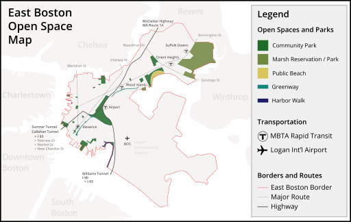
Belle Isle Marsh Reservation
The largest remaining salt marsh in Boston, the 350-acre (1.4 km2) Belle Isle Marsh Reservation, lies in East Boston. The marsh also borders the towns of Revere and Winthrop. It was once a Metropolitan District Commission reservation, but it is now run by the Massachusetts Department of Conservation and Recreation. It is a reserve for a variety of flora and fauna.
Community gardens
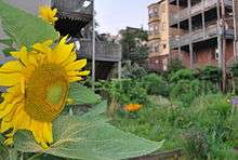
East Boston is home to six community gardens, managed by various organizations such as the Boston Parks and Recreation Department and the Boston Natural Areas Network.[17] Participating gardeners at some of the gardens are assigned small plots which they may plant as they like, in exchange for a nominal annual dues payment. Other gardens, such as "Nuestro Jardín" ("Our Garden") across from the Umana School, was formerly reserved for use by schoolchildren, but is now maintained by a community-based youth program.
Constitution Beach
Located in Orient Heights is one of Boston's more popular public beaches, Constitution Beach. The easternmost portion of the beach is known to locals as "Shay's Beach." The beach underwent renovations in the late 1990s as a new public bathhouse and refreshment stand was added, as well as a new pedestrian walkway over the tracks of the Blue Line onto Bennington Street. The East Boston Greenway was recently connected to the beach by the creation of a multi-use path from Wood Island.
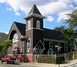
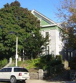
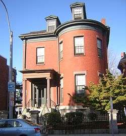
Historic places
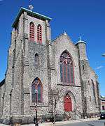
East Boston has eight places on the National Register of Historic Places.
Piers Park
.jpg)
Piers Park is located on the west side of East Boston, overlooking Boston Harbor and downtown Boston. Designed by Pressley Associates Landscape Architects of Cambridge, the 6.5-acre park was conceived to reclaim a former pier to allow the neighborhood direct access to its waterfront. The park consists of multiple trails paved in brick and granite from the pier's original 1870 seawalls; native salt-tolerant New England plants; more than thirty-two tree varieties; seasonal flowers; ornamental shrubs; and a 600-foot meandering brick pedestrian promenade with four smaller shade pavilions.[18] One of the pavilions is dedicated to Donald McKay.
There is also a play area and spray pool for children; a small exercise station; an amphitheater; and a community boating program, Piers Park Sailing Center.[19]
Suffolk Downs
Suffolk Downs, opened in 1935, is a thoroughbred race track located in East Boston. For years, Suffolk Downs has held a Grade II race event at the track called the MassCap. Because of declining revenues as result of growing Indian Casinos in Rhode Island and Connecticut, Suffolk Downs canceled the 2009 MassCap.[20]
On August 18, 1966, the Beatles played a concert before approximately 24,000 people in the infield of the race track.
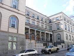
Government and business
.jpg)
East Boston is the headquarters for District A-7 of the Boston Police Department. The Boston Fire Department has three fire stations in East Boston: Ladder 2 & Engine 9 in Maverick Square; Engine 5 in Day Square; and Ladder 21 & Engine 56 in Orient Heights.
Boston EMS's Station 7 is based at Logan Airport, but provides emergency medical services to all of East Boston.[21]
The United States Postal Service operates a branch in East Boston at 50 Meridian Street.[22]
The Logan Office Center, which contains the headquarters of the Massachusetts Port Authority, is adjacent to Logan Airport.[23]
Education
Public libraries
.jpg)
The first public branch library in the United States was established in East Boston in 1870.[1] Boston Public Library currently has one location in East Boston, at 365 Bremen Street in the Bremen Street Park. This branch opened in November 2013. The old branches at 276 Meridian Street and 18 Barnes Avenue were closed in 2013, shortly before the current branch opened.
Primary and secondary schools
Public schools
Boston Public Schools operates numerous schools in East Boston.[24] BPS assigns students based on student preference and priorities of students in various zones. Due to the geography of East Boston, every child in the neighborhood is guaranteed a seat at a school in East Boston. The district instructs parents wanting to send their children to East Boston schools to place East Boston campuses on their school assignment priority lists higher than non-neighborhood campus.[25]
East Boston Early Childhood Center is a district K0–1 school in East Boston. District elementary schools include Samuel Adams, Manassah E. Bradley, Curtis Guild, Patrick J. Kennedy, Hugh R. O'Donnell, and James Otis.
Mario Umana Academy and Donald McKay K-8 School are the two district K–8 schools in East Boston. East Boston High School is the sole district public high school in East Boston.
Excel Academy Charter School, a charter middle school, is located on Moore St. in East Boston.[26]
.jpg)
.jpg) Samuel Adams Elementary School
Samuel Adams Elementary School.jpg) Manassah E. Bradley Elementary School
Manassah E. Bradley Elementary School.jpg) Curtis Guild Elementary School
Curtis Guild Elementary School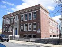 Patrick J. Kennedy Elementary School
.jpg) Donald McKay K-8 School
Donald McKay K-8 School.jpg) Hugh R. O'Donnell Elementary School
Hugh R. O'Donnell Elementary School.jpg) James Otis Elementary School
James Otis Elementary School
Private schools
In spring 1892, a school named after Fr. James Fitton was dedicated on the Holy Redeemer site. In 1974, a school merger occurred, producing the current East Boston Central Catholic School.[27] The Roman Catholic Archdiocese of Boston operates East Boston Central Catholic School on the Most Holy Redeemer Parish site. It is a K1–8 private school in East Boston. The school is managed by a board from the Our Lady of the Assumption, Our Lady of Mount Carmel, Most Holy Redeemer and Sacred Heart parishes.
In Spring 2008, the Archdiocese ordered the closure of St. Mary, Star of the Sea School, a K–8 school in East Boston. The parish attached to the school had closed three years prior to the closure of the school.[28]
Until it closed in 2007, Savio Preparatory High School was a private, coeducational high school in East Boston.[29]
Community resources
East Boston has a wide variety of community resources, both not-for-profit and government-funded.
Community centers
The City of Boston runs two community centers in East Boston: Orient Heights Community Center (now called The Marcintino Community Center) and Paris Street Community Center.[30] These Centers are an initiative of a citywide organization called Boston Center for Youth and Families.[31] The Centers aim to assist local youth with after-school programming.
Open space
In the early 1990s, East Boston had the least open space of any Boston neighborhood, except Chinatown. However, the city of Boston, and East Boston in particular, has undergone several major initiatives to increase open space in Boston. One such initiative is called Urban Wilds. Unveiled in 2016, it focuses on protecting "urban wilds" in Boston's neighborhoods. The city has identified four sites in Boston which it is targeting to improve coastal habitats, rejuvenate fish populations, restore soil, and use for flood control and water quality improvement purposes.[32]
The city's creation of the East Boston Greenway, which stretches from the wharfs at Maverick Square to the Bayswater Urban Wild, has also been a major addition to the neighborhood's green space.
Today, East Boston has 230 acres of protected open space, and 371 acres of total open space. This averages out to 5.98 acres of protected space per thousand individuals. This is less than the citywide average of 7.43 acres per thousand people.[33]
Maps
|
|
|
Notable people
See also People from East Boston, Boston
- Benjamin A. Botkin, scholar and folklorist
- Thomas J. Buckley, 18th Massachusetts Auditor
- John J. Douglass, member of the United States House of Representatives from 1925–1933
- Frank Greer, rower and Olympic gold medalist
- Helen Johns, swimmer and Olympic gold medalist
- Jeff Kalligheri, Hollywood Film & Television Producer including such notable films as SUBMERGENCE, DEPARTED, THE LETTER, HUNTSVILLE, HAPPY HUNTING, & BACKSTABBING FOR BEGINNERS [34][35][36]
- Augie Lio, former American football player and member of the College Football Hall of Fame
- Frederick Mansfield, 46th Mayor of Boston
- James O'Grady, Founder of the Boston Typewriter Orchestra
- William Matthew Prior, noted painter
- Gene Sharp, scholar
- Robert Travaglini, 93rd President of the Massachusetts Senate
- Jermaine Wiggins, former American football player and Super Bowl XXXVI champion
- John L. Bates, 41st Governor of Massachusetts
- P.J. Kennedy, Massachusetts politician and grandfather of U.S. President John F. Kennedy.
See also
References
- 1 2 3 "East Boston". City of Boston. April 3, 2017. Retrieved May 30, 2017.
- ↑ "City of Boston East Boston Planning District Profile" (PDF).
- ↑ "Exploring Boston's Neighborhoods: East Boston" (PDF). CityofBoston.gov. Boston Landmarks Commission. 1994. Retrieved 25 November 2015.
- ↑ "East Boston". www.cityofboston.gov. City of Boston. 2013. Missing or empty
|url=(help);|access-date=requires|url=(help) - ↑ Sweetser, Moses Foster (1888). King's Handbook of Boston Harbor. p. 124. Retrieved April 8, 2016.
- ↑ Sumner, William H. (1858). A History of East Boston. J. E. Tilton. p. Chapter 14–15. Retrieved March 18, 2013.
- ↑ Memorial Biographies, 1845-1871: 1860-1862, Vol. IV. The New England Historic Genealogical Society. 1885. p. 354.
- ↑ "The Sugar Cane" (14). Galt and Company. 1882: 487. Retrieved 18 March 2013.
- ↑ "East Boston". Chowdaheadz Blog. November 12, 2014. Retrieved March 13, 2016.
- ↑ Rocheleau, Matt (6 April 2011). "Census data: Hispanics/Latinos surpass whites in East Boston". The Boston Globe. Retrieved 13 June 2013.
- ↑ "American Community Survey: East Boston 2007-2011". Boston Redevelopment Authority. Retrieved 29 October 2013.
- ↑ "Airport Edge Buffer Project Planned for Neptune Road". MassPort. March 11, 2009. Retrieved March 18, 2013.
- 1 2 Melnik, Mark; Gao, Lingshan (May 2013). "East Boston Neighborhood". American Community Survey. Boston Redevelopment Authority. Retrieved 25 March 2016.
- ↑ Melnik, Mark; Gao, Lingshan (May 2013). "East Boston Neighborhood". American Community Survey. Boston Redevelopment Authority. Retrieved April 3, 2016.
- ↑ Lynds, John (November 26, 2015). "City, East Boston CDC Cut Ribbon on Housing for the Homeless". East Boston Times-Free Press. Eastie Times. Retrieved April 1, 2016.
- ↑ RIOS, SIMÓN (July 9, 2015). "'The First To Leave East Boston Are Us': Rising Rents Are Pushing Some Residents Out". 90.0 wbur. WBUR NEWS. Retrieved April 3, 2016.
- ↑ "Finding a Community Garden". Boston Natural Areas Network. Retrieved March 18, 2013.
- ↑ Guo, Zhan; Jimenez, Alex-Ricardo (2002). "Piers Park, East Boston". Boston.com. Retrieved March 18, 2013.
- ↑ "Piers Park Sailing Center - Boston Harbor". Piers Park Sailing Center. 2010–2013. Retrieved March 18, 2013.
- ↑ John Lynds (June 24, 2009). "MassCap Canceled as Track Fights to Save Jobs". Revere Journal.
- ↑ "Boston EMS Ambulances and Stations". City of Boston. July 14, 2016.
- ↑ "East Boston Post Office". United States Post Office. Retrieved March 18, 2013.
- ↑ "Massport Homepage". MassPort. Retrieved March 18, 2013.
- ↑ "All Schools (A-Z)". Boston Public Schools. Retrieved March 18, 2013.
- ↑ "Student Assignment Policy: East Boston Assignments". Boston Public Schools. Retrieved March 18, 2013.
- ↑ "Excel Academy". Excel Academy. Retrieved March 18, 2013.
- ↑ "East Boston Central Catholic - EBCCS". East Boston Central Catholic. Retrieved March 18, 2013.
- ↑ Jeremy C. Fox (January 4, 2011). "Church to Sell St. Mary's Star of the Sea Building". Boston.com.
- ↑ Stephanie Ebbert (March 2, 2007). "Savio Prep Students and Parents Prep for Closing". Boston Globe.
- ↑ "My Neighborhood - City of Boston". Retrieved 22 November 2016.
- ↑ "Boston Centers for Youth & Families". cityofboston.gov. Retrieved 2014. Check date values in:
|accessdate=(help) - ↑ "Urban Wilds: East Boston". Department of Parks and Recreation. City of Boston. July 14, 2016.
- ↑ Boston Parks and Recreation Department. Community Open Space & Recreation Mission: The Neighborhoods (PDF) (Report). City of Boston. p. 102. Retrieved May 30, 2017.
- ↑ http://archive.boston.com/news/local/articles/2007/09/09/decidedly_not_star_struck/
- ↑ https://www.hollywoodreporter.com/news/game-thrones-star-sophie-turner-916578
- ↑ https://www.hollywoodreporter.com/news/alicia-vikander-james-mcavoy-film-submergence-lands-at-samuel-goldwyn-films-1037420
External links
| Wikimedia Commons has media related to East Boston. |

- EastBoston.com
- City of Boston profile
- East Boston Times-Free Press
- Global Boston: East Boston
- Boston Immigration Station (YouTube)
Coordinates: 42°22′30″N 71°02′21″W / 42.37500°N 71.03917°W