Saint Paul, Lewis County, Kentucky
| Saint Paul, Kentucky | |
|---|---|
| Unincorporated community | |
 Saint Paul  Saint Paul | |
| Coordinates: 38°40′15″N 83°05′14″W / 38.67083°N 83.08722°WCoordinates: 38°40′15″N 83°05′14″W / 38.67083°N 83.08722°W | |
| Country | United States |
| State | Kentucky |
| County | Lewis |
| Elevation | 541 ft (165 m) |
| Time zone | UTC-5 (Eastern (EST)) |
| • Summer (DST) | UTC-4 (EDT) |
| ZIP code | 41166[1] |
| Area code(s) | 606 |
| GNIS feature ID | 502713[2] |
Saint Paul is an unincorporated community in Lewis County, Kentucky, United States.[2] The community is located on Kentucky Route 8 and the Ohio River 6.5 miles (10.5 km) southwest of Portsmouth, Ohio.
References
- ↑ United States Postal Service. "USPS - Look Up a ZIP Code". Retrieved April 12, 2017.
- 1 2 "Saint Paul". Geographic Names Information System. United States Geological Survey.
Municipalities and communities of Lewis County, Kentucky, United States | ||
|---|---|---|
| Cities | 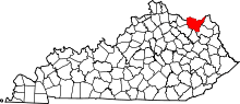 | |
| CDP | ||
| Other unincorporated communities | ||
This article is issued from
Wikipedia.
The text is licensed under Creative Commons - Attribution - Sharealike.
Additional terms may apply for the media files.