Green County, Kentucky
| Green County, Kentucky | |
|---|---|
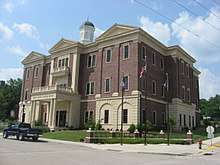 Green County Courthouse in Greensburg, Kentucky. | |
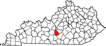 Location in the U.S. state of Kentucky | |
 Kentucky's location in the U.S. | |
| Founded | December 20, 1792 |
| Named for | Nathanael Greene |
| Seat | Greensburg |
| Largest city | Greensburg |
| Area | |
| • Total | 289 sq mi (749 km2) |
| • Land | 286 sq mi (741 km2) |
| • Water | 2.8 sq mi (7 km2), 1.0% |
| Population | |
| • (2010) | 11,258 |
| • Density | 39/sq mi (15/km2) |
| Congressional district | 2nd |
| Time zone | Central: UTC−6/−5 |
| Website |
www |
Green County is a county located in the U.S. state of Kentucky. As of the 2010 census, the population was 11,258.[1] Its county seat is Greensburg.[2] Green was a prohibition or dry county but has not been since 2015.
History
Green County was formed in 1792 from portions of Lincoln and Nelson Counties.[3] Green was the 16th Kentucky county in order of formation.[4] The county is named for Revolutionary War hero General Nathanael Greene, but the reason why the final E is missing is unknown.[5][6]
Three courthouses have served Green County. In 1804, a brick building replaced an earlier structure, and while no longer operational, it stands in the Downtown Greensburg Historic District as the oldest courthouse building in the commonwealth. The present courthouse dates from 1931.[7]
Geography
According to the U.S. Census Bureau, the county has a total area of 289 square miles (750 km2), of which 286 square miles (740 km2) is land and 2.8 square miles (7.3 km2) (1.0%) is water.[8]
Green County is in the central time zone.
Adjacent counties
- LaRue County (north/EST Border)
- Taylor County (northeast/EST Border)
- Adair County (southeast)
- Metcalfe County (southwest)
- Hart County (west)
Demographics
| Historical population | |||
|---|---|---|---|
| Census | Pop. | %± | |
| 1800 | 6,096 | — | |
| 1810 | 6,735 | 10.5% | |
| 1820 | 11,943 | 77.3% | |
| 1830 | 13,138 | 10.0% | |
| 1840 | 14,212 | 8.2% | |
| 1850 | 9,060 | −36.3% | |
| 1860 | 8,806 | −2.8% | |
| 1870 | 9,379 | 6.5% | |
| 1880 | 11,871 | 26.6% | |
| 1890 | 11,463 | −3.4% | |
| 1900 | 12,255 | 6.9% | |
| 1910 | 11,871 | −3.1% | |
| 1920 | 11,391 | −4.0% | |
| 1930 | 11,401 | 0.1% | |
| 1940 | 12,321 | 8.1% | |
| 1950 | 11,261 | −8.6% | |
| 1960 | 11,249 | −0.1% | |
| 1970 | 10,350 | −8.0% | |
| 1980 | 11,043 | 6.7% | |
| 1990 | 10,371 | −6.1% | |
| 2000 | 11,518 | 11.1% | |
| 2010 | 11,258 | −2.3% | |
| Est. 2016 | 11,060 | [9] | −1.8% |
| U.S. Decennial Census[10] 1790-1960[11] 1900-1990[12] 1990-2000[13] 2010-2013[1] | |||
As of the census[14] of 2000, there were 11,518 people, 4,706 households, and 3,378 families residing in the county. The population density was 40 per square mile (15/km2). There were 5,420 housing units at an average density of 19 per square mile (7.3/km2). The racial makeup of the county was 96.19% White, 2.61% Black or African American, 0.10% Native American, 0.13% Asian, 0.31% from other races, and 0.65% from two or more races. 0.95% of the population were Hispanic or Latino of any race.
There were 4,706 households out of which 29.90% had children under the age of 18 living with them, 59.70% were married couples living together, 8.50% had a female householder with no husband present, and 28.20% were non-families. 25.40% of all households were made up of individuals and 13.20% had someone living alone who was 65 years of age or older. The average household size was 2.41 and the average family size was 2.87.
In the county, the population was spread out with 22.70% under the age of 18, 8.10% from 18 to 24, 26.80% from 25 to 44, 25.40% from 45 to 64, and 16.90% who were 65 years of age or older. The median age was 40 years. For every 100 females there were 96.90 males. For every 100 females age 18 and over, there were 91.90 males.
The median income for a household in the county was $25,463, and the median income for a family was $31,852. Males had a median income of $25,764 versus $17,510 for females. The per capita income for the county was $16,107. About 15.20% of families and 18.40% of the population were below the poverty line, including 23.10% of those under age 18 and 18.50% of those age 65 or over.
Communities
City
- Greensburg (county seat)
Census-designated place
Other unincorporated places
Notable people
- Junius George Groves, an American farmer and entrepreneur
- Henry Skaggs (January 8, 1724 – December 4, 1810), an American longhunter, explorer and pioneer
Politics
| Year | Republican | Democratic | Third parties |
|---|---|---|---|
| 2016 | 82.0% 4,372 | 15.6% 832 | 2.4% 129 |
| 2012 | 74.8% 3,634 | 24.0% 1,165 | 1.2% 57 |
| 2008 | 74.5% 3,785 | 23.7% 1,204 | 1.8% 90 |
| 2004 | 74.3% 3,866 | 25.2% 1,312 | 0.5% 28 |
| 2000 | 76.0% 3,615 | 22.8% 1,085 | 1.2% 56 |
| 1996 | 60.9% 2,763 | 28.3% 1,285 | 10.8% 492 |
| 1992 | 54.3% 2,709 | 35.3% 1,760 | 10.4% 517 |
| 1988 | 66.1% 3,139 | 33.6% 1,595 | 0.4% 17 |
| 1984 | 66.4% 3,210 | 33.3% 1,611 | 0.4% 17 |
| 1980 | 60.5% 2,775 | 38.3% 1,758 | 1.2% 54 |
| 1976 | 53.0% 2,397 | 46.1% 2,085 | 0.8% 37 |
| 1972 | 68.8% 2,755 | 30.2% 1,209 | 1.0% 39 |
| 1968 | 58.7% 2,448 | 24.1% 1,003 | 17.2% 719 |
| 1964 | 49.2% 2,110 | 50.4% 2,160 | 0.4% 16 |
| 1960 | 69.5% 3,606 | 30.5% 1,580 | 0.0% 0 |
| 1956 | 62.9% 2,951 | 36.8% 1,726 | 0.3% 12 |
| 1952 | 59.8% 2,773 | 40.0% 1,857 | 0.2% 11 |
| 1948 | 56.0% 2,186 | 41.7% 1,628 | 2.4% 92 |
| 1944 | 56.4% 2,379 | 42.9% 1,809 | 0.7% 31 |
| 1940 | 55.4% 2,497 | 44.2% 1,993 | 0.4% 18 |
| 1936 | 54.2% 2,336 | 45.7% 1,970 | 0.1% 6 |
| 1932 | 49.8% 2,281 | 49.7% 2,277 | 0.6% 25 |
| 1928 | 68.8% 2,824 | 31.0% 1,272 | 0.2% 6 |
| 1924 | 55.2% 1,920 | 44.5% 1,548 | 0.4% 13 |
| 1920 | 57.0% 2,310 | 42.5% 1,723 | 0.4% 17 |
| 1916 | 52.9% 1,412 | 46.4% 1,239 | 0.7% 19 |
| 1912 | 27.7% 687 | 45.0% 1,117 | 27.3% 679 |
See also
References
- 1 2 "State & County QuickFacts". United States Census Bureau. Archived from the original on July 11, 2011. Retrieved March 6, 2014.
- ↑ "Find a County". National Association of Counties. Archived from the original on 2011-05-31. Retrieved 2011-06-07.
- ↑ "Green County". The Kentucky Encyclopedia. 2000. Retrieved August 21, 2014.
- ↑ Collins, Lewis (1882). Collins' Historical Sketches of Kentucky: History of Kentucky, Volume 2. Collins & Company. p. 26.
- ↑ Rennick, Robert M. (1987). Kentucky Place Names. University Press of Kentucky. p. 125. Retrieved 2013-04-28.
- ↑ Gannett, Henry (1905). The Origin of Certain Place Names in the United States. Govt. Print. Off. p. 143.
- ↑ Hogan, Roseann Reinemuth (1992). Kentucky Ancestry: A Guide to Genealogical and Historical Research. Ancestry Publishing. p. 241. Retrieved 26 July 2013.
- ↑ "2010 Census Gazetteer Files". United States Census Bureau. August 22, 2012. Archived from the original on August 12, 2014. Retrieved August 14, 2014.
- ↑ "Population and Housing Unit Estimates". Retrieved June 9, 2017.
- ↑ "U.S. Decennial Census". United States Census Bureau. Archived from the original on May 12, 2015. Retrieved August 14, 2014.
- ↑ "Historical Census Browser". University of Virginia Library. Retrieved August 14, 2014.
- ↑ "Population of Counties by Decennial Census: 1900 to 1990". United States Census Bureau. Retrieved August 14, 2014.
- ↑ "Census 2000 PHC-T-4. Ranking Tables for Counties: 1990 and 2000" (PDF). United States Census Bureau. Retrieved August 14, 2014.
- ↑ "American FactFinder". United States Census Bureau. Archived from the original on 2013-09-11. Retrieved 2008-01-31.
- ↑ Leip, David. "Dave Leip's Atlas of U.S. Presidential Elections". uselectionatlas.org. Retrieved 2018-07-01.
External links
Municipalities and communities of Green County, Kentucky, United States | ||
|---|---|---|
| City | | |
| CDP | ||
| Other unincorporated communities | ||
