Black Gnat, Kentucky
| Black Gnat, Kentucky | |
|---|---|
| Unincorporated community | |
 Black Gnat  Black Gnat | |
| Coordinates: 37°18′15″N 85°26′11″W / 37.30417°N 85.43639°WCoordinates: 37°18′15″N 85°26′11″W / 37.30417°N 85.43639°W | |
| Country | United States |
| State | Kentucky |
| County | Green and Taylor |
| Elevation | 846 ft (258 m) |
| Time zone | UTC-6 (Central (CST)) |
| • Summer (DST) | UTC-5 (CDT) |
| GNIS feature ID | 507513 |
Black Gnat is an unincorporated community in Green and Taylor Counties in the U.S. state of Kentucky. It lies along Old U.S. Route 68 between the cities of Campbellsville and Greensburg, the county seats of Taylor and Green Counties.[1] Its elevation is 846 feet (258 m).[2]
After the local schoolhouse was painted, it became covered in black gnats. A person remarked about the large number of the black gnats, and the name remained.[3] Black Gnat has been noted for its unusual place name.[4]
References
- ↑ Rand McNally. The Road Atlas '06. Chicago: Rand McNally, 2006, p. 42.
- ↑ U.S. Geological Survey Geographic Names Information System: Black Gnat, Kentucky, Geographic Names Information System, 1979-09-20. Accessed 2007-12-31.
- ↑ Rennick, Charles (1984). Kentucky Place Names. Lexington, KY: University Press of Kentucky. p. 25.
- ↑ Staten, Vince (18 December 2012). Kentucky Curiosities: Quirky Characters, Roadside Oddities & Other Offbeat Stuff. Rowman & Littlefield. p. 80. ISBN 978-0-7627-9270-2.
Municipalities and communities of Green County, Kentucky, United States | ||
|---|---|---|
| City | 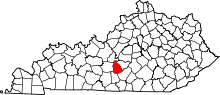 | |
| CDP | ||
| Other unincorporated communities | ||
Municipalities and communities of Taylor County, Kentucky, United States | ||
|---|---|---|
| City | 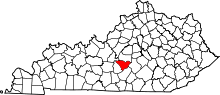 | |
| Unincorporated communities | ||
This article is issued from
Wikipedia.
The text is licensed under Creative Commons - Attribution - Sharealike.
Additional terms may apply for the media files.