Athabasca Valles
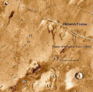 Athabasca Valles showing source of its water, Cerberus Fossae. Note streamined islands which show direction of flow to southwest. | |
| Coordinates | 8°36′N 205°00′W / 8.6°N 205.0°WCoordinates: 8°36′N 205°00′W / 8.6°N 205.0°W |
|---|---|
| Length | 285.0 km (177.1 mi) |
| Naming | River in Canada. (Changed from Athabasca Vallis.) |
Athabasca Valles is an outflow channel on Mars, cut into its surface by catastrophic flooding.
Context
The Athabasca Valles system lies to the south of the Albor Tholus peak of the Elysium volcanic province, the second most significant volcanic province on the planet Mars. It lies within the southern Martian highlands in a diffuse part of the planet's crustal dichotomy. It is a valley that trends northeast-southwest at the southernmost end of the Elysium province. Cerberus Fossae exists uphill to the northeast of the easternmost part of the valley and score the terrain in a perpendicular direction to Athabasca Valles' trend. Downstream to the southwest of the valley system lies the Cerberus Palus plain.[1]
Athabasca Valles is located within the broader Elysium Planitia region, and cross-cuts a vast swath of plains land interpreted to be largely composed of flood basalts. It is the westernmost of the outflow channels in Elysium Planitia and the only one of the channels that exhibits westward flows. The other major outflow channels in the region are (from west to east) Grjotá Valles, Rahway Valles, and Marte Vallis. Of the outflow channels on Mars, Athabasca Valles has been investigated extensively, as crater age estimates suggest that the outflow channel might have formed as recently as 20 Ma - the youngest-known of its kind on Mars - assuming the embaying lava units (upon which the crater dating was performed) were deposited contemporaneously with the outflow channel's formation. Explanations of its formation would allow researchers to better constrain the hydrological conditions in this region of Mars well into the late Amazonian, long after most hydrological activity on the Martian surface is canonically thought to have ceased.[2]
Athabasca Valles is named for the Athabasca River, which runs through Jasper National Park in the Canadian province of Alberta. It was initially named "Athabasca Vallis" (singular form). The International Astronomical Union officially approved the feature's name in 1997.[3]
Geology
There are competing interpretations regarding the formation of the Athabasca Valles system. Historically, Athabasca Valles has been regarded as one of the youngest of the water-formed outflow channels on Mars.[4] Distinctive streamlined teardrop-shaped landforms, branching channels, and ripple dunes (interpreted to have formed under water) are all found within the valley system, and are morphologically similar to those found in the Channeled Scablands on Earth in eastern Washington state. The Channeled Scablands were formed during the catastrophic Missoula Floods, a series of megafloods sourced from sudden breaches in ice dams buttressing the Pleistocene-aged glacial Lake Missoula.[5] According to this interpretation, these lemniscate landforms were created when passing floodwaters deposited sediment against protruding bedrock outcroppings, such as crater rims.[6] The floodwater from the event that formed the Athabasca Valles is thought to have come from Cerberus Fossae at 10°N and 157°E,[6][7] where groundwater may have been trapped under an ice layer that was fractured when the fossae were created.[7][8][9]
However, other authors have noted certain morphological features in Athabasca Valles as inconsistent with this hypothesis, based on very high resolution visual data collected using the HiRISE camera. At the mesoscale, the floor of the valley remains relatively uneroded compared to other Martian outflow channels and those of the Channeled Scablands. The valley floor is characterized by overlapping fronts that become progressively younger towards Cerberus Fossae, concentrically surrounding the fissure vent; this morphology has been interpreted as a series of successive lava flows erupting from the fossae downstream before debouching into the Cerberus Palus basin. These putative flows have ridged and polygonal textures that are consistent with a lava-based provenance, respectively suggestive of situations where lava began to bunch up, and where a solidified surface of lava collapsed as underlying molten rock continued to flow.[1] In this interpretation, the streamlined island-like forms are interpreted to show a highstand where the lava level reached a maximum, prior to the drainage and pooling of molten material into Cerberus Palus.[1]
The viability of a water-based model for Athabasca Valles' formation has also been questioned from a hydrological modeling perspective, with various researchers noting that the region below Cerberus Fossae would require a saturated, extremely deep, and actively recharged reservoir of water preserved below the cryosphere - stored within aquifers with a higher porosity than those typically observed in terrestrial settings. Furthermore, the dike or extensional fracturing that formed Cerberus Fossae would have had to uniformly breach the entirety the thick protective cryosphere to allow the overpressurized groundwater reservoir to escape in sufficient quantities to explain the formation of the Athabasca outflow channel system.[2]
Around 80% of the craters in Athabasca Valles are secondary craters from the impact that created Zunil crater.[10]
Ring-mound landforms
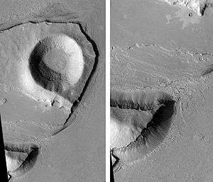
The floor of Athabasca Valles is peppered with thousands of small cones and rings which exist only on the geomorphic unit on the floor of the valley. They are referred to in literature as ring-mound landforms (RMLs). Because the distribution of these landforms are coterminous with this floor unit, they are thought to be indicative of the surface processes that formed the valley system. There are various interpretations that have been offered in the literature.[1]
The hypothesis that Athabasca Valles was formed by a lava flow suggests that these RMLs are actually rootless cones, which form phreatomagmatically as steam is expelled through the solidifying lava flow.[1] Opponents of this hypothesis have noted that moat features surrounding many of the mounds are not typical of terrestrial rootless cones.[11]
If the RMLs of Athabasca Valles are pingoes, this strongly suggests that some combination of sediment and ice comprises the valley floor.[1] The conical landforms observed within the valley system take three distinctive forms—circular mounds, mounds with large central peaks, and irregularly-shaped flat depressions. As seen on THEMIS data, these morphologies are consistent in size and shape with different stages of the pingo lifecycle observed on Earth in the Russian federal subject of Yakutia and the Tuktoyaktuk Peninsula in the Canadian Northwest Territories. Terrestrial pingoes are observed to form from the uplift of the basin of a draining thaw lake. Sudden exposure of the melting permafrost to freezing conditions triggers the uplift as the water content of the saturated ground expands (leading to the formation of the observed circular mounds). As this uplift continues, tensional cracks form near the top of the mound, exposing the ice core of the mound, which loses mass due either to melting or sublimation. Eventually, the core becomes unstable and collapses (forming the pitted mounds, referred to by some authors as "pingo scars"). If the pingo formed over a stable lens of groundwater, this collapse may cause that overpressured water source to erupt as a spring. This causes the total collapse of the pingo and the formation of a depression (the third mentioned irregularly shaped flatter morphologies).[11] Many of the mounds of Athabasca Valles are surrounded by moats, which is a feature of pingoes observed at the Tuktoyaktuk analogue. The densely-packed distribution and irregular, intermelding shapes of the mounds in this area are also common characteristics observed in terrestrial pingo fields.[11]
It has also been hypothesized that the RMLs of Athabasca Valles were formed as volatiles violently degassed from the sediment flows upon which they were entrained, forming what are termed in the literature as "cryophreatic cones".[1]
The RMLs have been proposed by other authors to represent kettle hole lakes formed from deposited ice blocks. This interpretation is consistent with the hypothesis that Athabasca Valles was formed by the erosive action of a mobile glacier.[11]
Because the flood-carved surface is now covered by lava, it is no longer easy to determine the age of the water floods that passed through Athabasca Valles. It is plausible that the flood was triggered by rising magma and hence the water flood and lava flows are essentially contemporaneous, but this has not been confirmed.
Observational history
In a 2007 study, very high spatial resolution images from the HiRISE camera onboard the Mars Reconnaissance Orbiter revealed that all the flood features in Athabasca Valles are draped by lava flows.[1] A later 2010 study described the discovery of a vast single lava flow near Athabasca Valles that is approximately the size of the state of Oregon, that "was put in place turbulently over the span of several weeks at most."[12] This lava flow is the youngest-known one on Mars. It is thought to be of a Late Amazonian Age.[13] Other researchers disagree with this interpretation. Under Martian conditions lava should not stay fluid very long.[14]
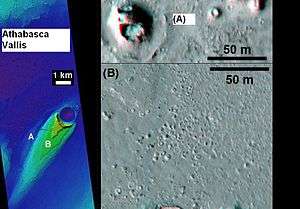
Images from HiRISE in the Athabasca Valles region show features formed by the expansion and contraction of ice. Because these features occur in a channel that was active only 2 million years ago, the features hint at a warmer climate existing later than generally thought. To make the features, ice melted to form liquid water, then refroze. The detailed images from HiRISE show features similar to common landforms on Earth where permafrost is melting (polygonally patterned surfaces, branched channels, blocky debris and mound/cone structures).[15] However, other features in the flow, such as spiral coils similar to terrestrial lava coils, are indicative of a volcanic origin rather than a glacial origin.[16]
Gallery
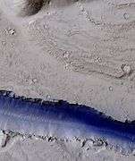 Portion of a trough (fossa) in Elysium, as seen by HiRISE under the HiWish program. Blue indicates probably seasonal frost. Athabasca Vallis originated from large cracks like these.
References
- 1 2 3 4 5 6 7 8 Jaeger, W.L.; et al. (2007). "Athabasca Valles, Mars: A lava-draped channel system". Science. 317 (5845): 1709–1711. Bibcode:2007Sci...317.1709J. doi:10.1126/science.1143315. PMID 17885126.
- 1 2 Cassanelli, J.P.; Head, J.W. (2018). "Large-scale lava-ice interactions on Mars: Investigating its role during Late Amazonian Central Elysium Planitia volcanism and the formation of Athabasca Valles" (PDF). Planetary and Space Science. 158: 96–109.
- ↑ "Athabasca Valles". Gazetteer of Planetary Nomenclature. International Astronomical Union (IAU) Working Group for Planetary System Nomenclature (WGPSN). 2006. Retrieved 13 October 2018.
- ↑ Hydraulic modelling of Athabasca Vallis, Mars / Modelisation hydraulique de Athabasca Vallis, Mars
- ↑ Mars Global Surveyor MOC2-322 Release
- 1 2 http://www.lpi.usra.edu/meetings/lpsc2003/pdf/1066.pdf
- 1 2 Michael H. Carr. The surface of Mars. Cambridge University Press. ISBN 978-0-521-87201-0. Retrieved 21 March 2011.
- ↑ Carr, M. 1979. Formation of martian flood features by release of water from confined aquifers. J. Geophys. Res. 84: 2995–3007.
- ↑ Hanna, J. and R. Phillips. 2005. Tectonic pressurization of aquifers in the formation of Mangala and Athabasca Valles on Mars. LPSC XXXVI. Abstract 2261.
- ↑ McEwen, A.S.; et al. (2005). "The rayed crater Zunil and interpretations of small impact craters on Mars" (PDF). Icarus. 176 (2): 351–381. Bibcode:2005Icar..176..351M. doi:10.1016/j.icarus.2005.02.009.
- 1 2 3 4 Burr, D.M.; Soare, R.J.; Wan Bun Tseung, JM; Emery, J.P. (2005). "Young (late Amazonian), near-surface, ground ice features near the equator, Athabasca Valles, Mars" (PDF). Icarus. 178: 56–73.
- ↑ http://www.jpl.nasa.gov/news/features.cfm?feature=2438
- ↑ Jaeger, W. et al. 2010. Emplacement of the youngest flood lava on Mars: A short, turbulent story. Icarus: 205. 230–243.
- ↑ Cabrol, N. and E. Grin (eds.). 2010. Lakes on Mars. Elsevier. NY.
- ↑ http://www.space.com/scienceastronomy/090629-mars-warm-weather.html
- ↑ Andrew J. Ryan and Philip R. Christensen, Coils and Polygonal Crust in the Athabasca Valles Region, Mars, as Evidence for a Volcanic History, Science 336, 449 (2012); DOI: 10.1126/science.1219437
| Wikimedia Commons has media related to Athabasca Valles. |