Hooke (Martian crater)
 Topographic map of Hooke Crater | |
| Planet | Mars |
|---|---|
| Region | Argyre quadrangle |
| Coordinates | 45°12′S 44°24′W / 45.2°S 44.4°WCoordinates: 45°12′S 44°24′W / 45.2°S 44.4°W |
| Diameter | 139 km |
| Eponym | Robert Hooke |
Hooke Crater is an impact crater in the Argyre quadrangle on Mars at 45.2°S and 44.4°W and is 139.0 km in diameter and is in the north of Argyre Planitia lying next to the Nereidum Montes. Its name was approved in 1973, and it was named after Robert Hooke.[1] The crater is the deepest point in the Argyre Plantia and in the Argyre quadrangle.
Nearby prominent crater is Galle to the southeast and further west is Halley. Surrounding Hooke are smaller named craters on the rim including Yungay to the north, Podor in the northeast and Wau to the east. Touching the northwest rim is Taza and the east rim is Camiri. NNE is the smaller Rengo. Other nearby minor craters include Luga and the tiny Gandu to the west and further southwest is Cypress.
Some of the dunes have gullies on them. While these gullies may be a bit different then ones found on crater walls and other steep slopes, they have been thought by some to be caused by flowing water.
Gallery
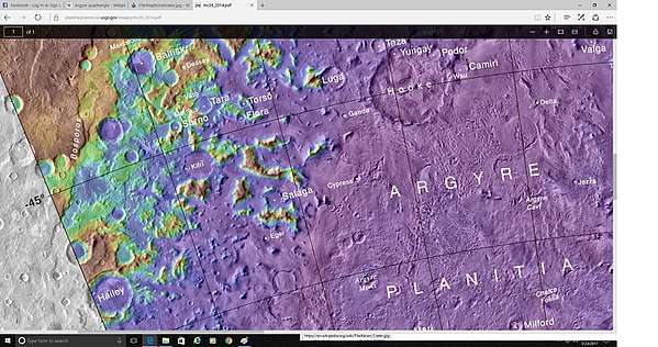 Topo map showing the location of Hooke Crater and other nearby features
 Hooke Crater, as seen by CTX camera (on Mars Reconnaissance Orbiter). Dark places are dunes.
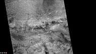 Dust devil tracks in and around Hooke Crater, as seen by CTX camera (on Mars Reconnaissance Orbiter). Note: this is an enlargement of the previous image of Hooke Crater.
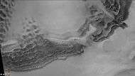 Dunes and gullies in Hooke Crater, as seen by CTX camera (on Mars Reconnaissance Orbiter). Note: this is an enlargement of a previous image of Hooke Crater.
 Dunes and dust devil tracks in Hooke Crater, as seen by HiRISE. There are also gullies just visible.
See also
References
External links
