Ross (Martian crater)
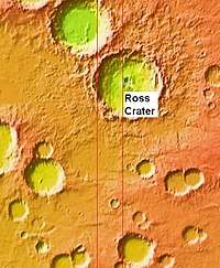 Ross Crater as seen by MOLA which shows the elevations. | |
| Planet | Mars |
|---|---|
| Coordinates | 57°42′S 107°50′W / 57.7°S 107.84°WCoordinates: 57°42′S 107°50′W / 57.7°S 107.84°W |
| Diameter | 82.51 km |
| Eponym | Frank E. Ross, an American astronomer (1874-1960) |
Ross is an impact crater in the Thaumasia quadrangle of Mars located at 57.7 S and 107.84 W. It is 82.51 km in diameter. It was named after Frank E. Ross, an American astronomer (1874-1960). The crater's name was approved in 1973.[1]
Description
The only nearby named crater is Lamont located over a crater diameter nearly to the west. Also to the northeast is Thaumasia Fossae and Icaria Planum and east is Aonia Terra.
The crater features a central peak and its crater rim mare mountains. Between 25 and 30 km northwest is a slightly smaller crater without a name.
Surrounding the crater are numerous gullies, they are on the narrow rim of a crater and they start at different heights and are not caused by aquifers. Some of the gullies shows multiple channels. Some of these shows polygons and some are streamlined forms in channels.
Gullies
Gullies occur on steep slopes, especially on the walls of craters. Gullies are believed to be relatively young because they have few, if any craters. Moreover, they lie on top of sand dunes which themselves are considered to be quite young. Usually, each gully has an alcove, channel, and apron. Some studies have found that gullies occur on slopes that face all directions,[2] others have found that the greater number of gullies are found on poleward facing slopes, especially from 30-44 S.[3]
For years, many believed that gullies were formed by running water, but further observations demonstrate that they may be formed by dry ice. Recent studies describe using the High Resolution Imaging Science Experiment (HiRISE) camera on MRO to examine gullies at 356 sites, starting in 2006. Thirty-eight of the sites showed active gully formation. Before-and-after images demonstrated the timing of this activity coincided with seasonal carbon dioxide frost and temperatures that would not have allowed for liquid water. When dry ice frost changes to a gas, it may lubricate dry material to flow especially on steep slopes.[4][5][6] In some years frost, perhaps as thick as 1 meter, triggers avalanches. This frost contains mostly dry ice, but also has tiny amounts of water ice.[7]
Polygons
Some surfaces on Mars display polygons. These may be of different sizes. Polygons are an example of patterned ground. Polygonal, patterned ground is quite common in some regions of Mars.[8][9][10][11][12][13][14]
Images
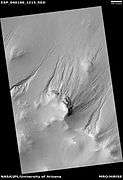
 Ross Crater, as seen by CTX camera (on Mars Reconnaissance Orbiter).
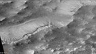 Gullies on southern wall of Ross Crater, as seen by CTX camera (on Mars Reconnaissance Orbiter). Note: this is an enlargement from the previous photo.
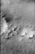 CTX image of part of Ross Crater showing context for next image from HiRISE.
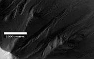 Gullies in Ross Crater, as seen by HiRISE under the HiWish program. Because the gullies are on the narrow rim of a crater and they start at different heights, this example is not consistent with the model of gullies being caused by aquifers.
 Gullies in Ross Crater, as seen by HiRISE under HiWish program
 Group of gullies in Ross Crater, as seen by HiRISE under HiWish program
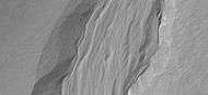 Close-up of gullies showing multiple channels, as seen by HiRISE under HiWish program Note: this is an enlargement of a previous image.
 Close-up of gullies showing polygons, as seen by HiRISE under HiWish program Polygons usually form in frozen ice-rich ground. Note: this is an enlargement of a previous image.
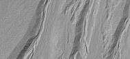 Close-up of gullies showing streamlined forms in channels, as seen by HiRISE under HiWish program Note: this is an enlargement of a previous image.
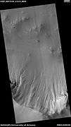 Wide view of gullies in Ross Crater, as seen by HiRISE under HiWish program
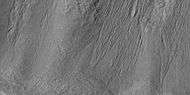 Close view of many small gullies in Ross Crater, as seen by HiRISE under HiWish program Note: this is an enlargement of a previous image.
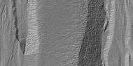 Close view of polygons near gullies in Ross Crater, as seen by HiRISE under HiWish program Note: this is an enlargement of a previous image.
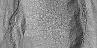 Close view of polygons near gullies in Ross Crater, as seen by HiRISE under HiWish program Note: this is an enlargement of a previous image.
See also
References
- ↑ "Gazetteer of Planetary Nomenclature | Ross". usgs.gov. International Astronomical Union. Retrieved 5 March 2015.
- ↑ Edgett, K.; Malin, M. C.; Williams, R. M. E.; Davis, S. D. (2003). "Polar-and middle-latitude martian gullies: A view from MGS MOC after 2 Mars years in the mapping orbit" (PDF). Lunar Planet. Sci. 34. p. 1038, Abstract 1038. Bibcode:2003LPI....34.1038E.
- ↑ Dickson, J; Head, J; Kreslavsky, M (2007). "Martian gullies in the southern mid-latitudes of Mars: Evidence for climate-controlled formation of young fluvial features based upon local and global topography" (PDF). Icarus. 188 (2): 315–323. Bibcode:2007Icar..188..315D. doi:10.1016/j.icarus.2006.11.020.
- ↑ http://www.jpl.nasa.gov/news/news.php?release=2014-226
- ↑ http://hirise.lpl.arizona.edu/ESP_032078_1420
- ↑ http://www.space.com/26534-mars-gullies-dry-ice.html
- ↑ http://spaceref.com/mars/frosty-gullies-on-mars.html
- ↑ http://www.diss.fu-berlin.de/diss/servlets/MCRFileNodeSe%5Bpermanent+dead+link%5D rvlet/FUDISS_derivate_000000003198/16_ColdClimateLandforms-13-utopia.pdf?hosts=
- ↑ Kostama, V.-P., M. Kreslavsky, Head, J. 2006. Recent high-latitude icy mantle in the northern plains of Mars: Characteristics and ages of emplacement. Geophys. Res. Lett. 33 (L11201). doi:10.1029/2006GL025946. K>
- ↑ Malin, M., Edgett, K. 2001. Mars Global Surveyor Mars Orbiter Camera: Interplanetary cruise through primary mission. J. Geophys. Res. 106 (E10), 23429–23540.
- ↑ Milliken, R., et al. 2003. Viscous flow features on the surface of Mars: Observations from high-resolution Mars Orbiter Camera (MOC) images. J. Geophys. Res. 108 (E6). doi:10.1029/2002JE002005.
- ↑ Mangold, N. 2005. High latitude patterned grounds on Mars: Classification, distribution and climatic control. Icarus 174, 336–359.
- ↑ Kreslavsky, M., Head, J. 2000. Kilometer-scale roughness on Mars: Results from MOLA data analysis. J. Geophys. Res. 105 (E11), 26695–26712.
- ↑ Seibert, N., J. Kargel. 2001. Small-scale martian polygonal terrain: Implications for liquid surface water. Geophys. Res. Lett. 28 (5), 899–902. S