Maumee Valles
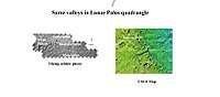 Waters from Vedra Valles, Maumee Valles, and Maja Valles went from Lunae Planum on the left, to Chryse Planitia on the right. Image is located in Lunae Palus quadrangle and was taken by Viking Orbiter. | |
| Coordinates | 19°42′N 53°12′W / 19.7°N 53.2°WCoordinates: 19°42′N 53°12′W / 19.7°N 53.2°W |
|---|---|
Maumee Valles is an ancient river valley in the Lunae Palus quadrangle of Mars, located at 19.7° N and 53.2° W. It is 350.0 km long and was named after a North American river in Indiana and Ohio.[1]
Together with other ancient river valleys, it has provided strong evidence for a great deal of running water on the surface of Mars.[2][3][4]
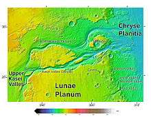 Area around Northern Kasei Valles, showing relationships among Kasei Valles, Bahram Vallis, Vedra Valles, Maumee Valles, and Maja Valles. Map location is in Lunae Palus quadrangle and includes parts of Lunae Planum and Chryse Planitia.
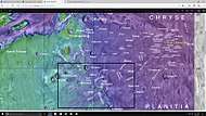 Map showing relative positions of several valleys in Lunae Palus quadrangle, including Vedra Valles, Maumee Valles, and Maja Valles. Box indicates where these valleys can be found. Colors show elevation.
See also
References
- ↑ "Maumee Valles". Gazetteer of Planetary Nomenclature. USGS Astrogeology Science Center. Retrieved 2014-07-11. External link in
|work=(help) - ↑ ISBN 0-8165-1257-4
- ↑ Raeburn, P. 1998. Uncovering the Secrets of the Red Planet Mars. National Geographic Society. Washington D.C.
- ↑ Moore, P. et al. 1990. The Atlas of the Solar System. Mitchell Beazley Publishers NY, NY.
Further reading
- Baker, V.R.; Carr, M.H.; Gulick, V.C.; Williams, C.R. & Marley, M.S. "Channels and Valley Networks". In Kieffer, H.H.; Jakosky, B.M.; Snyder, C.W. & Matthews, M.S. Mars. Tucson, AZ: University of Arizona Press.
- Carr, M.H. "Channels, Valleys and Gullies". The Surface of Mars. Cambridge University Press. ISBN 978-0-521-87201-0.
This article is issued from
Wikipedia.
The text is licensed under Creative Commons - Attribution - Sharealike.
Additional terms may apply for the media files.